

Weather webcast with Lisa Michaels
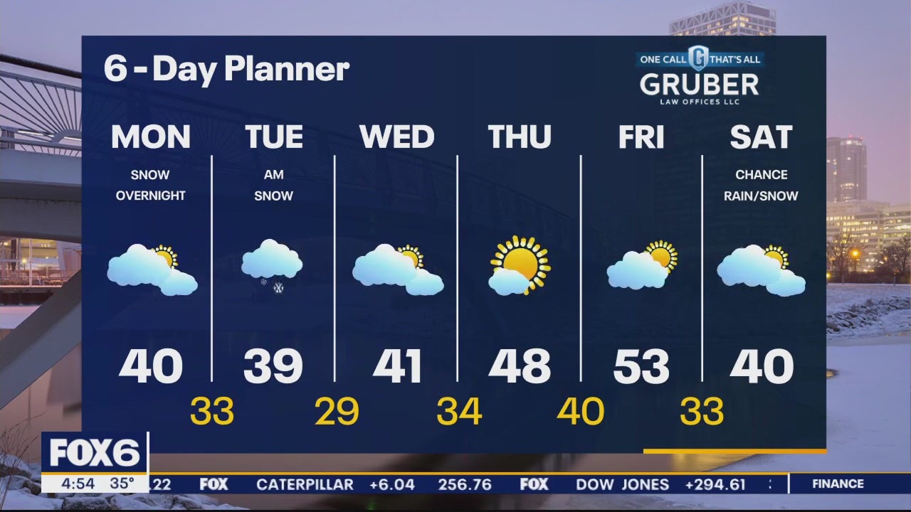
Mostly cloudy on Monday with high around 40. Snow moves in overnight Monday night into Tuesday morning. Around 0.5" of snow is expected. Precipitation gradually ends Tuesday afternoon with highs in the upper 30s. Dry on Wednesday with highs in the low 40s. A late week warming trend in store with the 50s back by Friday. Another system could bring a mix of rain/snow over the weekend.
Mostly cloudy on Monday with high around 40. Snow moves in overnight Monday night into Tuesday morning. Around 0.5" of snow is expected. Precipitation gradually ends Tuesday afternoon with highs in the upper 30s. Dry on Wednesday with highs in the low 40s. A late week warming trend in store with the 50s back by Friday. Another system could bring a mix of rain/snow over the weekend.
Weather Webcast with Tom Wachs
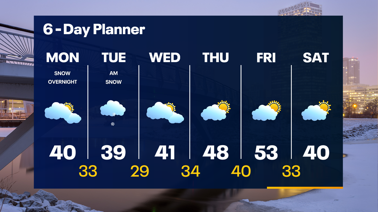
A few icy patches are possible overnight as temperatures drop below freezing away from the lake. Mostly cloudy on Monday with highs between 35-40. Snow showers return overnight Monday night into Tuesday morning.
A few icy patches are possible overnight as temperatures drop below freezing away from the lake. Mostly cloudy on Monday with highs between 35-40. Snow showers return overnight Monday night into Tuesday morning.
Weather Webcast with Tom Wachs
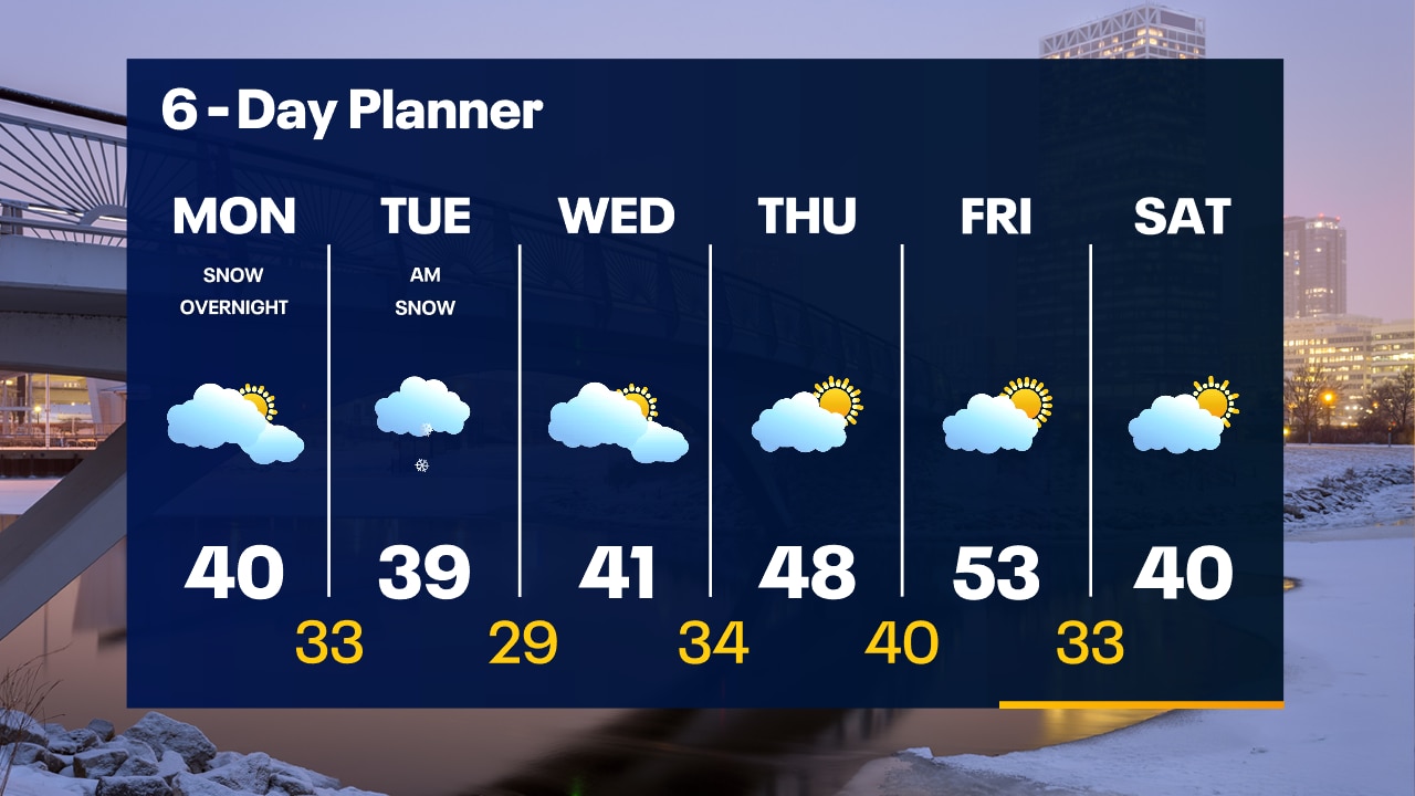
Icy patches are possible away from the lake tonight as temperatures drop. 20s and 30s by morning. Mostly cloudy on Monday with a high between 35-40. Snow returns late Monday night into Tuesday morning.
Icy patches are possible away from the lake tonight as temperatures drop. 20s and 30s by morning. Mostly cloudy on Monday with a high between 35-40. Snow returns late Monday night into Tuesday morning.

Weather webcast with Lisa Michaels
Rain closer to the lake and snow inland. Minor accumulations possible. Precipitation will move taper off in the afternoon leaving cloudy skies and high temps in the upper 30s to low 40F. A day break from precipitation on Monday before another round of snow is possible Monday night into Tuesday.
Rain closer to the lake and snow inland. Minor accumulations possible. Precipitation will move taper off in the afternoon leaving cloudy skies and high temps in the upper 30s to low 40F. A day break from precipitation on Monday before another round of snow is possible Monday night into Tuesday.

Weather Webcast with Meteorologist Eric Manges
Snow and rain again tonight with accumulation potential mostly west
Snow and rain again tonight with accumulation potential mostly west

Weather Webcast with Meteorologist Eric Manges
Two more wintry systems on the way giving us mostly rain but areas West could see some snow
Two more wintry systems on the way giving us mostly rain but areas West could see some snow
Weather webcast with Lisa Michaels
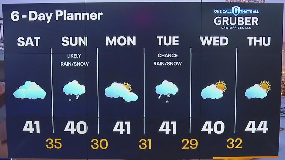
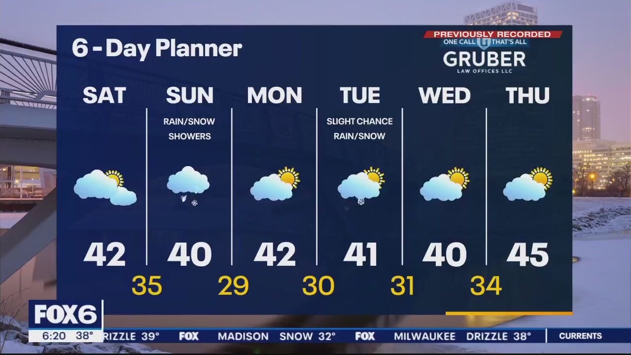
Dry but cloudy on Saturday with highs near 40F. Another system bringing snow inland and rain near the lake Saturday night late into early Sunday. Snow could accumulate on elevated surfaces and in northwestern areas. Half an inch to 1.5" possible.
Dry but cloudy on Saturday with highs near 40F. Another system bringing snow inland and rain near the lake Saturday night late into early Sunday. Snow could accumulate on elevated surfaces and in northwestern areas. Half an inch to 1.5" possible.
Weather Webcast with Meteorologist Eric Manges
Rain and snow potential continues into tonight then another round on Sunday
Rain and snow potential continues into tonight then another round on Sunday
Weather Webcast with Stephanie Barichello
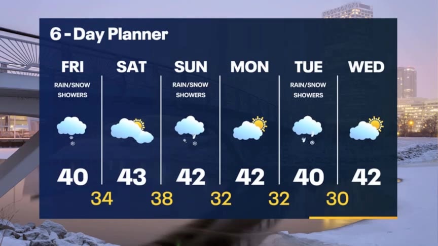
Rain and snow showers continue this afternoon, wrapping up later tonight. A split weekend ahead with dry conditions Saturday and more rain and snow Sunday. Back and forth between dry and wet next week.
Rain and snow showers continue this afternoon, wrapping up later tonight. A split weekend ahead with dry conditions Saturday and more rain and snow Sunday. Back and forth between dry and wet next week.

Weather webcast with Rob Haswell
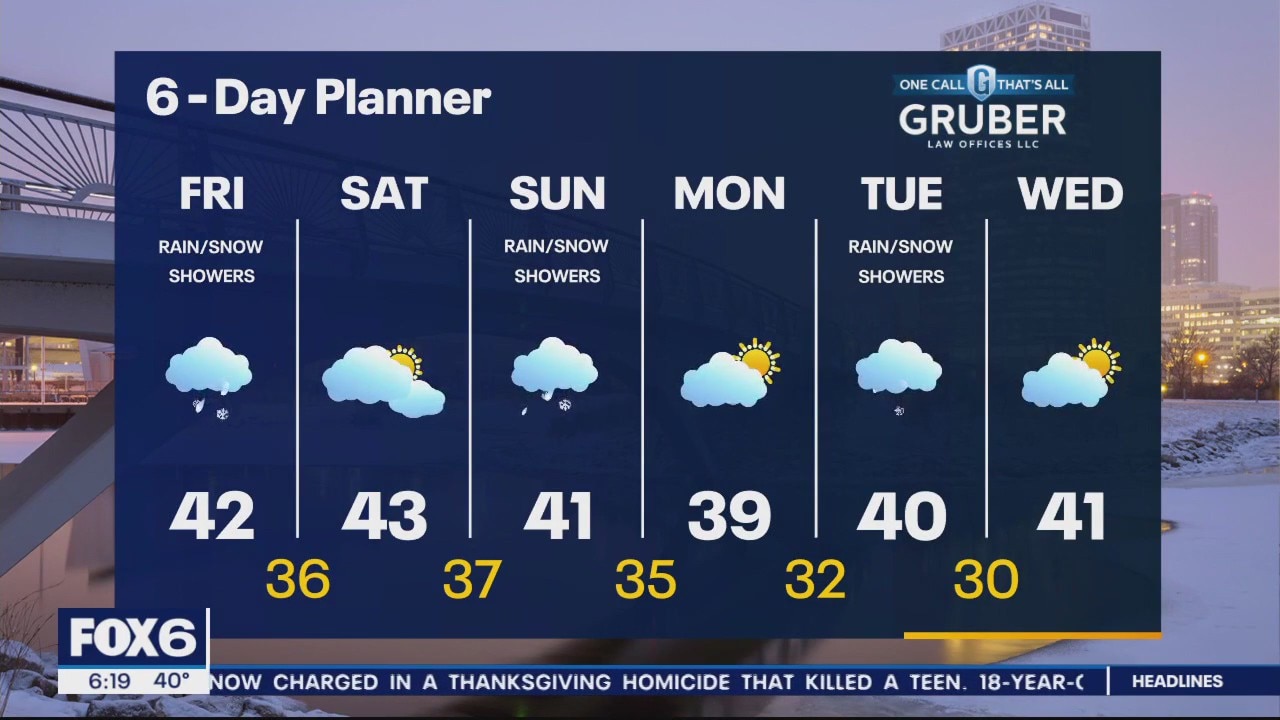
A low moves from Kansas to NW Ohio in the next 24-36 hours putting us on the far NW side of the system. We are mild enough this morning to see mostly rain or a wintry mix from this system but as we cool tonight into Saturday morning we will see more snow - mostly inland. Another system move through late Saturday into Sunday with another chance for light rain and snow. We will stay milder than average for several days.
A low moves from Kansas to NW Ohio in the next 24-36 hours putting us on the far NW side of the system. We are mild enough this morning to see mostly rain or a wintry mix from this system but as we cool tonight into Saturday morning we will see more snow - mostly inland. Another system move through late Saturday into Sunday with another chance for light rain and snow. We will stay milder than average for several days.
Weather Webcast with Meteorologist Eric Manges
Rain/snow chances return Friday especially in the afternoon and evening
Rain/snow chances return Friday especially in the afternoon and evening

Weather webcast with Chief Meteorologist Rob Haswell
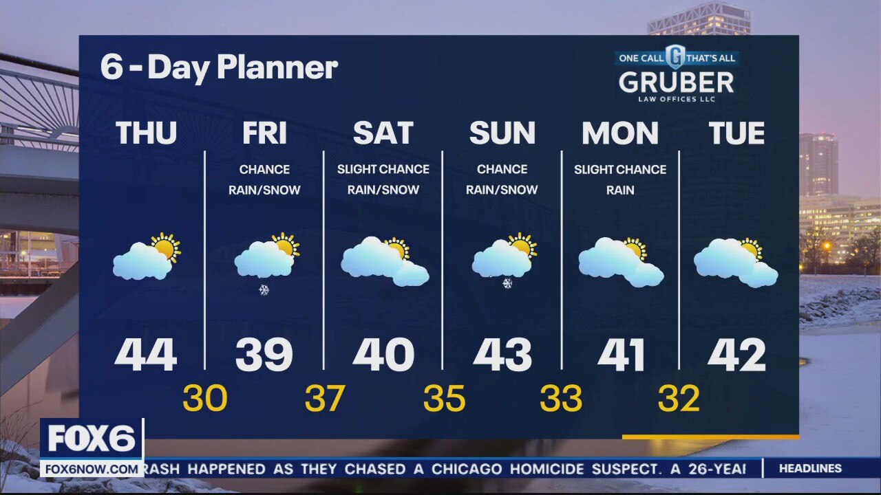
Mild again today with highs once again reaching the low to middle 40s! We should stay seasonal overnight with lows in the upper 20s and low 30s. Conditions become more active starting Friday with a low passing to our south but bringing a chance for rain and snow our way on Friday and into Friday night.
Mild again today with highs once again reaching the low to middle 40s! We should stay seasonal overnight with lows in the upper 20s and low 30s. Conditions become more active starting Friday with a low passing to our south but bringing a chance for rain and snow our way on Friday and into Friday night.
Weather Webcast with Meteorologist Eric Manges
Warmer and more seasonable conditions have returned and are here to stay
Warmer and more seasonable conditions have returned and are here to stay
Weather webcast with Lisa Michaels
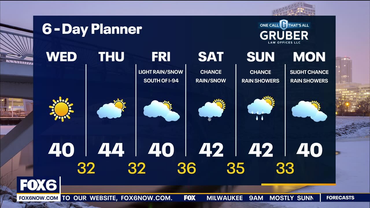
Highs today will be in the upper 30s to near 40 which returns us to the seasonal average range. Partly cloudy skies Thursday with temps a few degrees warmer in the low to mid 40s. Our next chance of precipitation is later on Friday. A wintry mix is possible south of I-94 A few additional systems could bring on and off wintry mix scenarios through the weekend and into early next week.
Highs today will be in the upper 30s to near 40 which returns us to the seasonal average range. Partly cloudy skies Thursday with temps a few degrees warmer in the low to mid 40s. Our next chance of precipitation is later on Friday. A wintry mix is possible south of I-94 A few additional systems could bring on and off wintry mix scenarios through the weekend and into early next week.
Weather webcast with Rob Haswell
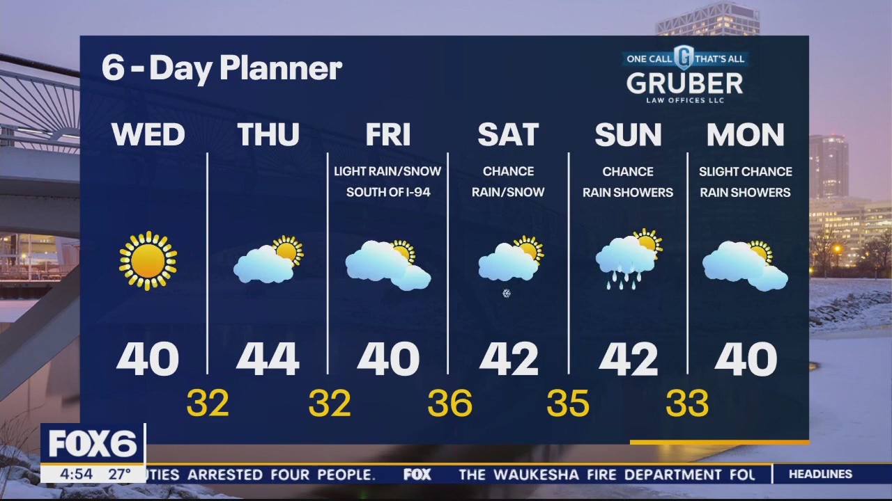
A warm front has finally made its way to the east and ushered in some more seasonal air. Highs today will be in the upper 30s to near 40 which returns us to the seasonal average range.
A warm front has finally made its way to the east and ushered in some more seasonal air. Highs today will be in the upper 30s to near 40 which returns us to the seasonal average range.
Weather Webcast with Tom Wachs
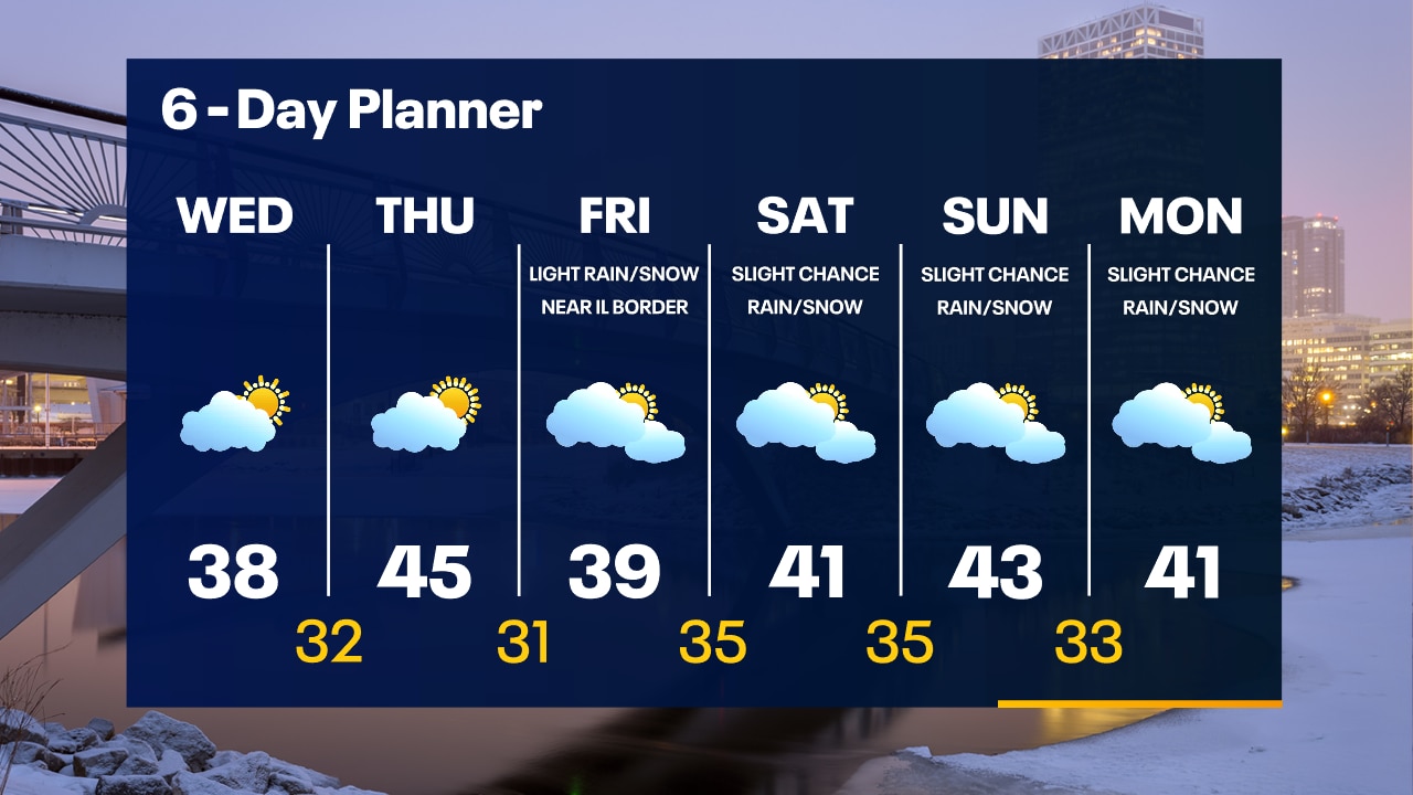
Temperatures slowly rising overnight with windy conditions. Wind chills around +10 through sunrise. Partly sunny and warmer Wednesday afternoon with highs between 35-40.
Temperatures slowly rising overnight with windy conditions. Wind chills around +10 through sunrise. Partly sunny and warmer Wednesday afternoon with highs between 35-40.

Weather Webcast with Tom Wachs
Partly cloudy tonight with wind chills around +10. It will be windy tonight into Wednesday morning. Partly sunny and warmer on Wednesday with highs between 35-40.
Partly cloudy tonight with wind chills around +10. It will be windy tonight into Wednesday morning. Partly sunny and warmer on Wednesday with highs between 35-40.
Weather webcast with Lisa Michaels
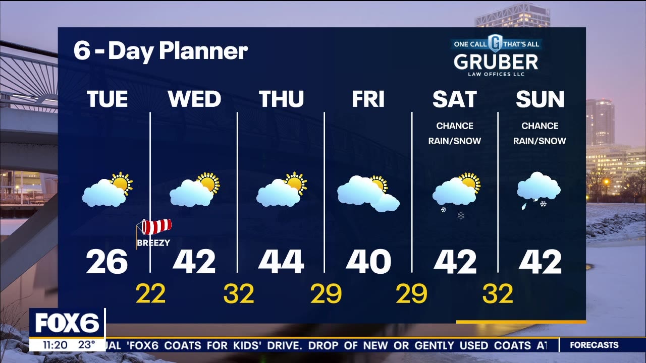
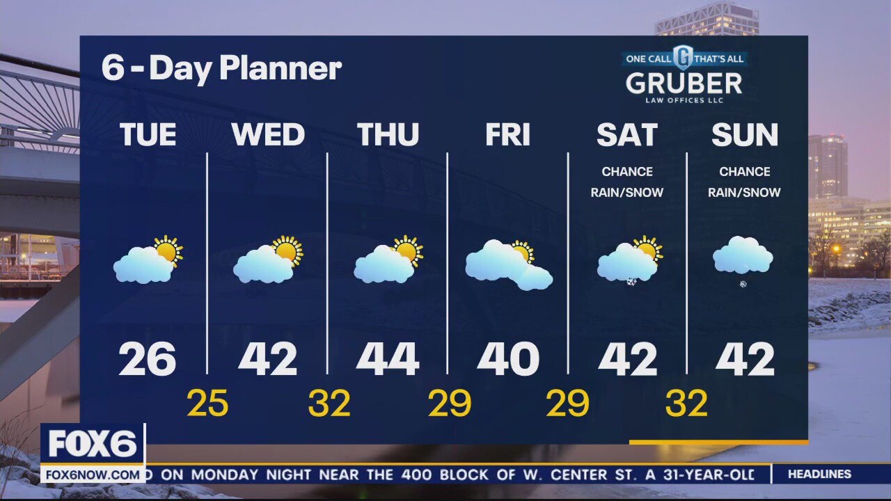
The last very cold day this week with highs in the low to mid 20s. Wind chills remain in the single digits and teens. Breezy overnight, but winds changing out of the southwest and clouds will keep it warmer by Wednesday morning. Highs return into the low 40s Wednesday with partly cloudy skies. High temps in the 40s stay around the rest of the week. Next chance of rain/snow will be over the weekend.
The last very cold day this week with highs in the low to mid 20s. Wind chills remain in the single digits and teens. Breezy overnight, but winds changing out of the southwest and clouds will keep it warmer by Wednesday morning. Highs return into the low 40s Wednesday with partly cloudy skies. High temps in the 40s stay around the rest of the week. Next chance of rain/snow will be over the weekend.
Weather webcast with Rob Haswell
We stay chilly today with highs in the low to mid 20s and feeling colder with the steady breeze.
We stay chilly today with highs in the low to mid 20s and feeling colder with the steady breeze.
Weather Webcast with Tom Wachs
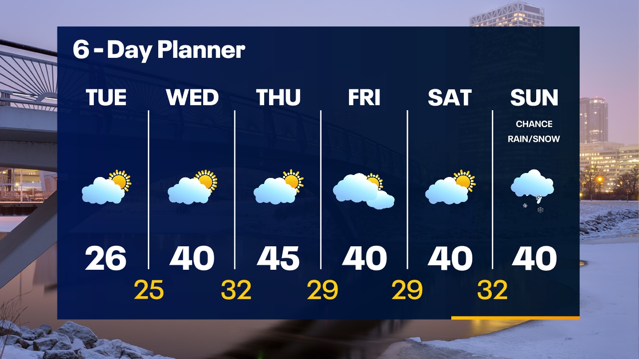
A few flurries overnight with cold and blustery conditions. Wind chills between 0 and -5 by morning. One more cold day on Tuesday with highs in the 20s and afternoon wind chills in the teens. Warming up Wednesday.
A few flurries overnight with cold and blustery conditions. Wind chills between 0 and -5 by morning. One more cold day on Tuesday with highs in the 20s and afternoon wind chills in the teens. Warming up Wednesday.