


Weather Webcast with Tom Wachs
Mostly clear and mild tonight with temperatures holding in the 40s. Increasing clouds on Friday, breezy with highs in the mid-50s. Rain moves in overnight Friday night.
Mostly clear and mild tonight with temperatures holding in the 40s. Increasing clouds on Friday, breezy with highs in the mid-50s. Rain moves in overnight Friday night.
Weather Webcast with Meteorologist Eric Manges
Sunshine and warmer weather to end the week but rain on Saturday
Sunshine and warmer weather to end the week but rain on Saturday
Weather webcast with Rob Haswell
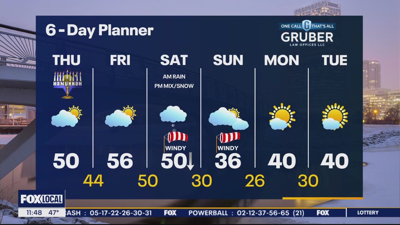
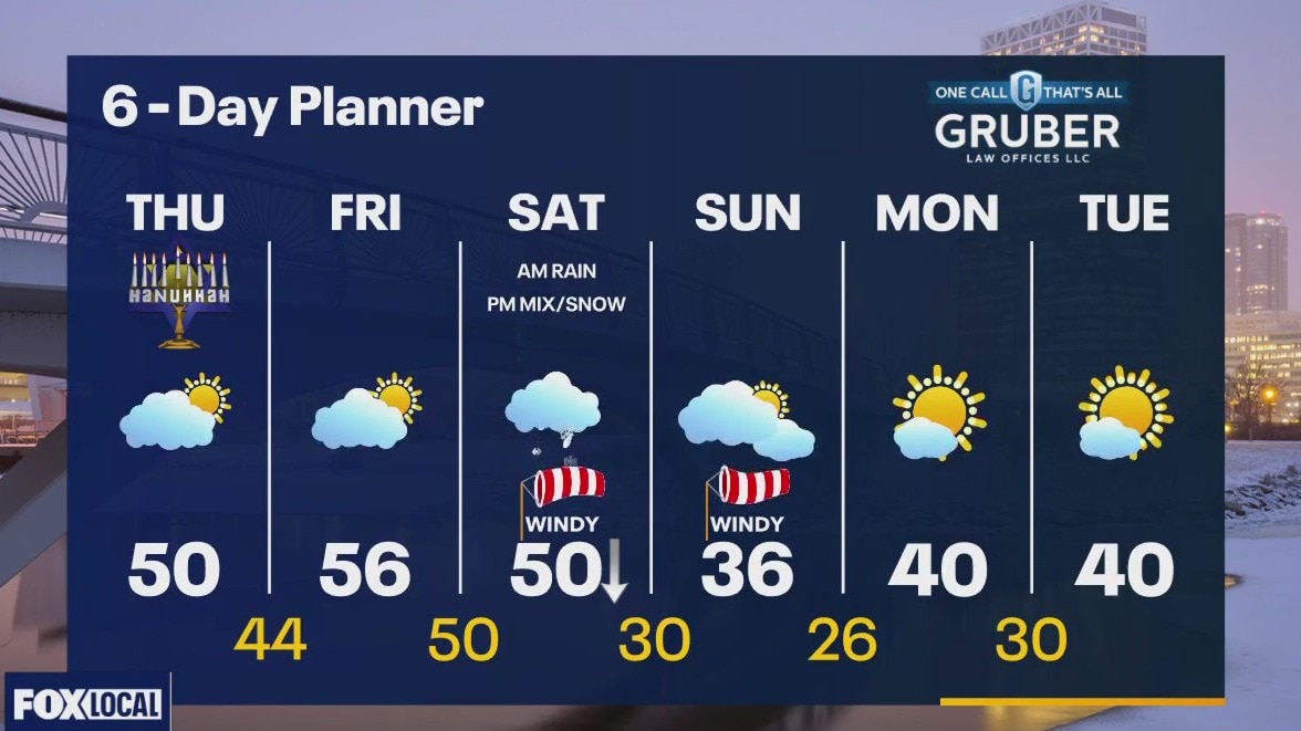
Sunny and mild today with highs reaching the upper 40s and near 50 degrees in most areas! We get cloudier tomorrow as a low moves our way but we stay dry and mild with highs pushing in the mid to upper 50s. That system will bring mostly rain to our are overnight Friday into Saturday morning with a brief transition to snow later Saturday as temperatures fall behind the cold front. Calmer and slightly above seasonal for early next week.
Sunny and mild today with highs reaching the upper 40s and near 50 degrees in most areas! We get cloudier tomorrow as a low moves our way but we stay dry and mild with highs pushing in the mid to upper 50s. That system will bring mostly rain to our are overnight Friday into Saturday morning with a brief transition to snow later Saturday as temperatures fall behind the cold front. Calmer and slightly above seasonal for early next week.

Weather Webcast with Tom Wachs
Decreasing clouds overnight with temperatures in the 30s. Partly sunny on Thursday, warmer with highs between 45-50. Mid-50s on Friday.
Decreasing clouds overnight with temperatures in the 30s. Partly sunny on Thursday, warmer with highs between 45-50. Mid-50s on Friday.
Weather Webcast with Tom Wachs
Mostly cloudy and breezy tonight with temperatures in the 30s. Partly sunny and warmer on Thursday with highs between 45-50. Mid-50s on Friday.
Mostly cloudy and breezy tonight with temperatures in the 30s. Partly sunny and warmer on Thursday with highs between 45-50. Mid-50s on Friday.
Weather Webcast with Stephanie Barichello
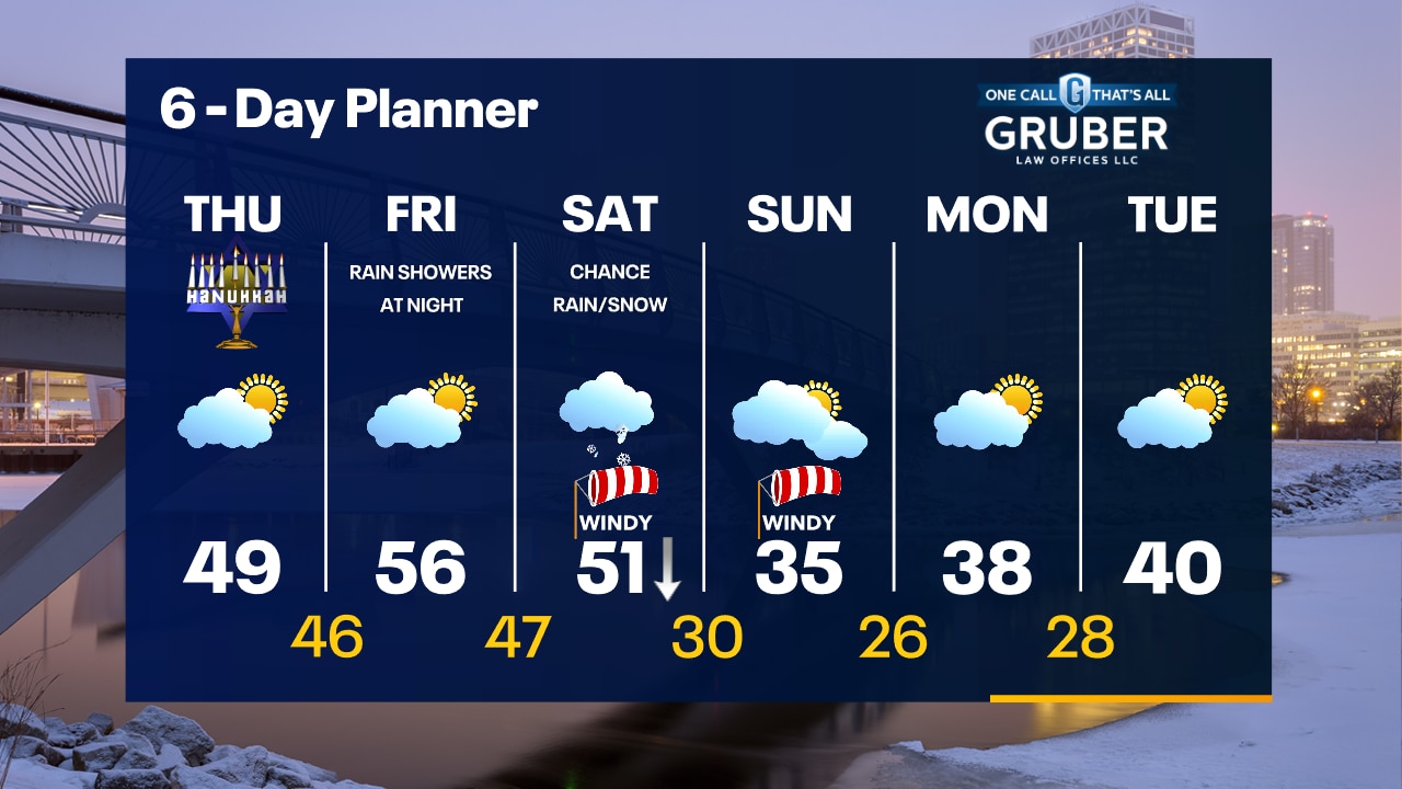
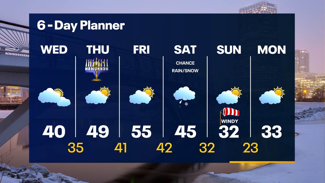
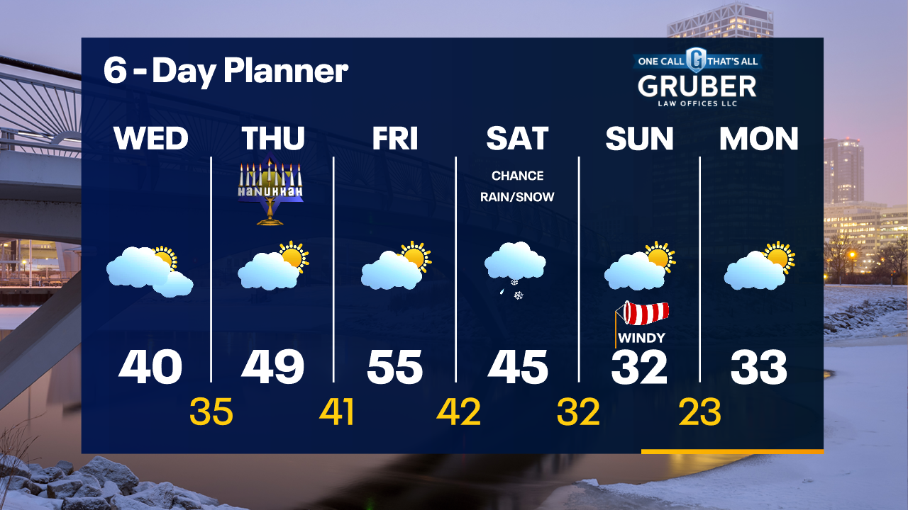
Gradually warming in the days ahead plus we finally see some sunshine. Our next storm system will bring rain and snow Saturday, but the exact storm track will determine what precip type we see more of. Stay tuned. Much colder by Sunday.
Gradually warming in the days ahead plus we finally see some sunshine. Our next storm system will bring rain and snow Saturday, but the exact storm track will determine what precip type we see more of. Stay tuned. Much colder by Sunday.
Weather webcast with Lisa Michaels
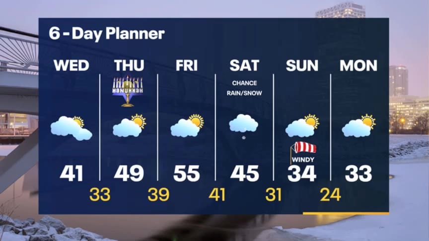
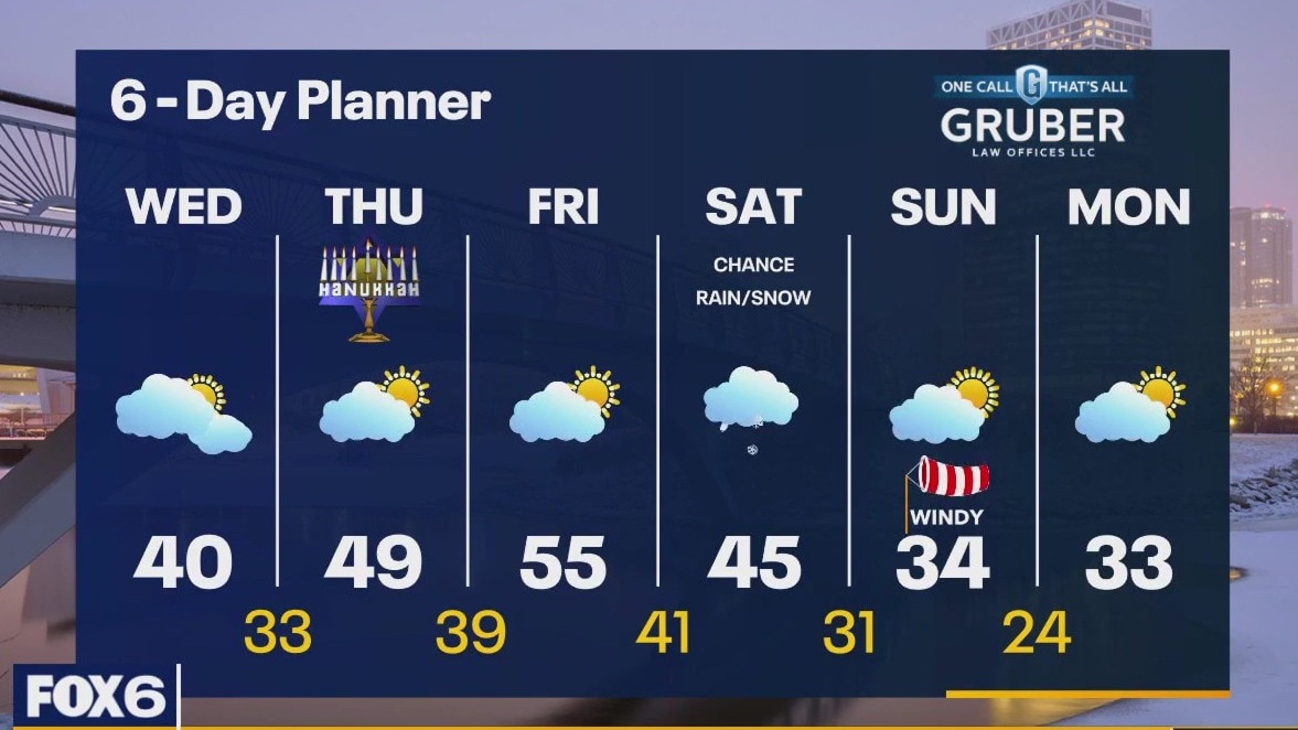
Mostly cloudy on Wednesday. High temps in the mid 30s to 40F near the lake. Wind chills will be in the low 30s. Dry for the rest of the week with a big warm up on the way. Highs near 50F on Thursday and the mid-50s on Friday. We are watching a system that could bring us rain and snow on Saturday. Much cooler Sunday and Monday.
Mostly cloudy on Wednesday. High temps in the mid 30s to 40F near the lake. Wind chills will be in the low 30s. Dry for the rest of the week with a big warm up on the way. Highs near 50F on Thursday and the mid-50s on Friday. We are watching a system that could bring us rain and snow on Saturday. Much cooler Sunday and Monday.
Weather Webcast with Tom Wachs
Mostly cloudy overnight with temperatures in the upper 20s to low 30s by sunrise. Mostly cloudy and breezy on Wednesday with highs around 40. Warming up Thursday and Friday.
Mostly cloudy overnight with temperatures in the upper 20s to low 30s by sunrise. Mostly cloudy and breezy on Wednesday with highs around 40. Warming up Thursday and Friday.
Weather Webcast with Tom Wachs
Mostly cloudy tonight with temperatures in the 30s. Mostly cloudy again on Wednesday with highs around 40. Warming into the 50s by the end of the week.
Mostly cloudy tonight with temperatures in the 30s. Mostly cloudy again on Wednesday with highs around 40. Warming into the 50s by the end of the week.
Weather webcast with Lisa Michaels
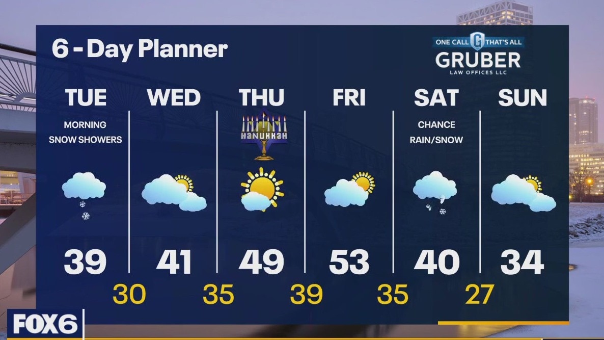
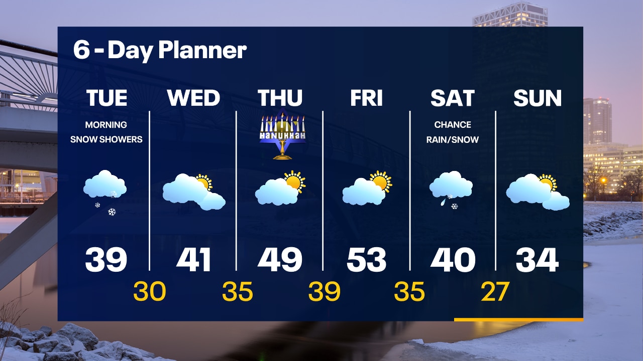
Light snow across the areas during the morning. Snow will mainly accumulate near the border. Snow will taper off by the afternoon with highs in the upper 30s. Dry mid-week with a warm up. Highs in the 40s Wednesday and Thursday, 50s return on Friday. We are watching a potentially stronger storm system for Saturday. Unclear if it will miss us or not at this point. Right now, there is a chance for rain/snow on Saturday.
Light snow across the areas during the morning. Snow will mainly accumulate near the border. Snow will taper off by the afternoon with highs in the upper 30s. Dry mid-week with a warm up. Highs in the 40s Wednesday and Thursday, 50s return on Friday. We are watching a potentially stronger storm system for Saturday. Unclear if it will miss us or not at this point. Right now, there is a chance for rain/snow on Saturday.
Weather Webcast with Tom Wachs
Light snow moves in overnight and continues through the AM commute. A few tenths of an inch is expected which could slow things down in the morning.
Light snow moves in overnight and continues through the AM commute. A few tenths of an inch is expected which could slow things down in the morning.
Weather Webcast with Stephanie Barichello
Cloudy today, then snow expected overnight and throughout Tuesday morning. Lakeshore communities will likely see more of a wintry mix as temperatures rise in the morning. Up to 1" possible, but expect impacts to the morning commute. Warm up briefly late-week.
Cloudy today, then snow expected overnight and throughout Tuesday morning. Lakeshore communities will likely see more of a wintry mix as temperatures rise in the morning. Up to 1" possible, but expect impacts to the morning commute. Warm up briefly late-week.
Weather webcast with Lisa Michaels
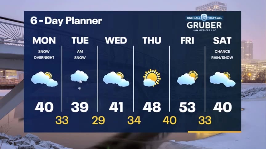
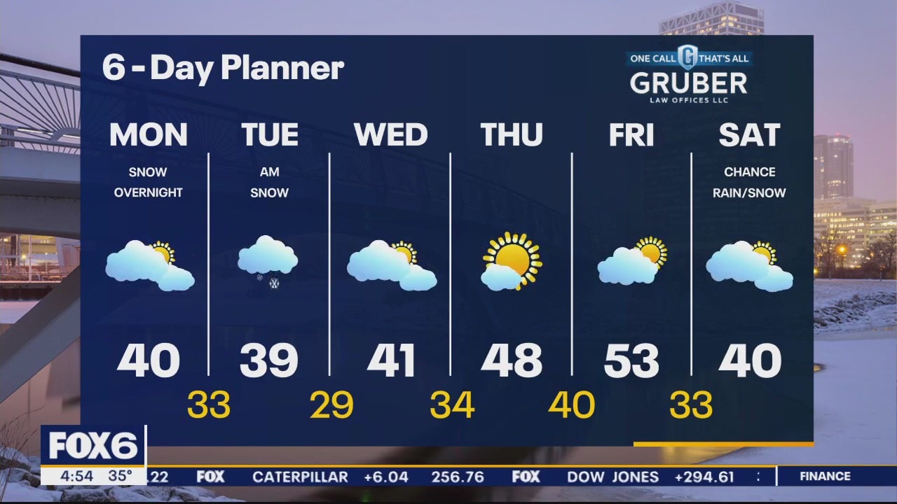
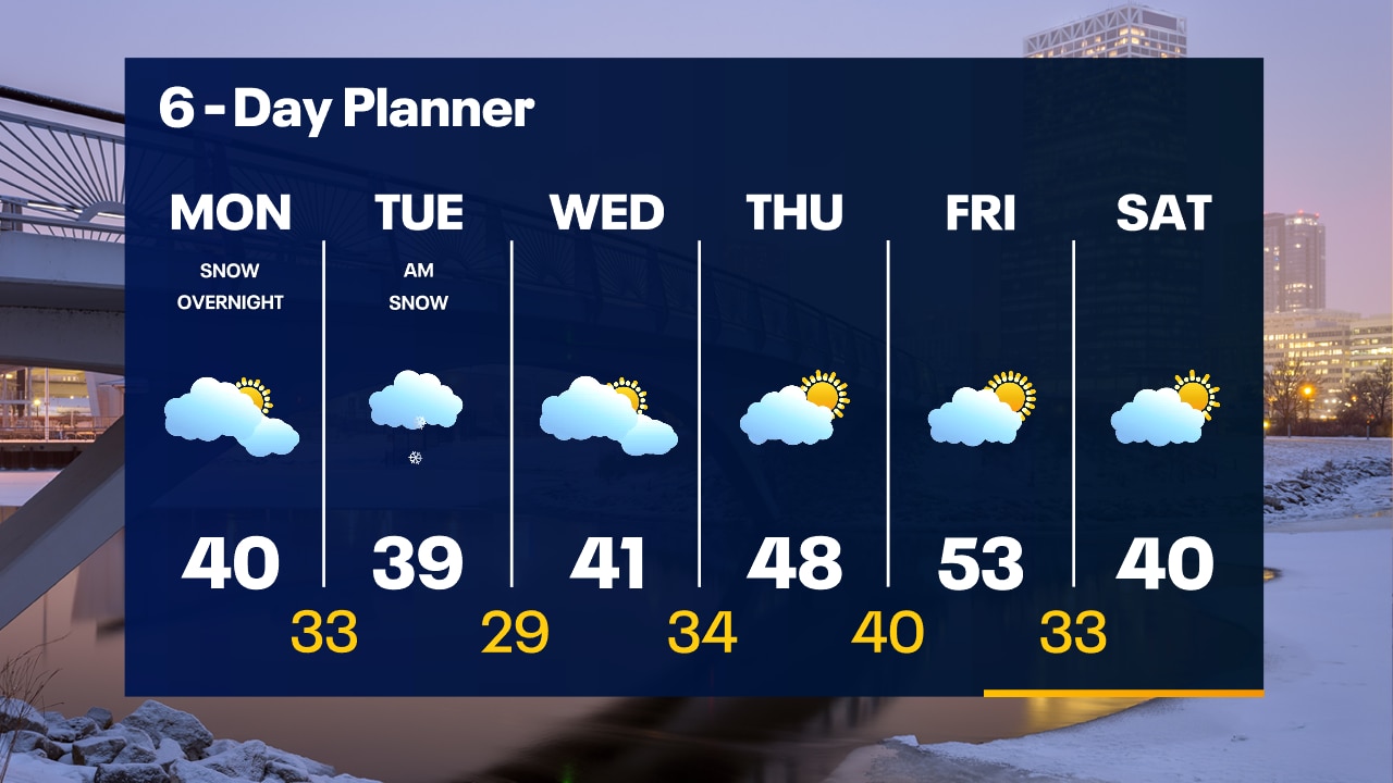
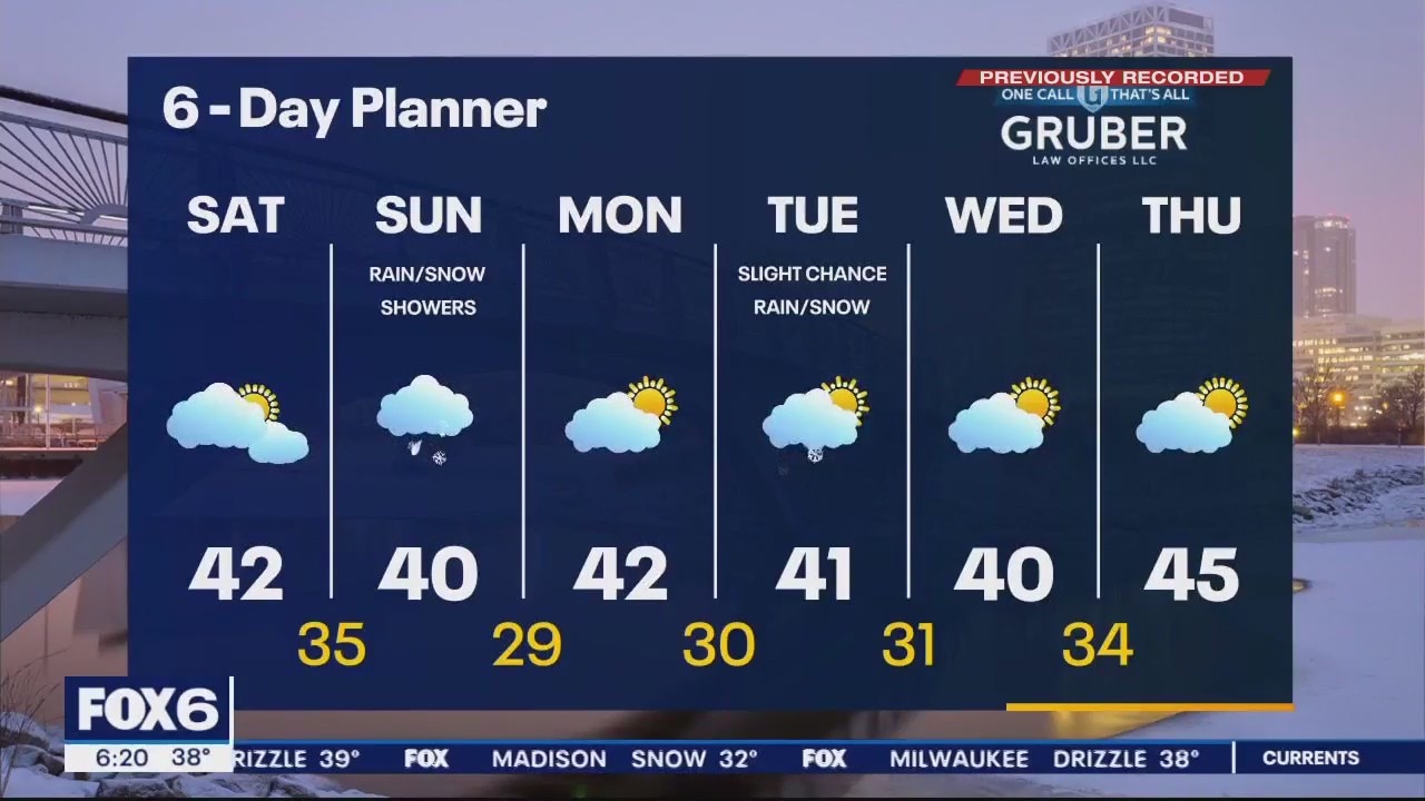
Mostly cloudy on Monday with high around 40. Snow moves in overnight Monday night into Tuesday morning. Around 0.5" of snow is expected. Precipitation gradually ends Tuesday afternoon with highs in the upper 30s. Dry on Wednesday with highs in the low 40s. A late week warming trend in store with the 50s back by Friday. Another system could bring a mix of rain/snow over the weekend.
Mostly cloudy on Monday with high around 40. Snow moves in overnight Monday night into Tuesday morning. Around 0.5" of snow is expected. Precipitation gradually ends Tuesday afternoon with highs in the upper 30s. Dry on Wednesday with highs in the low 40s. A late week warming trend in store with the 50s back by Friday. Another system could bring a mix of rain/snow over the weekend.

Weather Webcast with Tom Wachs
A few icy patches are possible overnight as temperatures drop below freezing away from the lake. Mostly cloudy on Monday with highs between 35-40. Snow showers return overnight Monday night into Tuesday morning.
A few icy patches are possible overnight as temperatures drop below freezing away from the lake. Mostly cloudy on Monday with highs between 35-40. Snow showers return overnight Monday night into Tuesday morning.
Weather Webcast with Tom Wachs
Icy patches are possible away from the lake tonight as temperatures drop. 20s and 30s by morning. Mostly cloudy on Monday with a high between 35-40. Snow returns late Monday night into Tuesday morning.
Icy patches are possible away from the lake tonight as temperatures drop. 20s and 30s by morning. Mostly cloudy on Monday with a high between 35-40. Snow returns late Monday night into Tuesday morning.

Weather webcast with Lisa Michaels
Rain closer to the lake and snow inland. Minor accumulations possible. Precipitation will move taper off in the afternoon leaving cloudy skies and high temps in the upper 30s to low 40F. A day break from precipitation on Monday before another round of snow is possible Monday night into Tuesday.
Rain closer to the lake and snow inland. Minor accumulations possible. Precipitation will move taper off in the afternoon leaving cloudy skies and high temps in the upper 30s to low 40F. A day break from precipitation on Monday before another round of snow is possible Monday night into Tuesday.

Weather Webcast with Meteorologist Eric Manges
Snow and rain again tonight with accumulation potential mostly west
Snow and rain again tonight with accumulation potential mostly west

Weather Webcast with Meteorologist Eric Manges
Two more wintry systems on the way giving us mostly rain but areas West could see some snow
Two more wintry systems on the way giving us mostly rain but areas West could see some snow
Weather webcast with Lisa Michaels
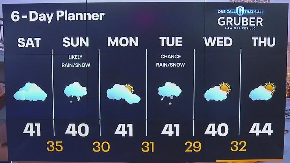
Dry but cloudy on Saturday with highs near 40F. Another system bringing snow inland and rain near the lake Saturday night late into early Sunday. Snow could accumulate on elevated surfaces and in northwestern areas. Half an inch to 1.5" possible.
Dry but cloudy on Saturday with highs near 40F. Another system bringing snow inland and rain near the lake Saturday night late into early Sunday. Snow could accumulate on elevated surfaces and in northwestern areas. Half an inch to 1.5" possible.
Weather Webcast with Meteorologist Eric Manges
Rain and snow potential continues into tonight then another round on Sunday
Rain and snow potential continues into tonight then another round on Sunday