

Weather webcast with Lisa Michaels
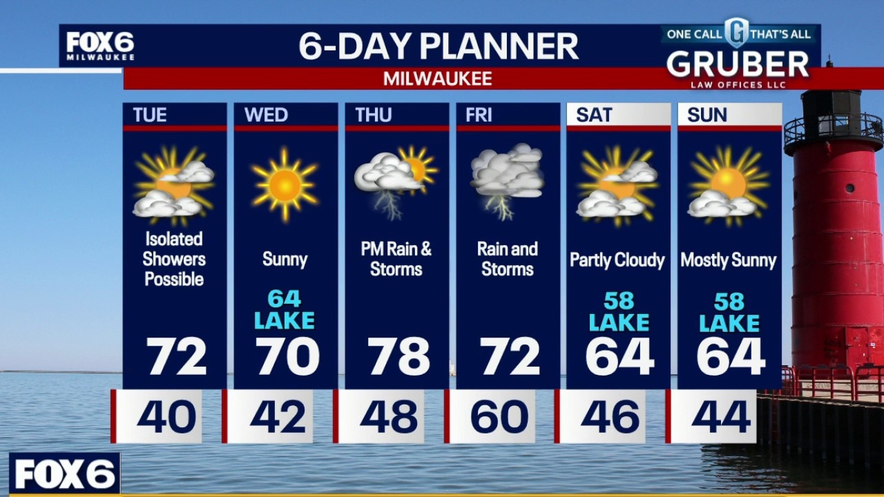
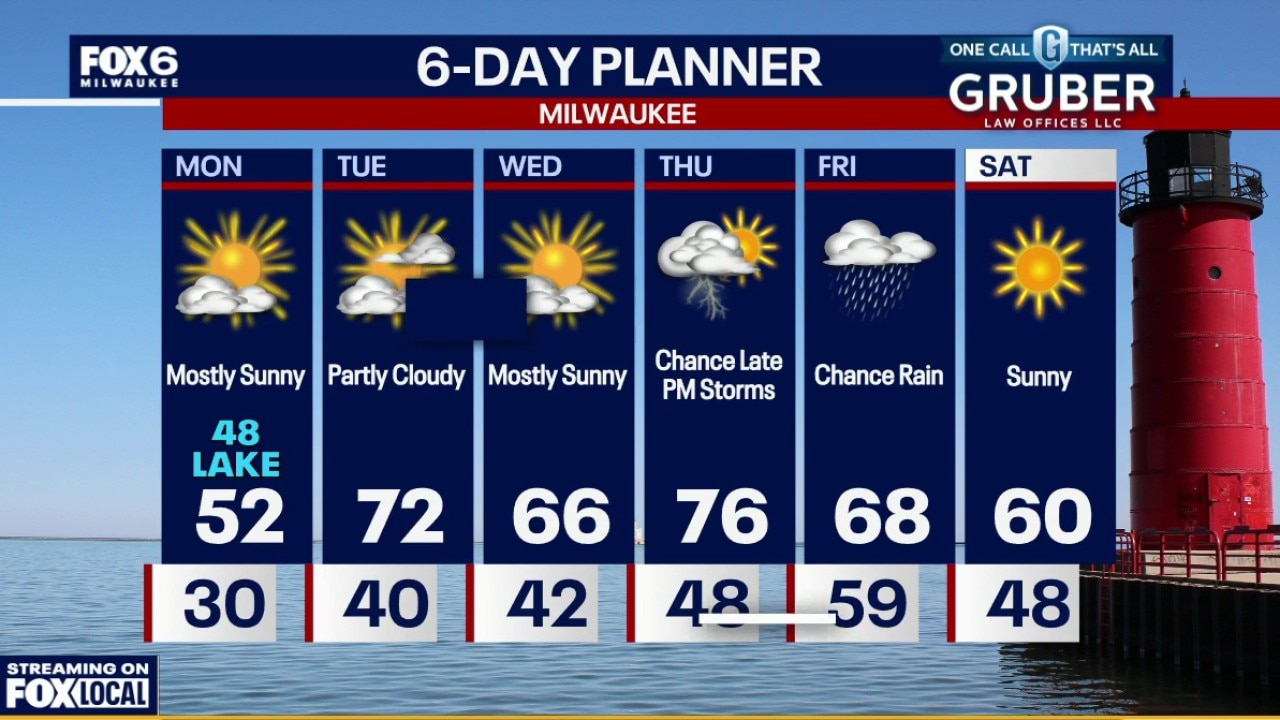
A stretch of unseasonably warm weather settles into southern Wisconsin through midweek, with highs climbing well into the 70s and even approaching 80 degrees inland by Wednesday.
A stretch of unseasonably warm weather settles into southern Wisconsin through midweek, with highs climbing well into the 70s and even approaching 80 degrees inland by Wednesday.
Weather webcast with Rob Haswell
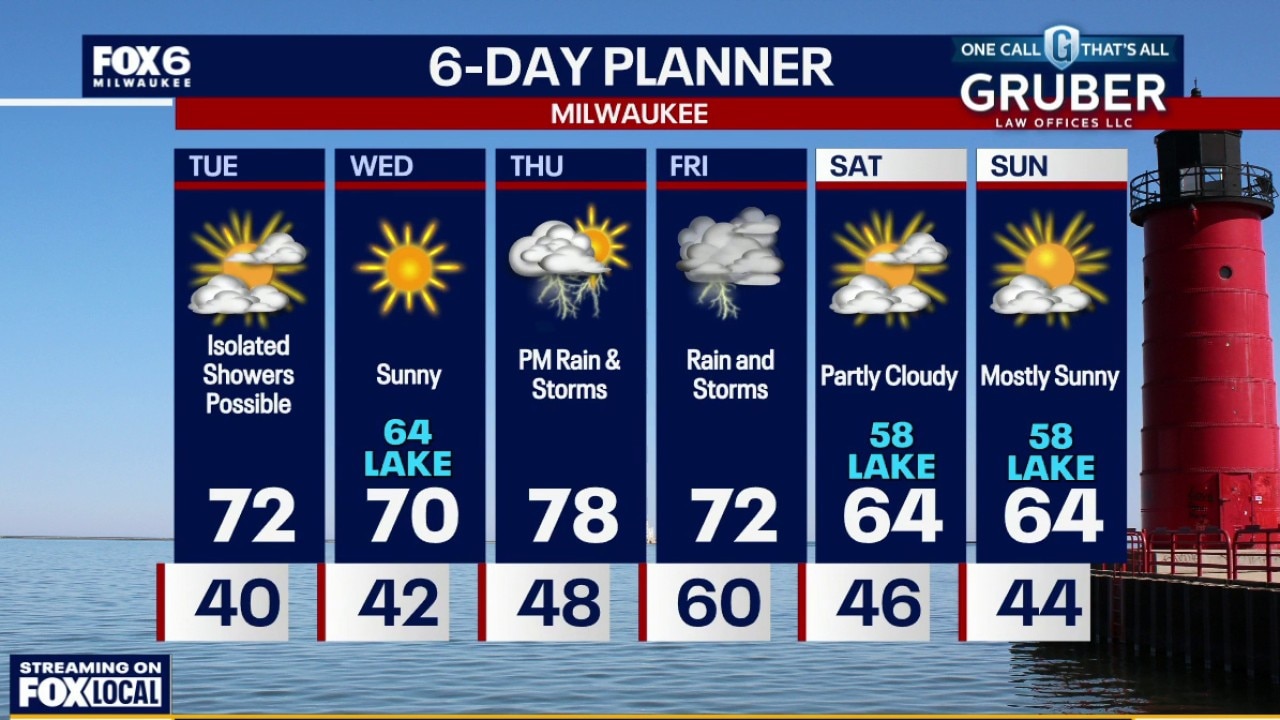
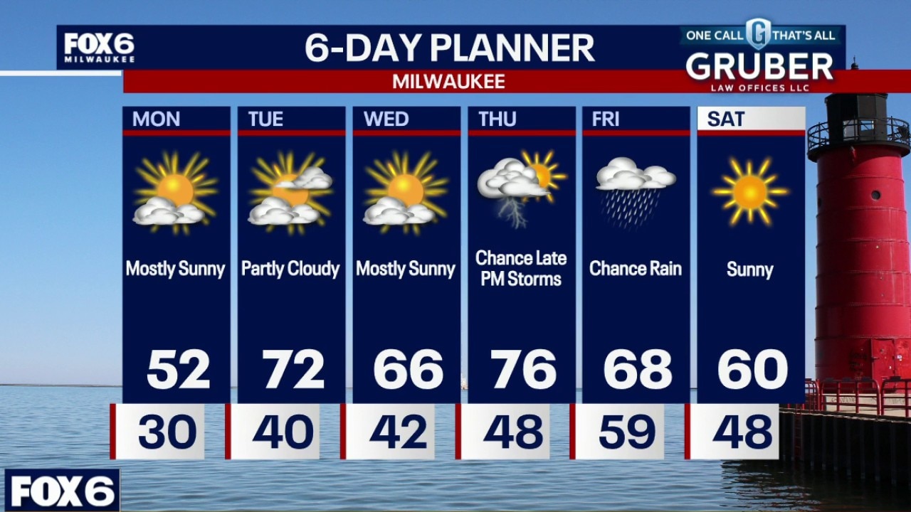
A stretch of unseasonably warm weather settles into southern Wisconsin through midweek, with highs climbing well into the 70s and even approaching 80 degrees inland by Wednesday.
A stretch of unseasonably warm weather settles into southern Wisconsin through midweek, with highs climbing well into the 70s and even approaching 80 degrees inland by Wednesday.
Weather Webcast with Chief Meteorologist Tom Wachs
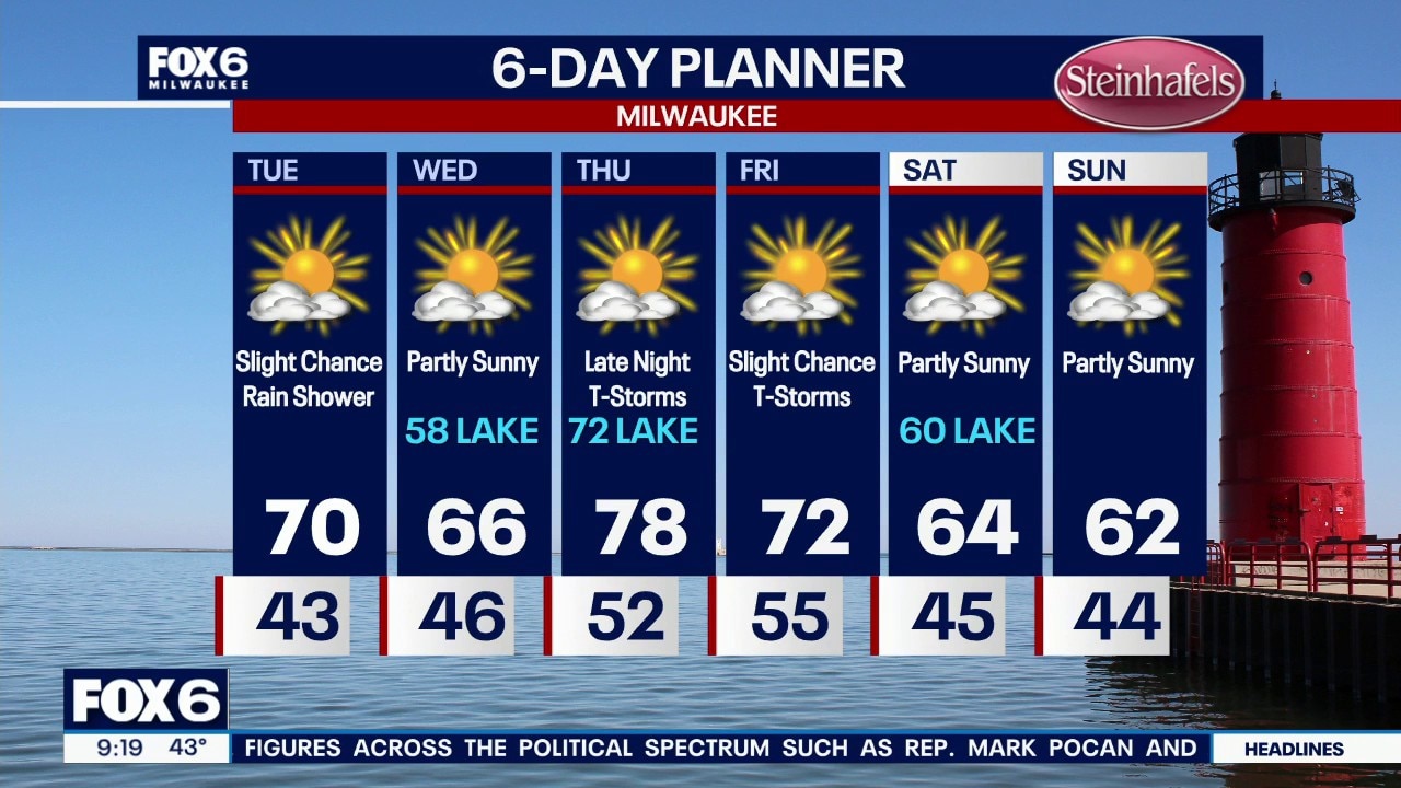
Mostly clear and chilly tonight. Temperatures holding steady in the low 40s with blustery southerly winds. Partly sunny and warmer on Tuesday with a high around 70. Slight chance for a shower midday. Cooler on Wednesday, especially near the lake with highs in the upper 50s lakeside, mid-60s far inland.
Mostly clear and chilly tonight. Temperatures holding steady in the low 40s with blustery southerly winds. Partly sunny and warmer on Tuesday with a high around 70. Slight chance for a shower midday. Cooler on Wednesday, especially near the lake with highs in the upper 50s lakeside, mid-60s far inland.
Weather Webcast with Chief Meteorologist Tom Wachs
Mostly clear and chilly tonight. Temperatures holding steady in the low 40s with blustery southerly winds. Partly sunny and warmer on Tuesday with a high around 70. Cooler on Wednesday, especially near the lake with highs in the upper 50s lakeside, mid-60s far inland.
Mostly clear and chilly tonight. Temperatures holding steady in the low 40s with blustery southerly winds. Partly sunny and warmer on Tuesday with a high around 70. Cooler on Wednesday, especially near the lake with highs in the upper 50s lakeside, mid-60s far inland.
Weather webcast with Stephanie Barichello
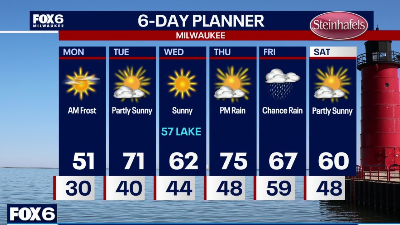
A cold start gives way to a warming trend across southern Wisconsin this week. After a frost Monday morning, temperatures climb into well above normal readings by midweek.
A cold start gives way to a warming trend across southern Wisconsin this week. After a frost Monday morning, temperatures climb into well above normal readings by midweek.
Weather webcast with Rob Haswell
A cold start gives way to a warming trend across southern Wisconsin this week. After a frost Monday morning, temperatures climb into well above normal readings by midweek.
A cold start gives way to a warming trend across southern Wisconsin this week. After a frost Monday morning, temperatures climb into well above normal readings by midweek.
Weather Webcast with Holly Baker
Beautiful weather is on the way.
Beautiful weather is on the way.
Weather webcast with meteorologist Lisa Michaels
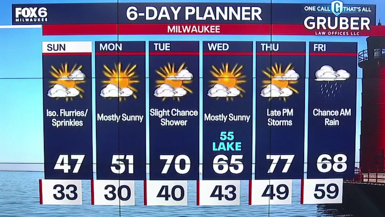
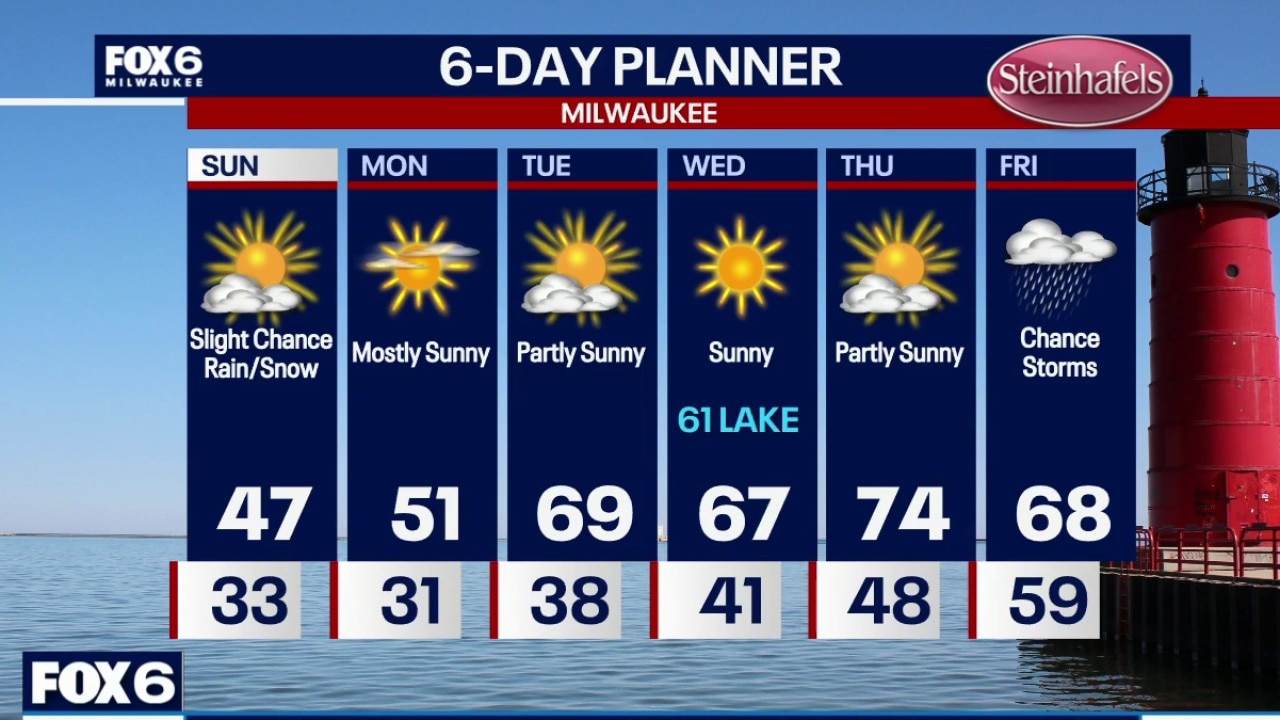
River flood warning continue through next week. Partly cloudy Sunday with a slight chance for flurries/sprinkles. Cool, highs in the mid to upper 40s. Temperatures drop near and below freezing Sunday night into Monday morning. Widespread frost is expected.
River flood warning continue through next week. Partly cloudy Sunday with a slight chance for flurries/sprinkles. Cool, highs in the mid to upper 40s. Temperatures drop near and below freezing Sunday night into Monday morning. Widespread frost is expected.
Weather Webcast with Holly Baker
A quieter pattern will be setting up over the next couple of days.
A quieter pattern will be setting up over the next couple of days.
Weather webcast with meteorologist Lisa Michaels
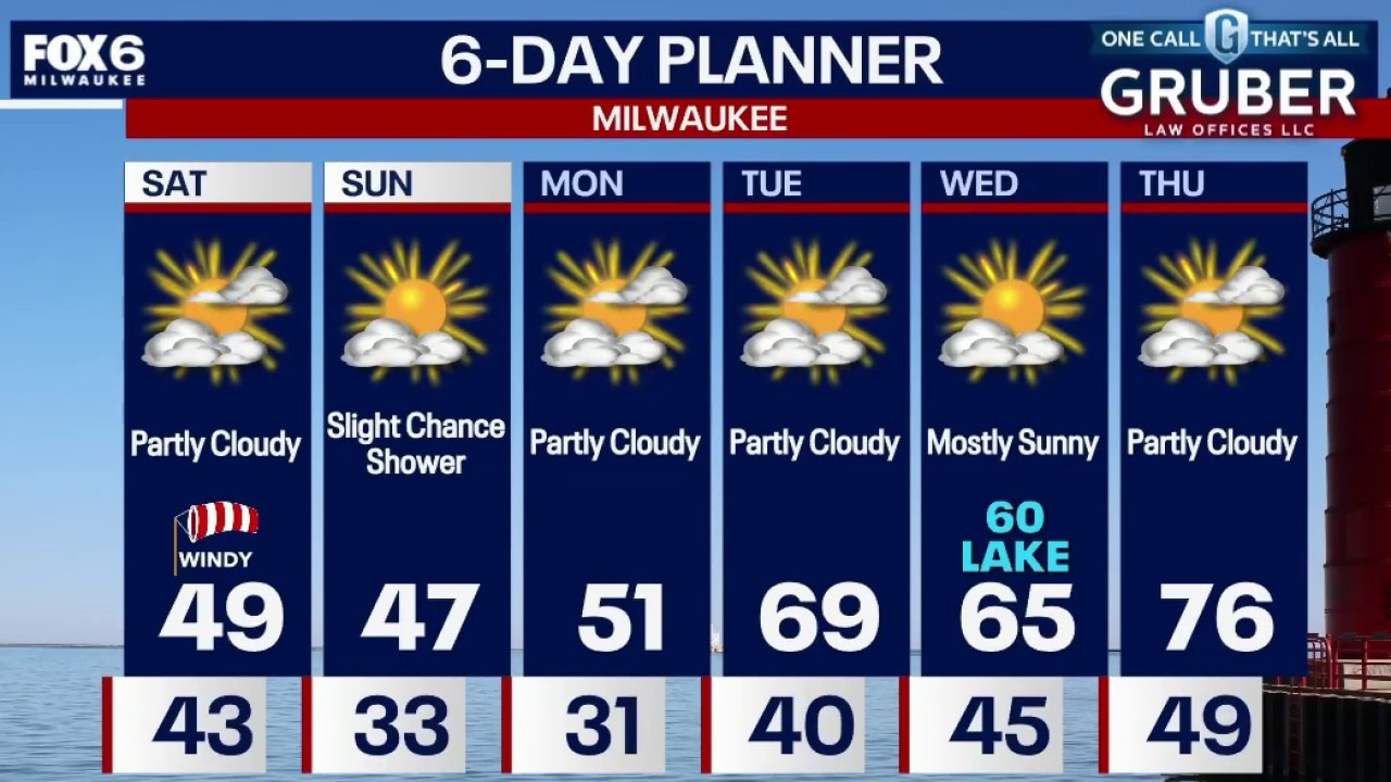
River flood warning continues through the weekend with flooding in other areas as well. Partly sunny Saturday. Cool with highs in the upper 40s and windy with gusts up to 35 mph.
River flood warning continues through the weekend with flooding in other areas as well. Partly sunny Saturday. Cool with highs in the upper 40s and windy with gusts up to 35 mph.
Weather Webcast with Chief Meteorologist Tom Wachs
Severe weather is done. Rain will end by 3am. Windy and chilly on Saturday.
Severe weather is done. Rain will end by 3am. Windy and chilly on Saturday.
Weather webcast with Chief Meteorologist Rob Haswell
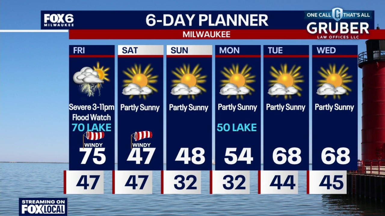
All eyes turn to Friday afternoon and evening, when the atmosphere really loads up for more strong to severe storms across Wisconsin. There are a lot of moving parts here, but the setup supports everything from large hail and damaging winds to a few tornadoes, especially if storms can stay more isolated early on.
All eyes turn to Friday afternoon and evening, when the atmosphere really loads up for more strong to severe storms across Wisconsin. There are a lot of moving parts here, but the setup supports everything from large hail and damaging winds to a few tornadoes, especially if storms can stay more isolated early on.
Weather webcast with Rob Haswell
We start off quiet but messy, with dense fog , then all eyes turn to Friday afternoon and evening, when the atmosphere really loads up for more strong to severe storms across Wisconsin.
We start off quiet but messy, with dense fog , then all eyes turn to Friday afternoon and evening, when the atmosphere really loads up for more strong to severe storms across Wisconsin.
Weather Webcast with Chief Meteorologist Tom Wachs
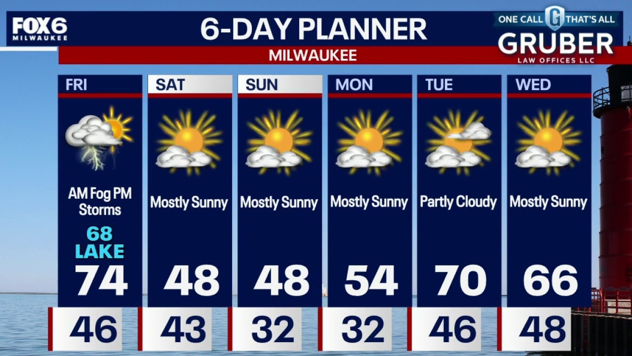
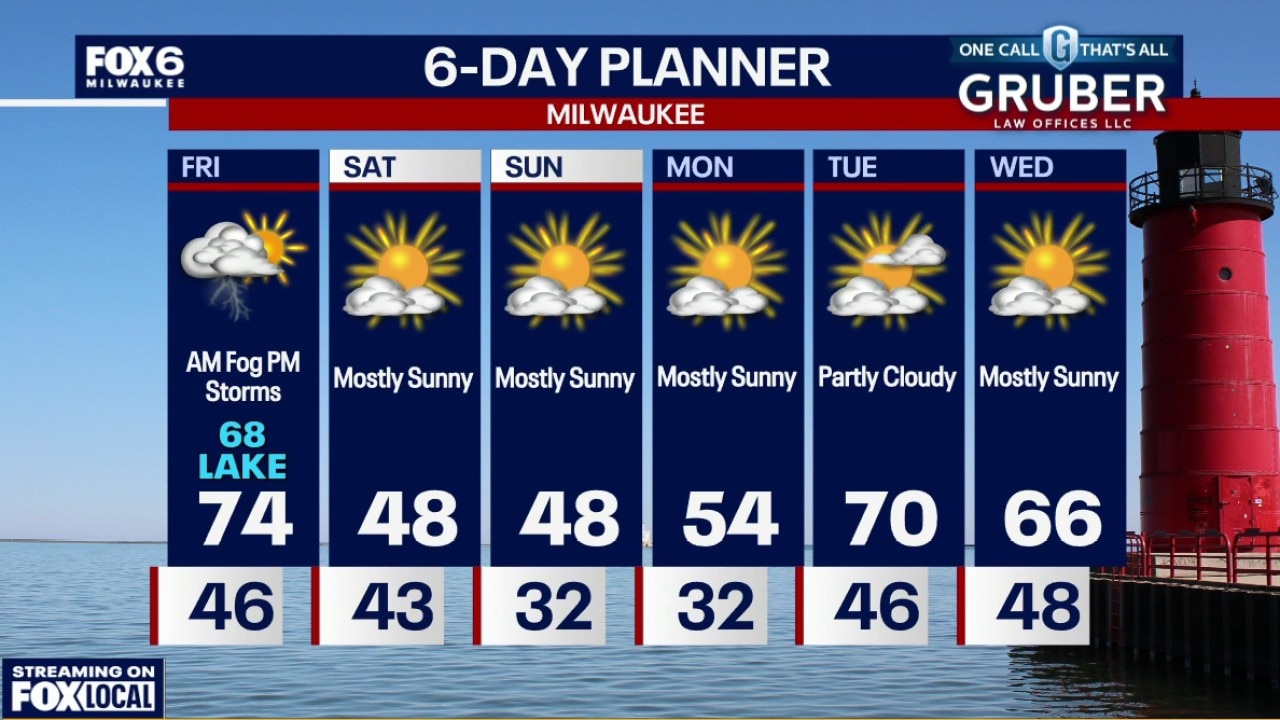
Dense Fog Advisory for Milwaukee, Ozaukee, Sheboygan, Washington, Waukesha, Racine and Kenosha counties until 9am. Flood Watch ALL OF SE WI From 1pm Friday to 7am Saturday
Dense Fog Advisory for Milwaukee, Ozaukee, Sheboygan, Washington, Waukesha, Racine and Kenosha counties until 9am. Flood Watch ALL OF SE WI From 1pm Friday to 7am Saturday
Weather webcast with meteorologist Stephanie Barichello
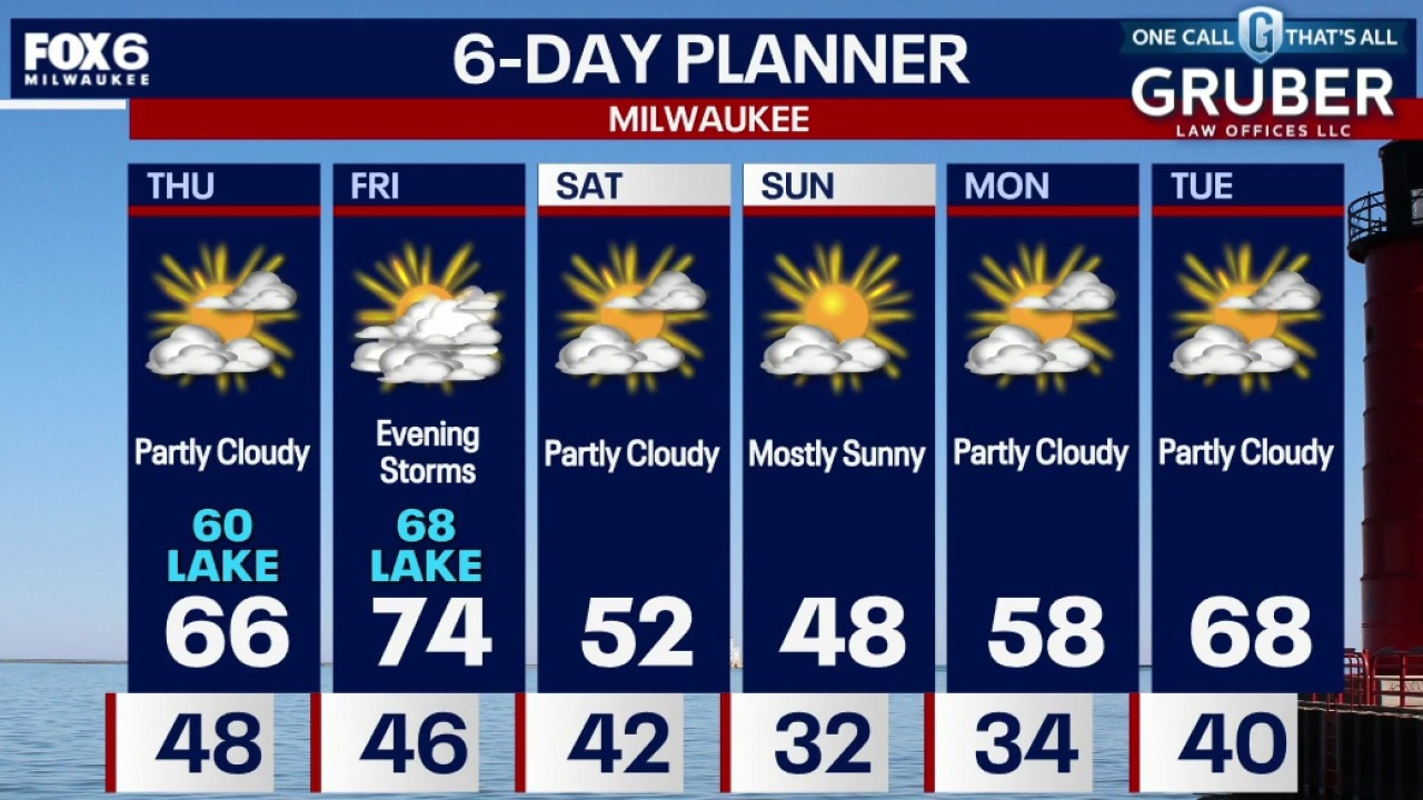
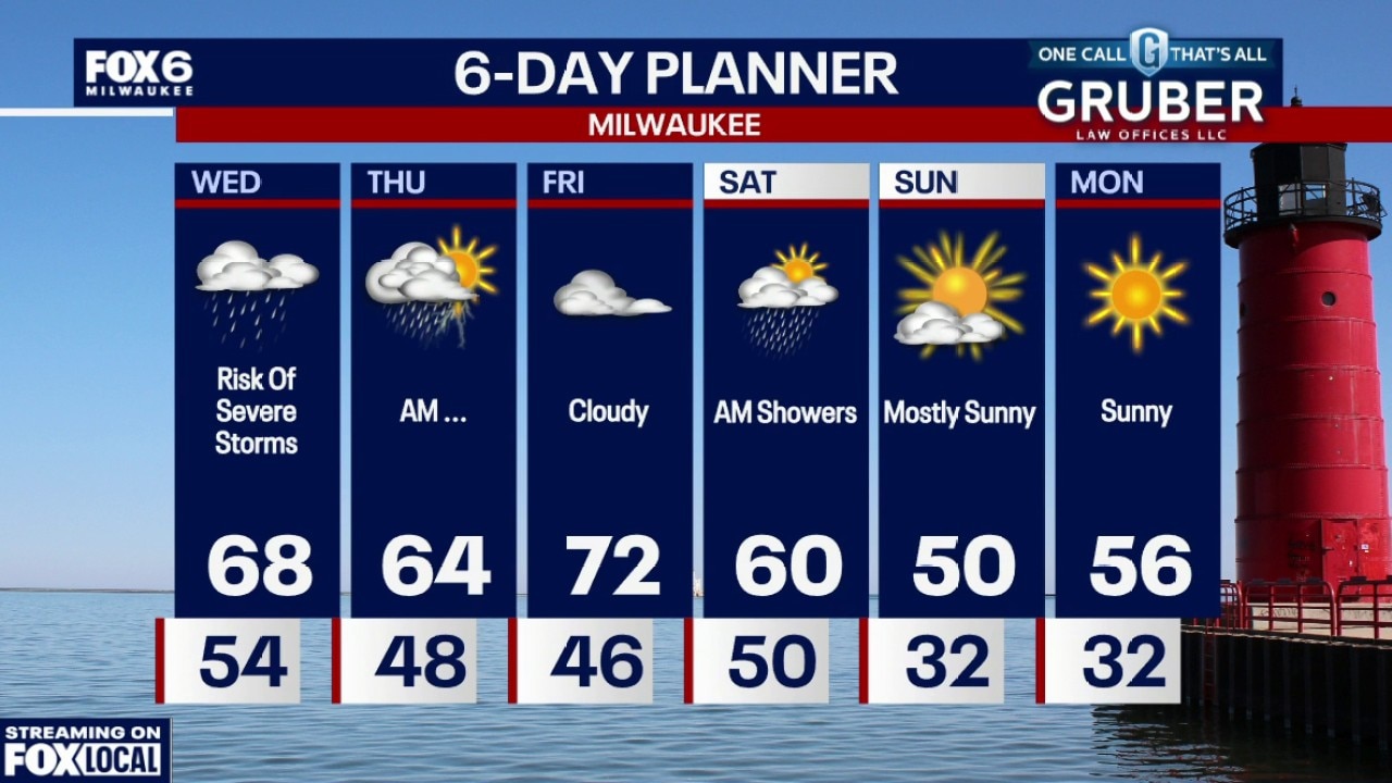
We get a break from the storms on Thursday and start to dry out, although flooding continues to be an issue. Storms, possibly severe, will return later on Friday.
We get a break from the storms on Thursday and start to dry out, although flooding continues to be an issue. Storms, possibly severe, will return later on Friday.
Weather webcast with Rob Haswell
An active and moisture-rich pattern continues across southern Wisconsin, with periods of showers and thunderstorms lingering into today along with ongoing flooding concerns.
An active and moisture-rich pattern continues across southern Wisconsin, with periods of showers and thunderstorms lingering into today along with ongoing flooding concerns.
Weather Webcast with Chief Meteorologist Tom Wachs
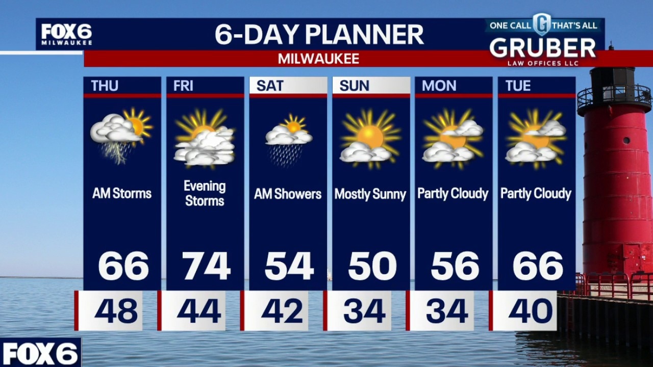
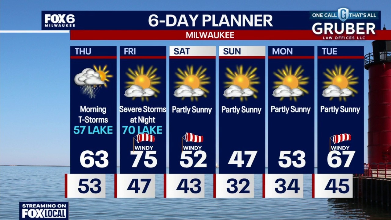
Flood Watch ALL OF SE WI until 7am Thursday Severe t-storms are possible from roughly 7pm-1am. Heavy rain, hail and wind are the main threats, however an isolated tornado can't be ruled out. 1-2" of rain expected with additional flooding possible.
Flood Watch ALL OF SE WI until 7am Thursday Severe t-storms are possible from roughly 7pm-1am. Heavy rain, hail and wind are the main threats, however an isolated tornado can't be ruled out. 1-2" of rain expected with additional flooding possible.
Weather Webcast with Stephanie Barichello
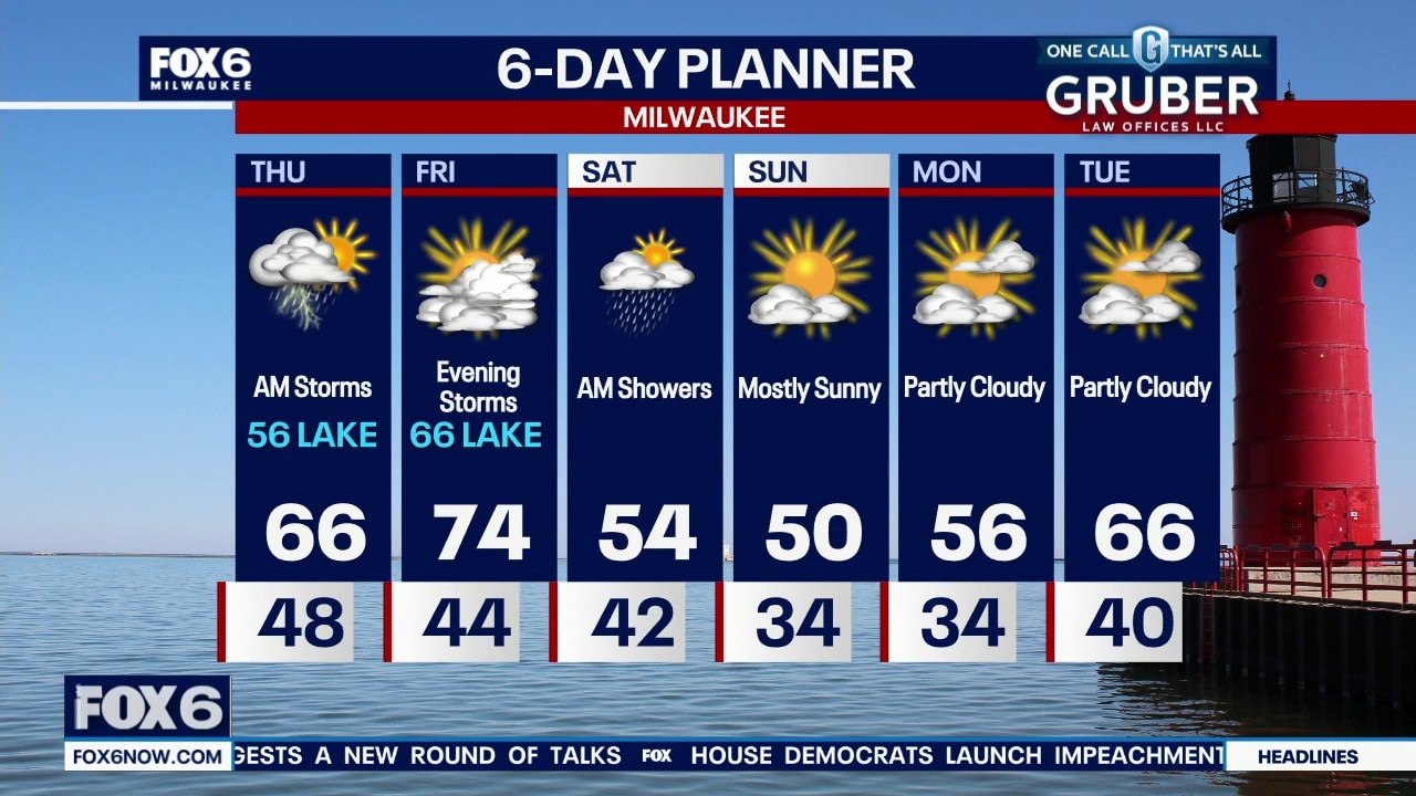
Another round of thunderstorms with heavy rain, and possibly gusty wind and hail, expected tonight into Thursday morning. Drying out later Thursday then another line of storms moves in Friday evening into Saturday morning. That line could also be severe. Finally, a dry and somewhat cooler stretch Sunday into early next week.
Another round of thunderstorms with heavy rain, and possibly gusty wind and hail, expected tonight into Thursday morning. Drying out later Thursday then another line of storms moves in Friday evening into Saturday morning. That line could also be severe. Finally, a dry and somewhat cooler stretch Sunday into early next week.
Weather webcast with Rob Haswell
An active and complex weather pattern continues across southern Wisconsin, with both severe weather and flooding concerns evolving through midweek.
An active and complex weather pattern continues across southern Wisconsin, with both severe weather and flooding concerns evolving through midweek.
Weather webcast with Stephanie Barichello
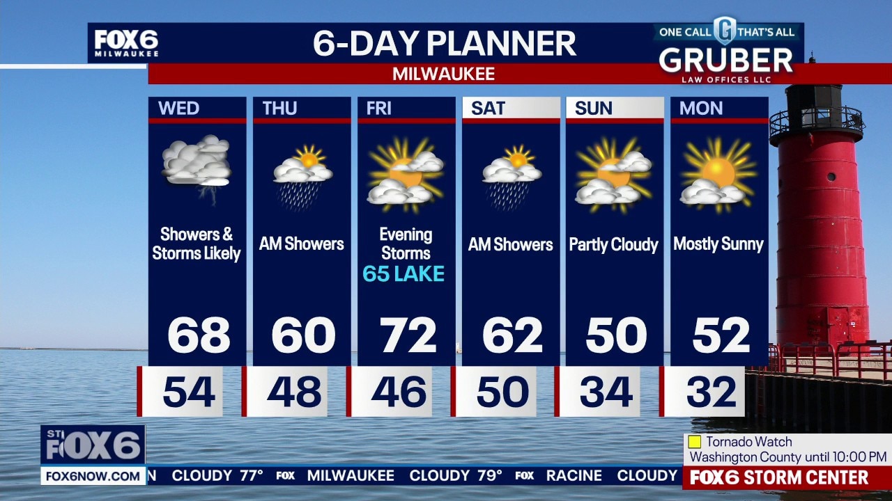
A Tornado Watch is in effect until 10pm for all of SE WI. Isolated to scattered supercells are expected between 4pm and midnight and may produce strong tornadoes, damaging wind over 70mph and large hail of 2-3" in diameter.
A Tornado Watch is in effect until 10pm for all of SE WI. Isolated to scattered supercells are expected between 4pm and midnight and may produce strong tornadoes, damaging wind over 70mph and large hail of 2-3" in diameter.