

Weather Webcast with Stephanie Barichello
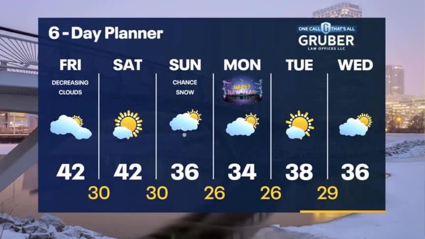
Rain and some wintry mix inland will come to an end tonight, then decreasing clouds on Friday. Chance for flurries or some light snow on New Year's Eve then chilly but dry on New Year's Day.
Rain and some wintry mix inland will come to an end tonight, then decreasing clouds on Friday. Chance for flurries or some light snow on New Year's Eve then chilly but dry on New Year's Day.
Weather webcast with Rob Haswell
A wet morning with rain showers and snow showers across our area as a low retrogrades across the western lakes. As we warm this afternoon we'll change over to all rain but snow may mix back in as we cool this evening an overnight. After a few early showers on Friday morning we dry up and stay dry into Saturday with highs in the low 40s. We cool down early next week but remain above average for the season.
A wet morning with rain showers and snow showers across our area as a low retrogrades across the western lakes. As we warm this afternoon we'll change over to all rain but snow may mix back in as we cool this evening an overnight. After a few early showers on Friday morning we dry up and stay dry into Saturday with highs in the low 40s. We cool down early next week but remain above average for the season.

Weather Webcast with Meteorologist Eric Manges
Chance of rain and snow tomorrow then cooler heading into 2024
Chance of rain and snow tomorrow then cooler heading into 2024
Weather webcast with Lisa Michaels
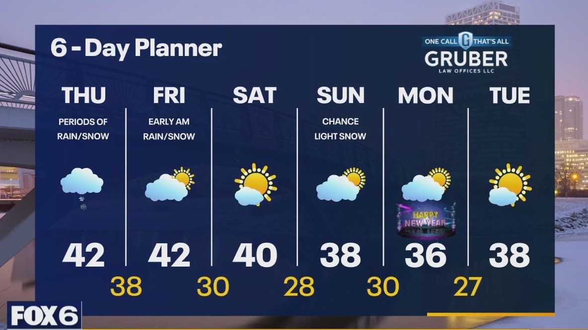
Clouds stay tonight bringing the chance of rain/snow early Thursday into Friday morning. Very minor accumulation possible inland with most areas not seeing any accumulation. Low visibility and slick spots in the early morning and night are possible. High temps remain in the upper 30s to lower 40s this week. Cooler air arrives by early next week welcoming in the new year, although we still remain above the seasonal averages.
Clouds stay tonight bringing the chance of rain/snow early Thursday into Friday morning. Very minor accumulation possible inland with most areas not seeing any accumulation. Low visibility and slick spots in the early morning and night are possible. High temps remain in the upper 30s to lower 40s this week. Cooler air arrives by early next week welcoming in the new year, although we still remain above the seasonal averages.

Weather webcast with Rob Haswell
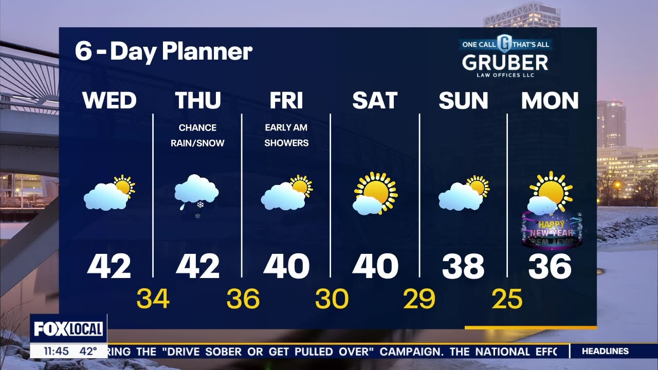
A cooler start to our day today with partly cloudy conditions. Temperatures will still warm well above average with highs reaching the low 40s. An area of low pressure over the lower Great Lakes retrogrades into our area for Thursday with showers and a chance for some snow - mostly inland. Highs will warm into the low 40s again Thursday so any light accumulation early in the day will immediately melt. Cooler air arrives by early next although we still remain above the seasonal averages.
A cooler start to our day today with partly cloudy conditions. Temperatures will still warm well above average with highs reaching the low 40s. An area of low pressure over the lower Great Lakes retrogrades into our area for Thursday with showers and a chance for some snow - mostly inland. Highs will warm into the low 40s again Thursday so any light accumulation early in the day will immediately melt. Cooler air arrives by early next although we still remain above the seasonal averages.

Weather Webcast with Meteorologist Eric Manges
Chance of rain and snow on Thursday then cooler air to end the year
Chance of rain and snow on Thursday then cooler air to end the year
Weather webcast with Lisa Michaels
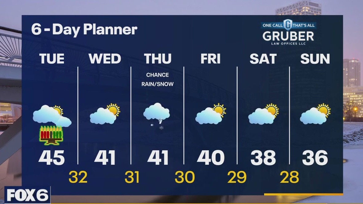
Patchy fog and drizzle. Mostly cloudy and mild in the 40s during the morning. Temperatures slowly drop into the upper 30s to low 40s for highs under mostly cloudy skies. Next chance of rain/snow could clip us on Thursday. More seasonable temps end the month and welcome the new year.
Patchy fog and drizzle. Mostly cloudy and mild in the 40s during the morning. Temperatures slowly drop into the upper 30s to low 40s for highs under mostly cloudy skies. Next chance of rain/snow could clip us on Thursday. More seasonable temps end the month and welcome the new year.

Weather Webcast with Meteorologist Eric Manges
Rain ending tonight then cooler air moving in tomorrow
Rain ending tonight then cooler air moving in tomorrow
Weather webcast with Lisa Michaels
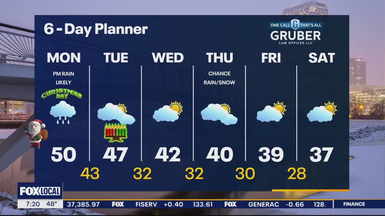
Patchy fog and cloudy in the morning. Mild temps in the upper 40s to low 50s. Cloudy Christmas Day with rain starting mostly in the afternoon then rain potential continues through Tuesday morning.
Patchy fog and cloudy in the morning. Mild temps in the upper 40s to low 50s. Cloudy Christmas Day with rain starting mostly in the afternoon then rain potential continues through Tuesday morning.

Weather Webcast with Meteorologist Eric Manges
Staying warm and rainy Christmas Day then cooling temperatures to end the week
Staying warm and rainy Christmas Day then cooling temperatures to end the week
Weather webcast with Rob Haswell
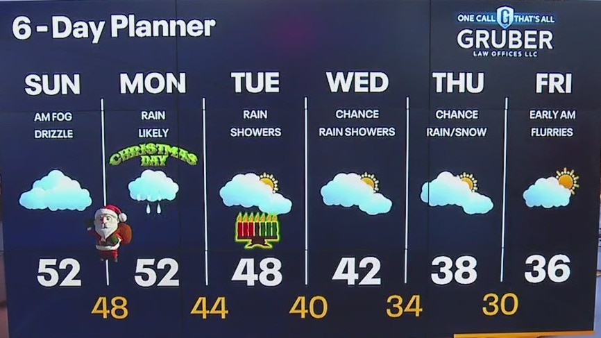
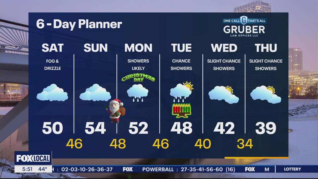
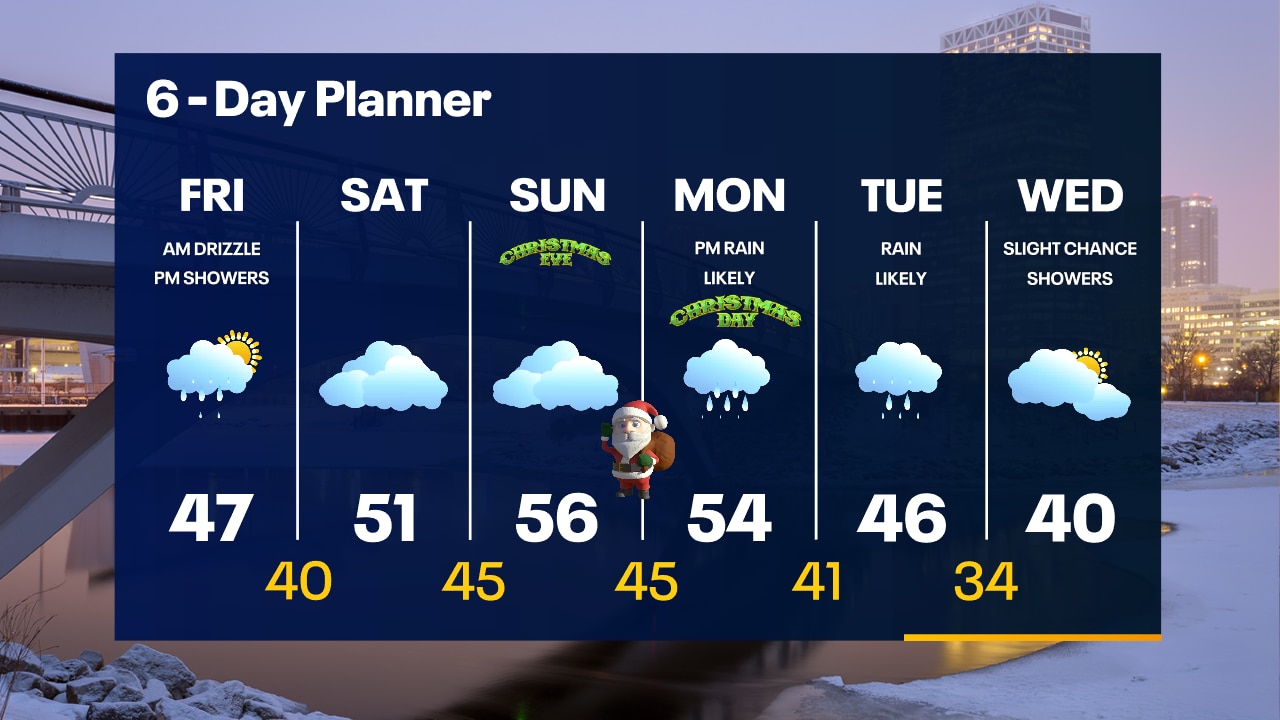
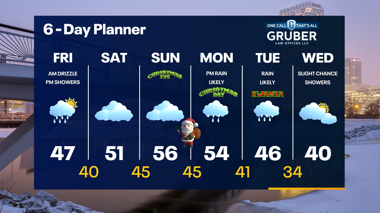
Dense fog advisory until 9 a.m., take care on area roads. Very mild today with highs in the low 50s likely. Patchy drizzle a times. A low arrives overnight with rain arriving for Christmas Day. Most areas will see around 0.5" Cold air and a chance for some light snow arrives late next week.
Dense fog advisory until 9 a.m., take care on area roads. Very mild today with highs in the low 50s likely. Patchy drizzle a times. A low arrives overnight with rain arriving for Christmas Day. Most areas will see around 0.5" Cold air and a chance for some light snow arrives late next week.

Weather Webcast with Meteorologist Eric Manges
Rainy and warm as we ring in Christmas day especially in the afternoon
Rainy and warm as we ring in Christmas day especially in the afternoon
Weather webcast with Rob Haswell
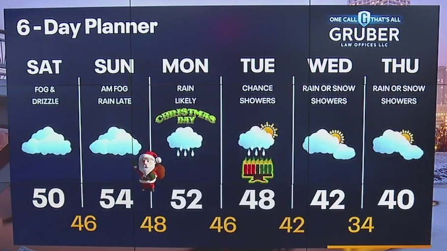
Dense Fog Advisory today until 11am. Visibility in many areas will be below 0.25 mi. Drive with extra care and caution. We stay mild and damp today but should get a break from the steadier rain with only a few sprinkles or drizzle at times. Highs today will be near 50 and warm to the low 50s tomorrow and Christmas Day Monday.
Dense Fog Advisory today until 11am. Visibility in many areas will be below 0.25 mi. Drive with extra care and caution. We stay mild and damp today but should get a break from the steadier rain with only a few sprinkles or drizzle at times. Highs today will be near 50 and warm to the low 50s tomorrow and Christmas Day Monday.

Weather Webcast with Meteorologist Eric Manges
Cloudy and warm for the weekend with another round of rain on Christmas day
Cloudy and warm for the weekend with another round of rain on Christmas day
Weather Webcast with Meteorologist Eric Manges
Warm and rainy will be the theme heading into Christmas this year
Warm and rainy will be the theme heading into Christmas this year
Weather Webcast with Stephanie Barichello
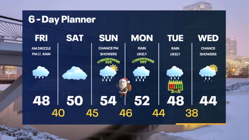
Cloudy with rain showers today, ending late tonight. Expect some patchy fog and drizzle at times tonight and Saturday, but still mild tomorrow around 50. A bigger and slower system brings rain again Sunday evening, which will likely linger through Wednesday of next week.
Cloudy with rain showers today, ending late tonight. Expect some patchy fog and drizzle at times tonight and Saturday, but still mild tomorrow around 50. A bigger and slower system brings rain again Sunday evening, which will likely linger through Wednesday of next week.
Weather webcast with Rob Haswell
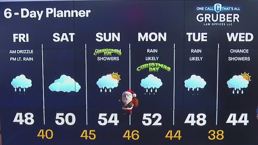
A cloudy and wet stretch begins today with steady light rain likely by midday and through the afternoon and early evening. Rain returns Sunday and into Christmas Day Monday with more rain possible Tuesday and Wednesday. The next few days will also be seasonally mild with highs in the upper 40s and low to mid 50s.
A cloudy and wet stretch begins today with steady light rain likely by midday and through the afternoon and early evening. Rain returns Sunday and into Christmas Day Monday with more rain possible Tuesday and Wednesday. The next few days will also be seasonally mild with highs in the upper 40s and low to mid 50s.
Weather Webcast with Tom Wachs
Patchy drizzle overnight with temperatures around 40. Steady rain will move in from the southwest around 3pm and continue Friday night. Highs in the 40s.
Patchy drizzle overnight with temperatures around 40. Steady rain will move in from the southwest around 3pm and continue Friday night. Highs in the 40s.
Weather Webcast with Tom Wachs
Cloudy with patchy drizzle tonight. Temperatures holding steady around 40. Morning drizzle will give way to a batch of rain later in the afternoon and evening, especially south of Milwaukee.
Cloudy with patchy drizzle tonight. Temperatures holding steady around 40. Morning drizzle will give way to a batch of rain later in the afternoon and evening, especially south of Milwaukee.

Weather webcast with Rob Haswell
Another mild day today with highs in the low to mid 40s likely. A few showers are possible later this afternoon and evening as a developing warm front moves our way.
Another mild day today with highs in the low to mid 40s likely. A few showers are possible later this afternoon and evening as a developing warm front moves our way.