

Weather Webcast with Tom Wachs
Dense fog overnight with temperatures in the upper 20s to low 30s. Freezing drizzle is possible inland on Wednesday morning with a steadier batch of rain between 9am-3pm.
Dense fog overnight with temperatures in the upper 20s to low 30s. Freezing drizzle is possible inland on Wednesday morning with a steadier batch of rain between 9am-3pm.
Weather Webcast with Tom Wachs
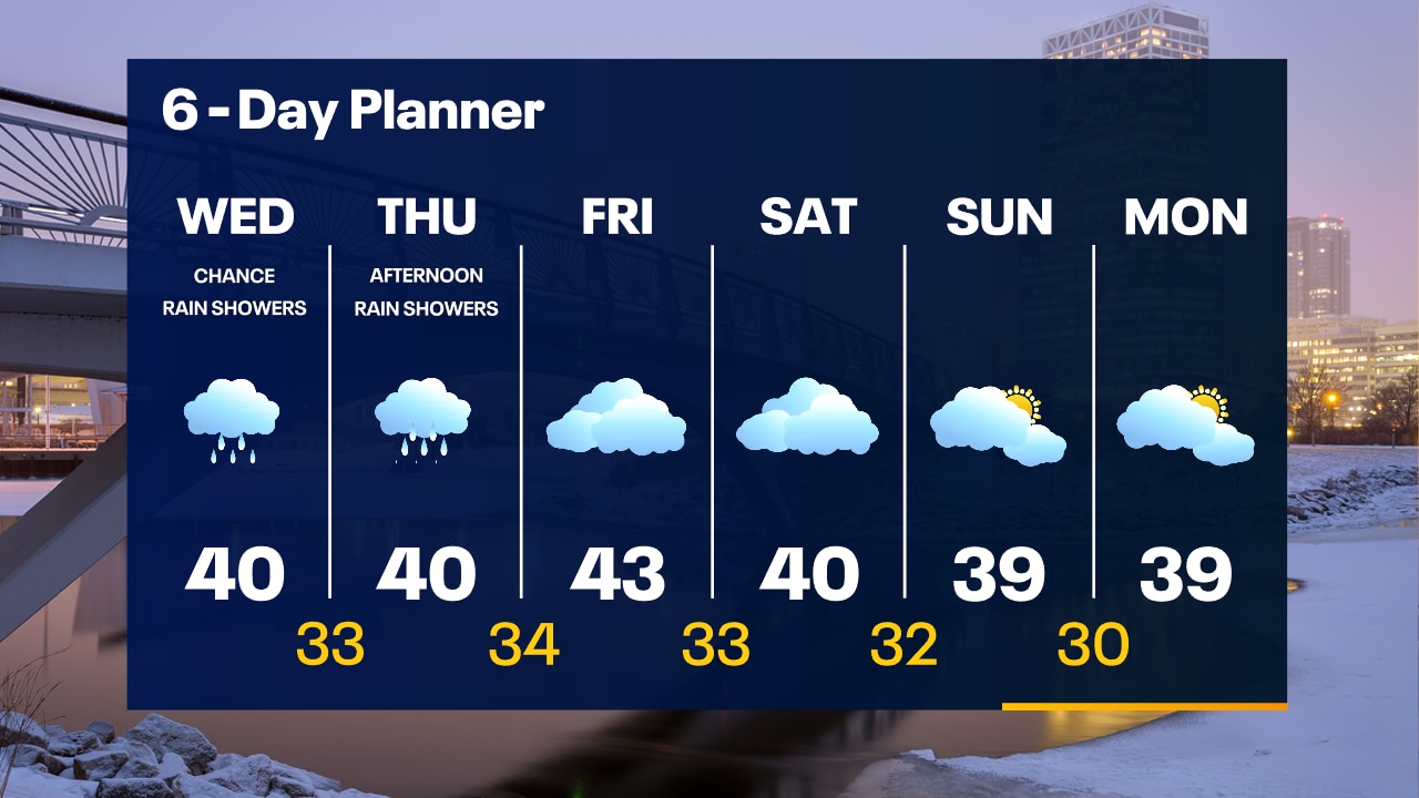
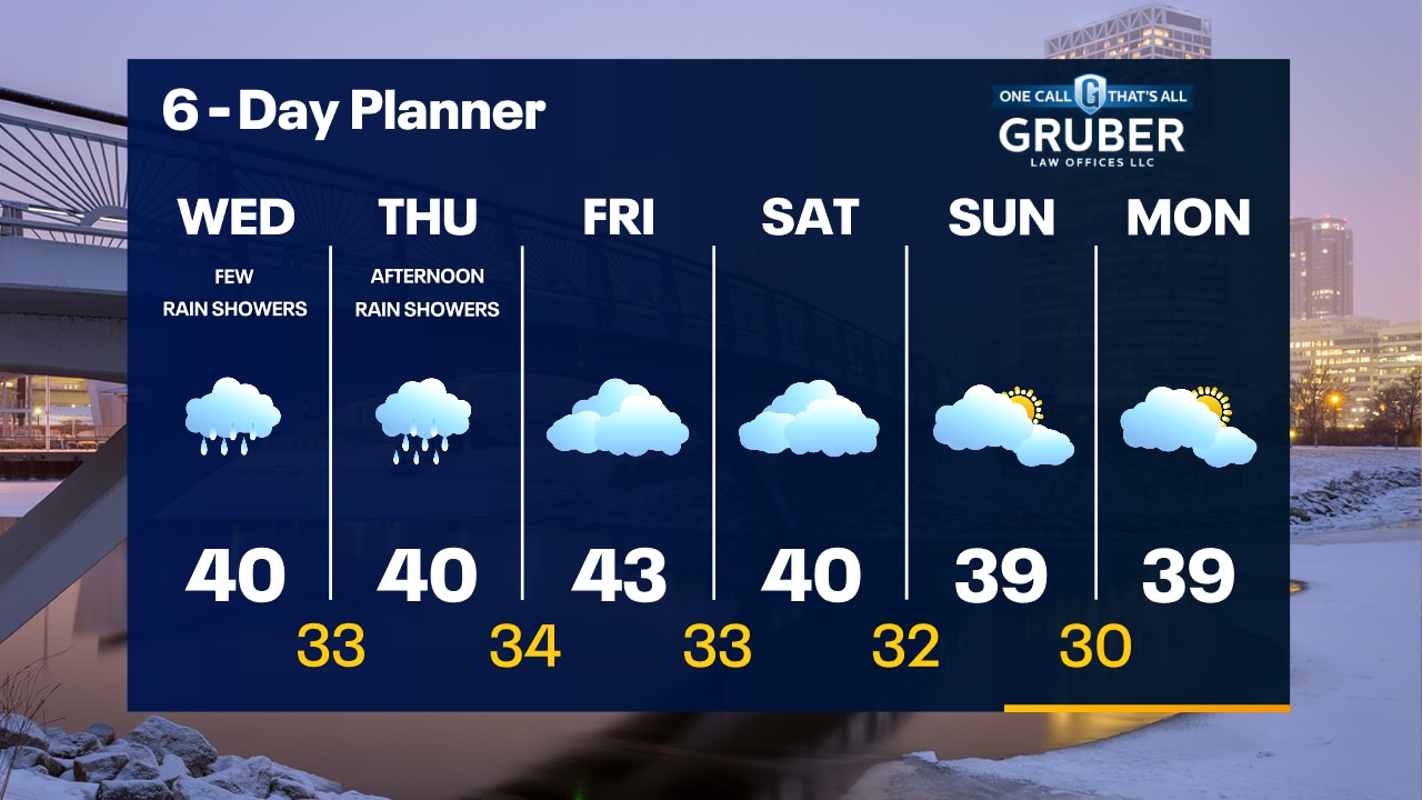
Dense Fog Advisory tonight. Foggy with temperatures around or just below freezing overnight. Patchy freezing drizzle away from the lake by morning. Patchy light rain showers Wednesday with a high around 40.
Dense Fog Advisory tonight. Foggy with temperatures around or just below freezing overnight. Patchy freezing drizzle away from the lake by morning. Patchy light rain showers Wednesday with a high around 40.
Weather webcast with Rob Haswell
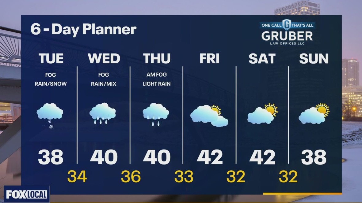
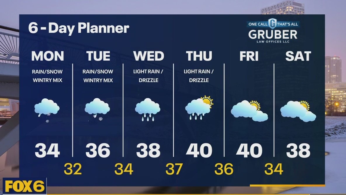
A Winter Weather Advisory covers most of Southeastern Wisconsin today with rain, snow, freezing rain and sleet expected. A slushy inch or two is possible. We will start as rain and a wintry mix and transition to snow by mid-day. The snow will be wet and likely end by early evening. Fog will be an issue today, tonight and again Wednesday into Thursday morning. Reduced visibility will be challenging at times. More rain is expected Wednesday and Thursday but we dry up Friday and into the weekend. We remain very mild all week.
A Winter Weather Advisory covers most of Southeastern Wisconsin today with rain, snow, freezing rain and sleet expected. A slushy inch or two is possible. We will start as rain and a wintry mix and transition to snow by mid-day. The snow will be wet and likely end by early evening. Fog will be an issue today, tonight and again Wednesday into Thursday morning. Reduced visibility will be challenging at times. More rain is expected Wednesday and Thursday but we dry up Friday and into the weekend. We remain very mild all week.
Weather webcast with Lisa Michaels
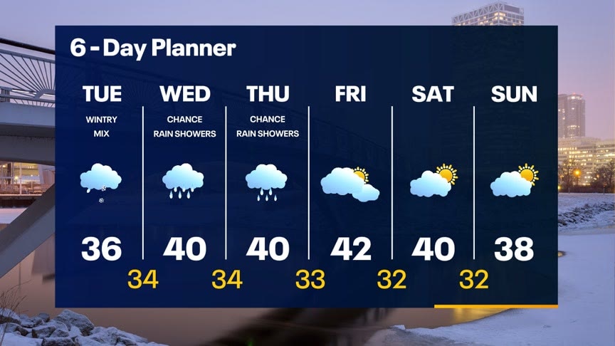
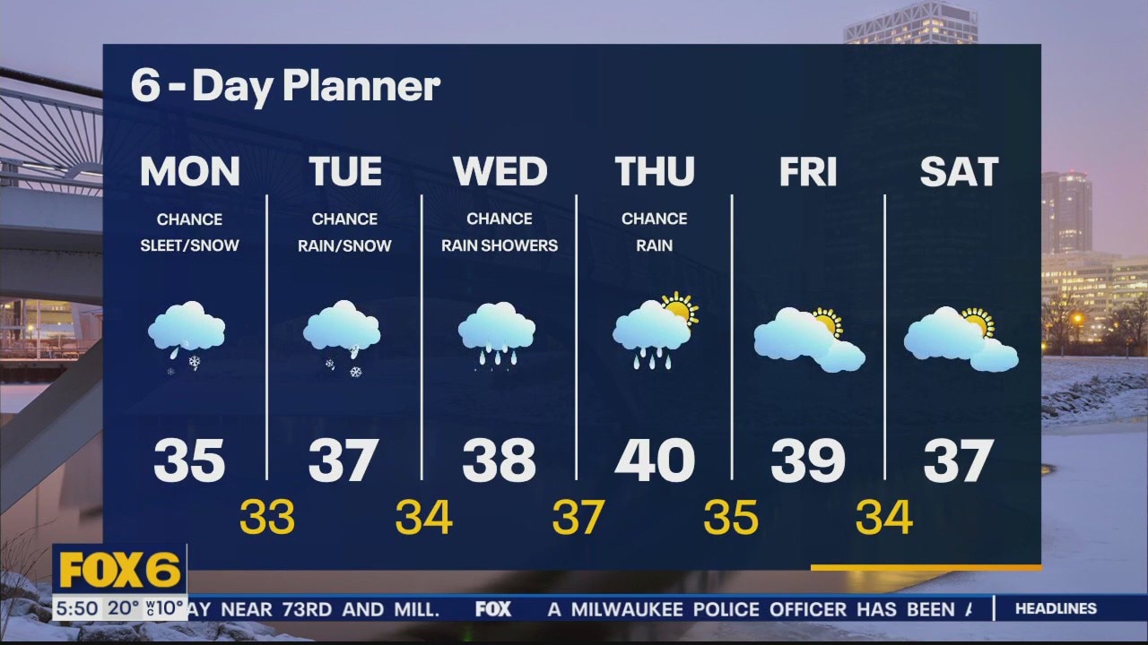
Dry this evening with temperatures only dropping into the low 30s overnight. Winter weather advisory begins at 2am to 6am through 2pm Tuesday. Expect a messy morning Tuesday with potential freezing rain, sleet and slushy snow. Up to 0.10" of ice possible, along with a few inches of snow. Rain/snow mix will end Tuesday evening, then a period of rain is expected Wednesday and Thursday. Both days will be around 40?. Drying out this weekend with a few clouds and staying unseasonably mild.
Dry this evening with temperatures only dropping into the low 30s overnight. Winter weather advisory begins at 2am to 6am through 2pm Tuesday. Expect a messy morning Tuesday with potential freezing rain, sleet and slushy snow. Up to 0.10" of ice possible, along with a few inches of snow. Rain/snow mix will end Tuesday evening, then a period of rain is expected Wednesday and Thursday. Both days will be around 40?. Drying out this weekend with a few clouds and staying unseasonably mild.
Weather webcast with Rob Haswell
A push of warm air is also bringing more moisture. We can expect temperatures to warm into the mid to upper 30s over the next couple of days. The additional moisture brings periods of wet snow, drizzle and freezing rain and sleet. Area roads will be very challenging at times. We warm to near 40 late week and the active precipitation tapers off. However, a great deal of melting will lead to concerns for river flooding and ponding on some areas will blocked or poor drainage.
A push of warm air is also bringing more moisture. We can expect temperatures to warm into the mid to upper 30s over the next couple of days. The additional moisture brings periods of wet snow, drizzle and freezing rain and sleet. Area roads will be very challenging at times. We warm to near 40 late week and the active precipitation tapers off. However, a great deal of melting will lead to concerns for river flooding and ponding on some areas will blocked or poor drainage.
Weather Webcast with Meteorologist Eric Manges
Getting warmer this week with multiple rain/snow chances
Getting warmer this week with multiple rain/snow chances
Weather Webcast with Stephanie Barichello
Our last cold, sunny day today then clouds and warmer air arrive Monday. There is a chance for some morning snow/sleet then a more widespread area of rain/snow impacts us Monday night through Tuesday. A few inches of slush will be possible along with a glaze of ice. Rain and 40s by Wednesday.
Our last cold, sunny day today then clouds and warmer air arrive Monday. There is a chance for some morning snow/sleet then a more widespread area of rain/snow impacts us Monday night through Tuesday. A few inches of slush will be possible along with a glaze of ice. Rain and 40s by Wednesday.
Weather webcast with Stephanie Barichello
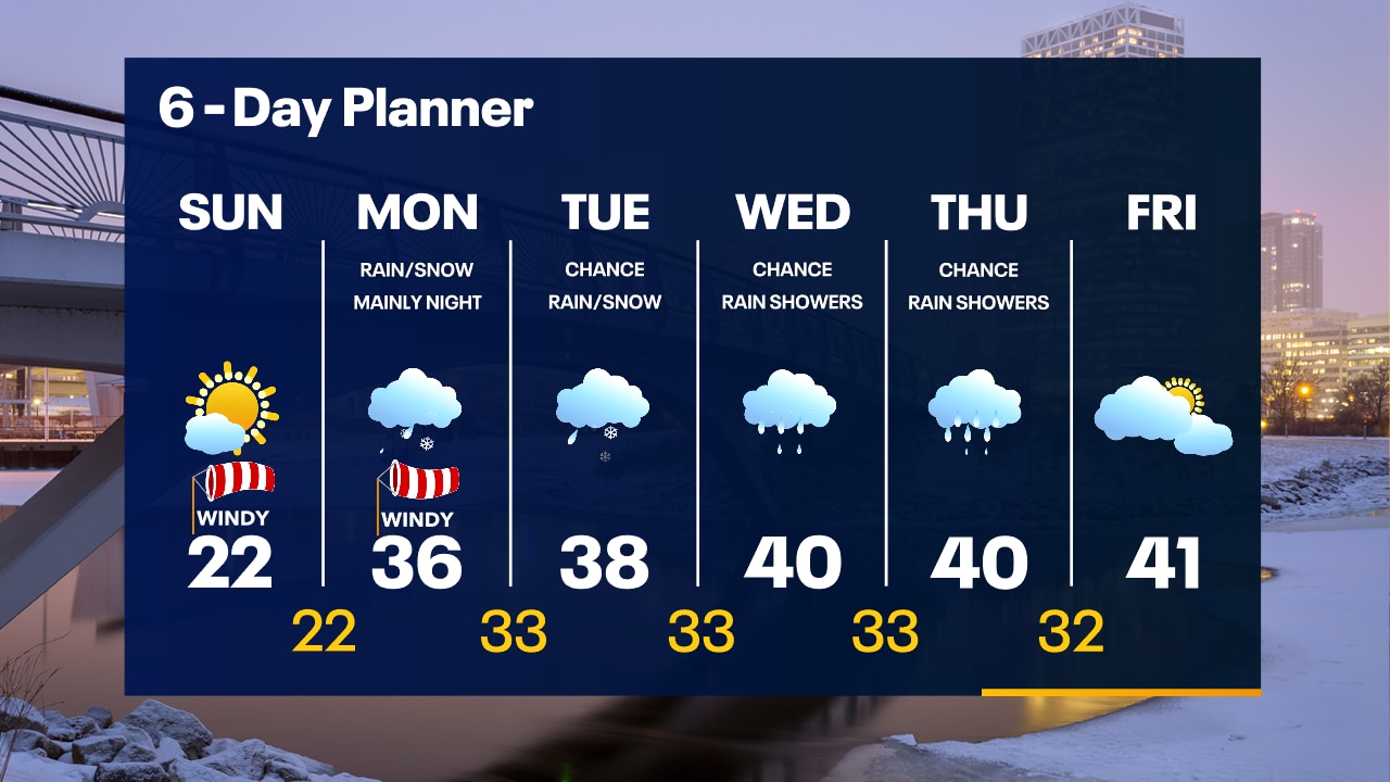
Another sunny and chilly day today with temperatures in the low 20s and wind chills between 0 and +10?. Rising temperatures tonight, which will bring us into the 30s on Monday. There is a chance for sleet and snow on Monday, plus windy, so messy at times. There is a chance for slushy snow and some rain Monday night into Tuesday. It's possible some still pick up a few inches of heavy, wet snow but also see some rain.
Another sunny and chilly day today with temperatures in the low 20s and wind chills between 0 and +10?. Rising temperatures tonight, which will bring us into the 30s on Monday. There is a chance for sleet and snow on Monday, plus windy, so messy at times. There is a chance for slushy snow and some rain Monday night into Tuesday. It's possible some still pick up a few inches of heavy, wet snow but also see some rain.

Weather Webcast with Tom Wachs
Wind Chill Advisory until 9am. Morning wind chills between -20 and -25. Mostly sunny and windy on Sunday with highs in the low 20s. Temperatures will warm above freezing on Monday.
Wind Chill Advisory until 9am. Morning wind chills between -20 and -25. Mostly sunny and windy on Sunday with highs in the low 20s. Temperatures will warm above freezing on Monday.
Weather Webcast with Tom Wachs
Wind Chill Advisory overnight. Morning wind chills between -20 and -25. Mostly sunny on Sunday and windy with highs in the low 20s. Warming up on Monday.
Wind Chill Advisory overnight. Morning wind chills between -20 and -25. Mostly sunny on Sunday and windy with highs in the low 20s. Warming up on Monday.

Weather webcast with Stephanie Barichello
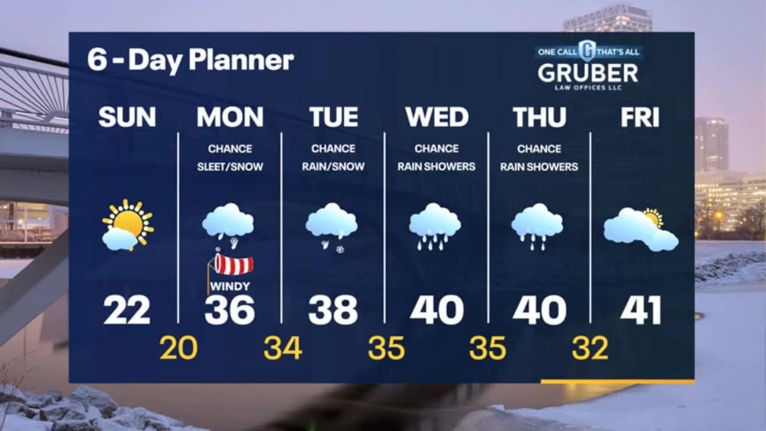
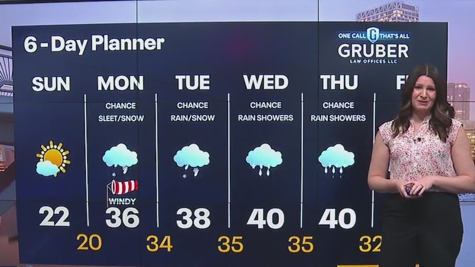
Mostly sunny but cold again today with temperatures in the teens and wind chills between -5 and +5. Wind chills drop into the teens and 20s below 0 tonight. A few more clouds Sunday and closer to 20, then jumping into the 30s on Monday. There is a chance for rain/snow showers Monday and Tuesday, although it may become all rain in spots by Tuesday afternoon.
Mostly sunny but cold again today with temperatures in the teens and wind chills between -5 and +5. Wind chills drop into the teens and 20s below 0 tonight. A few more clouds Sunday and closer to 20, then jumping into the 30s on Monday. There is a chance for rain/snow showers Monday and Tuesday, although it may become all rain in spots by Tuesday afternoon.

Weather Webcast with Meteorologist Eric Manges
Cold air into the weekend then a warm up next week but a messy Tuesday
Cold air into the weekend then a warm up next week but a messy Tuesday
Weather webcast with Rob Haswell
A trough of low pressure continues to impact the area with very light snow. Around an inch of very light snow on area roads this morning with lingering flurries later today and tonight. High pressure returns tomorrow with ample sunshine but we remain chilly. Highs today and Saturday will be in the mid to upper teens. We start warming on Sunday with mostly sunny conditions and a more favorable southwest wind developing. However, the big warm up comes next week as we get into the upper 30s to near 40.
A trough of low pressure continues to impact the area with very light snow. Around an inch of very light snow on area roads this morning with lingering flurries later today and tonight. High pressure returns tomorrow with ample sunshine but we remain chilly. Highs today and Saturday will be in the mid to upper teens. We start warming on Sunday with mostly sunny conditions and a more favorable southwest wind developing. However, the big warm up comes next week as we get into the upper 30s to near 40.
Weather Webcast with Tom Wachs
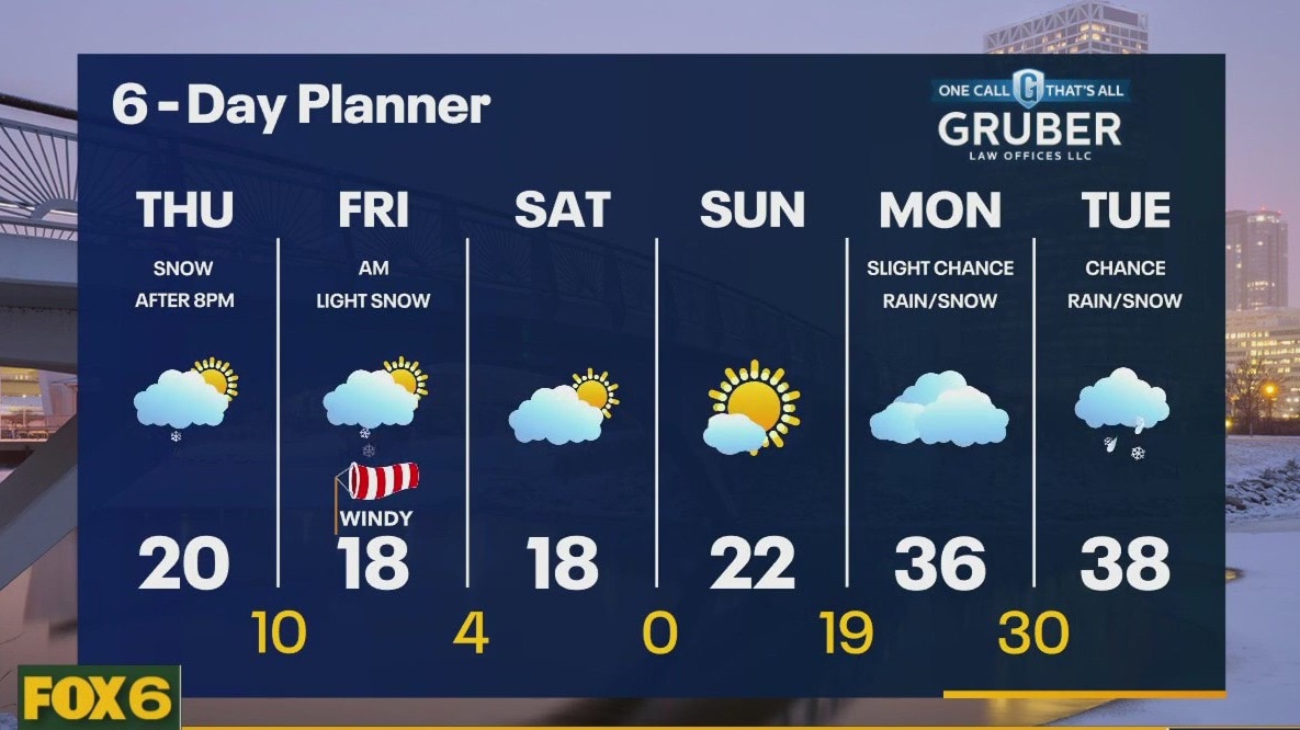
Light snow overnight. Less than 1" most areas, 1-2" along the IL border. Snow ends by 5am. Scattered snow showers near the lake on Friday with highs in the teens and wind chills between 0 and -10.
Light snow overnight. Less than 1" most areas, 1-2" along the IL border. Snow ends by 5am. Scattered snow showers near the lake on Friday with highs in the teens and wind chills between 0 and -10.
Weather Webcast with Tom Wachs
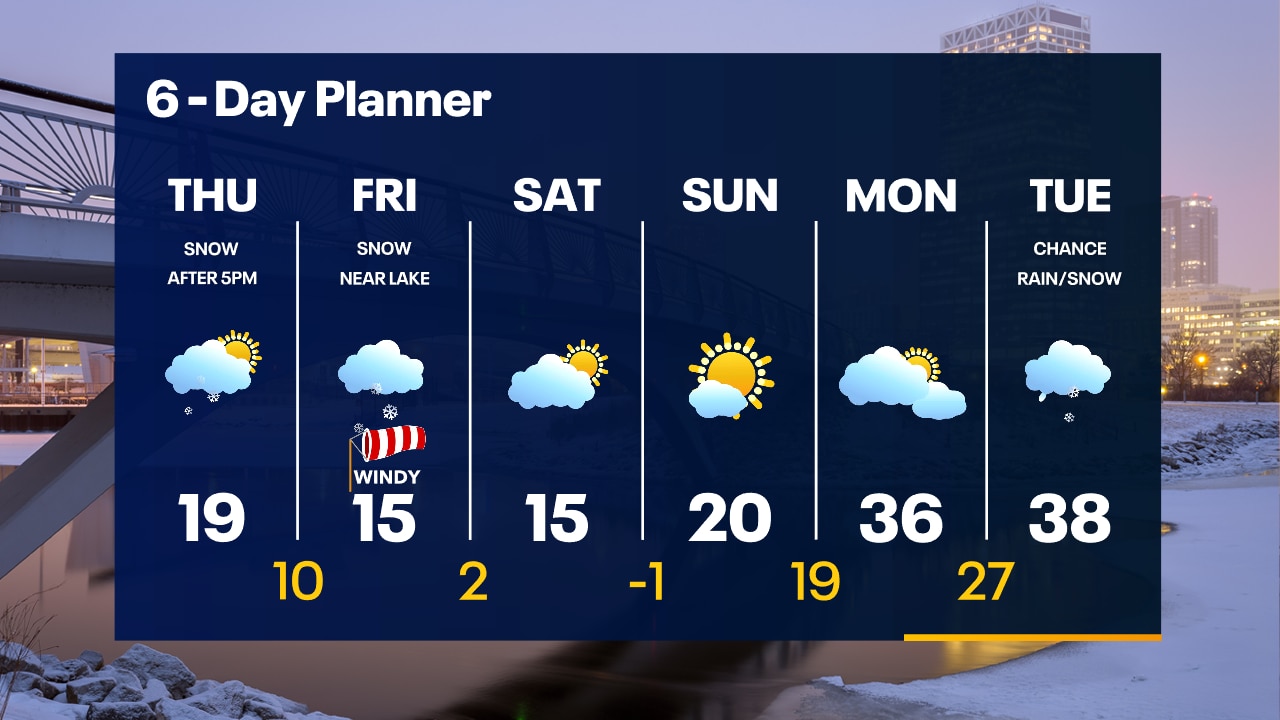
Light snow moving in this evening and moving out around sunrise. Less than 1" north of Milwaukee, around 1" in Milwaukee and 1-2" south. A few snow showers near the lake Friday, with a windy high around 16.
Light snow moving in this evening and moving out around sunrise. Less than 1" north of Milwaukee, around 1" in Milwaukee and 1-2" south. A few snow showers near the lake Friday, with a windy high around 16.
Weather webcast with Rob Haswell
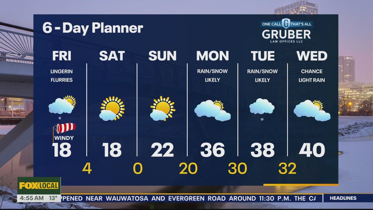
Some light snow this morning for areas close to the IL state line will wrap up and the remainder of the day will be mostly cloudy, dry and not quite as cold. Highs today will reach the upper teens and low 20s - still well below the low 30s averages. Light snow returns as a clipper type system moves through late today into Friday. This snow will be very light and fluffy. We could see up to 2" in some areas. We stay in the upper teens and low 20s through the weekend but the big warm up arrives early next with with highs in the upper 30s to near 40. Rain and a wintry mix is possible by Tuesday.
Some light snow this morning for areas close to the IL state line will wrap up and the remainder of the day will be mostly cloudy, dry and not quite as cold. Highs today will reach the upper teens and low 20s - still well below the low 30s averages. Light snow returns as a clipper type system moves through late today into Friday. This snow will be very light and fluffy. We could see up to 2" in some areas. We stay in the upper teens and low 20s through the weekend but the big warm up arrives early next with with highs in the upper 30s to near 40. Rain and a wintry mix is possible by Tuesday.

Weather Webcast with Tom Wachs
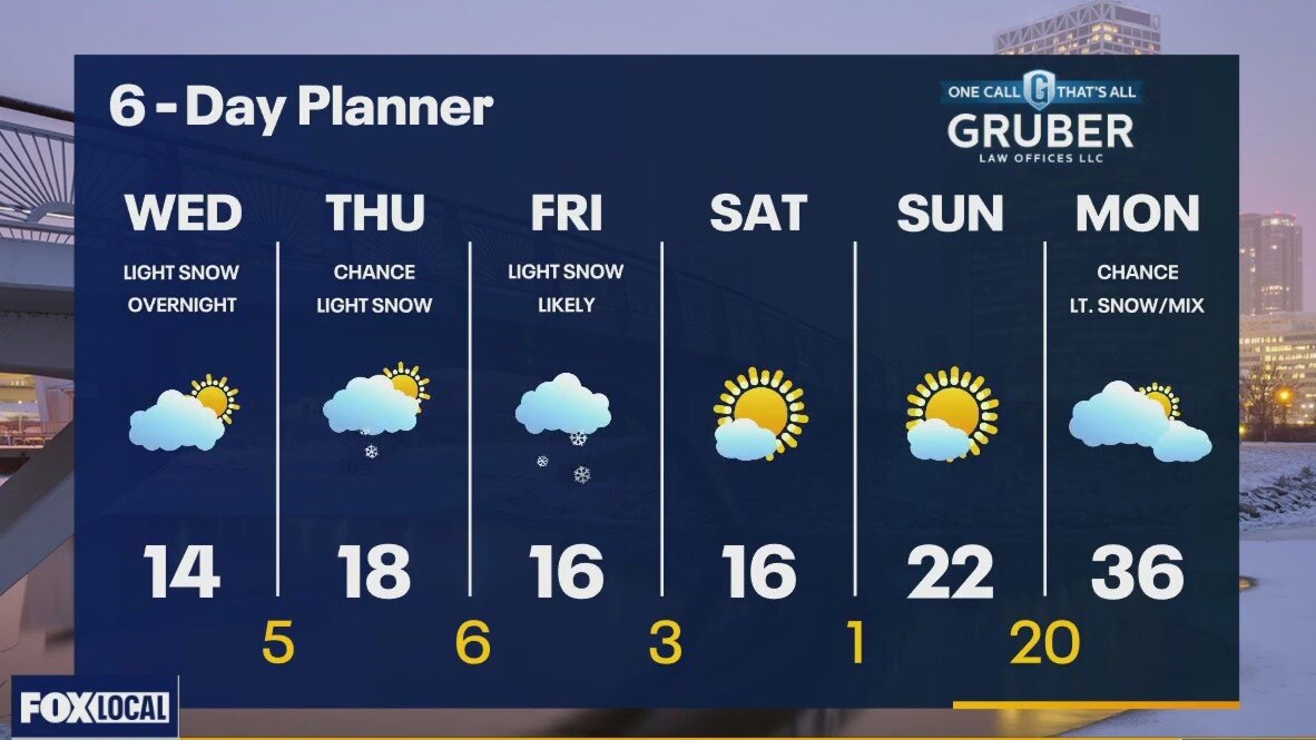
Mostly cloudy on Thursday with highs in the teens. Snow moves in from the west after 5-6pm. 1-3" of snow likely on Thursday night.
Mostly cloudy on Thursday with highs in the teens. Snow moves in from the west after 5-6pm. 1-3" of snow likely on Thursday night.
Weather Webcast with Tom Wachs
Increasing clouds tonight with steady temperatures in the single digits/teens. Mostly cloudy on Thursday with snow moving in after 5pm. 1-3" of snow possible Thursday night/early Friday.
Increasing clouds tonight with steady temperatures in the single digits/teens. Mostly cloudy on Thursday with snow moving in after 5pm. 1-3" of snow possible Thursday night/early Friday.

Weather Webcast with Meteorologist Eric Manges
Staying cold but an improvement from the beginning of the week as we cruise into the weekend
Staying cold but an improvement from the beginning of the week as we cruise into the weekend
Weather webcast with Rob Haswell
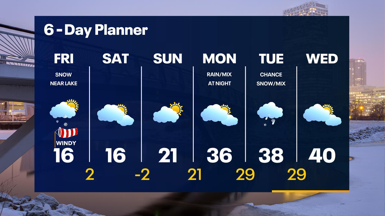
Wind Chill Advisory for all of SE WI until 9am today. Another cold start but we do warm very slightly today with a high in the low to mid teens. It will feel colder with a steady SW wind 10-15mph. A few flakes are possible overnight tonight with the most likely spots being areas south of I-94 toward the state line. Another round of light, fluffy snow is expected Thursday into Friday. A light accumulation is possible. We finally warm back to season or above by early next week.
Wind Chill Advisory for all of SE WI until 9am today. Another cold start but we do warm very slightly today with a high in the low to mid teens. It will feel colder with a steady SW wind 10-15mph. A few flakes are possible overnight tonight with the most likely spots being areas south of I-94 toward the state line. Another round of light, fluffy snow is expected Thursday into Friday. A light accumulation is possible. We finally warm back to season or above by early next week.