


Weather Webcast with Stephanie Barichello
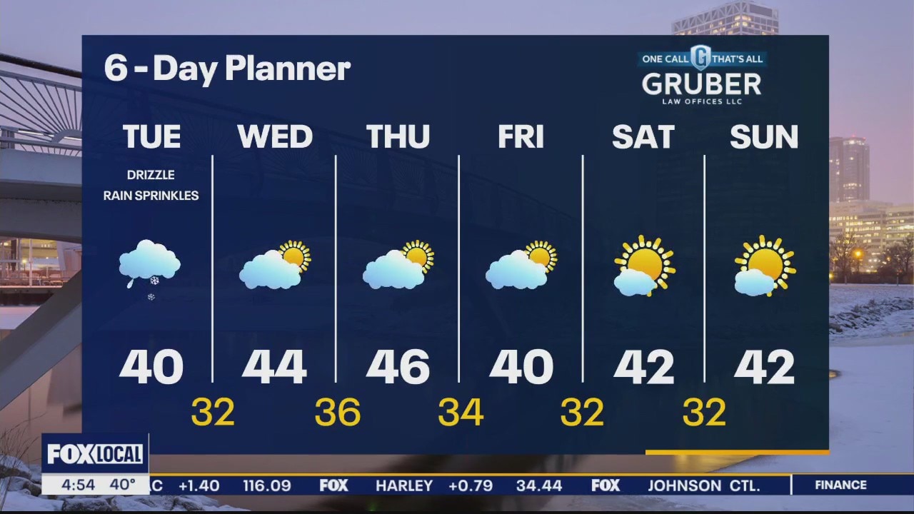
Cloudy with some sprinkles today then sunshine returns on Wednesday. Expect warmer temps in the mid 40s Wednesday and Thursday. Sunshine lasts through the weekend.
Cloudy with some sprinkles today then sunshine returns on Wednesday. Expect warmer temps in the mid 40s Wednesday and Thursday. Sunshine lasts through the weekend.
Weather webcast with Rob Haswell
A cloudy day with a weak low passing through the areas. Some drizzle or a few sprinkles possible. Temperatures remain steady in the upper 30s to near 40 most of the day.
A cloudy day with a weak low passing through the areas. Some drizzle or a few sprinkles possible. Temperatures remain steady in the upper 30s to near 40 most of the day.
Weather Webcast with Tom Wachs
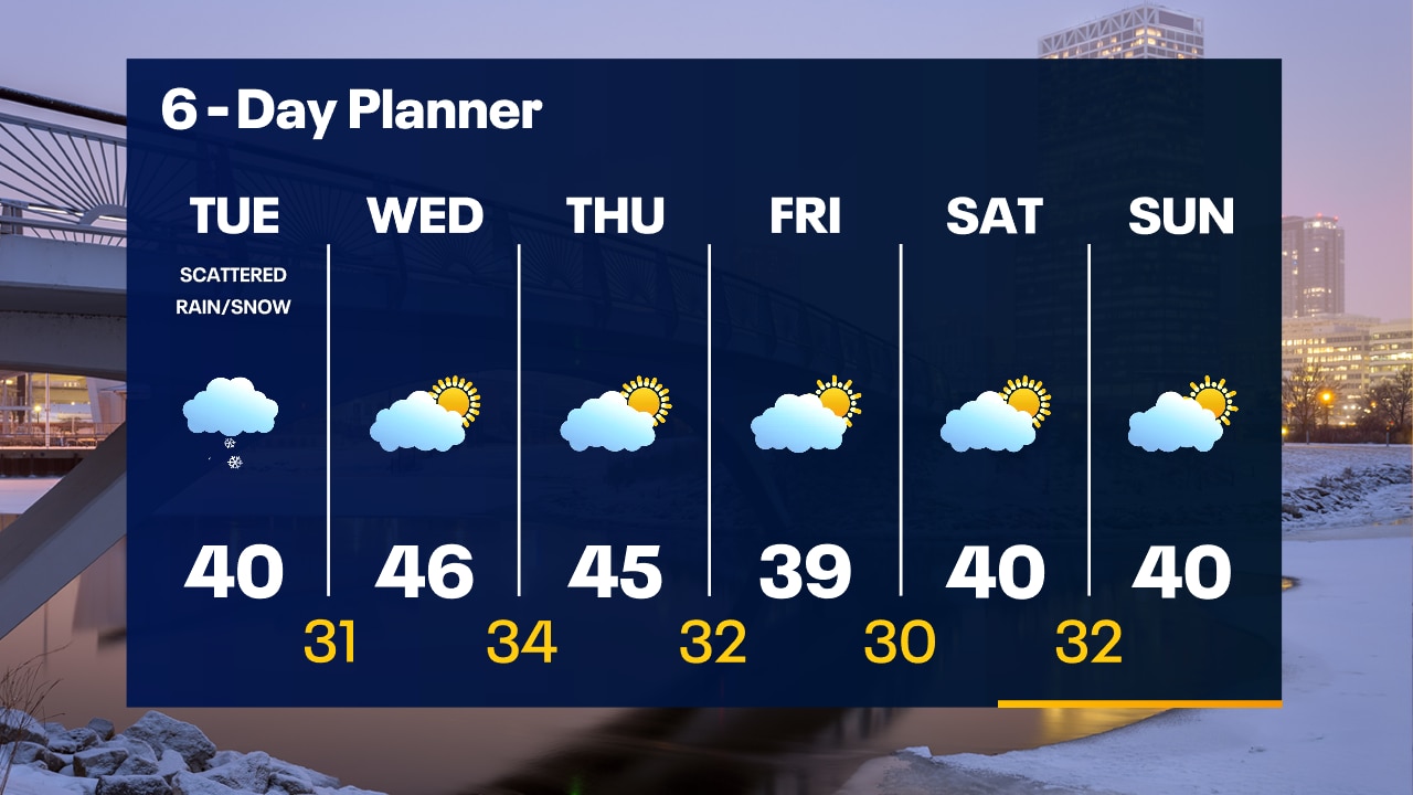
A few light rain/snow showers are possible overnight with temperatures in the 30s. Mostly cloudy on Tuesday with a few light/rain snow showers during the day. High around 40. The sun returns Wednesday.
A few light rain/snow showers are possible overnight with temperatures in the 30s. Mostly cloudy on Tuesday with a few light/rain snow showers during the day. High around 40. The sun returns Wednesday.
Weather Webcast with Tom Wachs
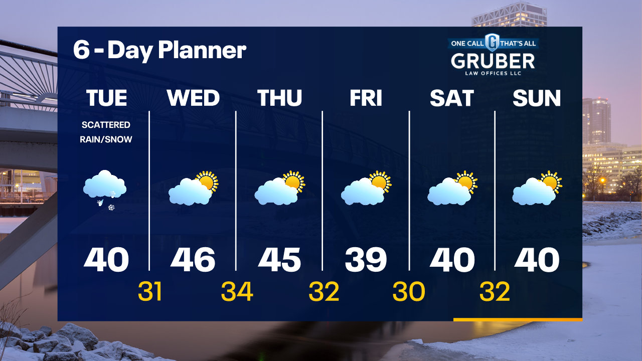
Increasing clouds tonight with light rain/snow overnight and scattered light rain/snow showers Tuesday. Highs around 40 on Tuesday. Warming up on Wednesday with sun returning.
Increasing clouds tonight with light rain/snow overnight and scattered light rain/snow showers Tuesday. Highs around 40 on Tuesday. Warming up on Wednesday with sun returning.

Weather Webcast with Stephanie Barichello
Enjoy some sun today with highs in the 40s. Light rain is possible tonight with some lingering flurries and drizzle Tuesday. More sunshine the rest of the week.
Enjoy some sun today with highs in the 40s. Light rain is possible tonight with some lingering flurries and drizzle Tuesday. More sunshine the rest of the week.
Weather webcast with Lisa Michaels
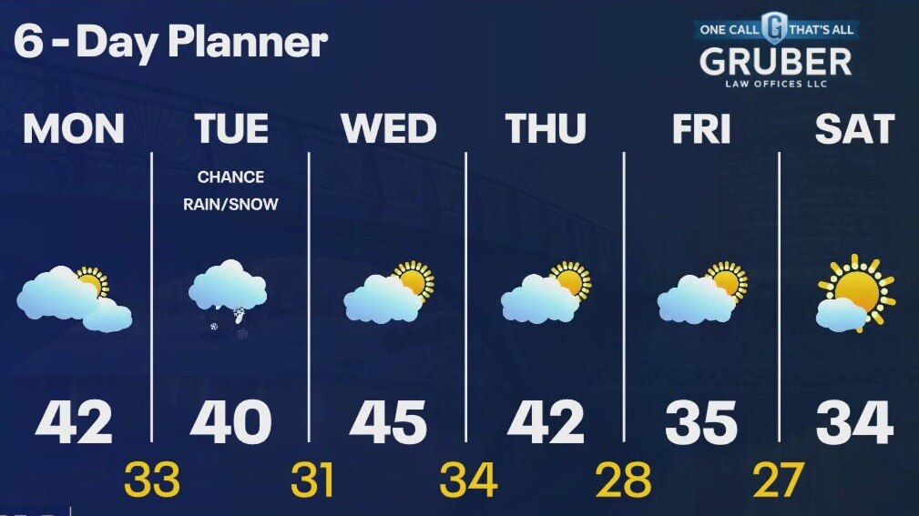
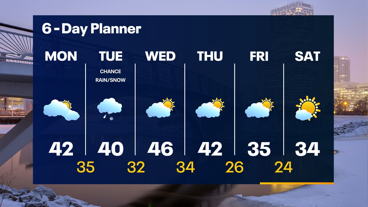
Mostly cloudy Monday with peeks of sun during the afternoon. Highs in the low 40s. A system from Canada moves in Monday night into early Tuesday. This brings a chance for rain/snow showers. Highs around 40. More sunshine is in store for the rest of the week! Highs remain in the lower 40s Wednesday and Thursday. Cooler temps, but still above average, come into play on Friday and Saturday with highs in the 30s.
Mostly cloudy Monday with peeks of sun during the afternoon. Highs in the low 40s. A system from Canada moves in Monday night into early Tuesday. This brings a chance for rain/snow showers. Highs around 40. More sunshine is in store for the rest of the week! Highs remain in the lower 40s Wednesday and Thursday. Cooler temps, but still above average, come into play on Friday and Saturday with highs in the 30s.
Weather Webcast with Tom Wachs
Dense fog developing overnight with temperatures in the upper 20s to low 30s. Morning dense fog on Monday with a few peeks of afternoon sun. Highs in the low 40s.
Dense fog developing overnight with temperatures in the upper 20s to low 30s. Morning dense fog on Monday with a few peeks of afternoon sun. Highs in the low 40s.

Weather Webcast with Tom Wachs
Mostly cloudy tonight with temperatures dropping through the 30s. Some peeks of sun on Monday with highs in the low 40s. Rain/snow showers return Tuesday.
Mostly cloudy tonight with temperatures dropping through the 30s. Some peeks of sun on Monday with highs in the low 40s. Rain/snow showers return Tuesday.
Weather webcast with Lisa Michaels
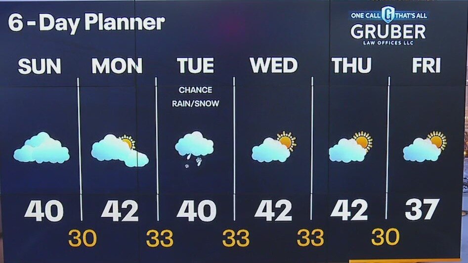
Cloudy with morning fog and drizzle. Cloudy in the afternoon with highs in the upper 30s to 40F. Above average temperatures (+10F) heading into the last few days of January and beginning February. We have a chance to see some sun on Monday, otherwise increasing clouds with a chance for rain/snow mix on Tuesday. Staying mild the rest of the week, but temperatures drop Friday into the middle 30s.
Cloudy with morning fog and drizzle. Cloudy in the afternoon with highs in the upper 30s to 40F. Above average temperatures (+10F) heading into the last few days of January and beginning February. We have a chance to see some sun on Monday, otherwise increasing clouds with a chance for rain/snow mix on Tuesday. Staying mild the rest of the week, but temperatures drop Friday into the middle 30s.
Weather Webcast with Stephanie Barichello
More fog and drizzle tonight, then mostly cloudy on Sunday. Some sunshine possible Monday then a brief chance at wintry mix Tuesday morning. Staying mild all next week.
More fog and drizzle tonight, then mostly cloudy on Sunday. Some sunshine possible Monday then a brief chance at wintry mix Tuesday morning. Staying mild all next week.
Weather webcast with Lisa Michaels
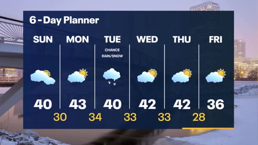
Dense fog advisory until 10am Saturday. Otherwise, cloudy with periods of fog and mist. Highs in the upper 30s. Clouds stay in the forecast with areas of fog on Sunday. Highs in the upper 30s. Next chance of seeing some sunshine is on Monday with better chances near the end of next week. Rain/Snow possible with a quick system on Tuesday
Dense fog advisory until 10am Saturday. Otherwise, cloudy with periods of fog and mist. Highs in the upper 30s. Clouds stay in the forecast with areas of fog on Sunday. Highs in the upper 30s. Next chance of seeing some sunshine is on Monday with better chances near the end of next week. Rain/Snow possible with a quick system on Tuesday

Weather Webcast with Meteorologist Eric Manges
Rain comes to an end but more fog heading into the weekend
Rain comes to an end but more fog heading into the weekend
Weather webcast with Lisa Michaels
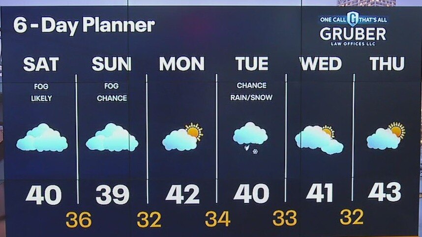
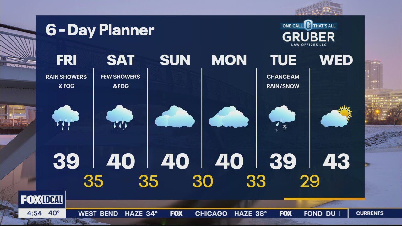
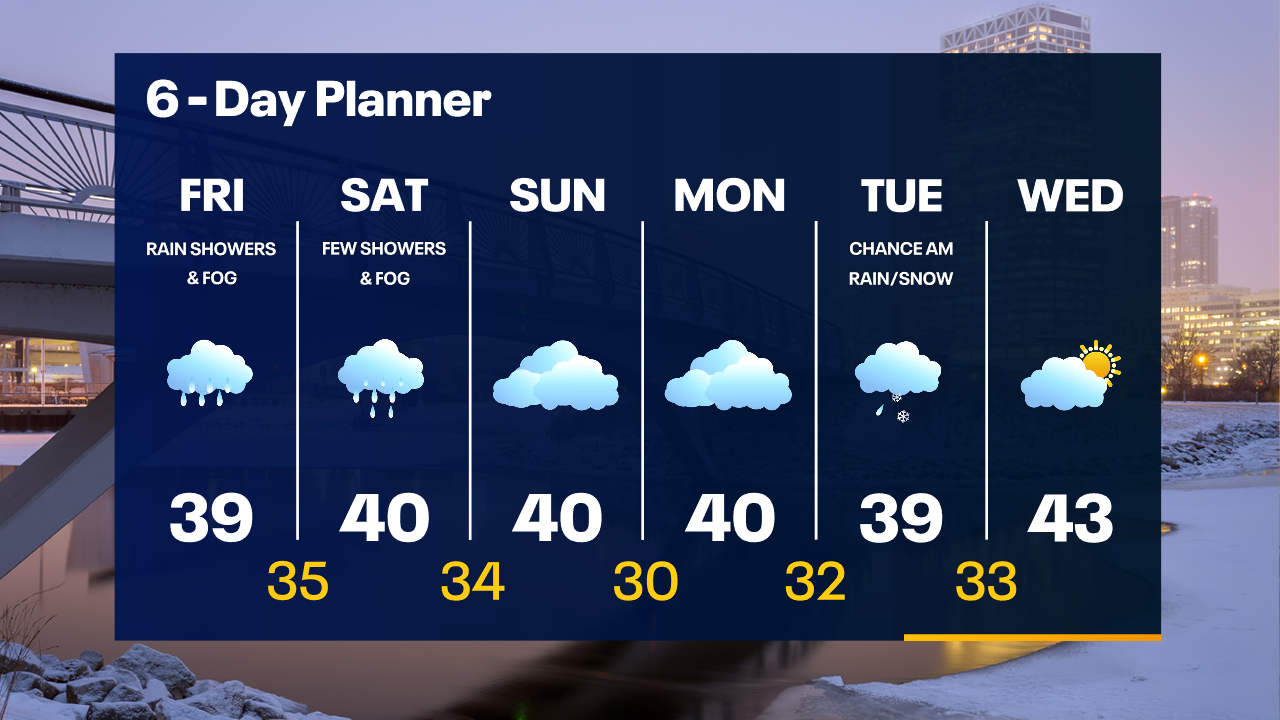
On and off rain showers Friday with highs in the upper 30s. Fog continues today. More fog expected Friday night into Saturday. Low temps in the low to mid 30s. A few rain showers are possible Saturday with more fog and highs around 40. Cloudy skies continue into early next week. A few rain/snow showers are possible Tuesday morning. Some sun is possible mid-week next week.
On and off rain showers Friday with highs in the upper 30s. Fog continues today. More fog expected Friday night into Saturday. Low temps in the low to mid 30s. A few rain showers are possible Saturday with more fog and highs around 40. Cloudy skies continue into early next week. A few rain/snow showers are possible Tuesday morning. Some sun is possible mid-week next week.
Weather Webcast with Tom Wachs
Rainy and foggy overnight with temperatures in the 30s. Off-and-on rain Friday with more fog. Highs in the upper 30s. Staying foggy on Saturday with a few spotty rain showers.
Rainy and foggy overnight with temperatures in the 30s. Off-and-on rain Friday with more fog. Highs in the upper 30s. Staying foggy on Saturday with a few spotty rain showers.

Weather Webcast with Stephanie Barichello
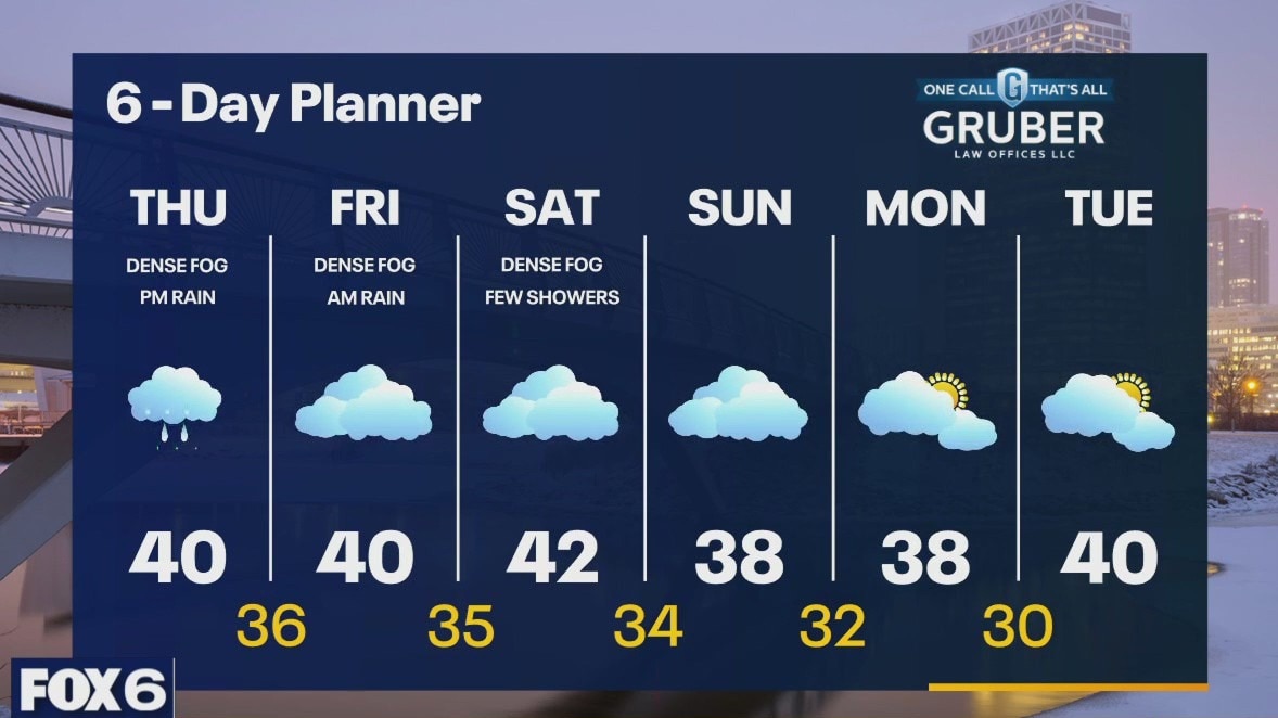
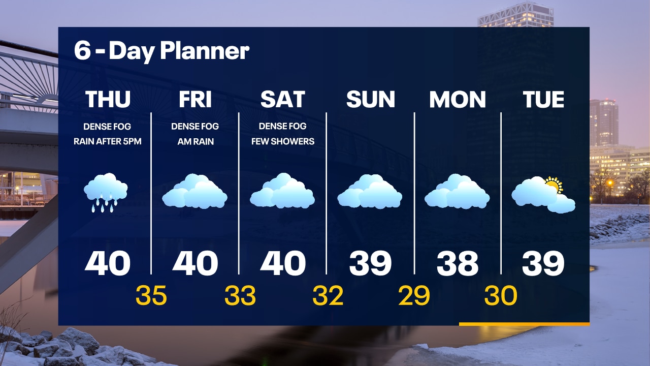
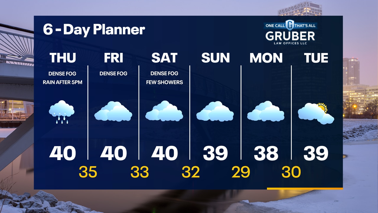
Dense fog will continue this afternoon then steady rain moves in this evening. Rain may be heavy at times tonight, then light lingering rain throughout Friday. Should begin to dry out Saturday but patchy fog will still be possible throughout the weekend.
Dense fog will continue this afternoon then steady rain moves in this evening. Rain may be heavy at times tonight, then light lingering rain throughout Friday. Should begin to dry out Saturday but patchy fog will still be possible throughout the weekend.
Weather webcast with Rob Haswell
Dense Fog Advisory for all of our area is in place until 9am this morning. The parade of low pressure systems continues today with another surge of moisture arriving this afternoon with .25 to .50" worth of rain likely through noon on Friday. Temperatures will remain steady in the upper 30s and low 40s today and into the weekend. Overnight lows will remain very warm and many areas won't fall below freezing for a few days.
Dense Fog Advisory for all of our area is in place until 9am this morning. The parade of low pressure systems continues today with another surge of moisture arriving this afternoon with .25 to .50" worth of rain likely through noon on Friday. Temperatures will remain steady in the upper 30s and low 40s today and into the weekend. Overnight lows will remain very warm and many areas won't fall below freezing for a few days.
Weather Webcast with Tom Wachs
Dense fog overnight with a Dense Fog Advisory until 9am. Foggy all day Thursday with highs around 40. Rain moves in after 6-7pm.
Dense fog overnight with a Dense Fog Advisory until 9am. Foggy all day Thursday with highs around 40. Rain moves in after 6-7pm.
Weather Webcast with Tom Wachs
Dense Fog Advisory again tonight. Foggy with temperatures in the 30s. Foggy on Thursday with a high around 40. Rain moves in after 5-6pm Thursday.
Dense Fog Advisory again tonight. Foggy with temperatures in the 30s. Foggy on Thursday with a high around 40. Rain moves in after 5-6pm Thursday.
Weather Webcast with Stephanie Barichello
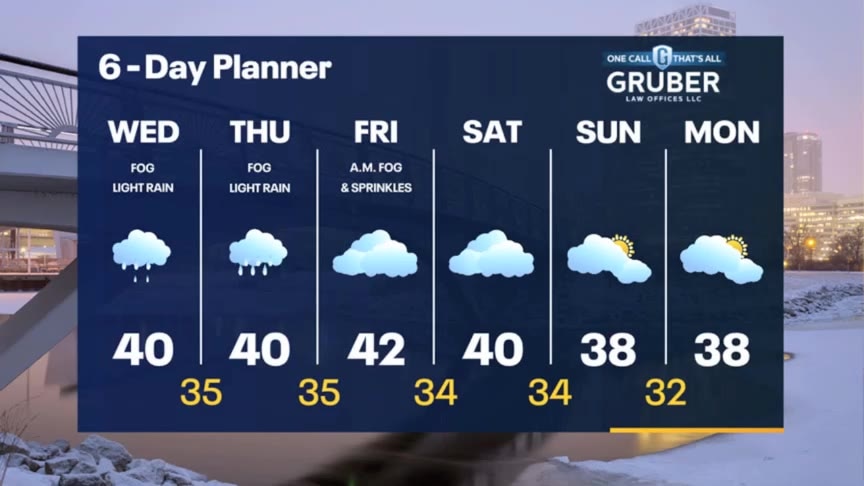
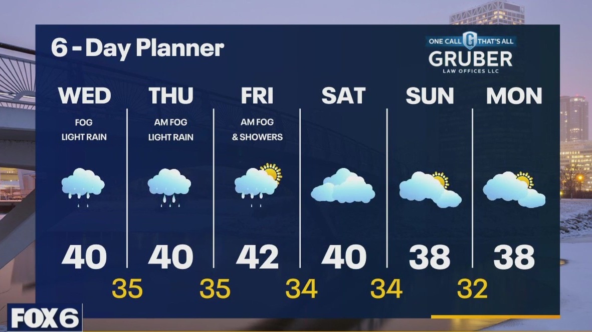
Dense fog and light rain expected today, then more dense fog tonight. Temperatures will remain above freezing so icy spots are not expected. Fog will linger Thursday then a steadier rain Thursday afternoon and evening. Drying out later Friday and into the weekend. Minor flooding expected due to melting and rain showers in the days ahead.
Dense fog and light rain expected today, then more dense fog tonight. Temperatures will remain above freezing so icy spots are not expected. Fog will linger Thursday then a steadier rain Thursday afternoon and evening. Drying out later Friday and into the weekend. Minor flooding expected due to melting and rain showers in the days ahead.
Weather webcast with Rob Haswell
Warm, moist air continues to push into our area today and that combined with melting snow is creating a dense fog in many areas. A Dense Fog Advisory is in effect until 10am. A area of light rain moves over us later this morning and through the afternoon. A few showers are possible even overnight into Thursday morning. Highs today will warm to near 40 and we stay well into the 30s overnight and return to near 40 Thursday. A steady light rain returns by Thursday afternoon and light showers are possible into Friday morning. We should dry up for a few days after that.
Warm, moist air continues to push into our area today and that combined with melting snow is creating a dense fog in many areas. A Dense Fog Advisory is in effect until 10am. A area of light rain moves over us later this morning and through the afternoon. A few showers are possible even overnight into Thursday morning. Highs today will warm to near 40 and we stay well into the 30s overnight and return to near 40 Thursday. A steady light rain returns by Thursday afternoon and light showers are possible into Friday morning. We should dry up for a few days after that.