


Weather Webcast with Tom Wachs
Areas of dense fog overnight into Tuesday morning with temperatures in the upper 20s to low 30s. Some sun after the fog burns off Tuesday with highs in the 40s. 50 returns on Wednesday.
Areas of dense fog overnight into Tuesday morning with temperatures in the upper 20s to low 30s. Some sun after the fog burns off Tuesday with highs in the 40s. 50 returns on Wednesday.

Weather Webcast with Tom Wachs
Fog developing again tonight with temperatures in the 30s. The fog will gradually burn off on Tuesday with highs in the 40s. 50s on Wednesday.
Fog developing again tonight with temperatures in the 30s. The fog will gradually burn off on Tuesday with highs in the 40s. 50s on Wednesday.

Weather webcast with Lisa Michaels
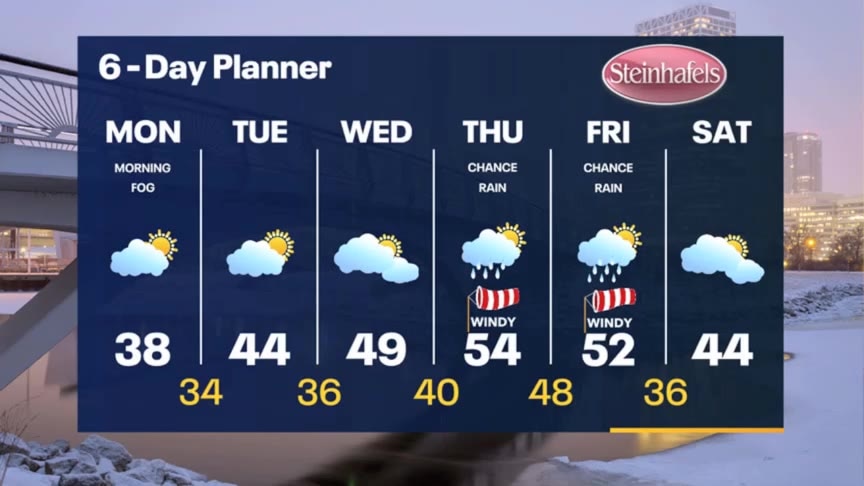
Reduced visibility with slick spots on untreated surfaces is possible. Frost on vehicles too. Partly cloudy to mostly cloudy on Monday with highs in the upper 30s. Steadily warming into the mid/upper 40s early this week and the 50s by the end of the week. Rain is likely on Thursday and early Friday, but moving out by the weekend.
Reduced visibility with slick spots on untreated surfaces is possible. Frost on vehicles too. Partly cloudy to mostly cloudy on Monday with highs in the upper 30s. Steadily warming into the mid/upper 40s early this week and the 50s by the end of the week. Rain is likely on Thursday and early Friday, but moving out by the weekend.
Weather Webcast with Stephanie Barichello
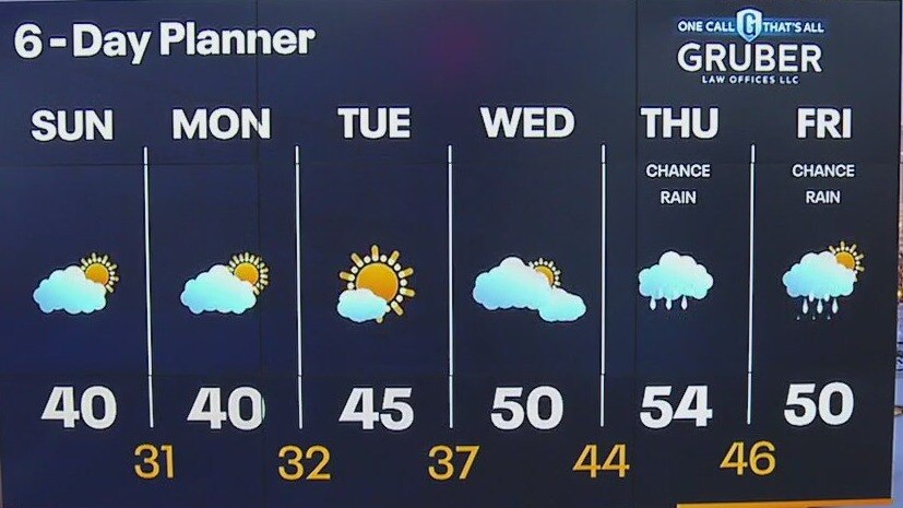
Dense, freezing fog could create hazardous travel Monday morning, then expect improving conditions midday. Similar Tuesday, then warming up mid to late week. We'll be approaching record highs but will also have rain around.
Dense, freezing fog could create hazardous travel Monday morning, then expect improving conditions midday. Similar Tuesday, then warming up mid to late week. We'll be approaching record highs but will also have rain around.

Weather Webcast with Stephanie Barichello
Fog is possible again tonight, possibly freezing in spots as temperatures fall into the 20s and low 30s. Some sun by Monday afternoon, then similar conditions on Tuesday. Warming later in the week with rain showers possible.
Fog is possible again tonight, possibly freezing in spots as temperatures fall into the 20s and low 30s. Some sun by Monday afternoon, then similar conditions on Tuesday. Warming later in the week with rain showers possible.
Weather webcast with Lisa Michaels
A dense fog advisory until 10am for some counties. Fog will impact visibility, and freezing fog is possible in areas below 32F. Another mostly cloudy to partly cloudy day with highs in the upper 30s to low 40s. Calm and mild weather continue through Wednesday this week due to an Omega blocking pattern in the atmosphere.
A dense fog advisory until 10am for some counties. Fog will impact visibility, and freezing fog is possible in areas below 32F. Another mostly cloudy to partly cloudy day with highs in the upper 30s to low 40s. Calm and mild weather continue through Wednesday this week due to an Omega blocking pattern in the atmosphere.

Weather Webcast with Meteorologist Eric Manges
Mild conditions hold then an even bigger warm-up on Wednesday
Mild conditions hold then an even bigger warm-up on Wednesday
Weather webcast with Lisa Michaels
Isolated fog in the morning. Otherwise, partly cloudy and temps in the lower 30s. Partly cloudy on Saturday with highs in the upper 30s to low 40s. On and off cloud cover is possible on Sunday which could keep up warmer or a few degrees cooler. Still above average for February with 50s possible next week.
Isolated fog in the morning. Otherwise, partly cloudy and temps in the lower 30s. Partly cloudy on Saturday with highs in the upper 30s to low 40s. On and off cloud cover is possible on Sunday which could keep up warmer or a few degrees cooler. Still above average for February with 50s possible next week.

Weather Webcast with Meteorologist Eric Manges
Staying mild and calm into next week
Staying mild and calm into next week
Weather Webcast with Stephanie Barichello
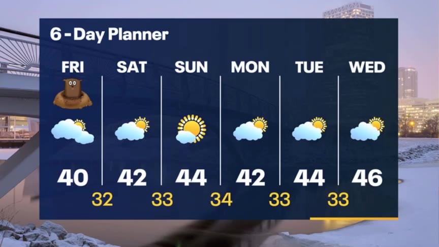
Mostly cloudy this afternoon with temperatures in the 30s to around 40. More sun expected over the weekend, with possible morning fog. Temperatures remain in the 40s much of next week.
Mostly cloudy this afternoon with temperatures in the 30s to around 40. More sun expected over the weekend, with possible morning fog. Temperatures remain in the 40s much of next week.
Weather webcast with Rob Haswell
A few flurries overnight and early this morning along with some patchy drizzle or freezing drizzle. Some area roads may be a bit slick. After a cloudy start we should get some afternoon sun. Highs will reach the upper 30s to near 40. Still expecting sun this weekend with highs in the low to mid 40s. We stay warm well into next week. No major precipitation events are likely into the middle of next week.
A few flurries overnight and early this morning along with some patchy drizzle or freezing drizzle. Some area roads may be a bit slick. After a cloudy start we should get some afternoon sun. Highs will reach the upper 30s to near 40. Still expecting sun this weekend with highs in the low to mid 40s. We stay warm well into next week. No major precipitation events are likely into the middle of next week.

Weather Webcast with Tom Wachs
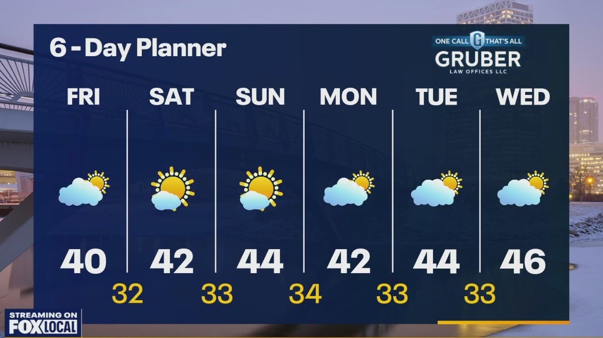
Breezy overnight with temperatures in the 30s. Partly sunny on Friday with highs around 40. Lots of sun this weekend with highs in the 40s.
Breezy overnight with temperatures in the 30s. Partly sunny on Friday with highs around 40. Lots of sun this weekend with highs in the 40s.

Weather Webcast with Tom Wachs
A few passing clouds tonight with temperatures in the 30s. Partly sunny and mild on Friday with highs around 40. Lots of sun this weekend with highs in the low-to-mid 40s.
A few passing clouds tonight with temperatures in the 30s. Partly sunny and mild on Friday with highs around 40. Lots of sun this weekend with highs in the low-to-mid 40s.

Weather Webcast with Meteorologist Eric Manges
Calm and mild is the theme for the start of February
Calm and mild is the theme for the start of February
Weather webcast with Rob Haswell
A clear start to our day but more clouds will return this afternoon and evening. Highs will again reach the low 40s today. We remain above freezing in many spots overnight. Sun returns Friday and for the weekend with highs again in the low 40s and lows well into the 30s. We look to stay mostly dry through mid to late parts of next week.
A clear start to our day but more clouds will return this afternoon and evening. Highs will again reach the low 40s today. We remain above freezing in many spots overnight. Sun returns Friday and for the weekend with highs again in the low 40s and lows well into the 30s. We look to stay mostly dry through mid to late parts of next week.

Weather Webcast with Tom Wachs
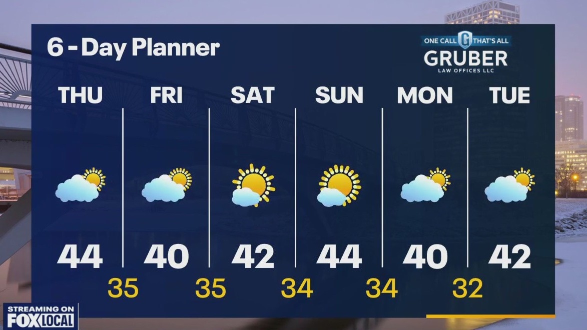
Patchy fog overnight and into the morning with temperatures in the 30s. Increasing clouds on Thursday with highs in the low-to-mid 40s.
Patchy fog overnight and into the morning with temperatures in the 30s. Increasing clouds on Thursday with highs in the low-to-mid 40s.
Weather Webcast with Tom Wachs
Mostly clear tonight with patchy fog developing. Temperatures in the 30s. Morning patchy fog on Thursday, otherwise mostly cloudy. Highs in the low-to-mid 40s.
Mostly clear tonight with patchy fog developing. Temperatures in the 30s. Morning patchy fog on Thursday, otherwise mostly cloudy. Highs in the low-to-mid 40s.

Weather webcast with Rob Haswell
High pressure begins to build across our area today with a SW wind developing and some sunshine returning. Temperatures will warm into the low to mid 40s today and overnight lows will stay very mild in the low to mid 30s. These are well above average temperatures. We stay dry and relatively calm for the next several days. Quiet through the weekend with highs around 40.
High pressure begins to build across our area today with a SW wind developing and some sunshine returning. Temperatures will warm into the low to mid 40s today and overnight lows will stay very mild in the low to mid 30s. These are well above average temperatures. We stay dry and relatively calm for the next several days. Quiet through the weekend with highs around 40.

Weather Webcast with Tom Wachs
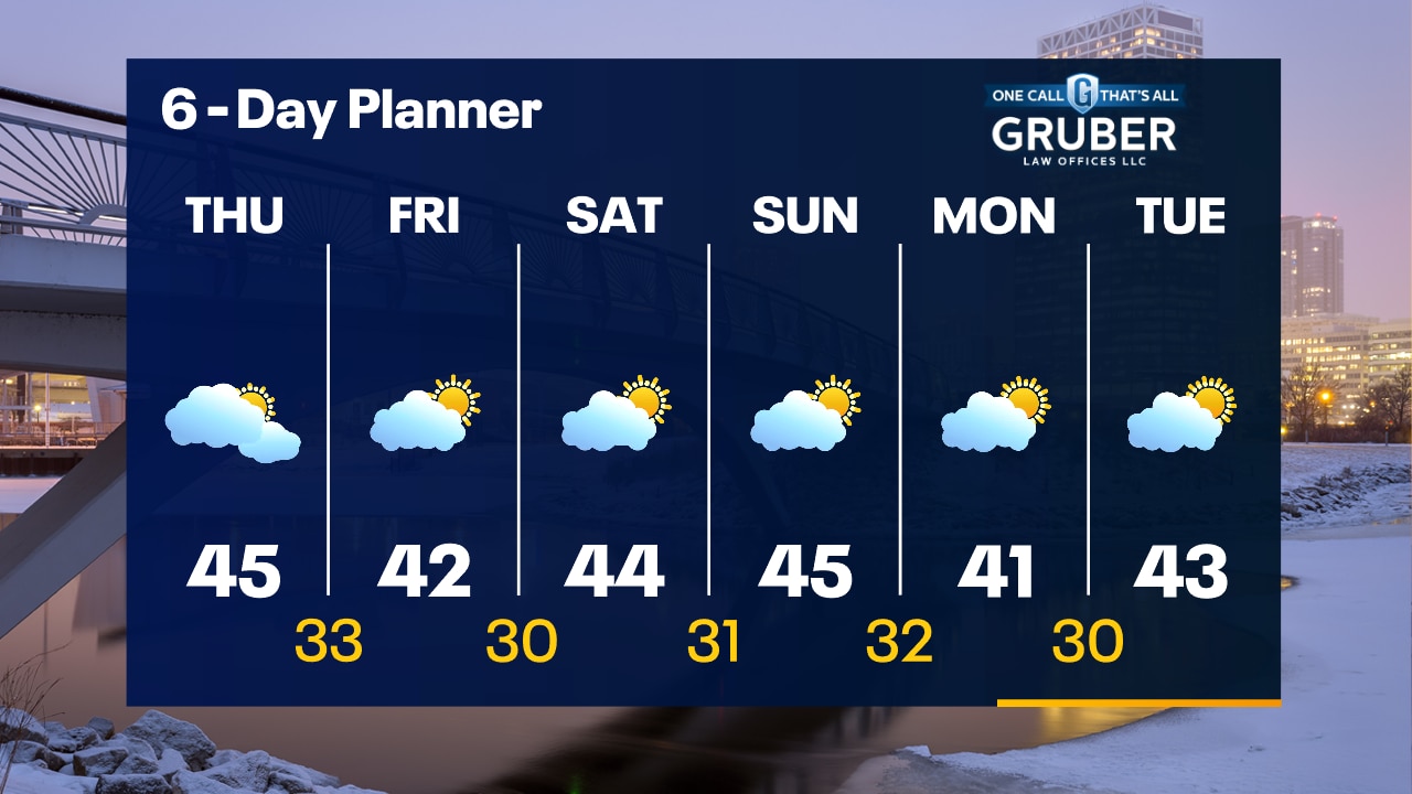
Gradual clearing on Wednesday morning with sun returning by afternoon. Breezy with highs in the 40s. Well above-average temperatures continue into next week.
Gradual clearing on Wednesday morning with sun returning by afternoon. Breezy with highs in the 40s. Well above-average temperatures continue into next week.

Weather Webcast with Tom Wachs
Cloudy skies tonight with temperatures in the 30s. Gradual clearing on Wednesday with sun making a return by afternoon. Breezy with highs in the mid-40s.
Cloudy skies tonight with temperatures in the 30s. Gradual clearing on Wednesday with sun making a return by afternoon. Breezy with highs in the mid-40s.