


Weather webcast with Rob Haswell
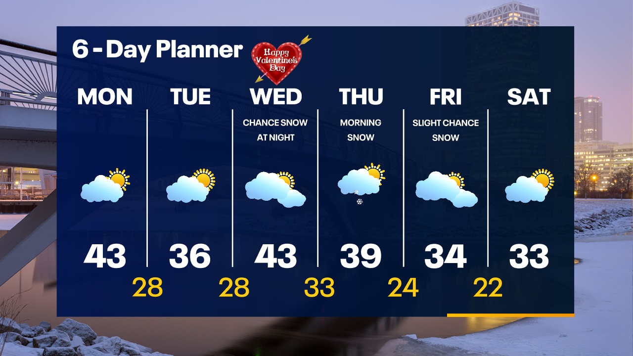
A chilly start to our day with the coolest temperatures since late last month. Ample sun today will warm us back into the low 40s this afternoon before cooling back to the 20s tonight. A low arrives with a chance for rain and snow by later Wednesday into early Thursday. We cool to slightly below average highs by Friday and into the weekend.
A chilly start to our day with the coolest temperatures since late last month. Ample sun today will warm us back into the low 40s this afternoon before cooling back to the 20s tonight. A low arrives with a chance for rain and snow by later Wednesday into early Thursday. We cool to slightly below average highs by Friday and into the weekend.
Weather Webcast with Tom Wachs
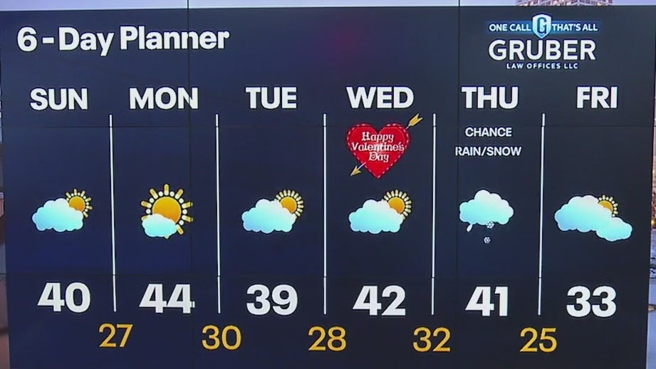
Clear and chilly overnight with temperatures in the 30s. Partly to mostly sunny on Monday with highs in the low-to-mid 40s. Cooler on Tuesday before 40s return on Wednesday.
Clear and chilly overnight with temperatures in the 30s. Partly to mostly sunny on Monday with highs in the low-to-mid 40s. Cooler on Tuesday before 40s return on Wednesday.

Weather Webcast with Tom Wachs
Mostly clear tonight with temperatures falling into the 20s. Partly to mostly sunny on Monday with highs in the low-to-mid 40s. Cooling slightly on Tuesday.
Mostly clear tonight with temperatures falling into the 20s. Partly to mostly sunny on Monday with highs in the low-to-mid 40s. Cooling slightly on Tuesday.
Weather webcast with Lisa Michaels
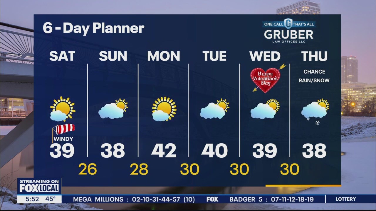
A cooler start with frost and temps in the 20s Sunday morning. Gradually decreasing clouds later today. Otherwise, highs in the upper 30s to 40 degrees. Next chance of rain/snow possible Wednesday night into Thursday and possibly Friday. Spotty chances. Seasonable temps returns by Friday and next weekend.
A cooler start with frost and temps in the 20s Sunday morning. Gradually decreasing clouds later today. Otherwise, highs in the upper 30s to 40 degrees. Next chance of rain/snow possible Wednesday night into Thursday and possibly Friday. Spotty chances. Seasonable temps returns by Friday and next weekend.

Weather Webcast with Meteorologist Eric Manges
Warmer than average moving forward but not by much
Warmer than average moving forward but not by much
Weather Webcast with Meteorologist Eric Manges
Getting closer to normal heading into mid-February
Getting closer to normal heading into mid-February
Weather webcast with Eric Manges
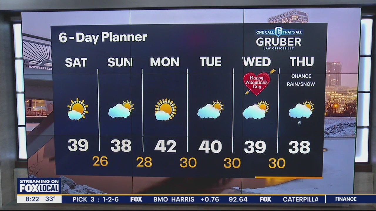
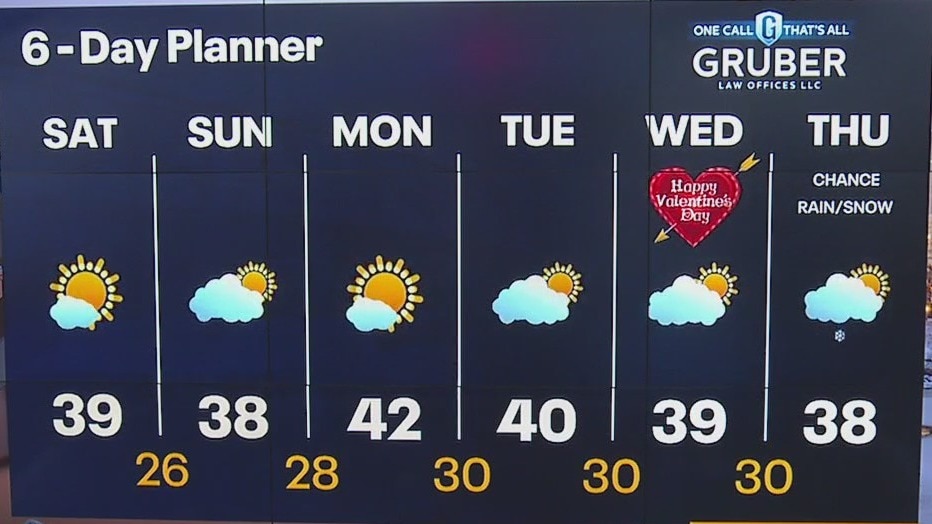
Calmer into the weekend with morning clouds clearing into afternoon sun on Saturday. Highs work their way into the upper 30s both today and tomorrow. Slightly warmer Monday and Tuesday but dry. Our next chance of rain/snow arrives Wednesday night into Thursday.
Calmer into the weekend with morning clouds clearing into afternoon sun on Saturday. Highs work their way into the upper 30s both today and tomorrow. Slightly warmer Monday and Tuesday but dry. Our next chance of rain/snow arrives Wednesday night into Thursday.
Weather Webcast with Meteorologist Eric Manges
Calmer conditions return after historic warmth and storms
Calmer conditions return after historic warmth and storms
Weather webcast with Rob Haswell
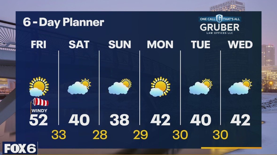
Calmer conditions today but still windy with a strong SW wind becoming NW late in the day. Highs will reach the upper 40s to low 50s before cooling fairly quickly after the wind shift this evening. We can expect dry conditions with ample sunshine today and into Saturday. Saturday's highs will be in the upper 30s to near 40. We stay dry with lows in the upper 30s and low 40s through the middle of next week
Calmer conditions today but still windy with a strong SW wind becoming NW late in the day. Highs will reach the upper 40s to low 50s before cooling fairly quickly after the wind shift this evening. We can expect dry conditions with ample sunshine today and into Saturday. Saturday's highs will be in the upper 30s to near 40. We stay dry with lows in the upper 30s and low 40s through the middle of next week
Weather Webcast with Tom Wachs
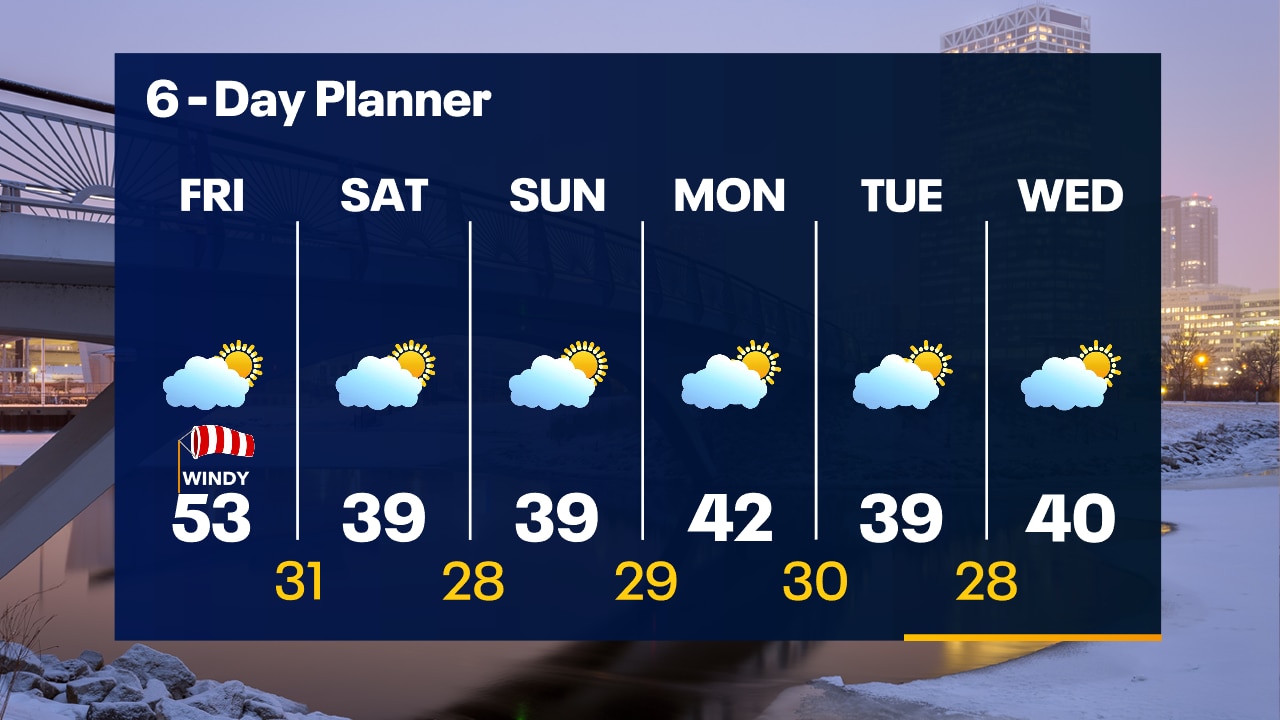
Drying out overnight with temperatures falling into the 40s. Partly sunny, windy and still warm on Friday with a record high in the low 50s.
Drying out overnight with temperatures falling into the 40s. Partly sunny, windy and still warm on Friday with a record high in the low 50s.
Weather Webcast with Stephanie Barichello
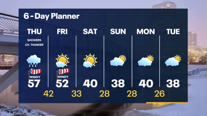
Warm and windy this afternoon with a chance for showers and storms. A few storms may be strong or even severe. Drying out after 10pm, then some sun returns Friday. Cooler but quiet over the weekend.
Warm and windy this afternoon with a chance for showers and storms. A few storms may be strong or even severe. Drying out after 10pm, then some sun returns Friday. Cooler but quiet over the weekend.
Weather webcast with Rob Haswell
A low that is strengthening over the Dakotas today will bring rain and warm air our way. Showers are likely late morning and early afternoon then again later this afternoon and evening with a chance for thunderstorms later in the day. Highs will reach the low to mid 50s today and stay in the 50s tomorrow - both days will be near record warmth. We cool down this weekend but remain above average with some sun and dry conditions returning.
A low that is strengthening over the Dakotas today will bring rain and warm air our way. Showers are likely late morning and early afternoon then again later this afternoon and evening with a chance for thunderstorms later in the day. Highs will reach the low to mid 50s today and stay in the 50s tomorrow - both days will be near record warmth. We cool down this weekend but remain above average with some sun and dry conditions returning.
Weather Webcast with Tom Wachs
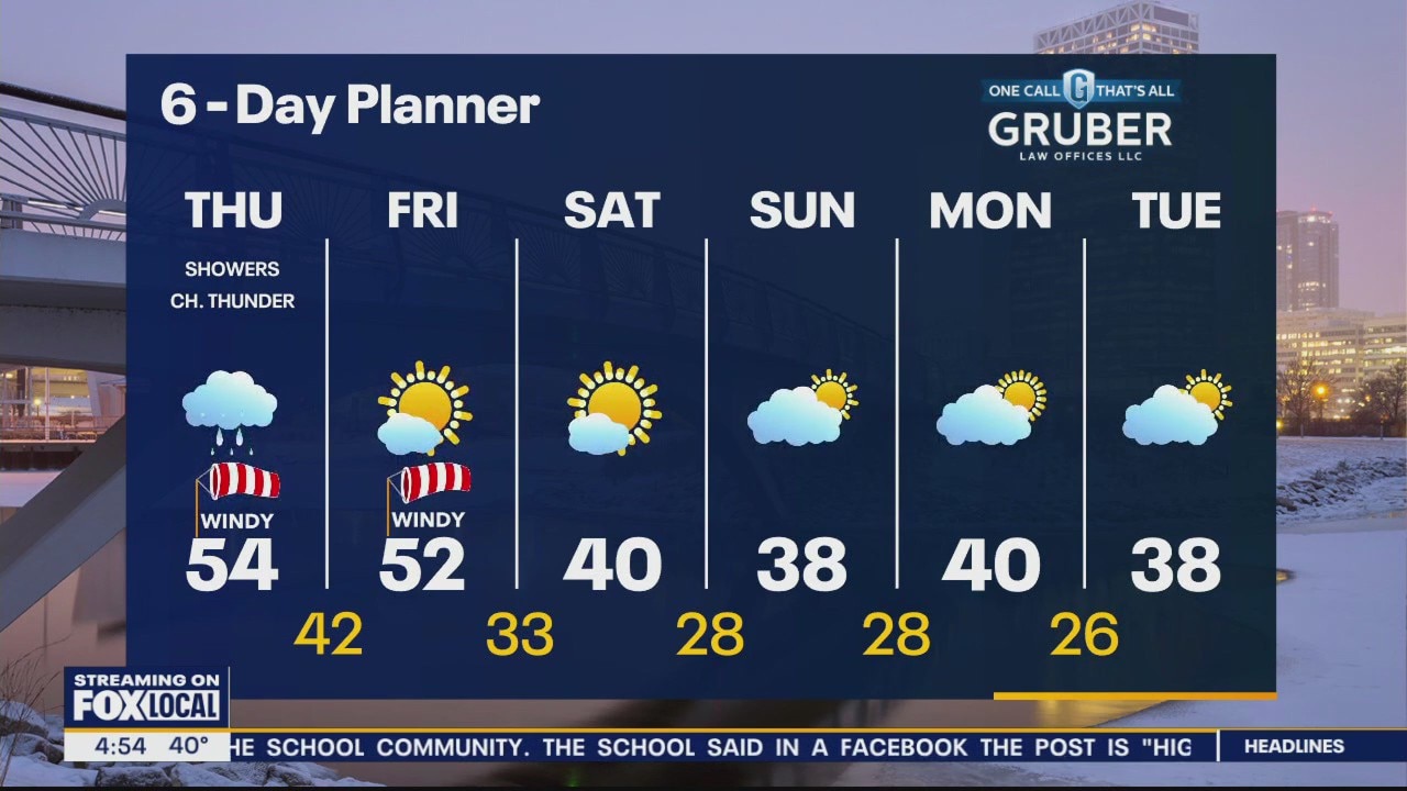
Cloudy overnight with temperatures in the 30s. Cloudy on Thursday morning with midday rain. Windy and warm during the afternoon with highs in the low 50s. A few scattered t-storms are possible Thursday evening.
Cloudy overnight with temperatures in the 30s. Cloudy on Thursday morning with midday rain. Windy and warm during the afternoon with highs in the low 50s. A few scattered t-storms are possible Thursday evening.
Weather Webcast with Tom Wachs
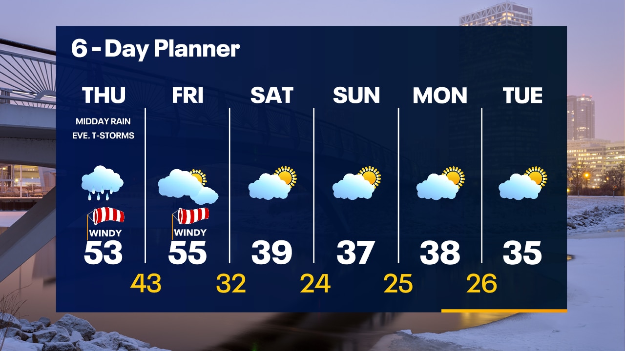
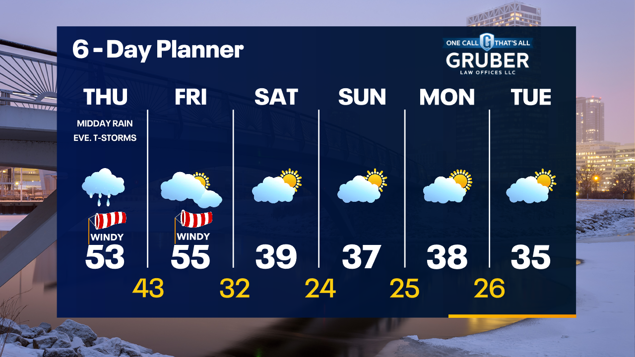
Cloudy skies tonight with temperatures in the 30s to around 40. Midday rain on Thursday with gusty southwest winds and highs in the low 50s. A few evening t-storms are possible.
Cloudy skies tonight with temperatures in the 30s to around 40. Midday rain on Thursday with gusty southwest winds and highs in the low 50s. A few evening t-storms are possible.

Weather webcast with Rob Haswell
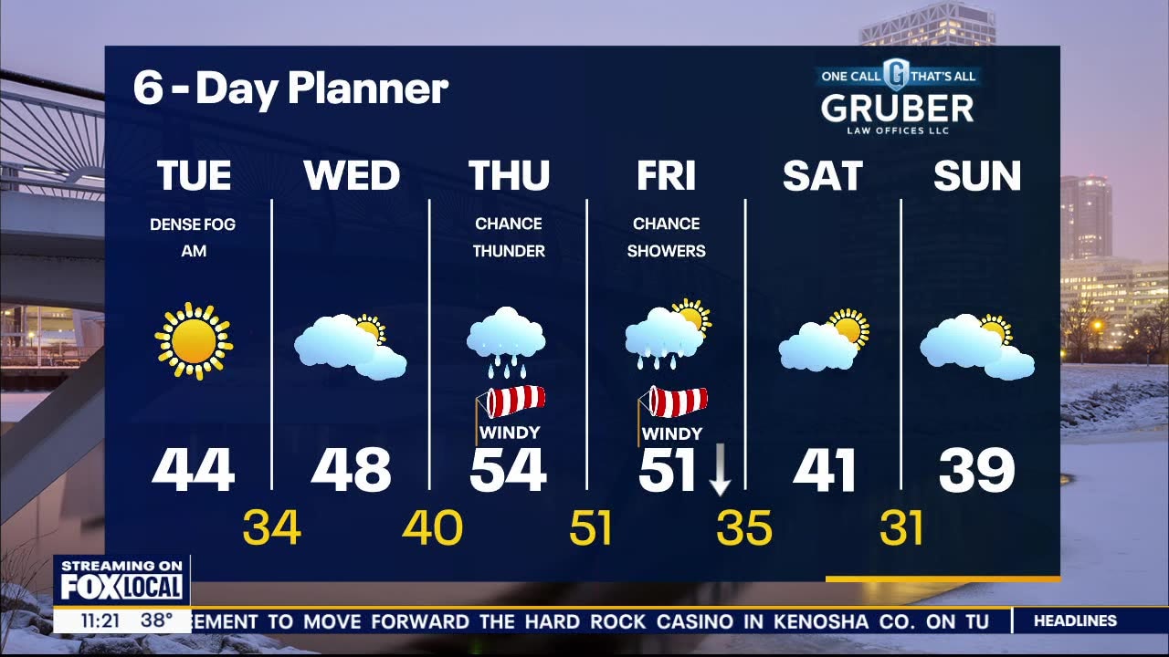
Dense Fog Advisory for all of Southeastern Wisconsin until 10am. Freezing fog is also an issue in some areas. We stay mostly cloudy with a mild high in the upper 40s today. We get warmer tomorrow ahead of a low pressure system. Highs will reach the low to mid 50s. Rain is likely by Thursday afternoon with a chance for thunderstorms. We clear out on Friday. Cooler air arrives for the weekend but we remain above average.
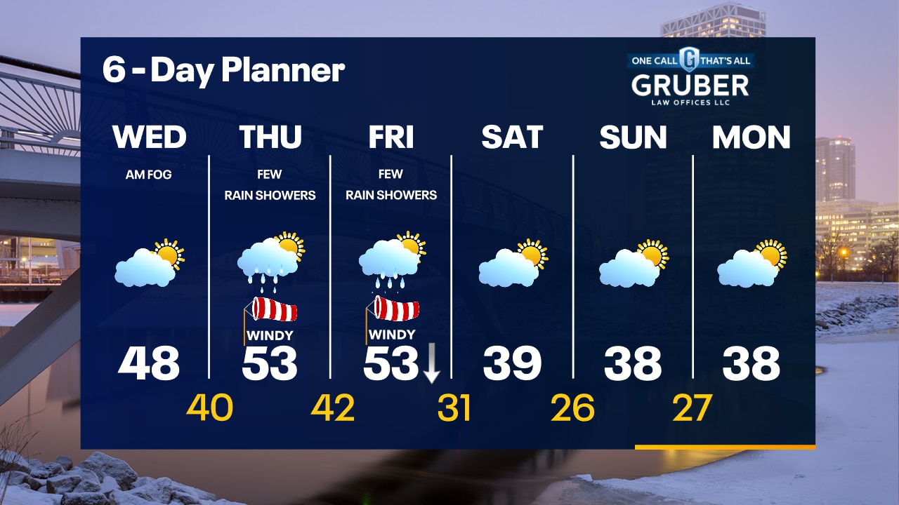
Dense Fog Advisory for all of Southeastern Wisconsin until 10am. Freezing fog is also an issue in some areas. We stay mostly cloudy with a mild high in the upper 40s today. We get warmer tomorrow ahead of a low pressure system. Highs will reach the low to mid 50s. Rain is likely by Thursday afternoon with a chance for thunderstorms. We clear out on Friday. Cooler air arrives for the weekend but we remain above average.
Weather Webcast with Tom Wachs
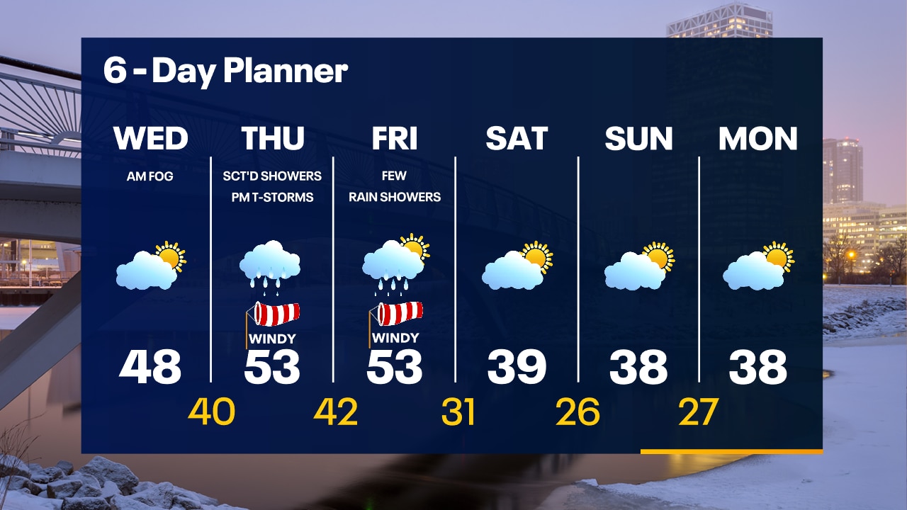
Dense fog overnight with temperatures in the 30s. Fog will burn off by midday. Partly sunny & breezy Wednesday afternoon with highs in the upper 40s. 50s return on Thursday with a chance for showers and t-storms.
Dense fog overnight with temperatures in the 30s. Fog will burn off by midday. Partly sunny & breezy Wednesday afternoon with highs in the upper 40s. 50s return on Thursday with a chance for showers and t-storms.
Weather Webcast with Tom Wachs
Dense Fog Advisory for lakeshore areas until 6am Wednesday. After the fog burns off Wednesday, it will become breezy with highs in the 40s. Record high possible late this week.
Dense Fog Advisory for lakeshore areas until 6am Wednesday. After the fog burns off Wednesday, it will become breezy with highs in the 40s. Record high possible late this week.
Weather webcast with Lisa Michaels
Dense fog in many areas this morning with a Dense Fog Advisory until noon Monday. Mostly cloudy skies transitioning to partly cloudy today.Mild with highs in the low to mid 40s. A low arrives on Thursday with a chance for rain that will linger into Friday accompanied by warm temps in the 50s. We cool down a bit by the weekend but remain well above average.
Dense fog in many areas this morning with a Dense Fog Advisory until noon Monday. Mostly cloudy skies transitioning to partly cloudy today.Mild with highs in the low to mid 40s. A low arrives on Thursday with a chance for rain that will linger into Friday accompanied by warm temps in the 50s. We cool down a bit by the weekend but remain well above average.

Weather webcast with Rob Haswell
Dense fog in many areas this morning with a Dense Fog Advisory until 10 a.m. for Waukesha, Walworth, Jefferson, Dodge, Washington, Sheboygan and Fond du Lac Counties. Mostly cloudy and mild today with highs in the low to mid 40s. We warm even further tomorrow with highs in the upper 40s. A low arrives on Thursday with a chance for rain. That rain lingers into Friday. The low also brings even warmer air with highs in the low 50s. We cool down a bit by the weekend but remain well above average.
Dense fog in many areas this morning with a Dense Fog Advisory until 10 a.m. for Waukesha, Walworth, Jefferson, Dodge, Washington, Sheboygan and Fond du Lac Counties. Mostly cloudy and mild today with highs in the low to mid 40s. We warm even further tomorrow with highs in the upper 40s. A low arrives on Thursday with a chance for rain. That rain lingers into Friday. The low also brings even warmer air with highs in the low 50s. We cool down a bit by the weekend but remain well above average.

Weather Webcast with Tom Wachs
Areas of dense fog overnight into Tuesday morning with temperatures in the upper 20s to low 30s. Some sun after the fog burns off Tuesday with highs in the 40s. 50 returns on Wednesday.
Areas of dense fog overnight into Tuesday morning with temperatures in the upper 20s to low 30s. Some sun after the fog burns off Tuesday with highs in the 40s. 50 returns on Wednesday.