


Weather Webcast with Meteorologist Eric Manges
Warm into Monday but then storms Monday night
Warm into Monday but then storms Monday night
Weather webcast with Lisa Michaels
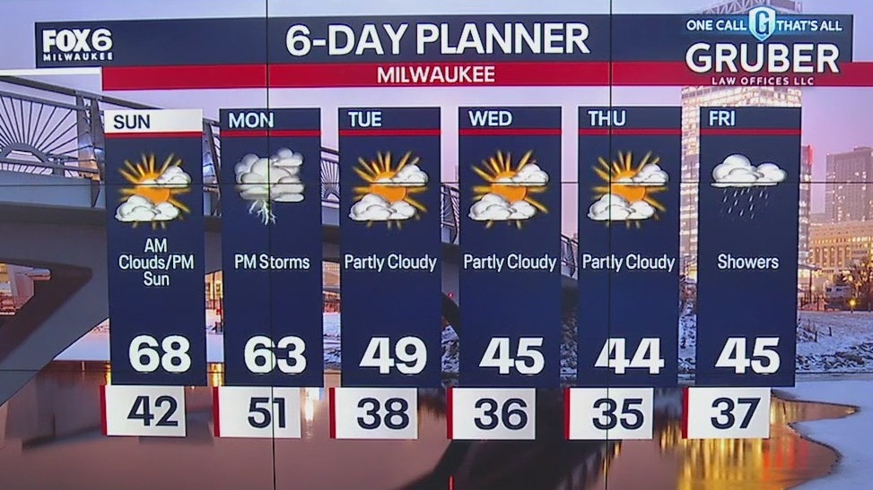
Isolated morning fog otherwise, mild as southeast winds bring in warm air pushing temps into the mid to upper 60s. Mostly sunny to party cloudy Sunday. Rain/storms return Monday afternoon into early Tuesday morning. Watching for the potential of an isolated strong storm. Another chance for rain on Friday as temperature stay in the mid-40s.
Isolated morning fog otherwise, mild as southeast winds bring in warm air pushing temps into the mid to upper 60s. Mostly sunny to party cloudy Sunday. Rain/storms return Monday afternoon into early Tuesday morning. Watching for the potential of an isolated strong storm. Another chance for rain on Friday as temperature stay in the mid-40s.

Weather Webcast with Meteorologist Eric Manges
Warm and breezy one Sunday then storm chances Monday
Warm and breezy one Sunday then storm chances Monday

Weather Webcast with Meteorologist Eric Manges
Big warm-up Sunday then some humble pie next week
Big warm-up Sunday then some humble pie next week
Weather webcast with Lisa Michaels
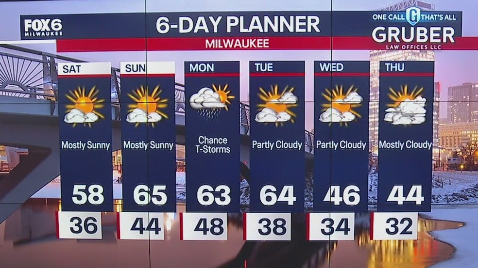
Mostly sunny to sunny skies on Saturday with highs reaching the upper 50s. Southeast wind makes it a little cooler near the lake. Sunday high temps remain in the mid-60s with breezy winds gusting near 30mph. Rain and possible storms return on Monday. Calm days mid-week with cooler temps back in the 40s.
Mostly sunny to sunny skies on Saturday with highs reaching the upper 50s. Southeast wind makes it a little cooler near the lake. Sunday high temps remain in the mid-60s with breezy winds gusting near 30mph. Rain and possible storms return on Monday. Calm days mid-week with cooler temps back in the 40s.

Weather Webcast with Meteorologist Eric Manges
Warm up into the weekend but windy by Sunday
Warm up into the weekend but windy by Sunday

Weather webcast with Rob Haswell
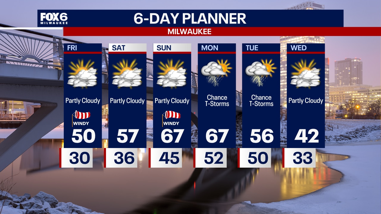
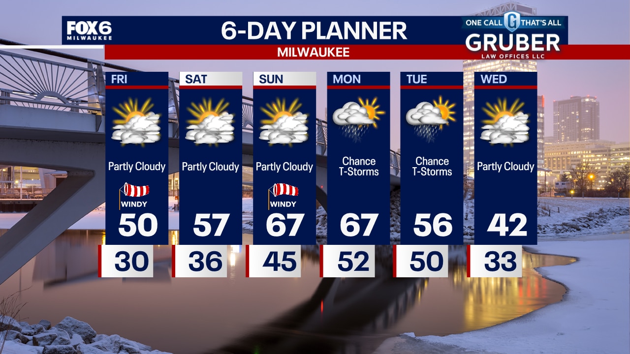
Another sunny start to our day with a steady south wind helping to warm us up nicely. Highs will reach 50 today and get into the 60s this weekend. Rain returns Sunday night into Monday with a slight chance for thunderstorms. More showers are possible Tuesday. We dry up and cool down by Wednesday.
Another sunny start to our day with a steady south wind helping to warm us up nicely. Highs will reach 50 today and get into the 60s this weekend. Rain returns Sunday night into Monday with a slight chance for thunderstorms. More showers are possible Tuesday. We dry up and cool down by Wednesday.
Weather Webcast with Tom Wachs
Clear skies overnight with temperatures around 30 by sunrise. Partly sunny, windy and warmer on Friday with a high around 50. Upper 50s on Saturday and mid-to-upper 60s on Sunday.
Clear skies overnight with temperatures around 30 by sunrise. Partly sunny, windy and warmer on Friday with a high around 50. Upper 50s on Saturday and mid-to-upper 60s on Sunday.
Weather Webcast with Tom Wachs
Clear skies tonight with temperatures dropping through the 30s. Partly sunny, windy and warmer on Friday with a high around 50.
Clear skies tonight with temperatures dropping through the 30s. Partly sunny, windy and warmer on Friday with a high around 50.

Weather webcast with Rob Haswell
High pressure dominates our region today with ample sunshine and a steady warming trend. After a chilly morning, we warm into the low to mid 40s today and into the 50s tomorrow as a warm front pushes through our area. Behind the warm front, we get into the low 60s for the weekend. Cooler air returns later Monday as a cold front passes through. With that passage, we will see a few showers and windy conditions at times.
High pressure dominates our region today with ample sunshine and a steady warming trend. After a chilly morning, we warm into the low to mid 40s today and into the 50s tomorrow as a warm front pushes through our area. Behind the warm front, we get into the low 60s for the weekend. Cooler air returns later Monday as a cold front passes through. With that passage, we will see a few showers and windy conditions at times.
Weather Webcast with Tom Wachs
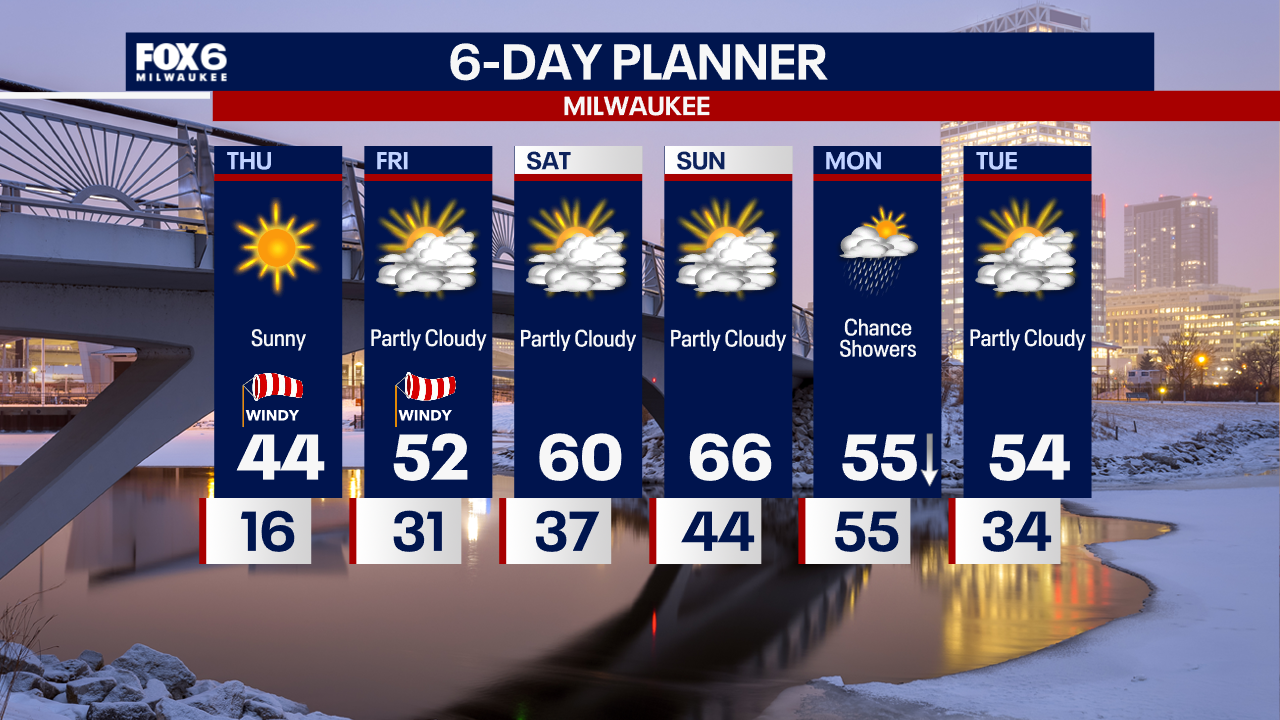
Clear and cold overnight with sunrise temperatures in the teens. Sunny, windy and warmer on Thursday with highs in the low-to-mid 40s.
Clear and cold overnight with sunrise temperatures in the teens. Sunny, windy and warmer on Thursday with highs in the low-to-mid 40s.
Weather Webcast with Tom Wachs
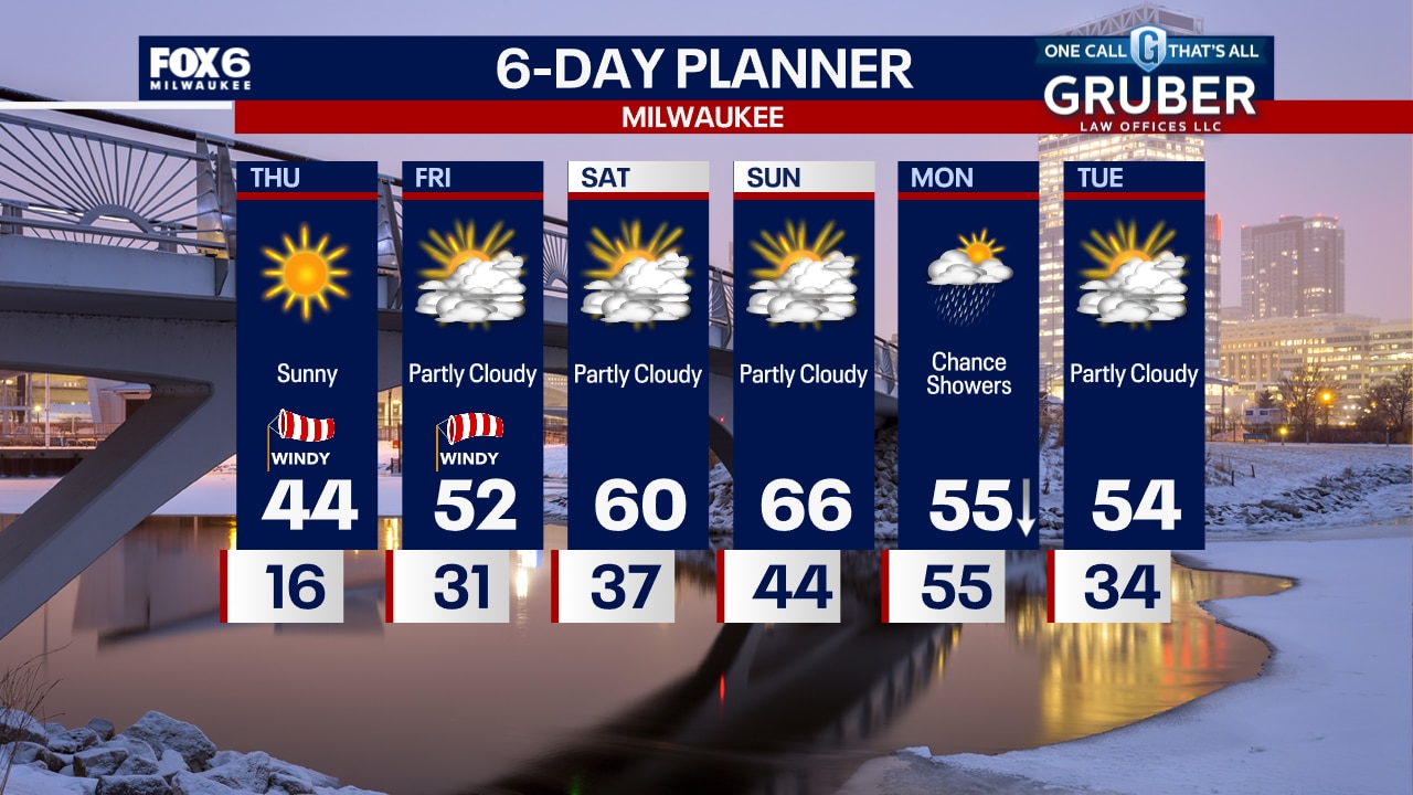
Clear, blustery and cold tonight with temperatures dropping into the teens. Sunny, windy and warmer on Thursday with highs in the 40s.
Clear, blustery and cold tonight with temperatures dropping into the teens. Sunny, windy and warmer on Thursday with highs in the 40s.

Weather webcast with Rob Haswell
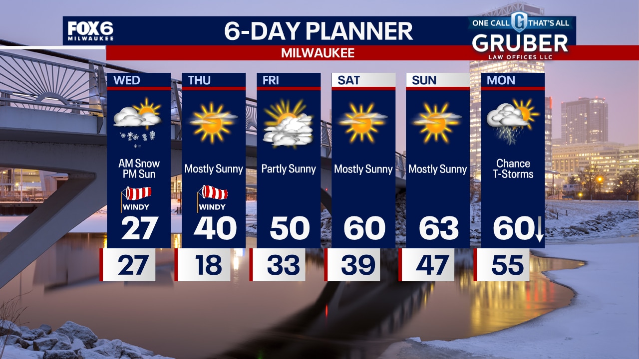
Much colder air continues to flow across our area with temperatures falling into the 20s for today. Light morning snow will dissipate by mid-morning and we clear to sunny conditions this afternoon. After another chilly night tonight, we warm into the 40s Thursday and hit 50 for Friday with 60s returning for the weekend. After this morning snow ends, we stay dry until Monday with rain returning to the area.
Much colder air continues to flow across our area with temperatures falling into the 20s for today. Light morning snow will dissipate by mid-morning and we clear to sunny conditions this afternoon. After another chilly night tonight, we warm into the 40s Thursday and hit 50 for Friday with 60s returning for the weekend. After this morning snow ends, we stay dry until Monday with rain returning to the area.

Weather Webcast with Tom Wachs
T-Storms moving out, snow moving through overnight. 0.50"-1.0" of snow with temperatures dropping below 32 by sunrise. Snowy/icy roads are possible for the Wednesday AM commute.
T-Storms moving out, snow moving through overnight. 0.50"-1.0" of snow with temperatures dropping below 32 by sunrise. Snowy/icy roads are possible for the Wednesday AM commute.
Weather Webcast with Tom Wachs
Severe t-storms possible near the IL border this evening. Tornado Watch for southern areas until 10pm. Snow for everyone overnight, around 0.5". Icy AM commute possible.
Severe t-storms possible near the IL border this evening. Tornado Watch for southern areas until 10pm. Snow for everyone overnight, around 0.5". Icy AM commute possible.

Weather webcast with Rob Haswell
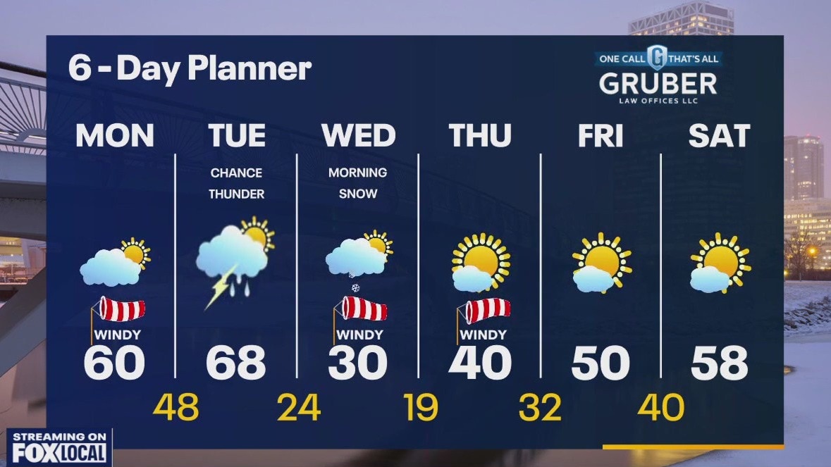
A busy 24 hours begins this morning with record setting heat followed by potentially strong to severe storms and then cold air and snow. Highs today will reach the low 70s and eclipse the previous record high temperature for the date. Rain and thunderstorms arrive later this afternoon and evening with a Marginal to Slight risk for severe storms in our area. Behind the departing low we cool rapidly and will see a quick burst of snow Wednesday morning. Highs will fall from the 70s today into the 20s tomorrow!
A busy 24 hours begins this morning with record setting heat followed by potentially strong to severe storms and then cold air and snow. Highs today will reach the low 70s and eclipse the previous record high temperature for the date. Rain and thunderstorms arrive later this afternoon and evening with a Marginal to Slight risk for severe storms in our area. Behind the departing low we cool rapidly and will see a quick burst of snow Wednesday morning. Highs will fall from the 70s today into the 20s tomorrow!

Weather Webcast with Tom Wachs
A record high around 70 is forecast on Tuesday. T-Storms are possible Tuesday evening with snow early Wednesday morning. A 40? temperature drop is expected Wednesday.
A record high around 70 is forecast on Tuesday. T-Storms are possible Tuesday evening with snow early Wednesday morning. A 40? temperature drop is expected Wednesday.

Weather Webcast with Tom Wachs
Big changes on the way. Record high on Tuesday. T-Storms Tuesday evening and snow Wednesday morning with a 40 degree temperature drop.
Big changes on the way. Record high on Tuesday. T-Storms Tuesday evening and snow Wednesday morning with a 40 degree temperature drop.
Weather webcast with Lisa Michaels
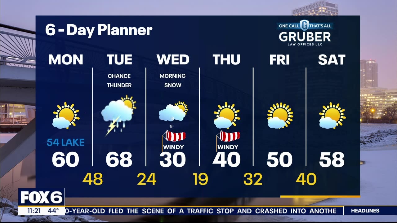
We are between an area of high pressure and an approaching low and it's associated warm front. That will push our temperatures into the 50s and 60s. A steady southeast wind will keep things in the 50s lakeside with 60s farther inland. Very dry air and a strong breeze today and tomorrow has lead to an elevated fire risk for parts of our area. Please always be careful with any outdoor fires or any outdoor activity that could cause sparks. We stay dry today but rain is likely tomorrow with a chance for thunderstorms. There is a Marginal to Slight risk for strong to severe storms in our area.
We are between an area of high pressure and an approaching low and it's associated warm front. That will push our temperatures into the 50s and 60s. A steady southeast wind will keep things in the 50s lakeside with 60s farther inland. Very dry air and a strong breeze today and tomorrow has lead to an elevated fire risk for parts of our area. Please always be careful with any outdoor fires or any outdoor activity that could cause sparks. We stay dry today but rain is likely tomorrow with a chance for thunderstorms. There is a Marginal to Slight risk for strong to severe storms in our area.
Weather webcast with Rob Haswell
We are between an area of high pressure and an approaching low and it's associated warm front. That will push our temperaturs into the 50s and 60s. A steady southeast wind will keep things in the 50s lakeside with 60s farther inland. Very dry air and a strong breeze today and tomorrow has lead to an elevated fire risk for parts of our area. Please always be careful with any outdoor fires or any outdoor activity that could cause sparks. We stay dry today but rain is likely tomorrow with a chance for thunderstorms. There is a Marginal to Slight risk for strong to severe storms in our area.
We are between an area of high pressure and an approaching low and it's associated warm front. That will push our temperaturs into the 50s and 60s. A steady southeast wind will keep things in the 50s lakeside with 60s farther inland. Very dry air and a strong breeze today and tomorrow has lead to an elevated fire risk for parts of our area. Please always be careful with any outdoor fires or any outdoor activity that could cause sparks. We stay dry today but rain is likely tomorrow with a chance for thunderstorms. There is a Marginal to Slight risk for strong to severe storms in our area.