


Weather webcast with Rob Haswell
After a couple of soggy days, we enter a dry and cooler stretch. We get back to sun by this afternoon but temperatures will be in the upper 30s to near 40 and feel cooler with a steady breeze. We warm a bit Thursday and Friday with highs reaching upper 40s to near 50. Rain returns late Friday into Saturday with a lull late Saturday into the first half of Sunday, but rain will return before the sunsets on Easter Sunday.
After a couple of soggy days, we enter a dry and cooler stretch. We get back to sun by this afternoon but temperatures will be in the upper 30s to near 40 and feel cooler with a steady breeze. We warm a bit Thursday and Friday with highs reaching upper 40s to near 50. Rain returns late Friday into Saturday with a lull late Saturday into the first half of Sunday, but rain will return before the sunsets on Easter Sunday.

Weather Webcast with Tom Wachs
Cloudy and windy overnight with temperatures dropping into the 20s. Gradual clearing on Wednesday, windy and cool. Highs in the upper 30s.
Cloudy and windy overnight with temperatures dropping into the 20s. Gradual clearing on Wednesday, windy and cool. Highs in the upper 30s.

Weather Webcast with Tom Wachs
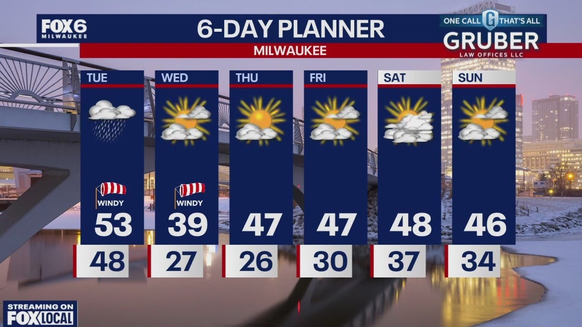
Rain is ending this evening with the wind continuing. Windy tonight with temperatures dropping into the 20s overnight. Clearing skies on Wednesday, windy and cool with highs in the upper 30s.
Rain is ending this evening with the wind continuing. Windy tonight with temperatures dropping into the 20s overnight. Clearing skies on Wednesday, windy and cool with highs in the upper 30s.
Weather webcast with Lisa Michaels
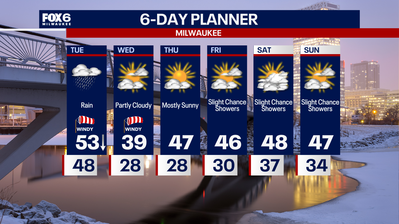
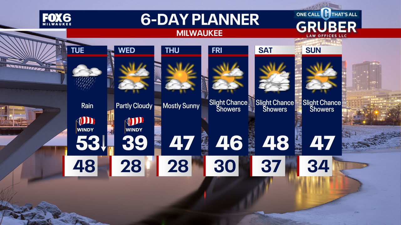
Rain showers continue this morning with a few moderate to heavier showers closer to noon prior to the cold front passing. Isolated thunder is possible. Gradually drying out by this afternoon. Highs will occur midday in the low 50s and dropping into the 40s by the afternoon hours. Windy with gusts 30-40mph. Colder air moves in on Wednesday with highs in the upper 30s and sunshine returning. More sunshine on Thursday with seasonable highs in the upper 40s.
Rain showers continue this morning with a few moderate to heavier showers closer to noon prior to the cold front passing. Isolated thunder is possible. Gradually drying out by this afternoon. Highs will occur midday in the low 50s and dropping into the 40s by the afternoon hours. Windy with gusts 30-40mph. Colder air moves in on Wednesday with highs in the upper 30s and sunshine returning. More sunshine on Thursday with seasonable highs in the upper 40s.
Weather Webcast with Tom Wachs
Rainy overnight with the wind picking up. Scattered showers and a few rumbles possible on Tuesday morning and midday. Rain will taper off Tuesday afternoon.
Rainy overnight with the wind picking up. Scattered showers and a few rumbles possible on Tuesday morning and midday. Rain will taper off Tuesday afternoon.
Weather Webcast with Tom Wachs
Rainy all evening into the overnight. Temperatures around 50. Scattered showers and t-storms Tuesday morning and midday, tapering off in the afternoon. We'll reach a midday high in the low-to-mid 50s.
Rainy all evening into the overnight. Temperatures around 50. Scattered showers and t-storms Tuesday morning and midday, tapering off in the afternoon. We'll reach a midday high in the low-to-mid 50s.

Weather webcast with Rob Haswell
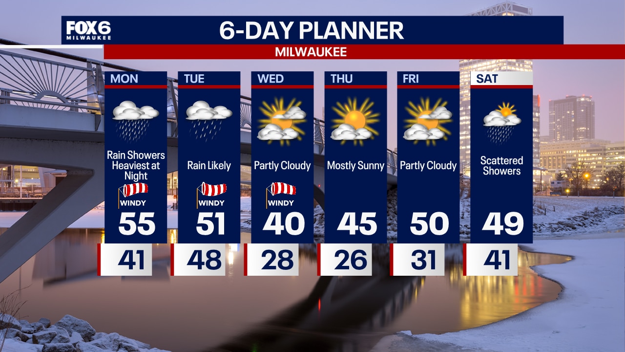
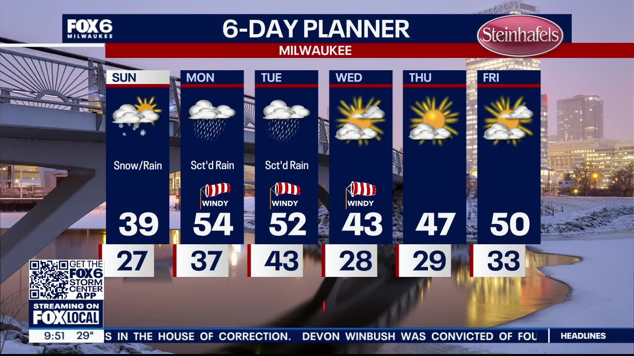
A warm front pushes to our north today with a notable warm up but it also brings rain. Around 1/2 an inch is likely today with more tonight. High will be in the low to mid 50s today and mid to upper 50 tomorrow before the cold front drops us back into the low 40s by Wednesday. We remain sunny but cooler than average through the late week. Rain returns for Friday night and into the weekend.
A warm front pushes to our north today with a notable warm up but it also brings rain. Around 1/2 an inch is likely today with more tonight. High will be in the low to mid 50s today and mid to upper 50 tomorrow before the cold front drops us back into the low 40s by Wednesday. We remain sunny but cooler than average through the late week. Rain returns for Friday night and into the weekend.
Weather Webcast with Tom Wachs
Windy overnight with temperatures in the upper 30s to low 40s. Off-and-on rain showers on Monday with a windy high in the mid-50s. Steady rain moves in Monday evening.
Windy overnight with temperatures in the upper 30s to low 40s. Off-and-on rain showers on Monday with a windy high in the mid-50s. Steady rain moves in Monday evening.

Weather Webcast with Tom Wachs
Snow will continue moving north out of the area tonight as we dry out and stay windy. Temperatures will gradually rise into the low 40s by morning. Off-and-on rain on Monday, windy with highs in the mid-50s.
Snow will continue moving north out of the area tonight as we dry out and stay windy. Temperatures will gradually rise into the low 40s by morning. Off-and-on rain on Monday, windy with highs in the mid-50s.

Weather webcast with Lisa Michaels
Light morning snow flurries/showers. A dusting to half an inch possible in areas. Otherwise mid 20s to low 30s Sunday morning under cloudy skies. Upper 30s on Sunday starting off dry in the day for most. Slushy snow will be brief along I-94 and north Sunday afternoon before changing over to rain Sunday night. Snow could cause a quick dusting to 1" north near Fond du Lac. Heavier showers and even a few storms possible Monday into Tuesday.
Light morning snow flurries/showers. A dusting to half an inch possible in areas. Otherwise mid 20s to low 30s Sunday morning under cloudy skies. Upper 30s on Sunday starting off dry in the day for most. Slushy snow will be brief along I-94 and north Sunday afternoon before changing over to rain Sunday night. Snow could cause a quick dusting to 1" north near Fond du Lac. Heavier showers and even a few storms possible Monday into Tuesday.
Weather webcast with Lisa Michaels
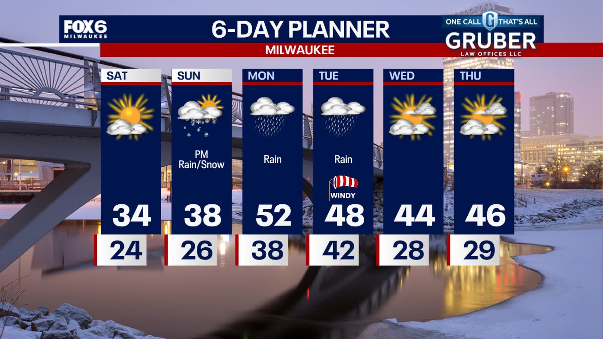
Clouds increase Saturday night into early Sunday. Temperatures drop into the mid to upper 20s early then warm near sunrise. Chance of light snow showers west of I-41. Dusting to half an inch possible early Sunday morning. Any untreated pavement can refreeze and become icy. Upper 30s on Sunday starting off dry for most of the day. During the afternoon, slushy snow will be brief along I-94 and north Sunday early evening. Transitioning to rain on Monday and Tuesday of next week.
Clouds increase Saturday night into early Sunday. Temperatures drop into the mid to upper 20s early then warm near sunrise. Chance of light snow showers west of I-41. Dusting to half an inch possible early Sunday morning. Any untreated pavement can refreeze and become icy. Upper 30s on Sunday starting off dry for most of the day. During the afternoon, slushy snow will be brief along I-94 and north Sunday early evening. Transitioning to rain on Monday and Tuesday of next week.

Weather webcast with Lisa Michaels
Mostly sunny Saturday with high temps in the mid 30s. Clouds increase Saturday night into early Sunday. Chance of light snow showers west of I-41. Dusting to half an inch possible. Any untreated pavement can refreeze and become icy. Upper 30s on Sunday starting off dry. Slushy snow will be brief along I-94 and north Sunday night. Transitioning to rain on Monday and Tuesday of next week.
Mostly sunny Saturday with high temps in the mid 30s. Clouds increase Saturday night into early Sunday. Chance of light snow showers west of I-41. Dusting to half an inch possible. Any untreated pavement can refreeze and become icy. Upper 30s on Sunday starting off dry. Slushy snow will be brief along I-94 and north Sunday night. Transitioning to rain on Monday and Tuesday of next week.
Weather Webcast with Stephanie Barichello
The snow has ended and now clouds will clear by early tomorrow morning, allowing temperatures to drop into the 20s. Any untreated pavement will become icy! Calm and cool Saturday then there is another chance for slushy snow and mix Sunday afternoon. Rain is then likely Monday and Tuesday.
The snow has ended and now clouds will clear by early tomorrow morning, allowing temperatures to drop into the 20s. Any untreated pavement will become icy! Calm and cool Saturday then there is another chance for slushy snow and mix Sunday afternoon. Rain is then likely Monday and Tuesday.

Weather webcast with Rob Haswell
A Winter Weather Advisory is in effect until 4 p.m. Friday. We can expect heavy snow at times throughout the morning and midday. Several inches of accumulation will be possible, although highest totals could be within a narrow band. We dry out late today and into Saturday. Another system brings us a wintry mix Sunday then transitions to a soaking rain Monday into Tuesday.
A Winter Weather Advisory is in effect until 4 p.m. Friday. We can expect heavy snow at times throughout the morning and midday. Several inches of accumulation will be possible, although highest totals could be within a narrow band. We dry out late today and into Saturday. Another system brings us a wintry mix Sunday then transitions to a soaking rain Monday into Tuesday.

Weather Webcast with Tom Wachs
A snowstorm moves in overnight and continues into early-to-mid afternoon on Friday. 3-6" of snow with locally higher amounts possible. Please take it slow on the roads Friday.
A snowstorm moves in overnight and continues into early-to-mid afternoon on Friday. 3-6" of snow with locally higher amounts possible. Please take it slow on the roads Friday.

Weather Webcast with Tom Wachs
Snow moves in after 12am and really picks up by the morning commute. Snow continues all morning and tapers off by mid-afternoon. 3-6" in most areas.
Snow moves in after 12am and really picks up by the morning commute. Snow continues all morning and tapers off by mid-afternoon. 3-6" in most areas.

Weather Webcast with Stephanie Barichello
Cloudy and cool today then snow moves in after midnight, staying steady then through midday Friday. Expect heavy snow, low visibility and slushy accumulation on roads throughout the day. Improving later in the afternoon as snow winds down. Sunny and cold Saturday then another round of wintry mix by late Sunday. It changes to rain Monday and Tuesday.
Cloudy and cool today then snow moves in after midnight, staying steady then through midday Friday. Expect heavy snow, low visibility and slushy accumulation on roads throughout the day. Improving later in the afternoon as snow winds down. Sunny and cold Saturday then another round of wintry mix by late Sunday. It changes to rain Monday and Tuesday.

Weather webcast with Rob Haswell
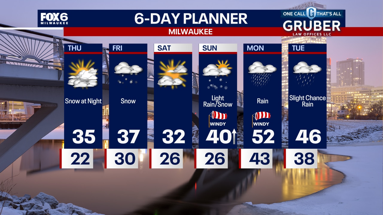
Ahead of a winter storm, we now have a Winter Weather Advisory issued for all of southeastern and south central Wisconsin. The advisory goes into effect Friday morning. Snow will start overnight Thursday and end Friday afternoon. Several inches of snow are possible. We get to dry up on Saturday but rain and snow return Sunday and we get quite windy. Over an inch worth of rain is possible Monday into Tuesday with warmer temperatures returning.
Ahead of a winter storm, we now have a Winter Weather Advisory issued for all of southeastern and south central Wisconsin. The advisory goes into effect Friday morning. Snow will start overnight Thursday and end Friday afternoon. Several inches of snow are possible. We get to dry up on Saturday but rain and snow return Sunday and we get quite windy. Over an inch worth of rain is possible Monday into Tuesday with warmer temperatures returning.

Weather Webcast with Tom Wachs
Increasing clouds overnight with temperatures in the teens and 20s. Mostly cloudy on Thursday with highs in the 30s. Snow moves in late Thursday night and especially on Friday morning.
Increasing clouds overnight with temperatures in the teens and 20s. Mostly cloudy on Thursday with highs in the 30s. Snow moves in late Thursday night and especially on Friday morning.
Weather Webcast with Tom Wachs
Clear skies this evening with increasing clouds overnight. Temperatures dropping into the 20s and even teens away from the lake overnight. Dry on Thursday. Snow moves in Friday morning.
Clear skies this evening with increasing clouds overnight. Temperatures dropping into the 20s and even teens away from the lake overnight. Dry on Thursday. Snow moves in Friday morning.