


Weather webcast with Rob Haswell
High pressure builds across our area today and for the weekend. We will be clear this morning but become partly cloudy for a period this afternoon. Wind gusts will be strong today at times from the NW and that will help usher in some cooler air. Highs today will be in the low 50s and stay in the low 50s for Saturday before warming back to the 60s Sunday and early next week.
High pressure builds across our area today and for the weekend. We will be clear this morning but become partly cloudy for a period this afternoon. Wind gusts will be strong today at times from the NW and that will help usher in some cooler air. Highs today will be in the low 50s and stay in the low 50s for Saturday before warming back to the 60s Sunday and early next week.

Weather Webcast with Tom Wachs
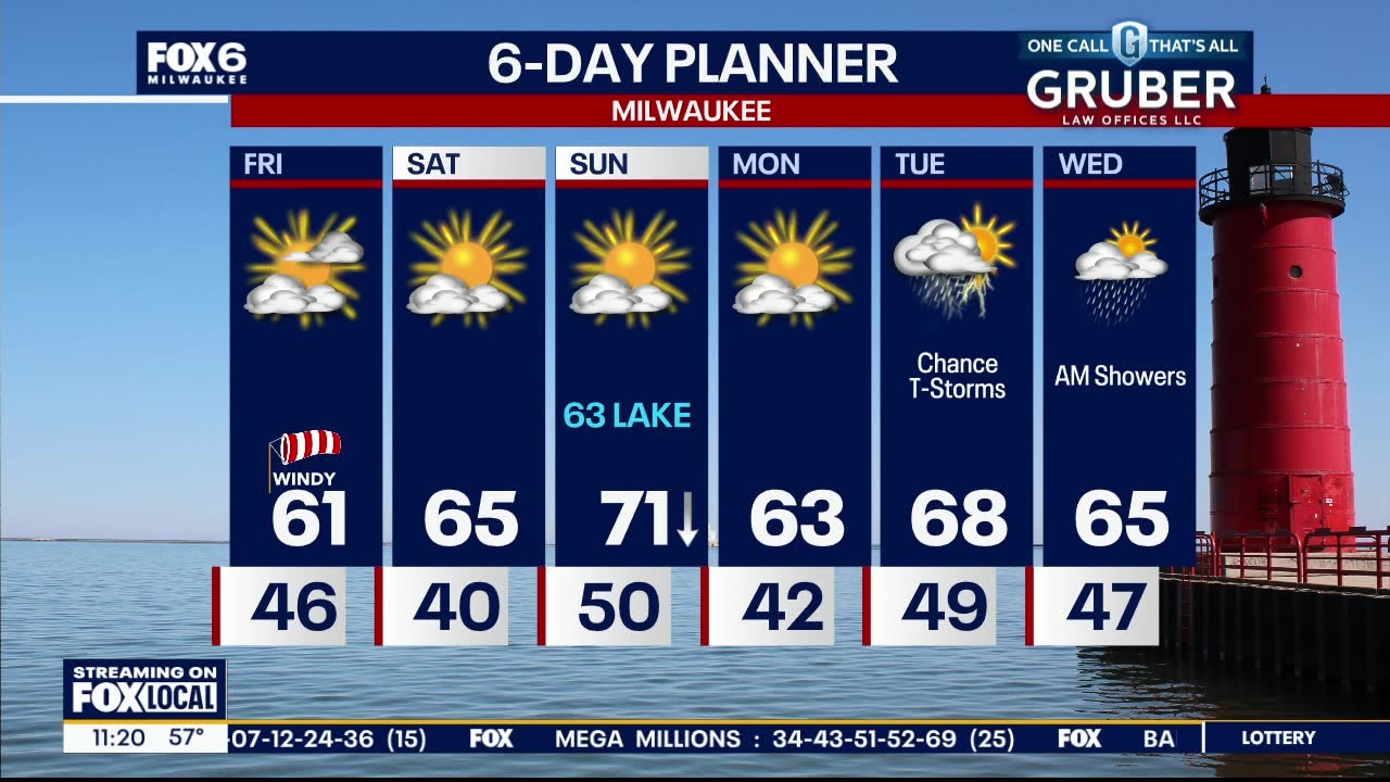
The sun returns on Friday along with strong westerly winds. The wind will gust as high as 40mph during the day with highs in the mid-50s.
The sun returns on Friday along with strong westerly winds. The wind will gust as high as 40mph during the day with highs in the mid-50s.

Weather Webcast with Tom Wachs
Rain moving through this evening coming to an end by 12am. The sun returns on Friday but it will be windy with highs in the low-to-mid 50s.
Rain moving through this evening coming to an end by 12am. The sun returns on Friday but it will be windy with highs in the low-to-mid 50s.

Weather webcast with Rob Haswell
A narrow ridge of high pressure has us clear and dry early today but a low passes to our south later today with more rain for our area. We can expect an additional 0.25 - 0.33 today. Rain will end late evening and we clear up Friday and into the weekend. Cooler air arrives today with highs in the low to mid 50s likely today and through Saturday. We will be in the upper 50s to low 60s early next week. We stay dry through the weekend but rain returns by Tuesday.
A narrow ridge of high pressure has us clear and dry early today but a low passes to our south later today with more rain for our area. We can expect an additional 0.25 - 0.33 today. Rain will end late evening and we clear up Friday and into the weekend. Cooler air arrives today with highs in the low to mid 50s likely today and through Saturday. We will be in the upper 50s to low 60s early next week. We stay dry through the weekend but rain returns by Tuesday.

Weather Webcast with Tom Wachs
Rain moves in from the west on Thursday morning and continues on-and-off throughout the day. Not as windy with highs in the low 50s. The sun returns on Friday.
Rain moves in from the west on Thursday morning and continues on-and-off throughout the day. Not as windy with highs in the low 50s. The sun returns on Friday.

Weather Webcast with Tom Wachs
Windy this evening with temperatures in the 50s. The wind will subside overnight with temperatures dropping into the 40s. Rain returns on Thursday with highs in the low 50s.
Windy this evening with temperatures in the 50s. The wind will subside overnight with temperatures dropping into the 40s. Rain returns on Thursday with highs in the low 50s.

Weather webcast with Rob Haswell
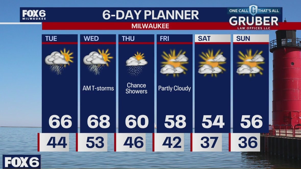
Early morning thunderstorms to kick off our Wednesday but we settle to a few showers this afternoon. A strong wind as the occluded front of the storm low passes through. We will be in the mid to upper 60s this afternoon but behind the front we cool into the 50s for Thursday and through the weekend. A few more showers are expected on Thursday before we dry up Friday and into next week.
Early morning thunderstorms to kick off our Wednesday but we settle to a few showers this afternoon. A strong wind as the occluded front of the storm low passes through. We will be in the mid to upper 60s this afternoon but behind the front we cool into the 50s for Thursday and through the weekend. A few more showers are expected on Thursday before we dry up Friday and into next week.

Weather Webcast with Tom Wachs
Showers and t-storm end overnight. Windy with temperatures in the 50s. Another batch of strong storms is possible between 6-10am otherwise windy with highs in the 60s on Wednesday.
Showers and t-storm end overnight. Windy with temperatures in the 50s. Another batch of strong storms is possible between 6-10am otherwise windy with highs in the 60s on Wednesday.

Weather Webcast with Tom Wachs
Showers and possibly strong t-storms through midnight tonight. Wind and hail will be the main threats. Another batch of strong storms possible Wednesday AM, otherwise windy with lingering afternoon rain showers.
Showers and possibly strong t-storms through midnight tonight. Wind and hail will be the main threats. Another batch of strong storms possible Wednesday AM, otherwise windy with lingering afternoon rain showers.

Weather webcast with Stephanie Barichello
Increasing clouds today with thunderstorms likely by early evening, lasting through about midnight in spots. Storms could become severe with primarily large hail and strong wind, but far southwest communities could see an isolated tornado.
Increasing clouds today with thunderstorms likely by early evening, lasting through about midnight in spots. Storms could become severe with primarily large hail and strong wind, but far southwest communities could see an isolated tornado.
Weather webcast with Rob Haswell
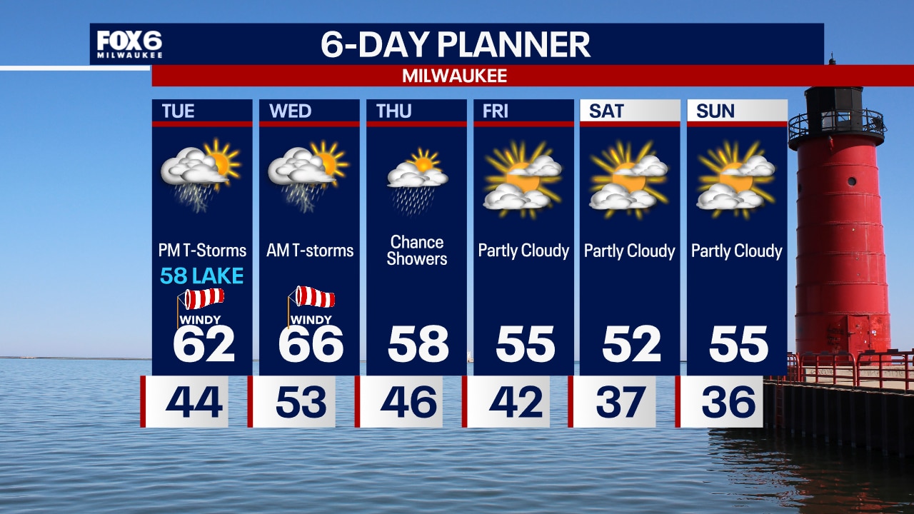
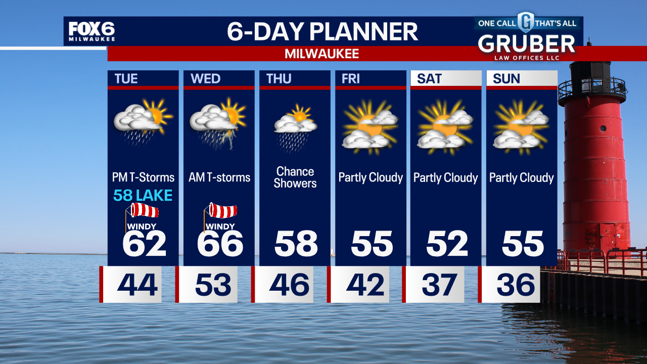
We are tracking a low and its warm front today and tonight. That system will generate rain and thunderstorms later today and tonight. There is a Marginal to Slight risk for severe storms today. While tornadoes are possible with this system, the greater risk will likely be strong straight line winds, hail and heavy rain leading to flooding. Many areas will receive an inch or more with of rain today and early tomorrow. We dry up later this week.
We are tracking a low and its warm front today and tonight. That system will generate rain and thunderstorms later today and tonight. There is a Marginal to Slight risk for severe storms today. While tornadoes are possible with this system, the greater risk will likely be strong straight line winds, hail and heavy rain leading to flooding. Many areas will receive an inch or more with of rain today and early tomorrow. We dry up later this week.
Weather Webcast with Tom Wachs
Clear skies overnight with temperatures in the 40s. Increasing clouds on Tuesday, windy with highs in the upper 50s to low 60s. T-Storms move in late afternoon into Tuesday night.
Clear skies overnight with temperatures in the 40s. Increasing clouds on Tuesday, windy with highs in the upper 50s to low 60s. T-Storms move in late afternoon into Tuesday night.
Weather Webcast with Tom Wachs
Clear skies tonight with temperatures falling into the 40s overnight. Increasing clouds on Tuesday, windy with highs in the upper 50s to low 60s. T-Storm chances return late in the afternoon & especially at night.
Clear skies tonight with temperatures falling into the 40s overnight. Increasing clouds on Tuesday, windy with highs in the upper 50s to low 60s. T-Storm chances return late in the afternoon & especially at night.
Weather webcast with Rob Haswell
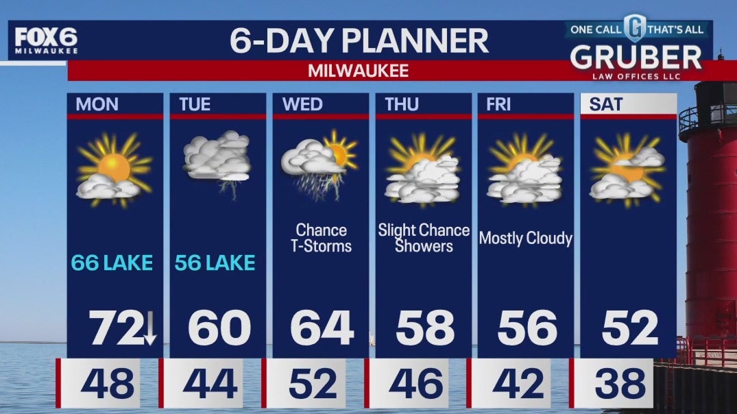
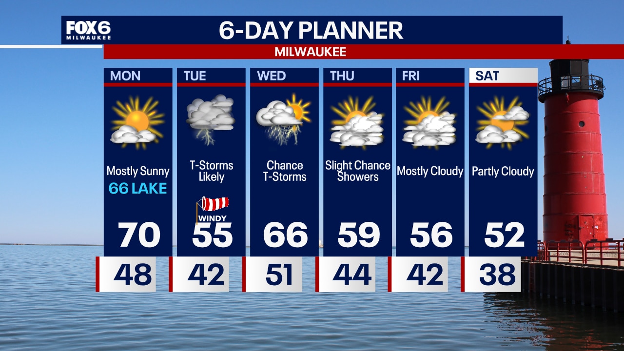
Another mild and sunny day today as an area of high pressure continues its hold over the area. A breeze develops off of Lake Michigan later today to keep things in the 60s near the lake while inland areas return to the 70s. We are tracking a strong low for later this week. Rain and thunderstorms are expected by later Tuesday evening and continue into Wednesday. Depending on arrival time and track of the low, we could see strong to severe storms in our area during that time. Stay weather aware and tune in for updates.
Another mild and sunny day today as an area of high pressure continues its hold over the area. A breeze develops off of Lake Michigan later today to keep things in the 60s near the lake while inland areas return to the 70s. We are tracking a strong low for later this week. Rain and thunderstorms are expected by later Tuesday evening and continue into Wednesday. Depending on arrival time and track of the low, we could see strong to severe storms in our area during that time. Stay weather aware and tune in for updates.
Weather Webcast with Tom Wachs
Clear overnight with temperatures in the 40s. Mostly sunny on Monday with highs around 70 Waukesha and west, mid-60s near the lake. T-Storm chances return on Tuesday.
Clear overnight with temperatures in the 40s. Mostly sunny on Monday with highs around 70 Waukesha and west, mid-60s near the lake. T-Storm chances return on Tuesday.
Weather webcast with Lisa Michaels
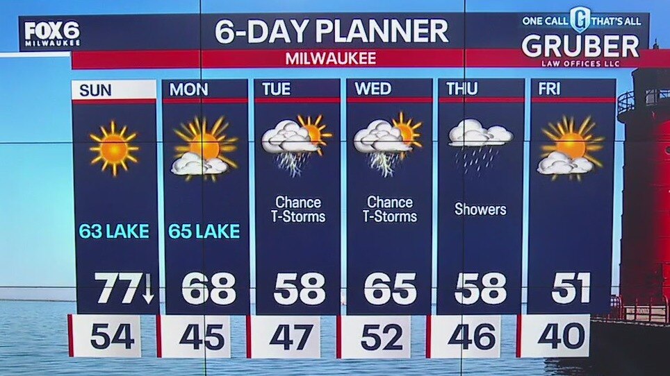
Warmest day of year so far with highs reaching the mid to upper 70s inland. Isolated 80F possible. It will be cooler near the lake due to a shift in winds this afternoon. Sunshine continues on Sunday and Monday. Chance of strong to severe storms possible Tuesday afternoon. Rain showers will still be possible at times Wednesday and Thursday.
Warmest day of year so far with highs reaching the mid to upper 70s inland. Isolated 80F possible. It will be cooler near the lake due to a shift in winds this afternoon. Sunshine continues on Sunday and Monday. Chance of strong to severe storms possible Tuesday afternoon. Rain showers will still be possible at times Wednesday and Thursday.
Weather webcast with Lisa Michaels
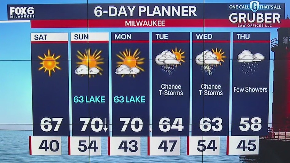
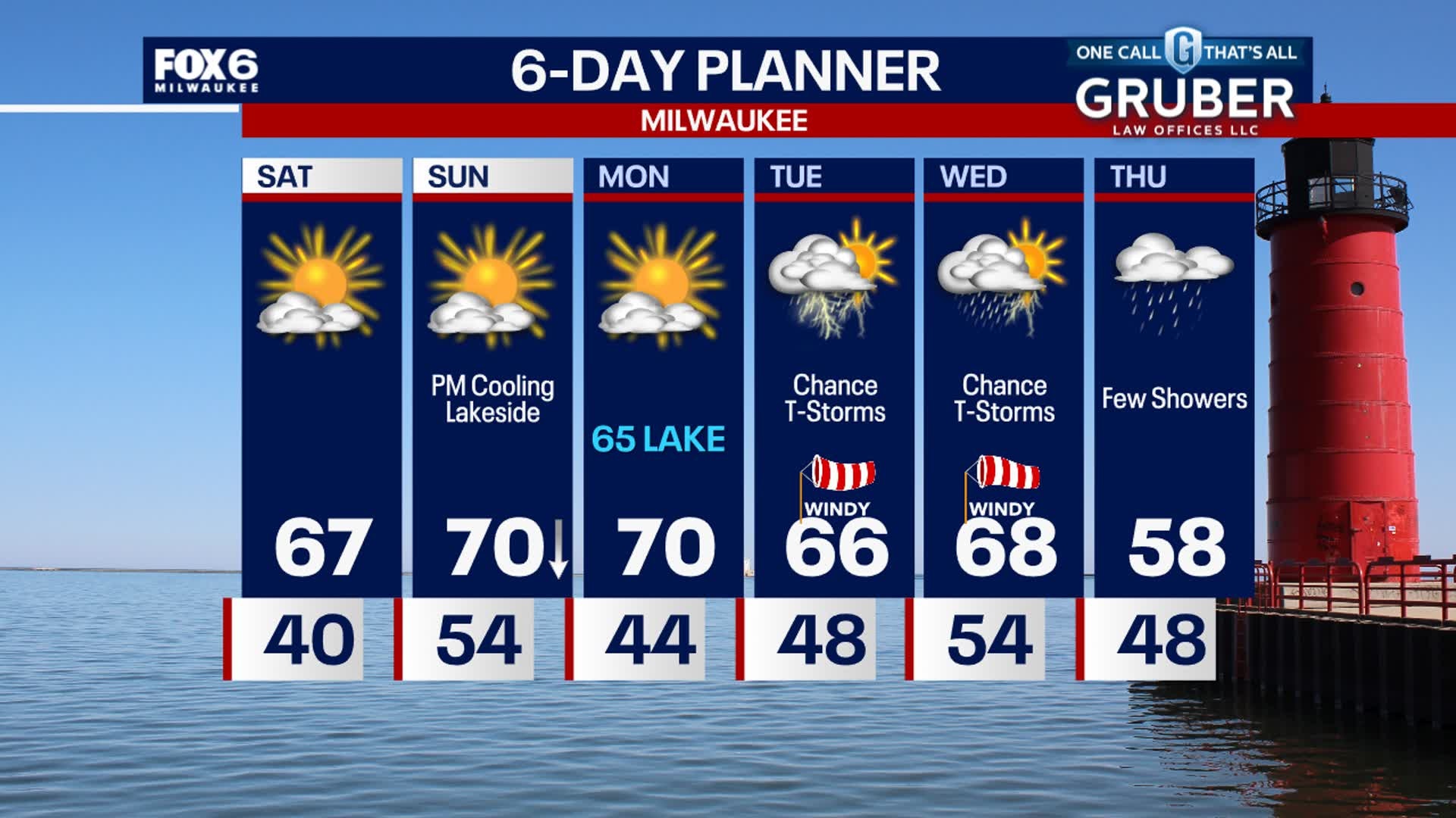
Mostly sunny Saturday with highs in the upper 60s. Sunshine continues on Sunday with highs in the low 70s inland and low 60s lakeside. Watching for a chance of rain/storms that could be strong to severe on Tuesday. Rain showers will still be possible at times Wednesday and Thursday.
Mostly sunny Saturday with highs in the upper 60s. Sunshine continues on Sunday with highs in the low 70s inland and low 60s lakeside. Watching for a chance of rain/storms that could be strong to severe on Tuesday. Rain showers will still be possible at times Wednesday and Thursday.
Weather Webcast with Stephanie Barichello
Drying out this evening after some pop-up showers and storms this afternoon. A gorgeous weekend ahead with sunshine and temperatures in the 60s and 70s, although expect dropping temperatures Sunday afternoon and a cold front turns the wind off of the lake. Stormy by Tuesday, already a threat for severe weather.
Drying out this evening after some pop-up showers and storms this afternoon. A gorgeous weekend ahead with sunshine and temperatures in the 60s and 70s, although expect dropping temperatures Sunday afternoon and a cold front turns the wind off of the lake. Stormy by Tuesday, already a threat for severe weather.
Weather webcast with Lisa Michaels
Strong winds on Friday with gusts could be between 30-40mph. Sunny and warmer over the weekend.Temperatures will likely drop lakeside during the afternoons. Thunderstorms return Tuesday into Wednesday morning and the warmth sticks around.
Strong winds on Friday with gusts could be between 30-40mph. Sunny and warmer over the weekend.Temperatures will likely drop lakeside during the afternoons. Thunderstorms return Tuesday into Wednesday morning and the warmth sticks around.

Weather webcast with Lisa Michaels
Light drizzle/rain Friday morning. Otherwise, clearing out by the afternoon with partly cloudy skies. Highs in the upper 50s. Strong winds on Friday with gusts could be between 30-40mph. Sunny and warmer over the weekend. Temperatures will likely drop lakeside during the afternoons. Thunderstorms return Tuesday into Wednesday morning and the warmth sticks around.
Light drizzle/rain Friday morning. Otherwise, clearing out by the afternoon with partly cloudy skies. Highs in the upper 50s. Strong winds on Friday with gusts could be between 30-40mph. Sunny and warmer over the weekend. Temperatures will likely drop lakeside during the afternoons. Thunderstorms return Tuesday into Wednesday morning and the warmth sticks around.