


Weather webcast with Stephanie Barichello
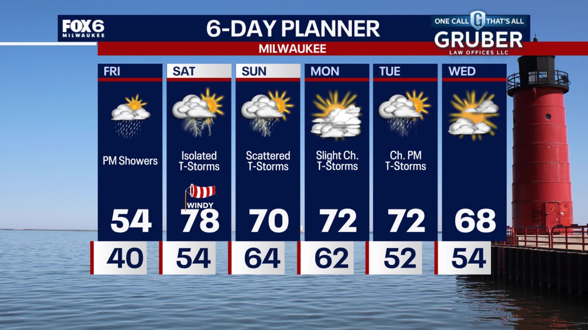
Rain showers continue this evening, with a greater chance for thunderstorms late tonight. Temperatures will rise overnight with an incoming warm front, which will then get us into the upper 70s on Saturday!
Rain showers continue this evening, with a greater chance for thunderstorms late tonight. Temperatures will rise overnight with an incoming warm front, which will then get us into the upper 70s on Saturday!

Weather webcast with Rob Haswell
We are tracking an area of low pressure and its warm front as it moves our way from the west and southwest. That low will bring us rain and and thunderstorms today, starting in the afternoon and lasting into the overnight. Another round of rain and thunderstorms is expected Saturday and again on Sunday. Temperatures will be near normal today but cooler near the lake. We warm into the upper 70s tomorrow and stay in the upper 60s and 70s most of next week.
We are tracking an area of low pressure and its warm front as it moves our way from the west and southwest. That low will bring us rain and and thunderstorms today, starting in the afternoon and lasting into the overnight. Another round of rain and thunderstorms is expected Saturday and again on Sunday. Temperatures will be near normal today but cooler near the lake. We warm into the upper 70s tomorrow and stay in the upper 60s and 70s most of next week.
Weather Webcast with Stephanie Barichello
Clear skies tonight and warmer, then rain chances return Friday afternoon. Round of thunderstorms then possible over the weekend, all possibly severe at times. Temperatures will also be much warmer, nearing 80 on Saturday!
Clear skies tonight and warmer, then rain chances return Friday afternoon. Round of thunderstorms then possible over the weekend, all possibly severe at times. Temperatures will also be much warmer, nearing 80 on Saturday!

Weather webcast with Rob Haswell
A Freeze Warning is in effect until 8am this morning with temperatures in the upper 20s and low 30s. We stay sunny today and will warm from the chilly morning lows to highs in the low to mid 50s this afternoon. A low arrives on Friday with rain likely and a chance for thunderstorms. Around 0.25 to .75" of rain possible. More rain on the way for Saturday and into Sunday. Wind gusts will be strong Friday through Sunday.
A Freeze Warning is in effect until 8am this morning with temperatures in the upper 20s and low 30s. We stay sunny today and will warm from the chilly morning lows to highs in the low to mid 50s this afternoon. A low arrives on Friday with rain likely and a chance for thunderstorms. Around 0.25 to .75" of rain possible. More rain on the way for Saturday and into Sunday. Wind gusts will be strong Friday through Sunday.

Weather Webcast with Tom Wachs
Freeze Warning through 8am. Temperatures in the upper 20s to low 30s by sunrise. Mostly sunny on Thursday with highs in the low 50s near the lake, upper 50s inland.
Freeze Warning through 8am. Temperatures in the upper 20s to low 30s by sunrise. Mostly sunny on Thursday with highs in the low 50s near the lake, upper 50s inland.

Weather Webcast with Tom Wachs
Freeze Warnings overnight. Temperatures in the upper 20s to low 30s by sunrise. Mostly sunny and a little warmer Thursday. Highs in the 50s. Rain chances return Friday.
Freeze Warnings overnight. Temperatures in the upper 20s to low 30s by sunrise. Mostly sunny and a little warmer Thursday. Highs in the 50s. Rain chances return Friday.

Weather webcast with Lisa Michaels
Mostly sunny Wednesday with highs in the low 40s lakeside and upper 40s inland. Warming back into the mid/upper 50s on Thursday and Friday.
Mostly sunny Wednesday with highs in the low 40s lakeside and upper 40s inland. Warming back into the mid/upper 50s on Thursday and Friday.

Weather Webcast with Tom Wachs
A BIG temperature drop across the area on Tuesday evening. There was a 15 degree drop in one hour in Milwaukee. Temperatures in the 30s by morning. Mostly sunny and windy on Wednesday with highs in the 40s.
A BIG temperature drop across the area on Tuesday evening. There was a 15 degree drop in one hour in Milwaukee. Temperatures in the 30s by morning. Mostly sunny and windy on Wednesday with highs in the 40s.

Weather Webcast with Tom Wachs
Isolated showers and t-storms possible this evening. A big temperature drop is on the way overnight as lows dip into the 30s. Mostly sunny, windy and cool on Wednesday with highs in the 40s.
Isolated showers and t-storms possible this evening. A big temperature drop is on the way overnight as lows dip into the 30s. Mostly sunny, windy and cool on Wednesday with highs in the 40s.
Weather webcast with Lisa Michaels
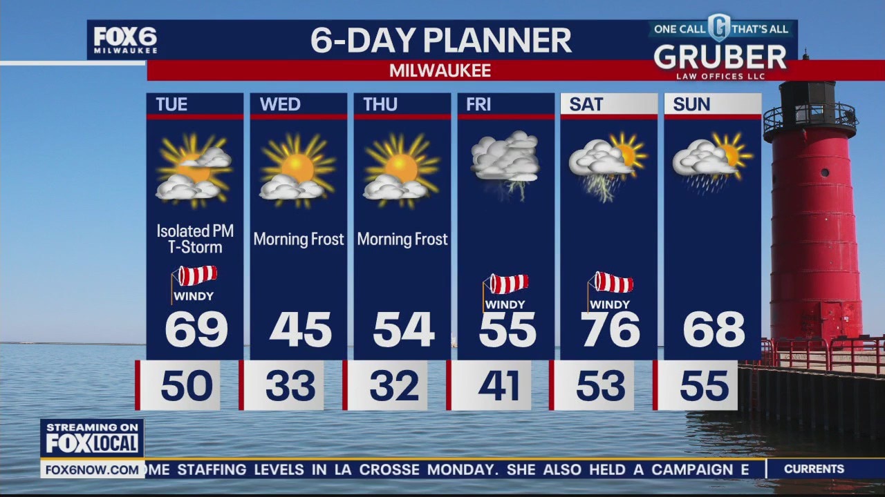
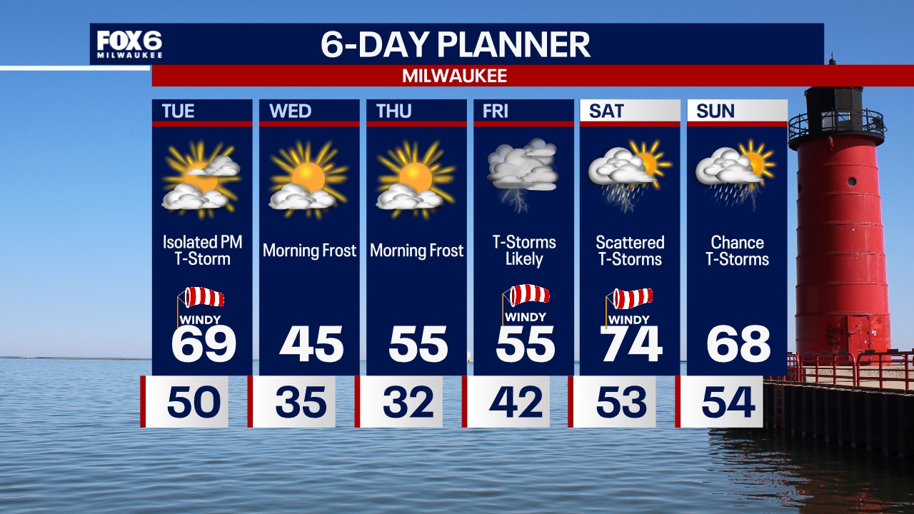
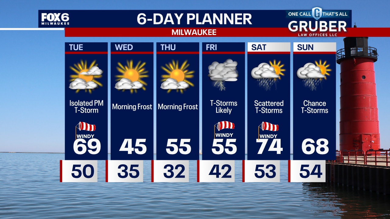
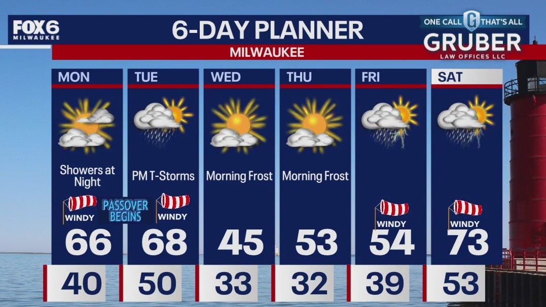
Partly to mostly cloudy on Tuesday. Windy and warm with temps in the upper 60s to70F. Isolated rain/storms develop in the late afternoon. An isolated storm could have gusty winds and small hail. (isolated chance of a strong storm after 4pm) Temperatures dramatically drop to around freezing Wednesday morning with patchy frost, then we only reach into the 40s in the afternoon. Still cool Thursday then temperatures rise into the 60s and 70s by the weekend. Thunderstorms are possible Friday, Saturday and Sunday.
Partly to mostly cloudy on Tuesday. Windy and warm with temps in the upper 60s to70F. Isolated rain/storms develop in the late afternoon. An isolated storm could have gusty winds and small hail. (isolated chance of a strong storm after 4pm) Temperatures dramatically drop to around freezing Wednesday morning with patchy frost, then we only reach into the 40s in the afternoon. Still cool Thursday then temperatures rise into the 60s and 70s by the weekend. Thunderstorms are possible Friday, Saturday and Sunday.
Weather Webcast with Tom Wachs
Windy overnight with a few light rain showers ending. Temperatures around 50. Windy and warm again on Tuesday with a few late day isolated t-storms possible. Highs in the upper 60s.
Windy overnight with a few light rain showers ending. Temperatures around 50. Windy and warm again on Tuesday with a few late day isolated t-storms possible. Highs in the upper 60s.
Weather Webcast with Tom Wachs
Light rain showers are possible between 8pm and 1am, otherwise windy and mild tonight. Temperatures dropping through the 50s. Windy and warm on Tuesday with an isolated late day t-storm possible. Highs between 65-70.
Light rain showers are possible between 8pm and 1am, otherwise windy and mild tonight. Temperatures dropping through the 50s. Windy and warm on Tuesday with an isolated late day t-storm possible. Highs between 65-70.
Weather webcast with Lisa Michaels
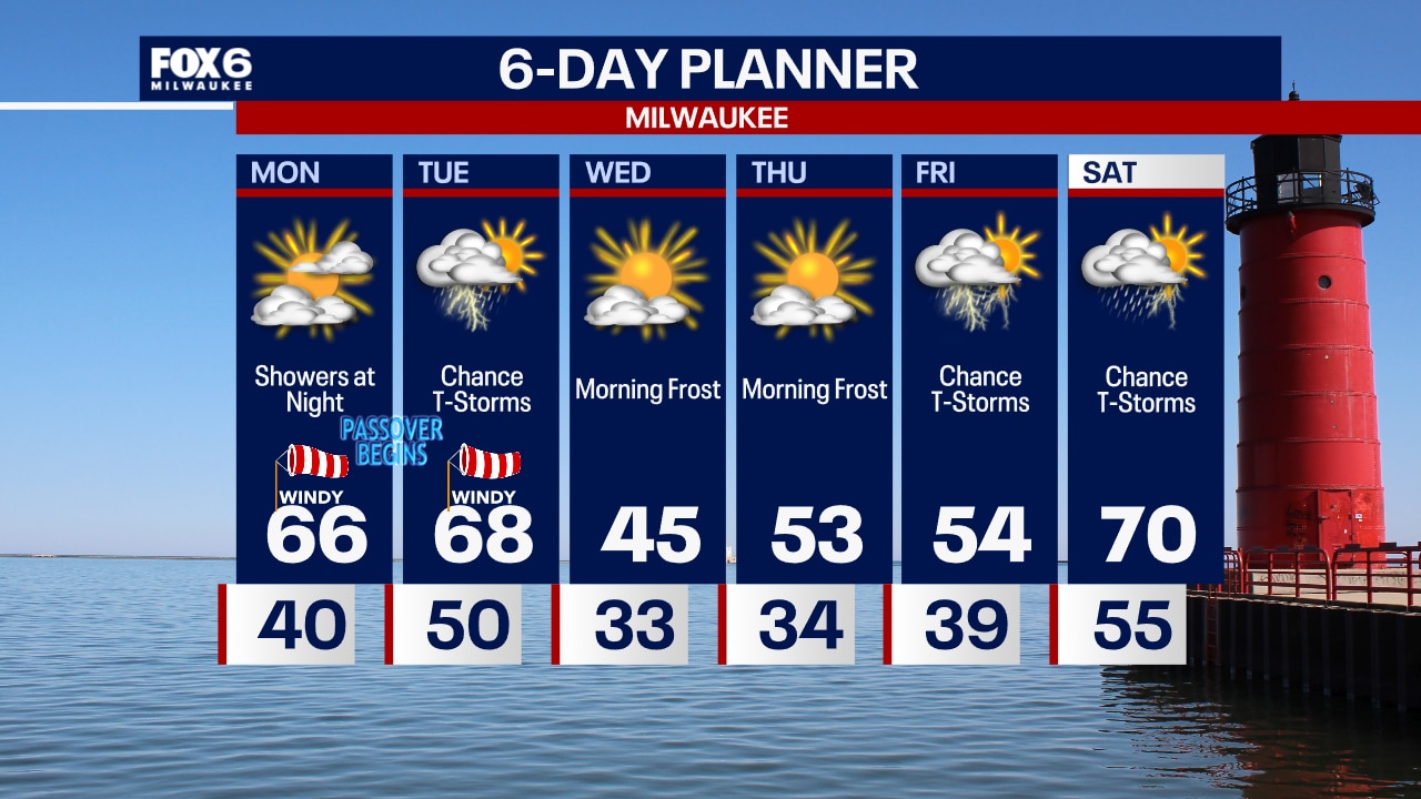
Increasing cloud cover on Monday with highs in the mid 60s. Breezy with gusts near 30 mph. Rain and storm chances increase tonight. There will be a dry period on Tuesday early with more rain/storms entering by Tuesday afternoon and evening. A big temperature drop in store for Wednesday where highs will be back in the mid 40s. Watching another large warm-up swing in the 70s by Saturday with the chance of stronger storms.
Increasing cloud cover on Monday with highs in the mid 60s. Breezy with gusts near 30 mph. Rain and storm chances increase tonight. There will be a dry period on Tuesday early with more rain/storms entering by Tuesday afternoon and evening. A big temperature drop in store for Wednesday where highs will be back in the mid 40s. Watching another large warm-up swing in the 70s by Saturday with the chance of stronger storms.
Weather Webcast with Tom Wachs
Clear skies overnight with temperatures in the upper 30s to around 40s by sunrise. Windy and warmer Monday with highs in the mid-60s. Light rain showers move in by evening.
Clear skies overnight with temperatures in the upper 30s to around 40s by sunrise. Windy and warmer Monday with highs in the mid-60s. Light rain showers move in by evening.

Weather Webcast with Tom Wachs
Clear skies tonight with temperatures falling into the 40s. Windy and warmer on Monday with highs in the mid-60s. Rain chances return Monday evening.
Clear skies tonight with temperatures falling into the 40s. Windy and warmer on Monday with highs in the mid-60s. Rain chances return Monday evening.

Weather webcast with Lisa Michaels
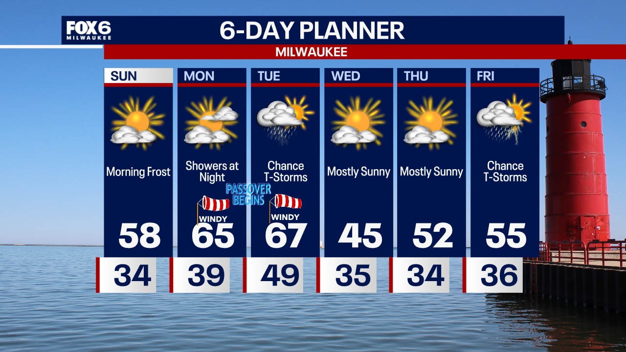
Mostly sunny Sunday with highs warmer in the mid to upper 50s. Temperatures continue to warm into the mid 60s Monday and Tuesday. Chances of rain and storms increase Monday night through Tuesday. Cooler air is back by Wednesday with highs in the mid 40s.
Mostly sunny Sunday with highs warmer in the mid to upper 50s. Temperatures continue to warm into the mid 60s Monday and Tuesday. Chances of rain and storms increase Monday night through Tuesday. Cooler air is back by Wednesday with highs in the mid 40s.
Weather Webcast with Tom Wachs
Freeze Warning away from the lake 12am-8am Sunday. Clearing skies overnight with temperatures falling to 30-35 by morning. Mostly sunny and warmer on Sunday with highs in the mid-to-upper 50s.
Freeze Warning away from the lake 12am-8am Sunday. Clearing skies overnight with temperatures falling to 30-35 by morning. Mostly sunny and warmer on Sunday with highs in the mid-to-upper 50s.

Weather Webcast with Tom Wachs
Freeze Warning away from the lake overnight. Clearing skies. Temperatures dropping to 30-35 by morning. Lots of sun on Sunday with highs in the upper 50s and a blustery WNW wind.
Freeze Warning away from the lake overnight. Clearing skies. Temperatures dropping to 30-35 by morning. Lots of sun on Sunday with highs in the upper 50s and a blustery WNW wind.

Weather webcast with Lisa Michaels
Increasing cloud cover today with a few sprinkles possible this afternoon. Highs in the mid to upper 40s on Saturday. Windy at times with gusts up to 25mph. Even warmer on Sunday with high temps in the upper 50s to 60F. Next chance of rain will be Monday night into Tuesday morning. A second system brings rain Tuesday afternoon into Tuesday night. A few storms are possible as well.
Increasing cloud cover today with a few sprinkles possible this afternoon. Highs in the mid to upper 40s on Saturday. Windy at times with gusts up to 25mph. Even warmer on Sunday with high temps in the upper 50s to 60F. Next chance of rain will be Monday night into Tuesday morning. A second system brings rain Tuesday afternoon into Tuesday night. A few storms are possible as well.

Weather webcast with Stephanie Barichello
Mostly clear tonight with temperatures dropping into the low 30s. Patchy frost will be possible, especially inland. A few clouds throughout Saturday, plus breezy and cool.
Mostly clear tonight with temperatures dropping into the low 30s. Patchy frost will be possible, especially inland. A few clouds throughout Saturday, plus breezy and cool.