

Weather webcast with Rob Haswell
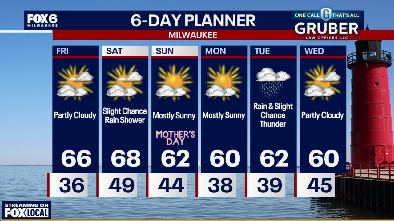
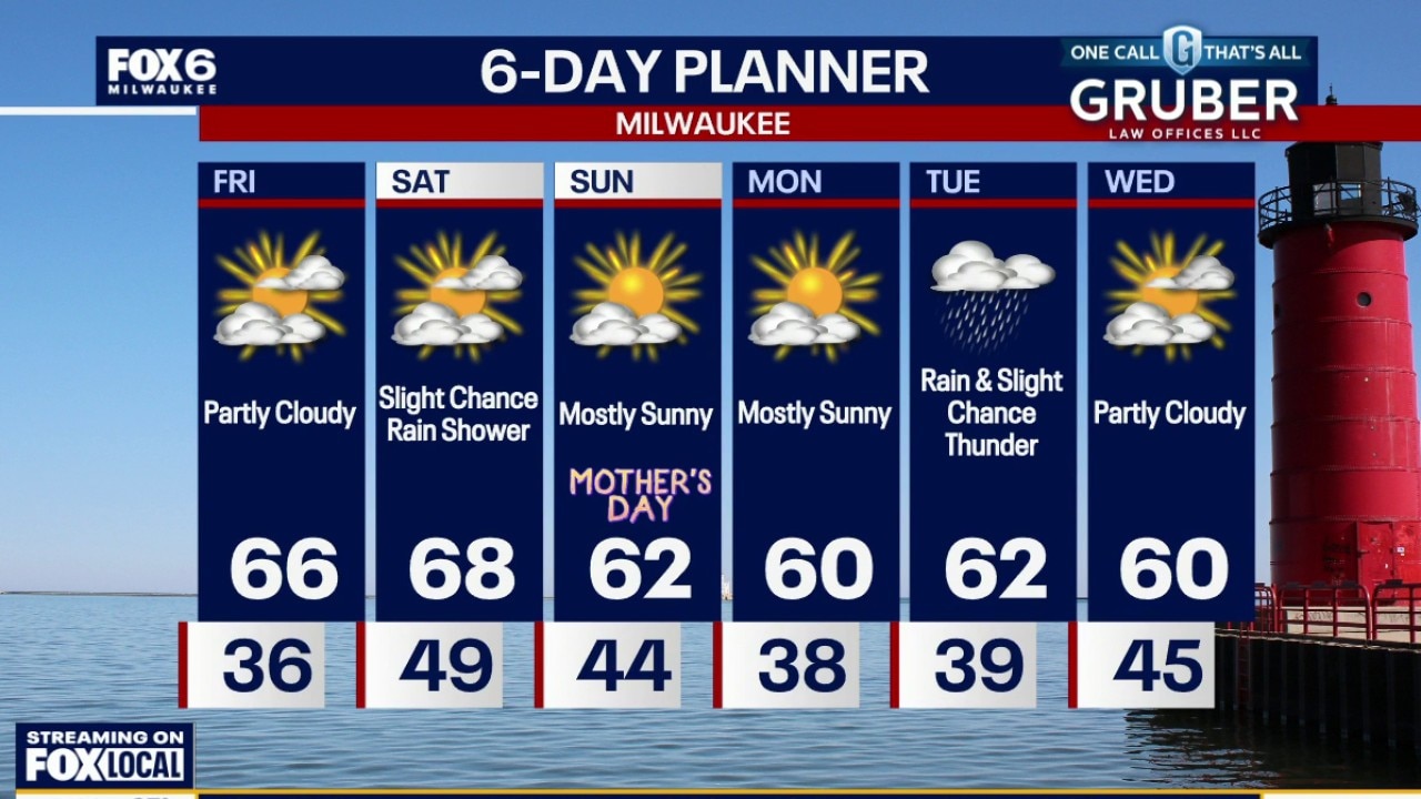
Southern Wisconsin is heading into a much milder stretch with highs warming well into the 60s and even flirting with 70 inland by Saturday. Quiet weather sticks around through the weekend and into Monday. The next meaningful chance for rain arrives late Monday night into Tuesday.
Southern Wisconsin is heading into a much milder stretch with highs warming well into the 60s and even flirting with 70 inland by Saturday. Quiet weather sticks around through the weekend and into Monday. The next meaningful chance for rain arrives late Monday night into Tuesday.
Weather webcast with Rob Haswell
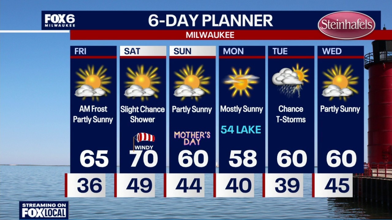
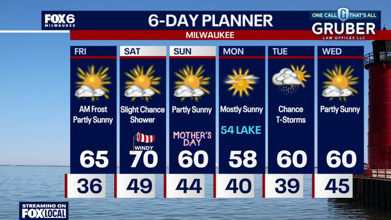
After another frosty start Friday morning, southern Wisconsin is heading into a much milder stretch with highs warming well into the 60s and even flirting with 70 inland by Saturday.
After another frosty start Friday morning, southern Wisconsin is heading into a much milder stretch with highs warming well into the 60s and even flirting with 70 inland by Saturday.
Weather Webcast with Chief Meteorologist Tom Wachs
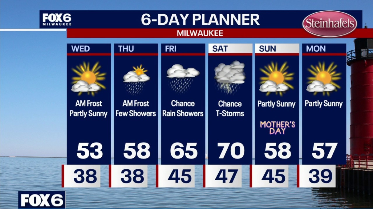
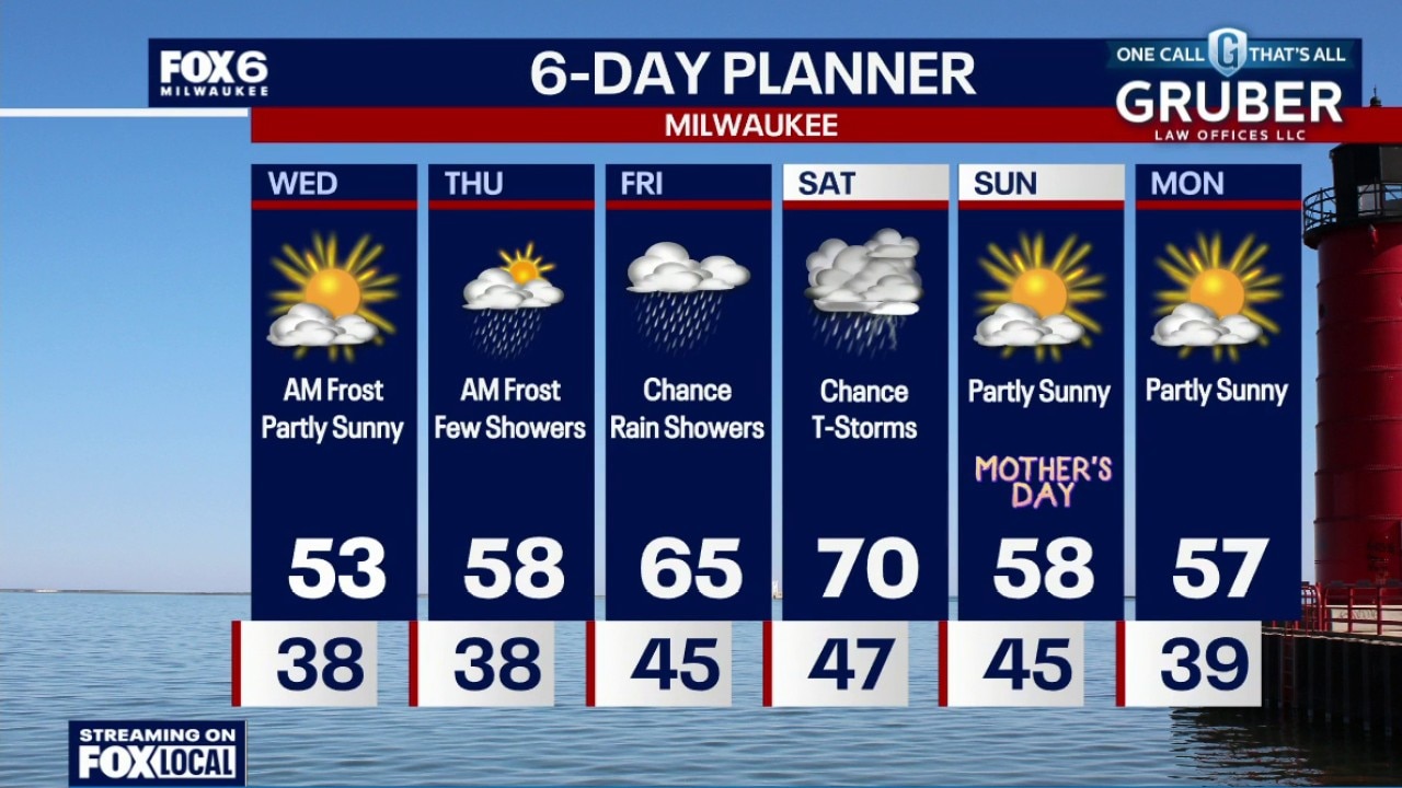
Frost Advisory 1am-8am Friday for all of SE WI Clear skies and cold once again overnight. Temperatures will settle in the 30s by sunrise with frost likely by morning. Partly sunny on Friday, breezy and warmer with an afternoon high in the mid-60s.
Frost Advisory 1am-8am Friday for all of SE WI Clear skies and cold once again overnight. Temperatures will settle in the 30s by sunrise with frost likely by morning. Partly sunny on Friday, breezy and warmer with an afternoon high in the mid-60s.
Weather Webcast with Chief Meteorologist Tom Wachs
Another Frost Advisory in effect for ALL OF SE WI from 1am-8am on Friday. Warming up on Friday afternoon with highs in the mid-60s.
Another Frost Advisory in effect for ALL OF SE WI from 1am-8am on Friday. Warming up on Friday afternoon with highs in the mid-60s.
Weather webcast with Stephanie Barichello
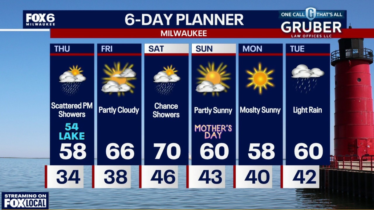
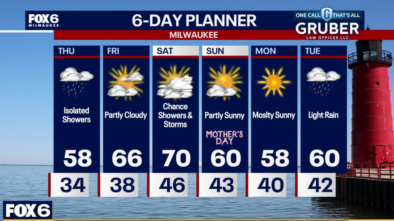
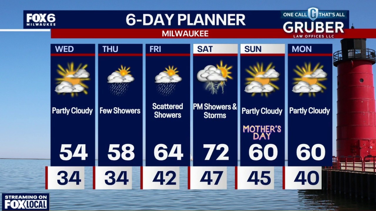
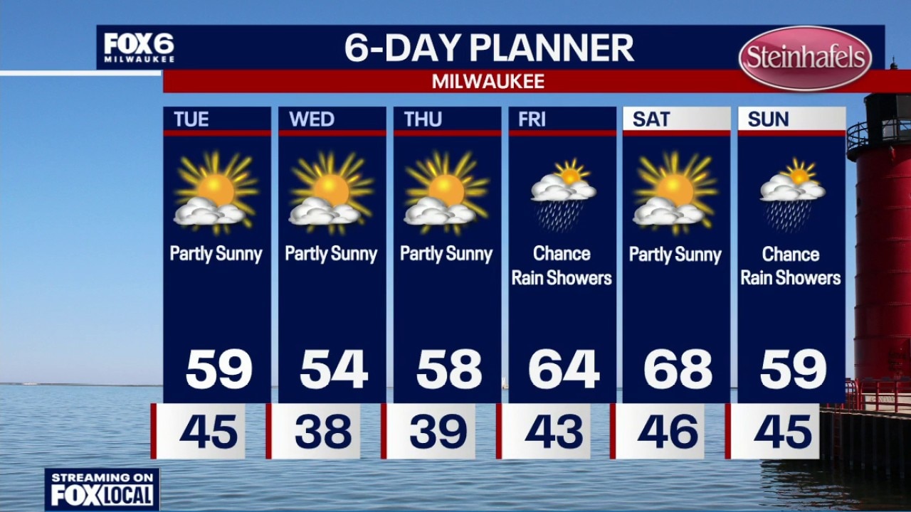
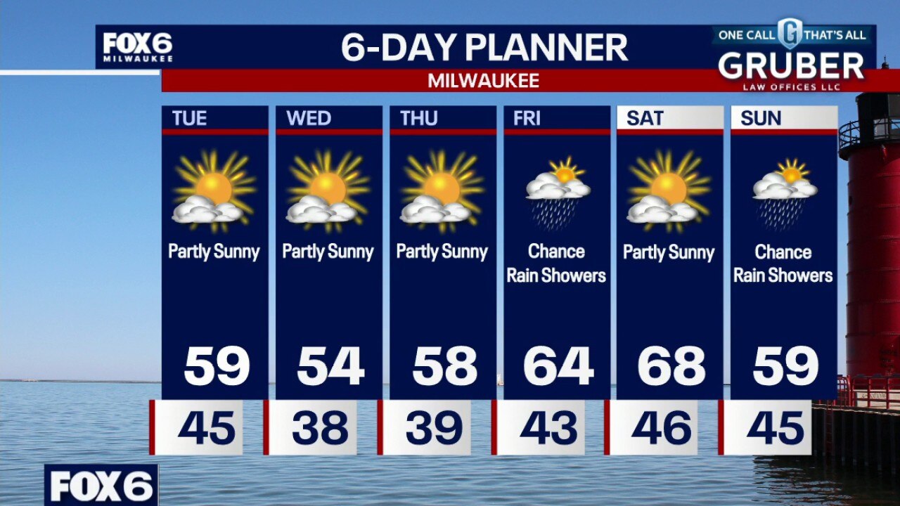
A few scattered afternoon "popcorn" showers are possible Thursday afternoon but the overall pattern stays pretty quiet. Temperatures steadily recover heading into the weekend, with Friday climbing into the mid 60s and Saturday likely topping out near 70 before a cooler push returns Sunday.
A few scattered afternoon "popcorn" showers are possible Thursday afternoon but the overall pattern stays pretty quiet. Temperatures steadily recover heading into the weekend, with Friday climbing into the mid 60s and Saturday likely topping out near 70 before a cooler push returns Sunday.
Weather webcast with Rob Haswell
Southern Wisconsin is still dealing with widespread frost early this morning. A few scattered afternoon "popcorn" showers are possible Thursday afternoon but the overall pattern stays pretty quiet.
Southern Wisconsin is still dealing with widespread frost early this morning. A few scattered afternoon "popcorn" showers are possible Thursday afternoon but the overall pattern stays pretty quiet.
Weather Webcast with Chief Meteorologist Tom Wachs
Frost Advisory 1am-8am Thursday for all of SE WI. Partly cloudy overnight with temperatures falling into the 30s by sunrise. Frosty again by morning.
Frost Advisory 1am-8am Thursday for all of SE WI. Partly cloudy overnight with temperatures falling into the 30s by sunrise. Frosty again by morning.
Weather Webcast with Chief Meteorologist Tom Wachs
Frost Advisory 1am-8am Thursday for all of SE WI
Frost Advisory 1am-8am Thursday for all of SE WI
Weather Webcast with Stephanie Barichello
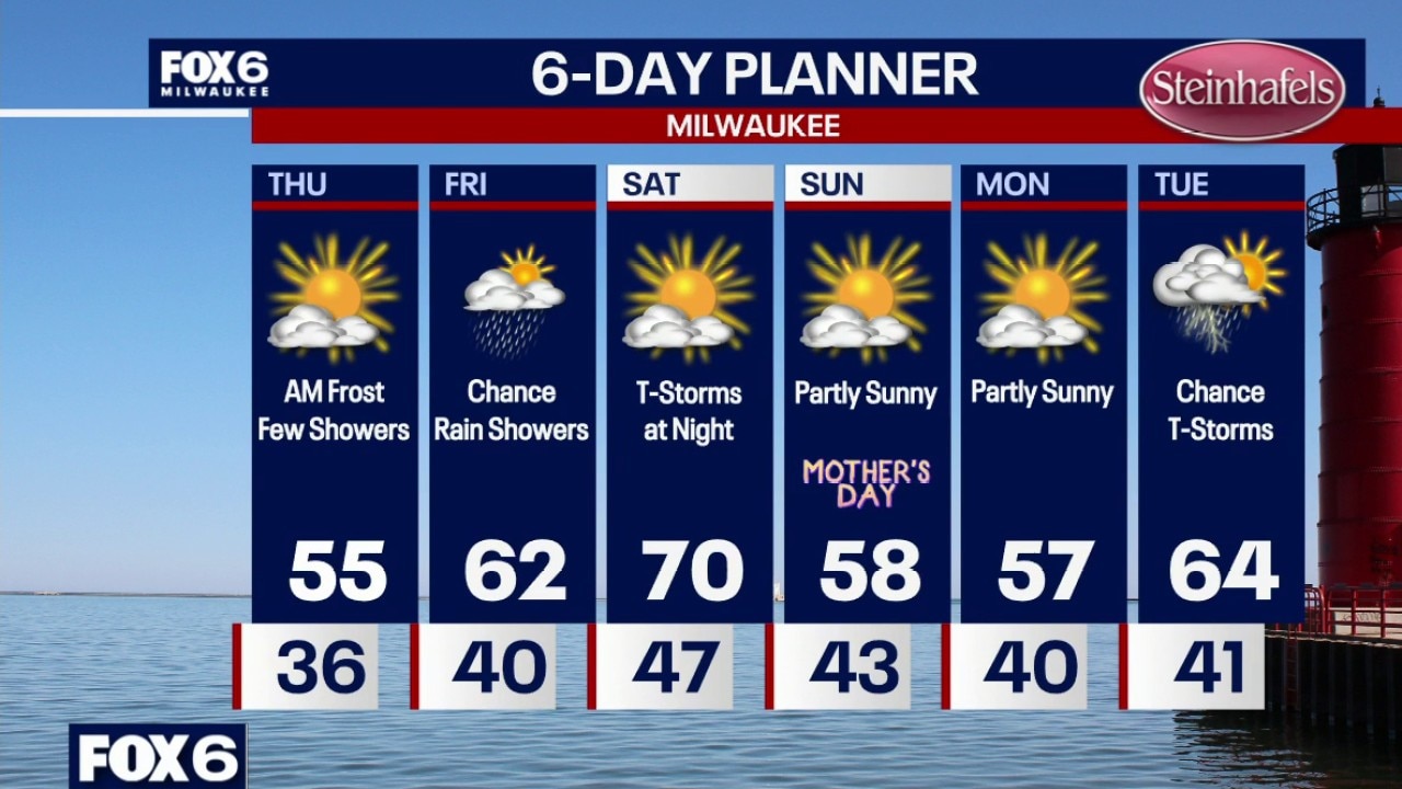
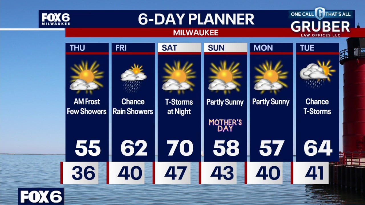
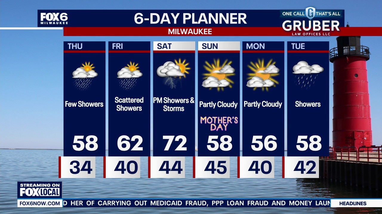
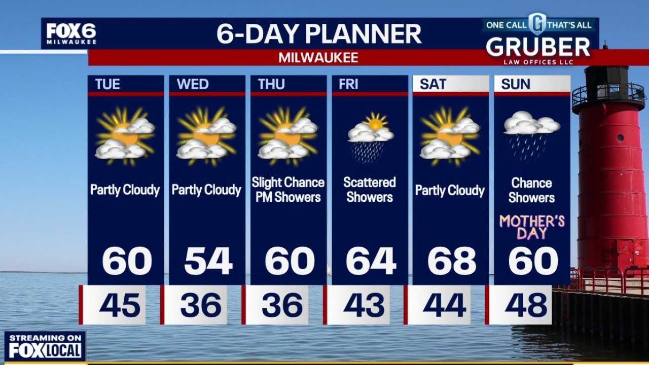
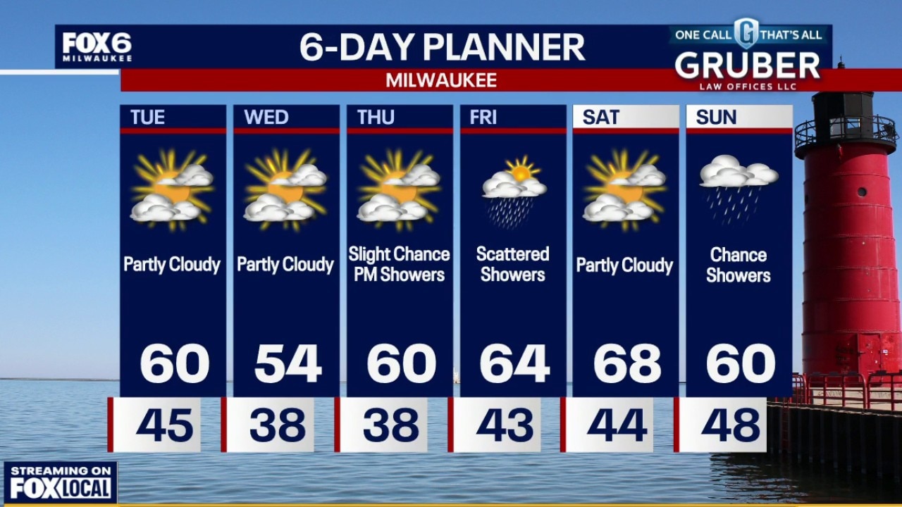
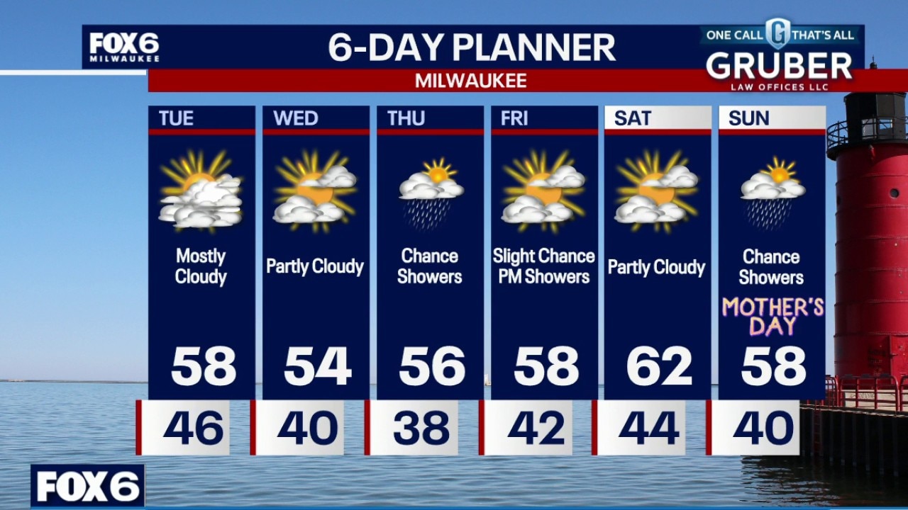
Frost Advisory tonight as temperatures drop into the low 30s. Scattered rain showers possible Thursday and Friday, then a chance of thunderstorms late Saturday along a cold front. Mother's Day is trending dry, just a bit cooler.
Frost Advisory tonight as temperatures drop into the low 30s. Scattered rain showers possible Thursday and Friday, then a chance of thunderstorms late Saturday along a cold front. Mother's Day is trending dry, just a bit cooler.

Weather webcast with Stephanie Barichello
We stay stuck in a cool spring pattern for a couple more days, with widespread frost concerns continuing through Thursday morning, especially inland away from Lake Michigan.
We stay stuck in a cool spring pattern for a couple more days, with widespread frost concerns continuing through Thursday morning, especially inland away from Lake Michigan.
Weather webcast with Rob Haswell
We stay stuck in a cool spring pattern for a couple more days, with widespread frost concerns continuing through Thursday morning, especially inland away from Lake Michigan.
We stay stuck in a cool spring pattern for a couple more days, with widespread frost concerns continuing through Thursday morning, especially inland away from Lake Michigan.
Weather Webcast with Chief Meteorologist Tom Wachs
Frost Advisory 1am-8am Wednesday for ALL of SE WI
Frost Advisory 1am-8am Wednesday for ALL of SE WI
Weather Webcast with Chief Meteorologist Tom Wachs
Frost Advisory 1am-8am Wednesday for Waukesha, Jefferson, Washington, Dodge, Sheboygan and Fond du Lac counties
Frost Advisory 1am-8am Wednesday for Waukesha, Jefferson, Washington, Dodge, Sheboygan and Fond du Lac counties
Weather webcast with Stephanie Barichello
Cooler air has settled into Wisconsin and it is sticking around through much of the week. The big story early on is the return of frost potential, especially inland each night through Thursday, which could lead to advisories or warnings.
Cooler air has settled into Wisconsin and it is sticking around through much of the week. The big story early on is the return of frost potential, especially inland each night through Thursday, which could lead to advisories or warnings.
Weather webcast with Rob Haswell
Cooler air has settled into Wisconsin and it is sticking around through much of the week. The big story early on is the return of frost potential, especially inland each night through Thursday, which could lead to advisories or warnings.
Cooler air has settled into Wisconsin and it is sticking around through much of the week. The big story early on is the return of frost potential, especially inland each night through Thursday, which could lead to advisories or warnings.
Weather Webcast with Chief Meteorologist Tom Wachs
Partly to mostly cloudy and cooler overnight. Temperatures will drop into the 40s by sunrise. Partly sunny and much cooler on Tuesday with highs in the upper 50s with the wind out of the northwest.
Partly to mostly cloudy and cooler overnight. Temperatures will drop into the 40s by sunrise. Partly sunny and much cooler on Tuesday with highs in the upper 50s with the wind out of the northwest.
Weather Webcast with Chief Meteorologist Tom Wachs
Showers and a few t-storms will move out by 8-9pm as a cold front comes through. Temperatures will drop into the 40s overnight. Partly sunny and much cooler on Tuesday with highs in the upper 50s with the wind out of the northwest.
Showers and a few t-storms will move out by 8-9pm as a cold front comes through. Temperatures will drop into the 40s overnight. Partly sunny and much cooler on Tuesday with highs in the upper 50s with the wind out of the northwest.
Weather Webcast with Stephanie Barichello
Scattered showers and a few thunderstorms expected this evening along a cold front, then expect 50s the rest of the week. There is a slight chance for additional rain showers Thursday and again Friday evening. Also watching rain chances on Mother's Day.
Scattered showers and a few thunderstorms expected this evening along a cold front, then expect 50s the rest of the week. There is a slight chance for additional rain showers Thursday and again Friday evening. Also watching rain chances on Mother's Day.
Weather webcast with meteorologist Stephanie Barichello
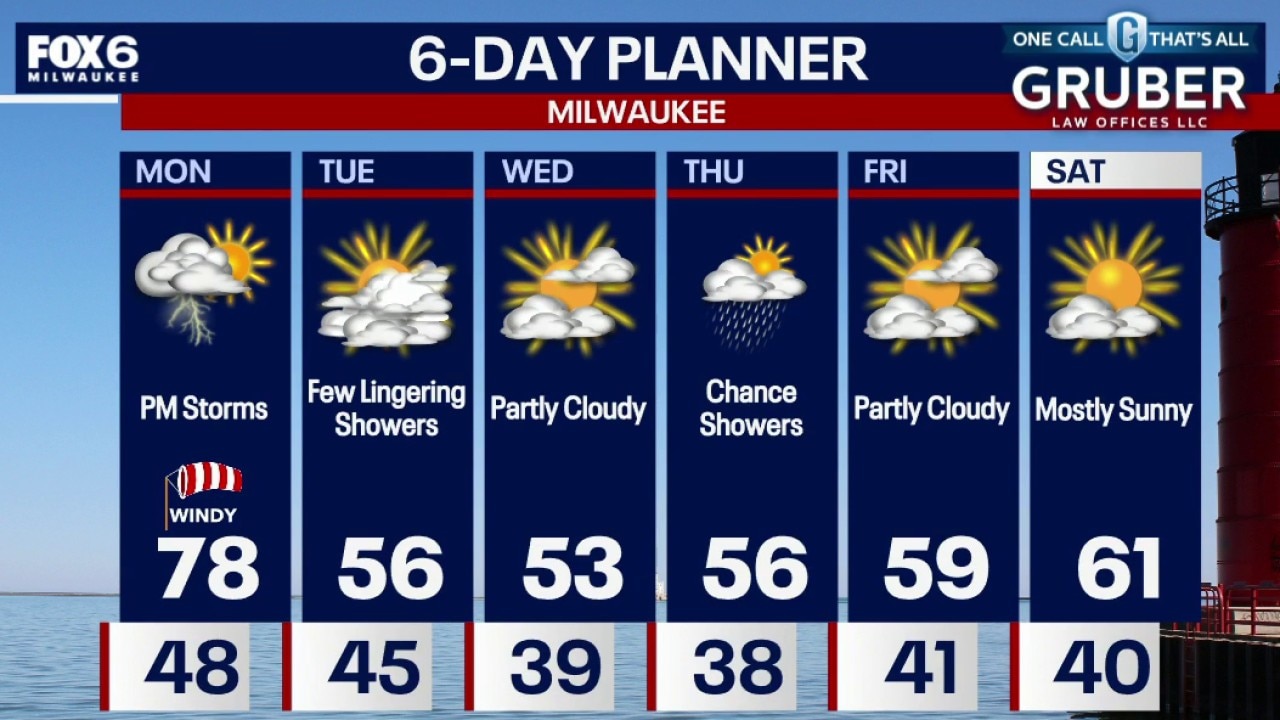
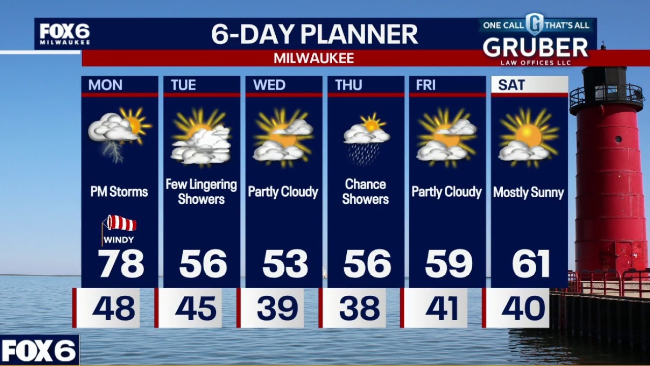
Windy again Monday and even warmer with temperatures in the mid 70s. Ahead of a cold front late Monday afternoon and evening, a few thunderstorms are possible. If a storm is stronger, hail and gusty winds are the main hazards.
Windy again Monday and even warmer with temperatures in the mid 70s. Ahead of a cold front late Monday afternoon and evening, a few thunderstorms are possible. If a storm is stronger, hail and gusty winds are the main hazards.
Weather webcast with Stephanie Barichello
Mostly sunny morning with temps in the 40s. Windy again Monday and even warmer with temperatures in the mid 70s. Ahead of a cold front late Monday afternoon and evening, a few thunderstorms are possible.
Mostly sunny morning with temps in the 40s. Windy again Monday and even warmer with temperatures in the mid 70s. Ahead of a cold front late Monday afternoon and evening, a few thunderstorms are possible.