

Snowfall totals from winter storm that impacted SE WI Dec. 29-30
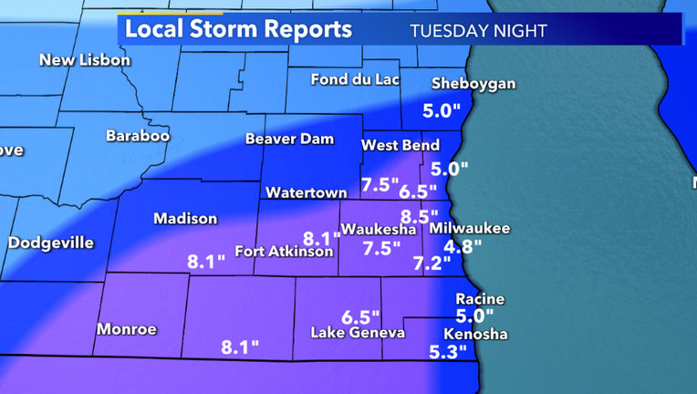
MILWAUKEE - The National Weather Service (NWS) collected data from the snowstorm that impacted southeast Wisconsin from Tuesday, Dec. 29 into Wednesday, Dec. 30.
Below is a list of the running snowfall totals (in inches) in southeast Wisconsin -- totals that could change.
CLICK HERE to view a snowfall totals map from the National Weather Service
- Brookfield, 8.5
- Sullivan, 8.1
- West Allis, 8.0
- Palmyra, 8.0
- Glendale, 7.5
- Merton, 7.5
- Waukesha, 7.5
- Hebron, 7.5
- Fox Point, 7.0
- Hartland, 7.0
- Pewaukee, 7.0
- Janesville, 6.8
- Lisbon, 6.8
- Mequon, 6.5
- Germantown, 6.5
- Cedarburg, 6.5
- Lake Geneva, 6.5
- Wauwatosa, 6.5
- West Allis, 6.5
- Oak Creek, 6.3
- Rochester, 6.0
- Dousman, 6.0
- Belgium, 6.0
- Plymouth, 6.0
- Elm Grove, 5.5
- Oconomowoc, 5.5
- Franklin, 5.5
- New Berlin, 5.3
- Twin Lakes, 5.3
- Delafield, 5.0
- Grafton, 5.0
- Watertown, 5.0
- Cedar Grove, 5.0
- Downtown Milwaukee, 5.0
- Milwaukee Mitchell International Airport, 4.8
- Twin Lakes, 4.7
- Johnson Creek, 4.7
- Big Bend, 4.5
- Wind Lake, 4.5
- Greendale, 4.2
- Pell Lake, 3.9
- Elkhorn, 3.8
- Theresa, 3.5
- Mount Calvary, 3.0
- Racine, 2.3
- Fond du Lac, 2.2
- Kenosha, 2.2
Featured

Winter weather welcomed by many in Walworth County
The Walworth County director of public works told FOX6 that 30 plow drivers will be working throughout the night, in addition to local and private plows.
Featured

Reminder: Milwaukee winter parking regulations in effect
The Milwaukee Department of Public Works reminds the public of winter parking regulations and potential parking regulations if a snow emergency is declared.