

Weather webcast with Lisa Michaels
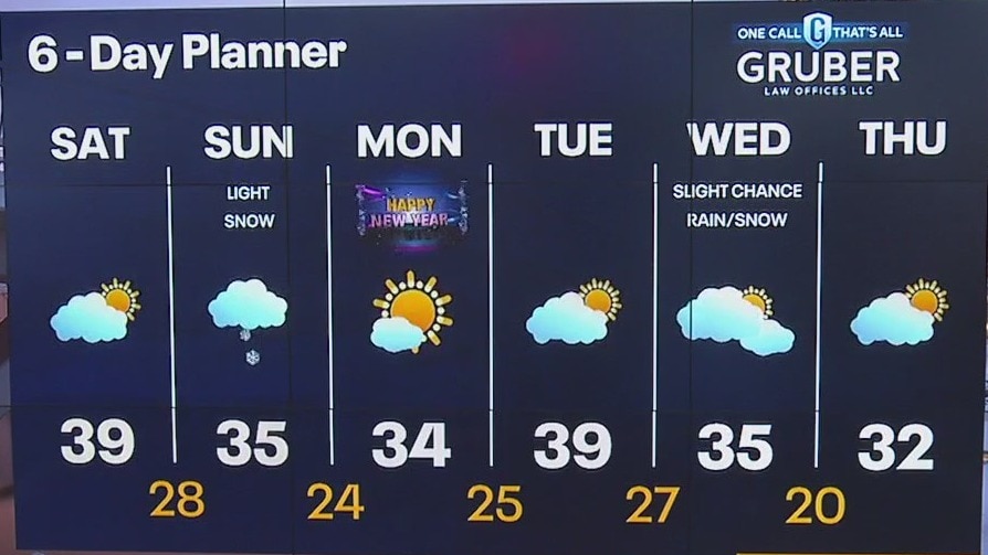
Patchy freezing fog and frigid temps Saturday morning. Starting off with sunshine and increasing cloud cover today. Highs in the upper 30s. Chances of snow enter the areas Sunday morning. Light accumulations possible. A cooler start to 2024 in the low to mid 30s.
Patchy freezing fog and frigid temps Saturday morning. Starting off with sunshine and increasing cloud cover today. Highs in the upper 30s. Chances of snow enter the areas Sunday morning. Light accumulations possible. A cooler start to 2024 in the low to mid 30s.
Weather Webcast with Meteorologist Eric Manges
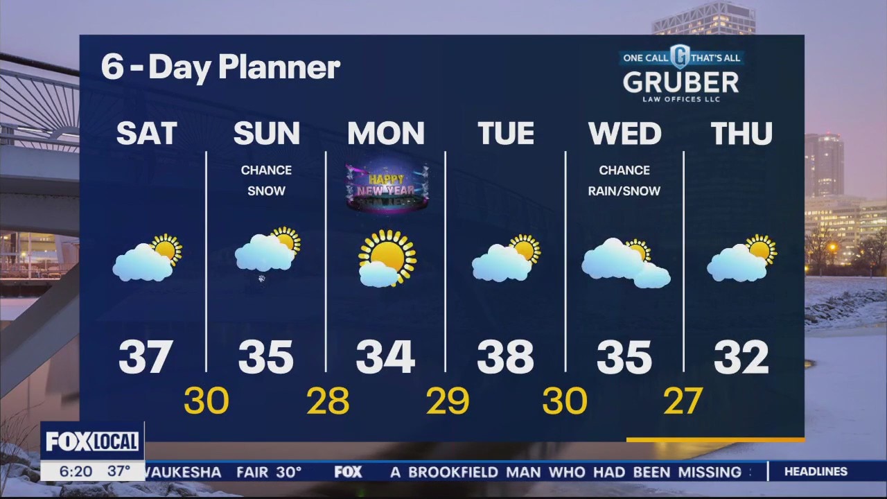
Chance of snow on Sunday as we end likely our warmest December on record
Chance of snow on Sunday as we end likely our warmest December on record

Future Forecaster: Meet 9-year-old Landon
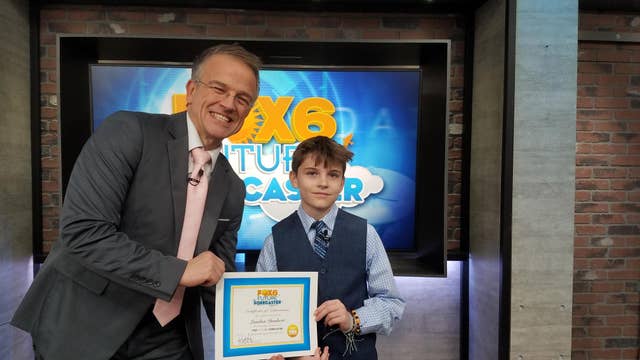
Meet 9-year-old Landon -- our latest Future Forecaster.
Meet 9-year-old Landon -- our latest Future Forecaster.
Weather webcast with Rob Haswell
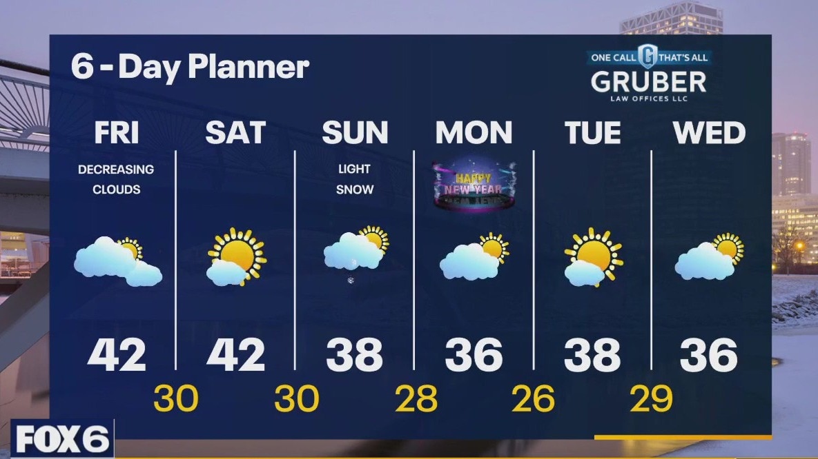
We slowly dry up and clear up today as an area of low pressure moves out of our region. Highs will again be in the upper 30s and low 40s. We should be dry and mostly sunny on Saturday with highs again in the low 40s. A disturbance arrives late Saturday into Sunday with a chance for light snow. We may see up to an inch is some spots.
We slowly dry up and clear up today as an area of low pressure moves out of our region. Highs will again be in the upper 30s and low 40s. We should be dry and mostly sunny on Saturday with highs again in the low 40s. A disturbance arrives late Saturday into Sunday with a chance for light snow. We may see up to an inch is some spots.
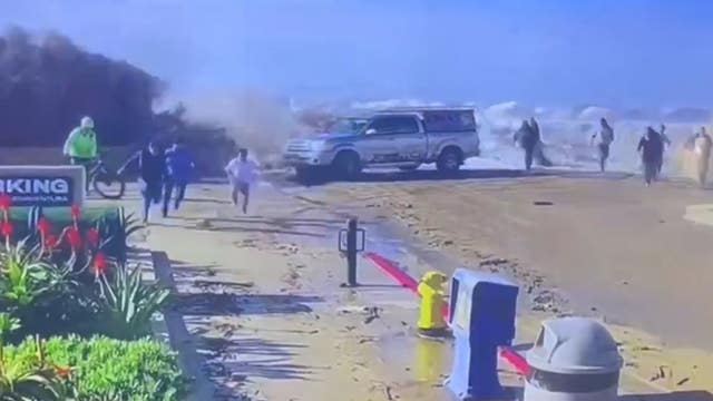

SoCal beaches experience dangerous waves, flooding as evacuations ordered
Forecasters say waves as high as 40 feet are possible Thursday in some locations along the California coast, with another round of swells set to arrive Saturday.
Forecasters say waves as high as 40 feet are possible Thursday in some locations along the California coast, with another round of swells set to arrive Saturday.
Weather Webcast with Stephanie Barichello
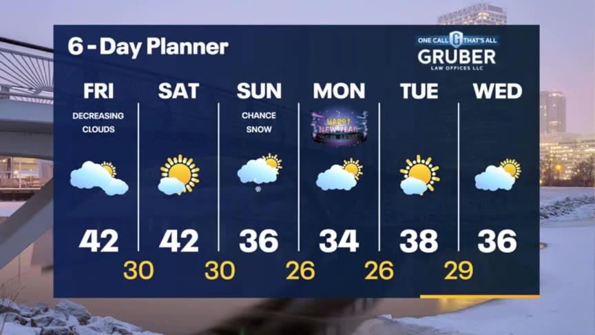
Rain and some wintry mix inland will come to an end tonight, then decreasing clouds on Friday. Chance for flurries or some light snow on New Year's Eve then chilly but dry on New Year's Day.
Rain and some wintry mix inland will come to an end tonight, then decreasing clouds on Friday. Chance for flurries or some light snow on New Year's Eve then chilly but dry on New Year's Day.
Weather webcast with Rob Haswell
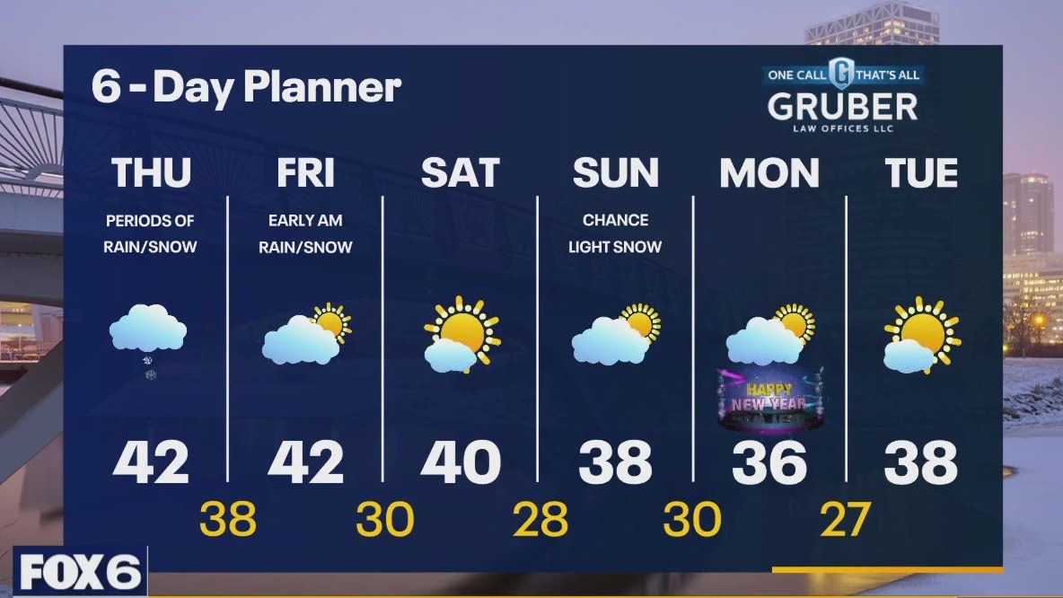
A wet morning with rain showers and snow showers across our area as a low retrogrades across the western lakes. As we warm this afternoon we'll change over to all rain but snow may mix back in as we cool this evening an overnight. After a few early showers on Friday morning we dry up and stay dry into Saturday with highs in the low 40s. We cool down early next week but remain above average for the season.
A wet morning with rain showers and snow showers across our area as a low retrogrades across the western lakes. As we warm this afternoon we'll change over to all rain but snow may mix back in as we cool this evening an overnight. After a few early showers on Friday morning we dry up and stay dry into Saturday with highs in the low 40s. We cool down early next week but remain above average for the season.

Weather Webcast with Meteorologist Eric Manges
Chance of rain and snow tomorrow then cooler heading into 2024
Chance of rain and snow tomorrow then cooler heading into 2024
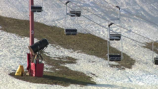

Challenging ski conditions in Wisconsin; region without natural snow
People who love to ski have found this winter to be exceptionally challenging. Wisconsin has yet to see a snow storm of any significance.
People who love to ski have found this winter to be exceptionally challenging. Wisconsin has yet to see a snow storm of any significance.
Weather webcast with Lisa Michaels
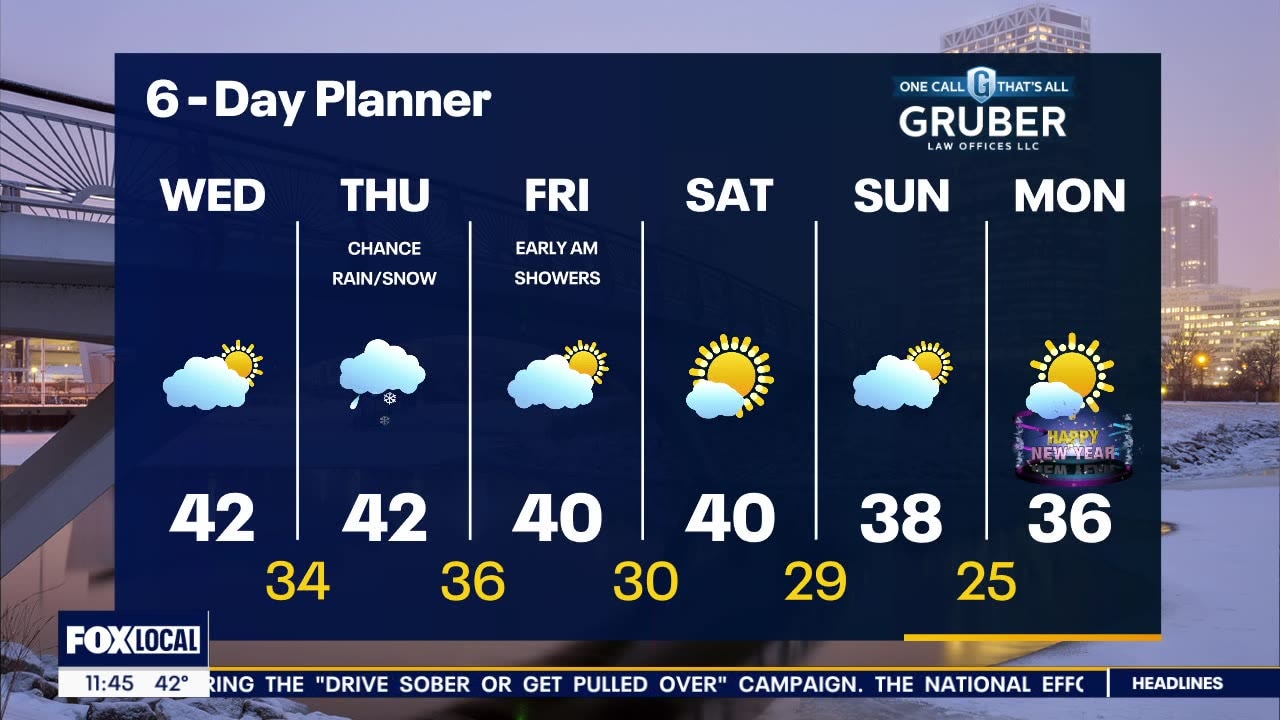
Clouds stay tonight bringing the chance of rain/snow early Thursday into Friday morning. Very minor accumulation possible inland with most areas not seeing any accumulation. Low visibility and slick spots in the early morning and night are possible. High temps remain in the upper 30s to lower 40s this week. Cooler air arrives by early next week welcoming in the new year, although we still remain above the seasonal averages.
Clouds stay tonight bringing the chance of rain/snow early Thursday into Friday morning. Very minor accumulation possible inland with most areas not seeing any accumulation. Low visibility and slick spots in the early morning and night are possible. High temps remain in the upper 30s to lower 40s this week. Cooler air arrives by early next week welcoming in the new year, although we still remain above the seasonal averages.

Weather webcast with Rob Haswell
A cooler start to our day today with partly cloudy conditions. Temperatures will still warm well above average with highs reaching the low 40s. An area of low pressure over the lower Great Lakes retrogrades into our area for Thursday with showers and a chance for some snow - mostly inland. Highs will warm into the low 40s again Thursday so any light accumulation early in the day will immediately melt. Cooler air arrives by early next although we still remain above the seasonal averages.
A cooler start to our day today with partly cloudy conditions. Temperatures will still warm well above average with highs reaching the low 40s. An area of low pressure over the lower Great Lakes retrogrades into our area for Thursday with showers and a chance for some snow - mostly inland. Highs will warm into the low 40s again Thursday so any light accumulation early in the day will immediately melt. Cooler air arrives by early next although we still remain above the seasonal averages.

Weather Webcast with Meteorologist Eric Manges
Chance of rain and snow on Thursday then cooler air to end the year
Chance of rain and snow on Thursday then cooler air to end the year
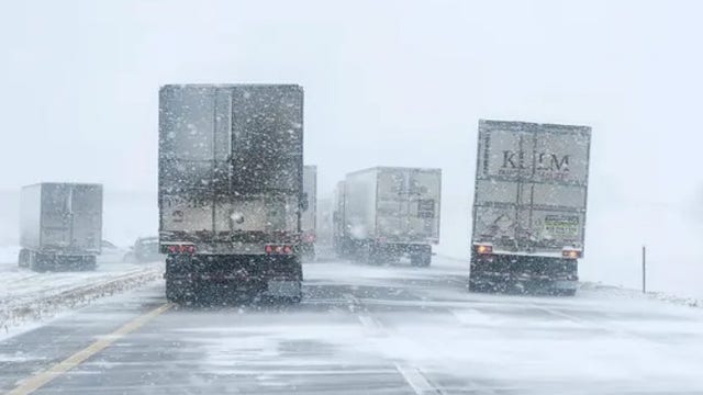

Deadly blizzard, ice storm snarls post-Christmas travel across central US
The storm claimed a life in Kansas when an elderly woman died in a crash along a snowy state highway on Christmas evening.
The storm claimed a life in Kansas when an elderly woman died in a crash along a snowy state highway on Christmas evening.
Weather webcast with Lisa Michaels
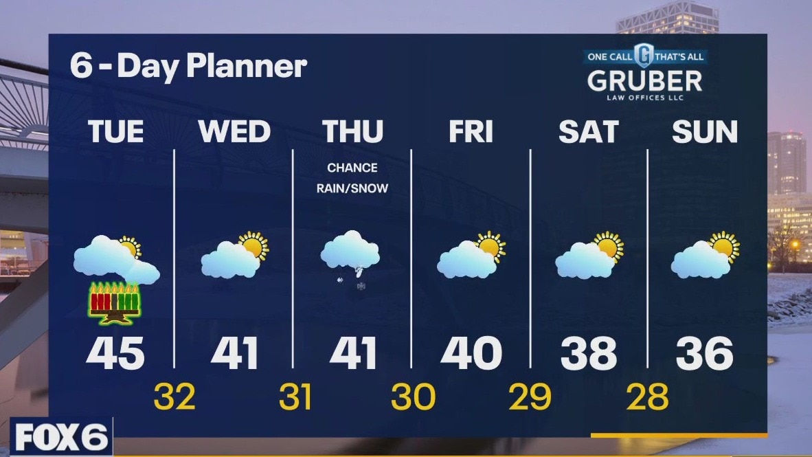
Patchy fog and drizzle. Mostly cloudy and mild in the 40s during the morning. Temperatures slowly drop into the upper 30s to low 40s for highs under mostly cloudy skies. Next chance of rain/snow could clip us on Thursday. More seasonable temps end the month and welcome the new year.
Patchy fog and drizzle. Mostly cloudy and mild in the 40s during the morning. Temperatures slowly drop into the upper 30s to low 40s for highs under mostly cloudy skies. Next chance of rain/snow could clip us on Thursday. More seasonable temps end the month and welcome the new year.

Weather Webcast with Meteorologist Eric Manges
Rain ending tonight then cooler air moving in tomorrow
Rain ending tonight then cooler air moving in tomorrow
Weather webcast with Lisa Michaels
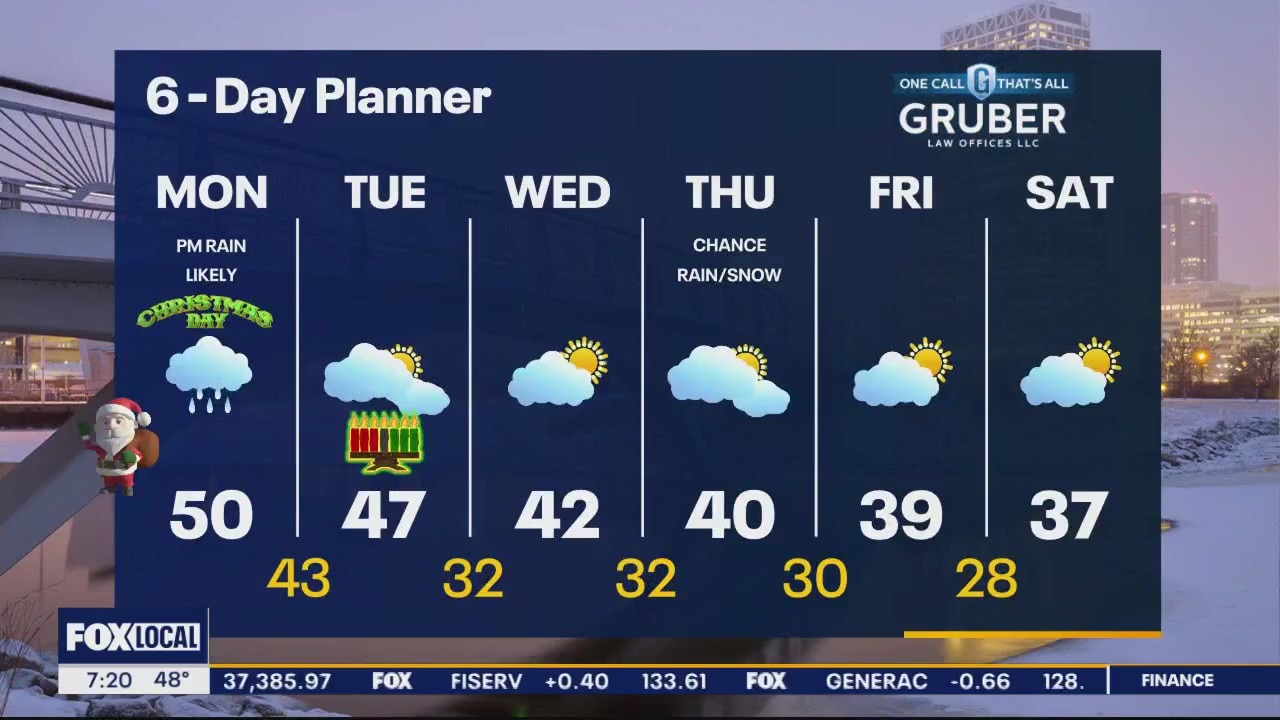
Patchy fog and cloudy in the morning. Mild temps in the upper 40s to low 50s. Cloudy Christmas Day with rain starting mostly in the afternoon then rain potential continues through Tuesday morning.
Patchy fog and cloudy in the morning. Mild temps in the upper 40s to low 50s. Cloudy Christmas Day with rain starting mostly in the afternoon then rain potential continues through Tuesday morning.

Weather Webcast with Meteorologist Eric Manges
Staying warm and rainy Christmas Day then cooling temperatures to end the week
Staying warm and rainy Christmas Day then cooling temperatures to end the week


Slight earthquakes shake Big Island in Hawaii and Puget Sound region, no damage reported
Hundreds of people reported feeling minor earthquakes of similar intensity on Hawaii's Big Island and on the Olympic Peninsula northwest of Seattle, but no damage was reported.
Hundreds of people reported feeling minor earthquakes of similar intensity on Hawaii's Big Island and on the Olympic Peninsula northwest of Seattle, but no damage was reported.
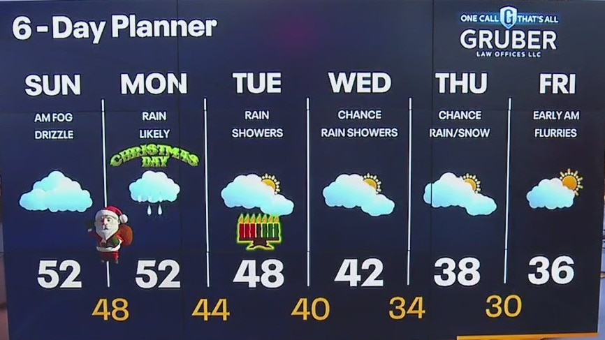
Weather webcast with Rob Haswell
Dense fog advisory until 9 a.m., take care on area roads. Very mild today with highs in the low 50s likely. Patchy drizzle a times. A low arrives overnight with rain arriving for Christmas Day. Most areas will see around 0.5" Cold air and a chance for some light snow arrives late next week.
Dense fog advisory until 9 a.m., take care on area roads. Very mild today with highs in the low 50s likely. Patchy drizzle a times. A low arrives overnight with rain arriving for Christmas Day. Most areas will see around 0.5" Cold air and a chance for some light snow arrives late next week.
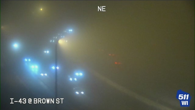

Dense fog advisory, Sunday morning travel could be impacted
The National Weather Service issued a dense fog advisory for parts of southeast Wisconsin – effective through 9 a.m. Sunday, Dec. 24.
The National Weather Service issued a dense fog advisory for parts of southeast Wisconsin – effective through 9 a.m. Sunday, Dec. 24.