

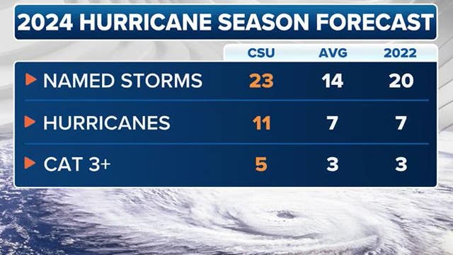

2024 Atlantic hurricane season could be among most active on record, experts predict
Colorado State University hurricane researchers have released their initial outlook for the upcoming Atlantic hurricane season, which they believe promises to be an extremely active year, courtesy of an impending La Niña.
Colorado State University hurricane researchers have released their initial outlook for the upcoming Atlantic hurricane season, which they believe promises to be an extremely active year, courtesy of an impending La Niña.

Weather webcast with Lisa Michaels
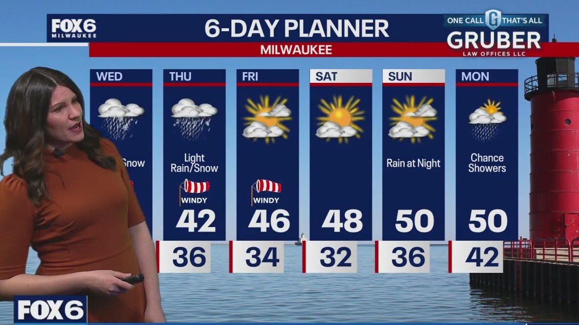
Last of the rain/snow mix will be today. High temperatures reach the low 40s this afternoon with breezy winds gusting near 30mph. (.5"-1") Clouds start to clear by Friday with highs in the low to mid 40s. Gradual warming temps into the 50s by Sunday. The weekend looks mainly dry Rain will enter back into the forecast late Sunday and into early Monday.
Last of the rain/snow mix will be today. High temperatures reach the low 40s this afternoon with breezy winds gusting near 30mph. (.5"-1") Clouds start to clear by Friday with highs in the low to mid 40s. Gradual warming temps into the 50s by Sunday. The weekend looks mainly dry Rain will enter back into the forecast late Sunday and into early Monday.
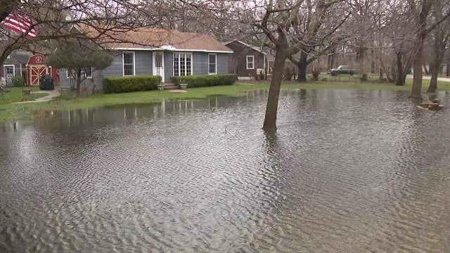

Kenosha County storm flooding makes impact on area
Some areas are seeing the water rise around them after recent rain, which included snow in certain areas. That includes Kenosha County, along the Fox River.
Some areas are seeing the water rise around them after recent rain, which included snow in certain areas. That includes Kenosha County, along the Fox River.
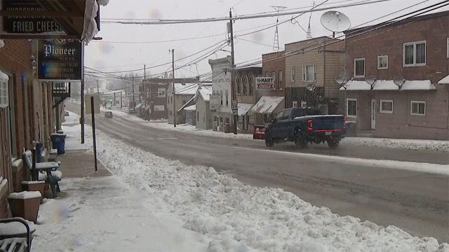

Wisconsin snow: Dodge County power outages reported
A spring snowfall blanketed parts of Dodge County from Tuesday night into Wednesday. The heavy snow left some residents without power.
A spring snowfall blanketed parts of Dodge County from Tuesday night into Wednesday. The heavy snow left some residents without power.
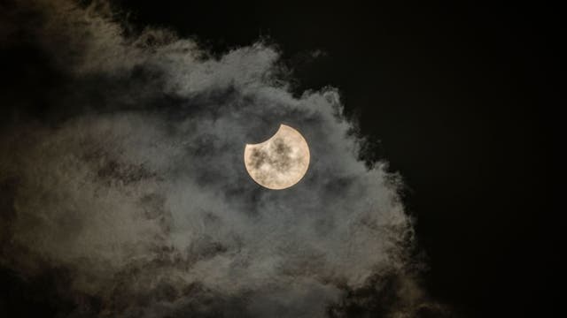

What happens if it's cloudy during the eclipse? The answer depends, researchers say
As the total lunar eclipse on April 8 approaches, one study suggests that cloudy forecasts may not spoil the celestial event.
As the total lunar eclipse on April 8 approaches, one study suggests that cloudy forecasts may not spoil the celestial event.


Snowfall totals: Wisconsin spring storm April 2-3, 2024
The National Weather Service (NWS) is collecting snowfall data from the spring storm that impacted southeastern Wisconsin on Tuesday, April 2 into Wednesday, April 3.
The National Weather Service (NWS) is collecting snowfall data from the spring storm that impacted southeastern Wisconsin on Tuesday, April 2 into Wednesday, April 3.
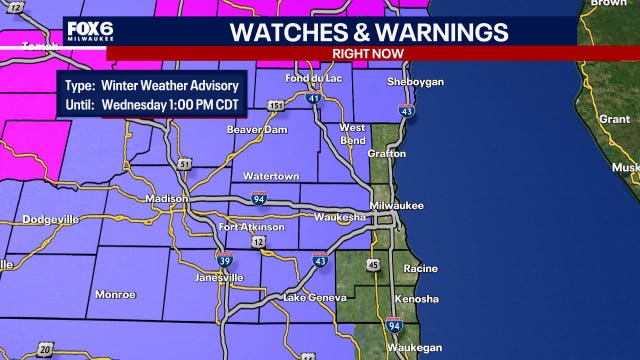

Southeast Wisconsin winter weather advisory in effect until 1 p.m.
A winter weather advisory is in effect for parts of southeast Wisconsin until 1 p.m. Wednesday, April 3.
A winter weather advisory is in effect for parts of southeast Wisconsin until 1 p.m. Wednesday, April 3.


Taiwan earthquake: Strongest in nearly 25 years leaves 9 dead
A 7.4-magnitude earthquake struck Taiwan, damaging buildings and leaving several dead. Here’s what’s known about the massive quake.
A 7.4-magnitude earthquake struck Taiwan, damaging buildings and leaving several dead. Here’s what’s known about the massive quake.

Weather webcast with Rob Haswell
As the storm low lingers over Michigan, we are on its Western side dealing with periods of wet snow and rain. Winter Weather Advisories continue for all inland and northern counties today with another 2-4" of wet snow possible. More rain and snow showers Thursday before we dry up on Friday and into the weekend. Highs today will be near 40 and stay in the 40s tomorrow and Friday but warm into the 50s for the weekend and early next week.
As the storm low lingers over Michigan, we are on its Western side dealing with periods of wet snow and rain. Winter Weather Advisories continue for all inland and northern counties today with another 2-4" of wet snow possible. More rain and snow showers Thursday before we dry up on Friday and into the weekend. Highs today will be near 40 and stay in the 40s tomorrow and Friday but warm into the 50s for the weekend and early next week.
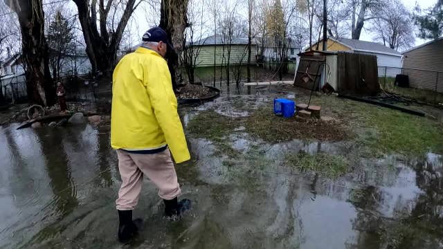

Milwaukee couple battles backyard flooding
An elderly Milwaukee couple said they’re in need of help as floodwaters take over their backyard.
An elderly Milwaukee couple said they’re in need of help as floodwaters take over their backyard.
Weather webcast with Stephanie Barichello
Windy and messy this evening with rain changing to snow from west to east this evening, although the southern lakeshore may stay mainly rain.
Windy and messy this evening with rain changing to snow from west to east this evening, although the southern lakeshore may stay mainly rain.
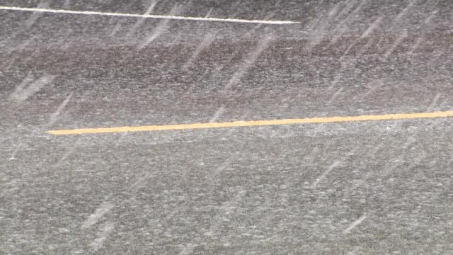

West Bend winter weather; gearing up before snow hits
In Washington County, heavy rain drenched West Bend on Tuesday, April 1.
In Washington County, heavy rain drenched West Bend on Tuesday, April 1.
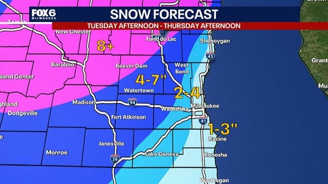

Spring snow in southeast WI; Election day, Brewers home opener impacted
While many may have thought it was a weather-related April Fool's joke, the potential for snow on Tuesday, April 2 – election day and the Brewer's home opener – is no joke.
While many may have thought it was a weather-related April Fool's joke, the potential for snow on Tuesday, April 2 – election day and the Brewer's home opener – is no joke.
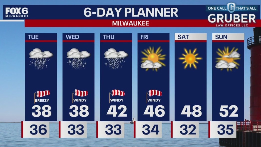
Weather webcast with Chief Meteorologist Rob Haswell
A low passes from Missouri into Michigan today where it stalls for several hours, sending us bands of rain and snow. A Winter Weather Advisory goes into effect for Washington, Dodge, Sheboygan and Jefferson counties at 4pm and lasts through 10pm. A few inches of wet snow is expected with the lowest amounts in the far southeast counties and lakeside. Heaviest accumulations will be in our northwest counties. Snow will taper off through the early part of Thursday and the sun and warmer conditions return late week and into the weekend.
A low passes from Missouri into Michigan today where it stalls for several hours, sending us bands of rain and snow. A Winter Weather Advisory goes into effect for Washington, Dodge, Sheboygan and Jefferson counties at 4pm and lasts through 10pm. A few inches of wet snow is expected with the lowest amounts in the far southeast counties and lakeside. Heaviest accumulations will be in our northwest counties. Snow will taper off through the early part of Thursday and the sun and warmer conditions return late week and into the weekend.
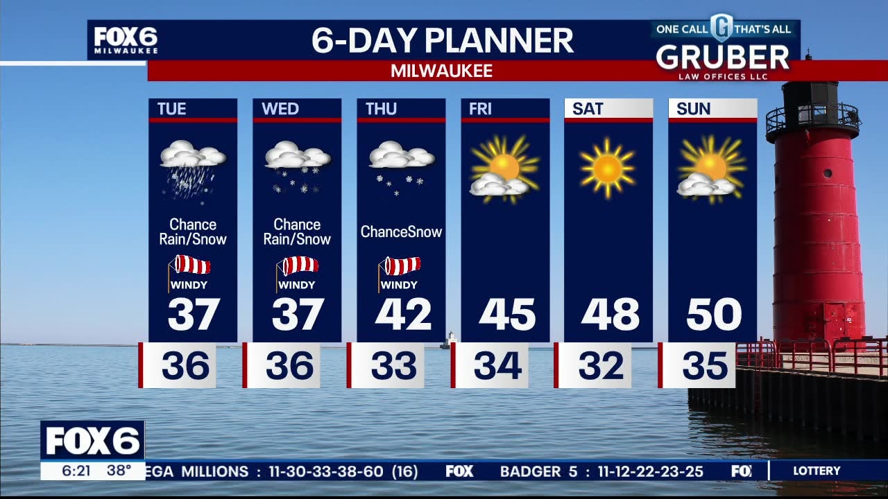
Weather webcast with Lisa Michaels
A parade of low pressure systems passes to our south in the next couple of days. A wintry mix tonight with the chance of rain and snow through Thursday. A slushy accumulation is possible. Fond du Lac and Sheboygan counties could see higher amounts. Temperatures will max out in the upper 30s and low 40s through Thursday and then warm into the 50s by the weekend.
A parade of low pressure systems passes to our south in the next couple of days. A wintry mix tonight with the chance of rain and snow through Thursday. A slushy accumulation is possible. Fond du Lac and Sheboygan counties could see higher amounts. Temperatures will max out in the upper 30s and low 40s through Thursday and then warm into the 50s by the weekend.
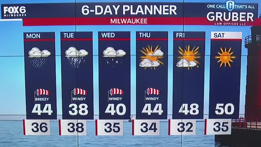
Weather webcast with Chief Meteorologist Rob Haswell
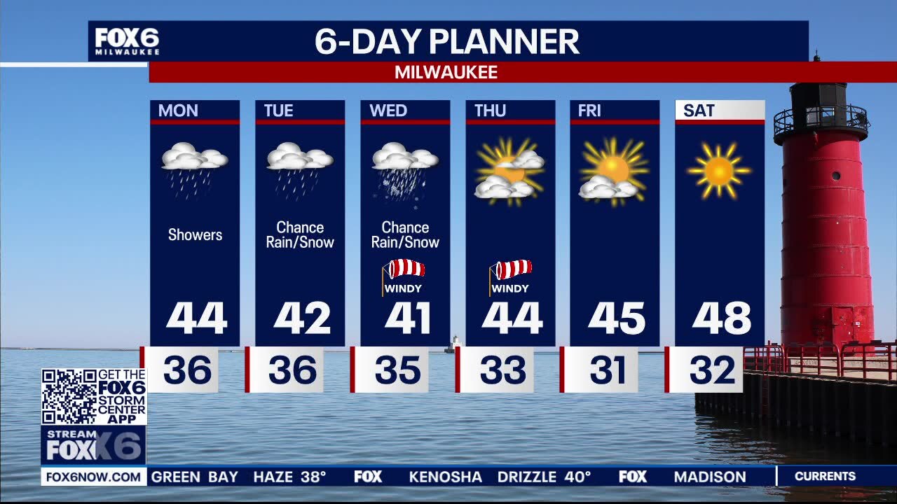
A series of low pressure systems pass to our south bringing rain tonight into Monday. Rain and snow chances in the forecast Tuesday through Wednesday. Potential snow accumulation. Temps will remain in the low to mid 40s this week. Sunshine and warmer temps return near the end of next week.
A series of low pressure systems pass to our south bringing rain tonight into Monday. Rain and snow chances in the forecast Tuesday through Wednesday. Potential snow accumulation. Temps will remain in the low to mid 40s this week. Sunshine and warmer temps return near the end of next week.
Weather webcast with Lisa Michaels
A series of low pressure systems pass to our south bringing rain tonight into Monday. Rain and snow chances in the forecast Tuesday through Wednesday. Potential snow accumulation. Temps will remain in the low to mid 40s this week. Sunshine and warmer temps return near the end of next week.
A series of low pressure systems pass to our south bringing rain tonight into Monday. Rain and snow chances in the forecast Tuesday through Wednesday. Potential snow accumulation. Temps will remain in the low to mid 40s this week. Sunshine and warmer temps return near the end of next week.

Weather webcast with Chief Meteorologist Rob Haswell
A series of low pressure systems pass to our south today, Easter Sunday, tonight and tomorrow with several rounds of rain likely. Rain arrives later today and continues through tonight into Monday. Rain, possibly mixed with snow, continues on Tuesday and Wednesday before we dry up. Temperatures will be below average today and through the late week with highs in the low to mid 40s. A warm up begins Friday and continues into the weekend!
A series of low pressure systems pass to our south today, Easter Sunday, tonight and tomorrow with several rounds of rain likely. Rain arrives later today and continues through tonight into Monday. Rain, possibly mixed with snow, continues on Tuesday and Wednesday before we dry up. Temperatures will be below average today and through the late week with highs in the low to mid 40s. A warm up begins Friday and continues into the weekend!


Weather webcast with Chief Meteorologist Rob Haswell
A series of low pressure systems pass to our south today, tonight and tomorrow with several rounds of rain likely. Rain arrives later today and continues through tonight into Monday. Rain, possibly mixed with snow, continues on Tuesday and Wednesday before we dry up. Temperatures will be below average today and through the late week with highs in the low to mid 40s. A warm up begins Friday and continues into the weekend!
A series of low pressure systems pass to our south today, tonight and tomorrow with several rounds of rain likely. Rain arrives later today and continues through tonight into Monday. Rain, possibly mixed with snow, continues on Tuesday and Wednesday before we dry up. Temperatures will be below average today and through the late week with highs in the low to mid 40s. A warm up begins Friday and continues into the weekend!
Weather webcast with Lisa Michaels
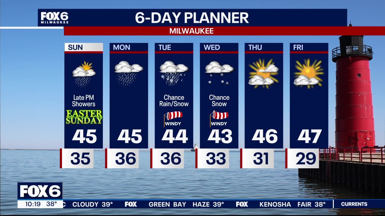
High pressure keeps weather calm tonight into the start of Easter Sunday. Lows drop into the mid 30s. Isolated light fog is possible. Dry but mostly cloudy on Easter Sunday. Isolated shower Sunday afternoon but more rain by Sunday night. Rain continues through Monday. Chances of rain/snow possible Tuesday with better chances of snow into Wednesday. Still too soon for potential accumulation amounts. Temps remain in the low to mid 40s.
High pressure keeps weather calm tonight into the start of Easter Sunday. Lows drop into the mid 30s. Isolated light fog is possible. Dry but mostly cloudy on Easter Sunday. Isolated shower Sunday afternoon but more rain by Sunday night. Rain continues through Monday. Chances of rain/snow possible Tuesday with better chances of snow into Wednesday. Still too soon for potential accumulation amounts. Temps remain in the low to mid 40s.