

Weather webcast with Lisa Michaels
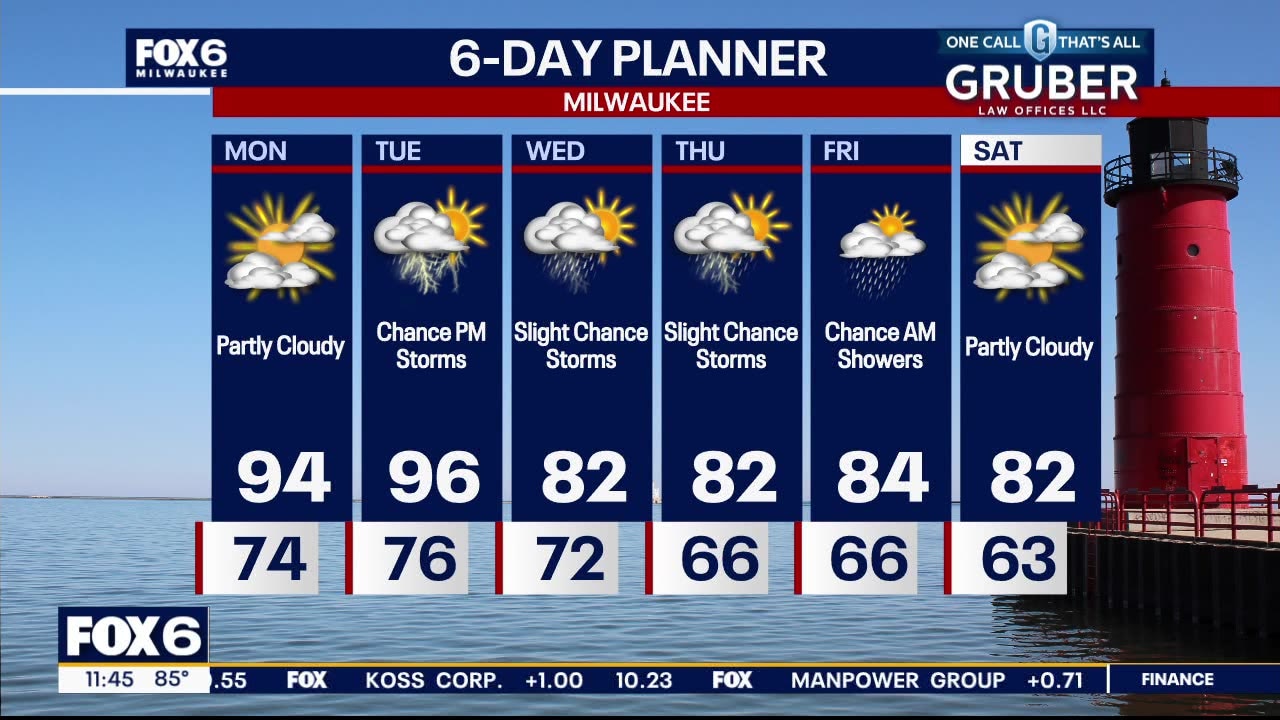
Very hot and humid for the next few days. Heat Advisories along with Excessive Heat Warnings and Watches are in place. Highs today will reach the low to mid 90s but with dew point readings in the 70s, it will feel more like 100 or higher. We remain hot through Tuesday but should return to near average temperatures mid to late week. There is a risk for thunderstorms tonight and Tuesday. Some of those storms could be severe.
Very hot and humid for the next few days. Heat Advisories along with Excessive Heat Warnings and Watches are in place. Highs today will reach the low to mid 90s but with dew point readings in the 70s, it will feel more like 100 or higher. We remain hot through Tuesday but should return to near average temperatures mid to late week. There is a risk for thunderstorms tonight and Tuesday. Some of those storms could be severe.


Southeast WI extreme heat; Milwaukee Health Department issues alert
The City of Milwaukee Health Department and Milwaukee County Office of Emergency Management issued on Monday, Aug. 26 an alert for a Heat Health Advisory and Watch.
The City of Milwaukee Health Department and Milwaukee County Office of Emergency Management issued on Monday, Aug. 26 an alert for a Heat Health Advisory and Watch.


When is the first day of fall 2024? What to know about the autumnal season
With pumpkin spice on the menu, it may seem like fall is just around the corner.
With pumpkin spice on the menu, it may seem like fall is just around the corner.
Weather webcast with Rob Haswell
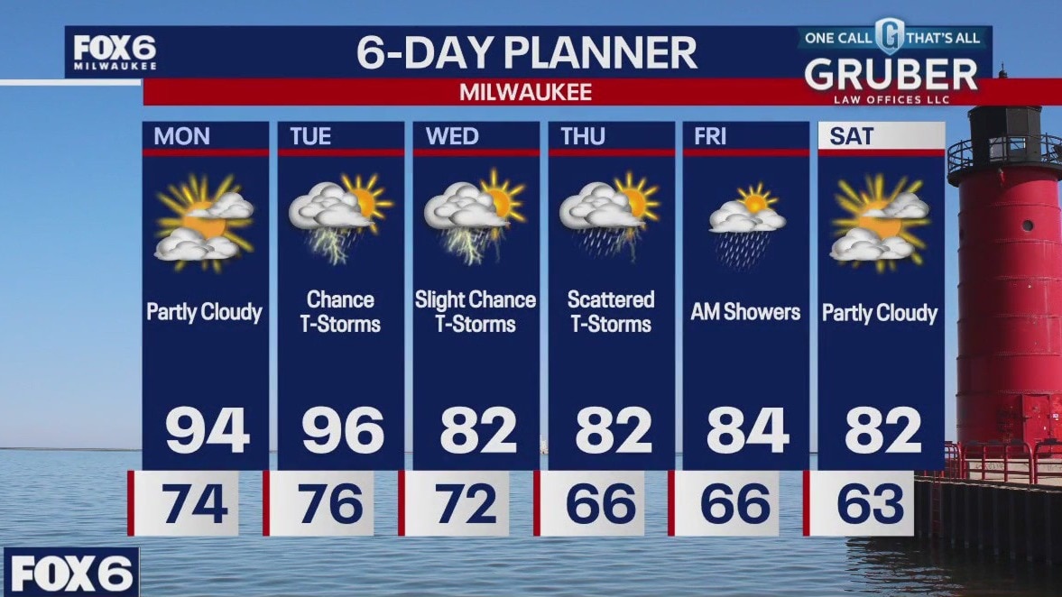
Very hot and humid for the next few days. Heat Advisories along with Excessive Heat Warnings and Watches are in place. Highs today will reach the low to mid 90s but with dew point readings in the 70s, it will feel more like 100 or higher. We remain hot through Tuesday but should return to near average temperatures mid to late week. There is a risk for thunderstorms tonight and Tuesday. Some of those storms could be severe.
Very hot and humid for the next few days. Heat Advisories along with Excessive Heat Warnings and Watches are in place. Highs today will reach the low to mid 90s but with dew point readings in the 70s, it will feel more like 100 or higher. We remain hot through Tuesday but should return to near average temperatures mid to late week. There is a risk for thunderstorms tonight and Tuesday. Some of those storms could be severe.
Weather Webcast with Chief Meteorologist Tom Wachs
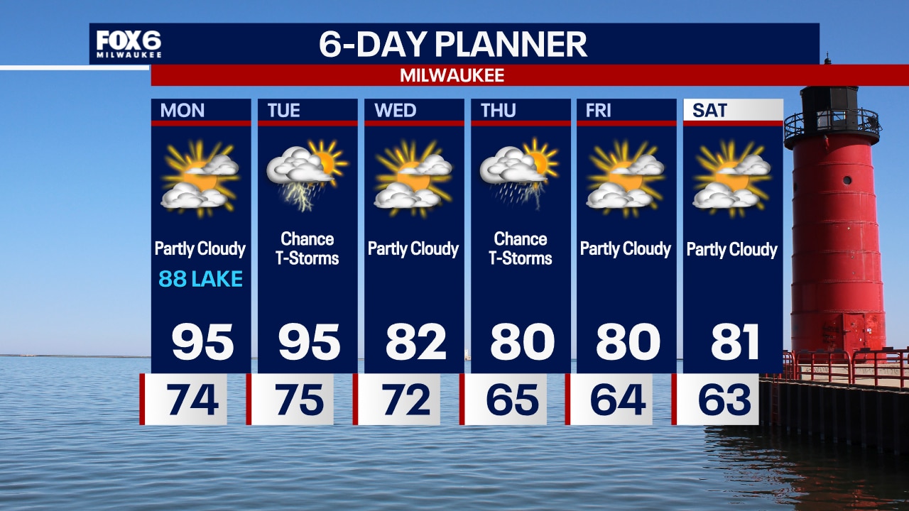
Hot and humid on Monday and Tuesday. Highs in the 90s with a heat index over 100...especially away from the lake. T-Storms are possible on Tuesday.
Hot and humid on Monday and Tuesday. Highs in the 90s with a heat index over 100...especially away from the lake. T-Storms are possible on Tuesday.


Watch: Six Flags Mexico riders stranded midair during storm, caught in heavy rain
On August 18, riders at Six Flags Mexico were left dangling mid-air after a storm caused the Sky Screamer ride to stall.
On August 18, riders at Six Flags Mexico were left dangling mid-air after a storm caused the Sky Screamer ride to stall.
Weather Webcast with Chief Meteorologist Tom Wachs
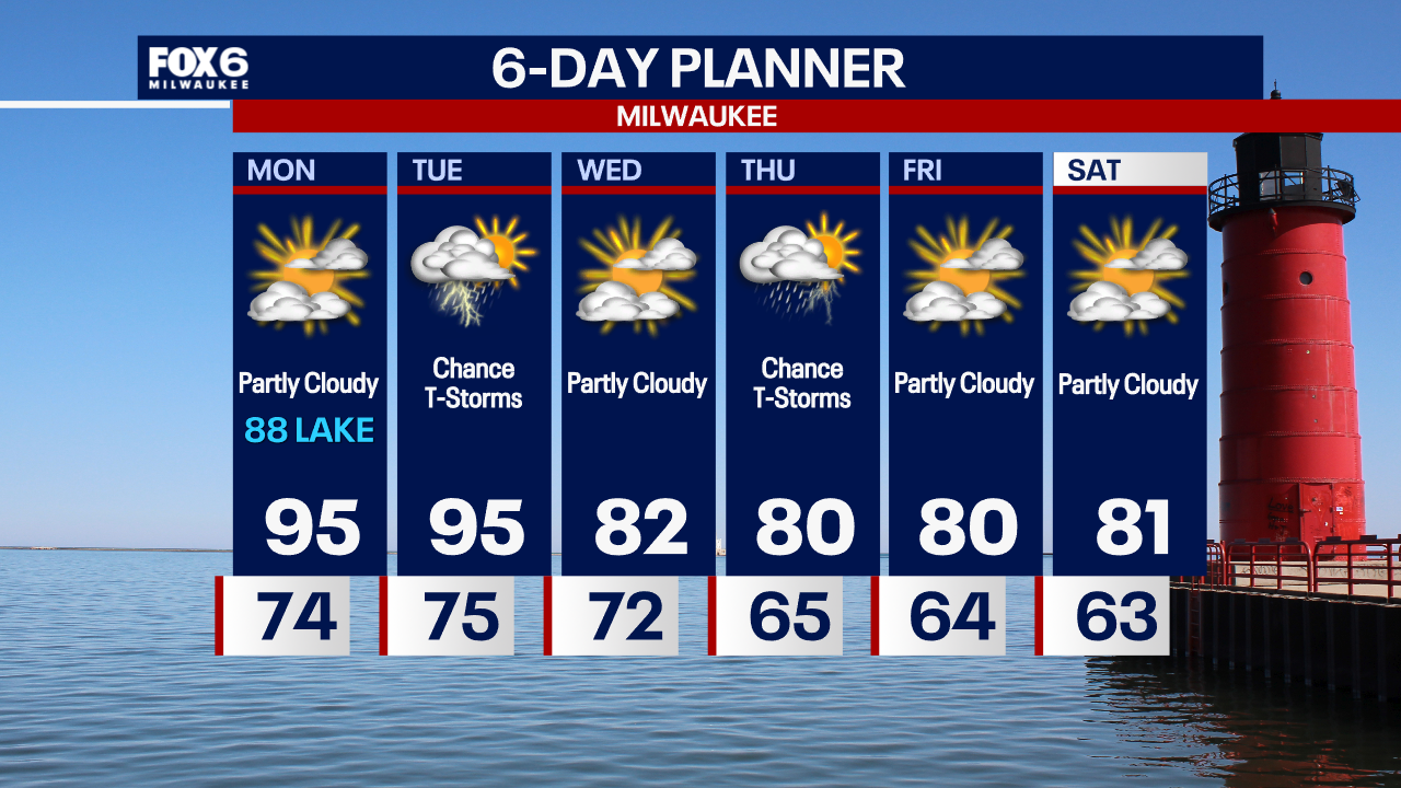
Hot and humid Monday and Tuesday. Cooling down on Wednesday. T-Storms are possible on Tuesday, some could be strong to severe.
Hot and humid Monday and Tuesday. Cooling down on Wednesday. T-Storms are possible on Tuesday, some could be strong to severe.


Southeast WI extreme heat; some schools postpone 1st day of class
The extreme heat forecast for southeast Wisconsin is forcing some schools to change the start date of the school year.
The extreme heat forecast for southeast Wisconsin is forcing some schools to change the start date of the school year.


Hurricane Hone: Hawaii blasted with flooding rain, damaging wind; thousands without power
Hawaii's Big Island has seen round after round of squally weather that has knocked out power to thousands of residents and prompted Flash Flood Warnings.
Hawaii's Big Island has seen round after round of squally weather that has knocked out power to thousands of residents and prompted Flash Flood Warnings.
Weather webcast with Stephanie Barichello
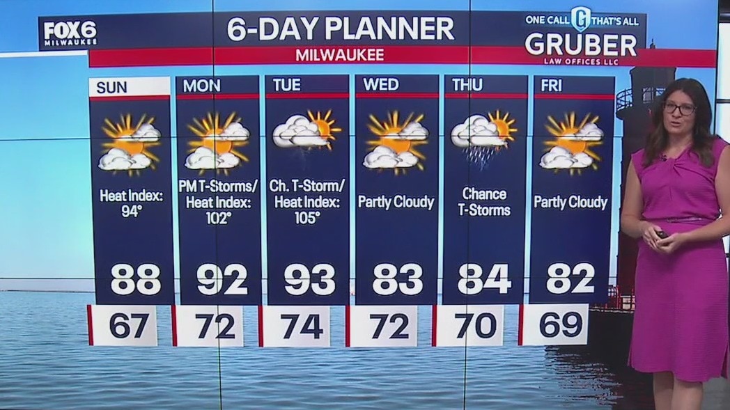
A mix of clouds and sun today with a slight chance for a passing shower. It'll be a warmer and humid day with highs in the mid to upper 80s and feel like temperatures in the 90s. Dangerous heat and humidity ahead on Monday and Tuesday.
A mix of clouds and sun today with a slight chance for a passing shower. It'll be a warmer and humid day with highs in the mid to upper 80s and feel like temperatures in the 90s. Dangerous heat and humidity ahead on Monday and Tuesday.
Weather webcast with Lisa Michaels
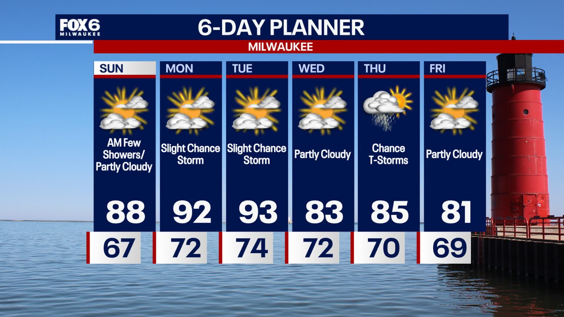
Partly cloudy skies Saturday night with temps in the upper 60s. A few showers are possible into Sunday morning, otherwise another partly sunny, humid and warm day ahead. Highs Sunday in the upper 80s with dew points near 70?F. Hot and humid early next week, with possible feel like temperatures approaching 100?F in spots inland on Monday. Tuesday has the better chance for more areas to experience higher heat index values. A front rolls through on Wednesday which will drop temps back into the lower 80s.
Partly cloudy skies Saturday night with temps in the upper 60s. A few showers are possible into Sunday morning, otherwise another partly sunny, humid and warm day ahead. Highs Sunday in the upper 80s with dew points near 70?F. Hot and humid early next week, with possible feel like temperatures approaching 100?F in spots inland on Monday. Tuesday has the better chance for more areas to experience higher heat index values. A front rolls through on Wednesday which will drop temps back into the lower 80s.

Weather webcast with Stephanie Barichello
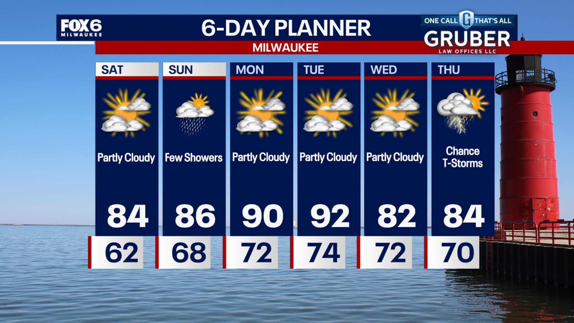
A mix of clouds and sun today with humid conditions and temperatures in the low 80s. We'll drop a little bit lakeside in the afternoon thanks to a lake breeze. A few showers possible overnight and throughout Sunday.
A mix of clouds and sun today with humid conditions and temperatures in the low 80s. We'll drop a little bit lakeside in the afternoon thanks to a lake breeze. A few showers possible overnight and throughout Sunday.
Weather Webcast with Stephanie Barichello
Pleasant this evening, then more summer like over the weekend. There is a low chance for showers on Sunday. Hot and humid early next week.
Pleasant this evening, then more summer like over the weekend. There is a low chance for showers on Sunday. Hot and humid early next week.


Future Forecaster: Meet 12-year-old Brinnly
Meet 12-year-old Brinnly -- our latest Future Forecaster.
Meet 12-year-old Brinnly -- our latest Future Forecaster.

Future Forecaster: Meet 12-year-old Brinnly
She wanted to be a Future Forecaster -- and that's exactly what FOX6 WakeUp News is helping her?accomplish.
She wanted to be a Future Forecaster -- and that's exactly what FOX6 WakeUp News is helping her?accomplish.
Weather webcast with Rob Haswell
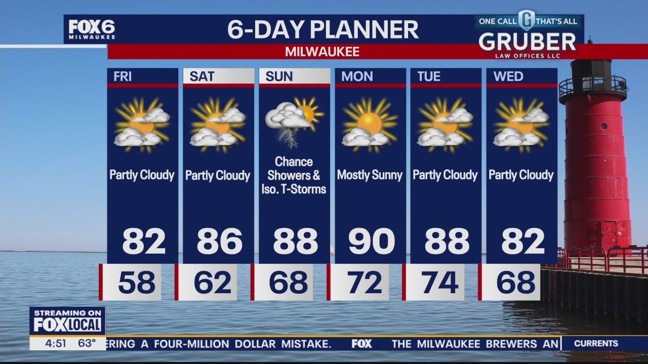
High pressure slowly inches to the east of our area over the next couple of days encouraging a warmer, more southerly flow of air. Temperatures and dew points will surge through the weekend into early next week. We remain rain-free today and Saturday but there is a chance of showers and thunderstorms on Sunday, mostly in the morning hours. We should return to average conditions later next week.
High pressure slowly inches to the east of our area over the next couple of days encouraging a warmer, more southerly flow of air. Temperatures and dew points will surge through the weekend into early next week. We remain rain-free today and Saturday but there is a chance of showers and thunderstorms on Sunday, mostly in the morning hours. We should return to average conditions later next week.
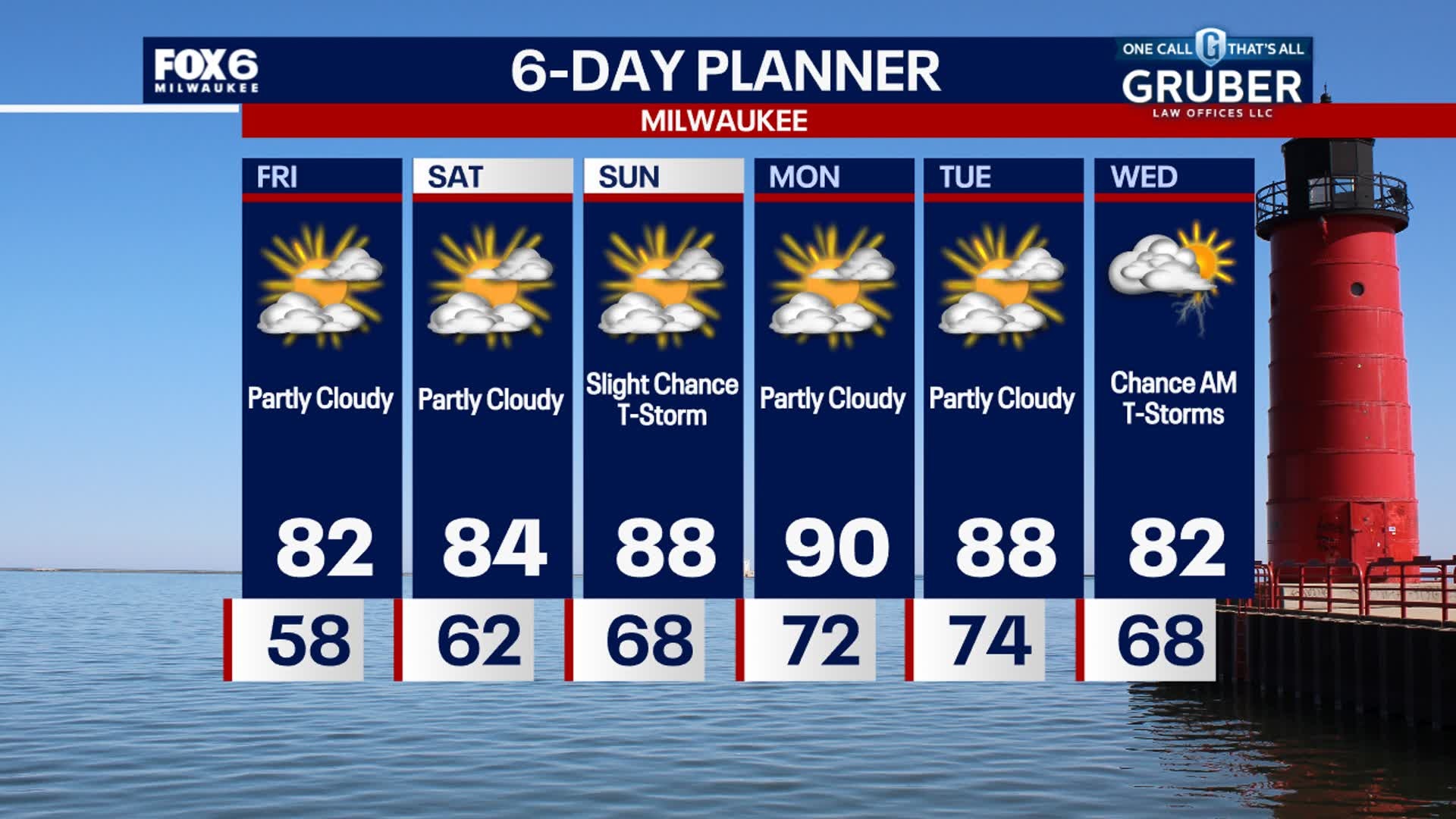
Weather Webcast with Stephanie Barichello
Heating up in the coming days with slight chances for showers and storms, especially on Sunday.
Heating up in the coming days with slight chances for showers and storms, especially on Sunday.
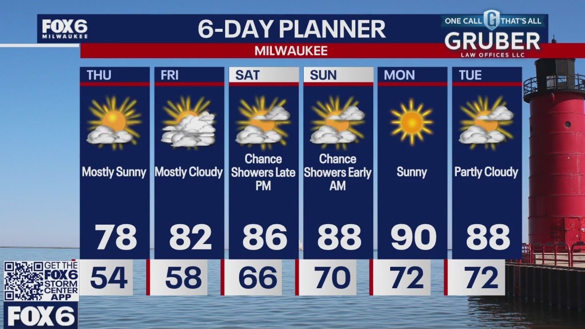
Weather webcast with Rob Haswell
Another day with a strong ridge of high pressure in charge of our forecast. Ample sunshine and warming today with highs in the mid to upper 70s. We warm into the low 80s Friday and then start a stretch of hot weather as high temperatures reach the upper 80s to near 90 from Saturday through the middle of next week. We stay dry today and have only a slight chance of showers and isolated thunderstorms late Saturday night into early Sunday morning.
Another day with a strong ridge of high pressure in charge of our forecast. Ample sunshine and warming today with highs in the mid to upper 70s. We warm into the low 80s Friday and then start a stretch of hot weather as high temperatures reach the upper 80s to near 90 from Saturday through the middle of next week. We stay dry today and have only a slight chance of showers and isolated thunderstorms late Saturday night into early Sunday morning.
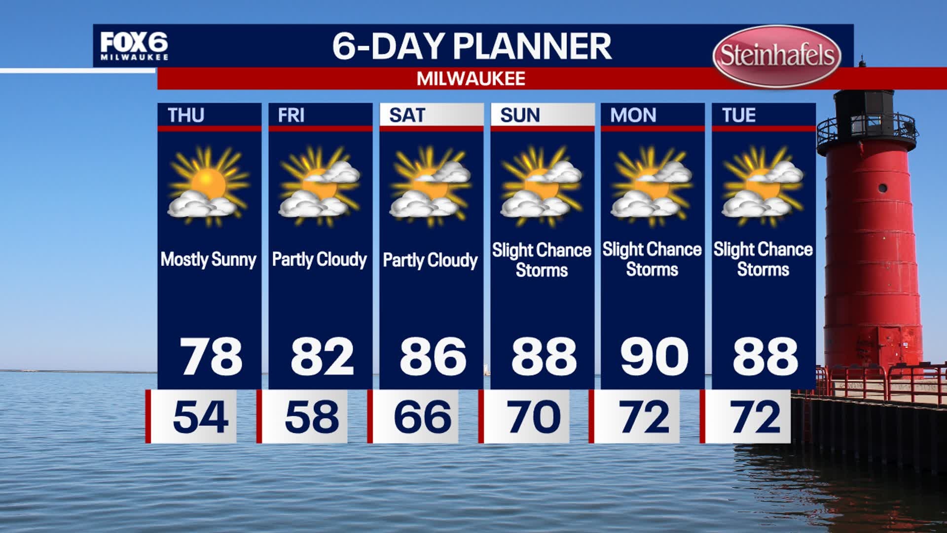
Weather webcast with Lisa Michaels
Clear and calm again tonight with temperatures dropping into the low 50s, possibly 40s inland. A bit warmer Thursday but still comfortable, then low 80s expected on Friday. Heating up this weekend and early next week, with highs in the 80s to around 90. Dew points will also be in the low 70s. Precipitation chances are limited at this time -- potentially a few t-storms Sunday and Tuesday, not nothing major.
Clear and calm again tonight with temperatures dropping into the low 50s, possibly 40s inland. A bit warmer Thursday but still comfortable, then low 80s expected on Friday. Heating up this weekend and early next week, with highs in the 80s to around 90. Dew points will also be in the low 70s. Precipitation chances are limited at this time -- potentially a few t-storms Sunday and Tuesday, not nothing major.


Milwaukee Riverkeeper encourages smart salting, discusses pollution
Milwaukee Riverkeeper said chloride, a component of road salt, can pollute bodies of water that connect to our drinking supply.
Milwaukee Riverkeeper said chloride, a component of road salt, can pollute bodies of water that connect to our drinking supply.