

Weather webcast with Rob Haswell
An active and potentially impactful weather pattern remains locked in across southern Wisconsin, with multiple rounds of strong to severe thunderstorms expected through midweek.
An active and potentially impactful weather pattern remains locked in across southern Wisconsin, with multiple rounds of strong to severe thunderstorms expected through midweek.


Milwaukee Weather: Severe storms tonight
Severe T-Storm Watch for ALL OF SE WI until 4am. Flood Watch Ozaukee, Washington, Dodge, Fond du Lac and Sheboygan Co. until 7am Tuesday
Severe T-Storm Watch for ALL OF SE WI until 4am. Flood Watch Ozaukee, Washington, Dodge, Fond du Lac and Sheboygan Co. until 7am Tuesday
Weather Webcast with Chief Meteorologist Tom Wachs
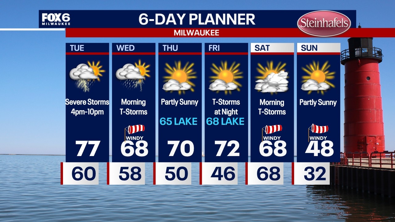
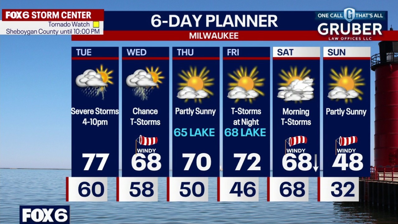
A line of thunderstorms will move into SE WI overnight. Wind, hail and isolated tornadoes are possible. An even stronger setup for severe storms exists on Tuesday afternoon between 4pm-10pm with hail, tornadoes and wind all possible. Highs in the 70s. More severe storms possible on Wednesday. PLEASE stay weather aware and stay tuned for updates
A line of thunderstorms will move into SE WI overnight. Wind, hail and isolated tornadoes are possible. An even stronger setup for severe storms exists on Tuesday afternoon between 4pm-10pm with hail, tornadoes and wind all possible. Highs in the 70s. More severe storms possible on Wednesday. PLEASE stay weather aware and stay tuned for updates
Weather Webcast with Chief Meteorologist Tom Wachs
Tornado Watch Ozaukee, Washington, Dodge, Fond du Lac and Sheboygan Co. until 10pm Monday. Flood Watch Ozaukee, Washington, Dodge, Fond du Lac and Sheboygan Co. until 7am Tuesday
Tornado Watch Ozaukee, Washington, Dodge, Fond du Lac and Sheboygan Co. until 10pm Monday. Flood Watch Ozaukee, Washington, Dodge, Fond du Lac and Sheboygan Co. until 7am Tuesday
Weather Webcast with Stephanie Barichello
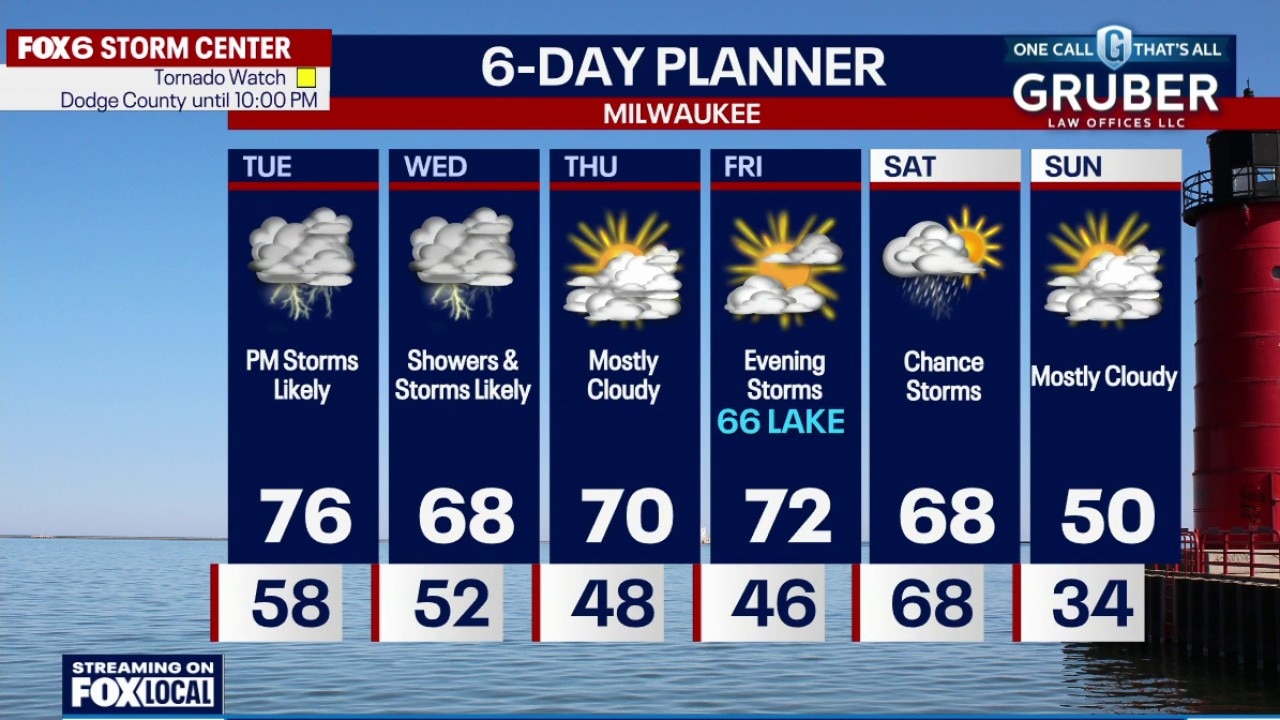
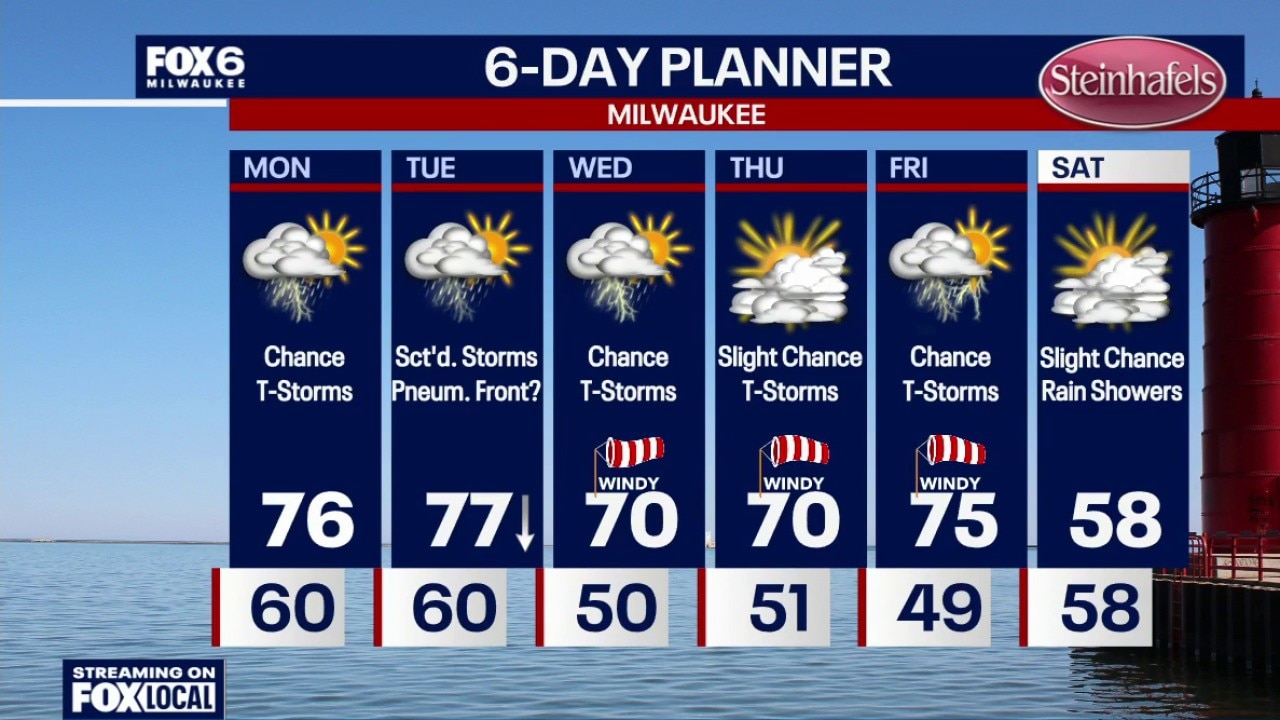
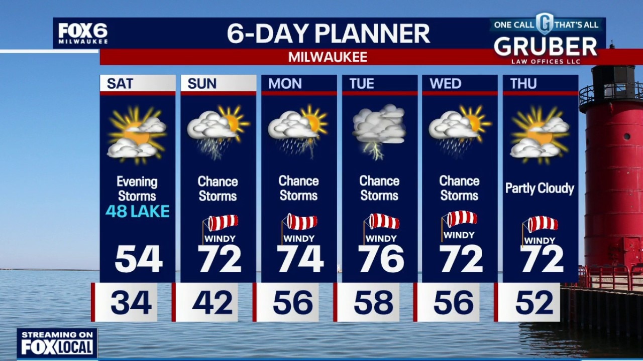
Severe weather is possible late tonight into early Tuesday morning with damaging wind and large hail as the primary threat. Flash flooding may also be an issue, with 1-2" of rain possible across northern counties. More severe weather on the way Tuesday afternoon and evening, then a soggy Wednesday ahead. A brief break late week then one more round of storms Friday night into Saturday.
Severe weather is possible late tonight into early Tuesday morning with damaging wind and large hail as the primary threat. Flash flooding may also be an issue, with 1-2" of rain possible across northern counties. More severe weather on the way Tuesday afternoon and evening, then a soggy Wednesday ahead. A brief break late week then one more round of storms Friday night into Saturday.


Disaster aid approved for seven states, others wait for a decision
Federal disaster relief is starting to flow as the White House approves major disaster declarations for seven states, yet multiple other regions remain in limbo after a series of severe storms and floods dating back to last year.
Federal disaster relief is starting to flow as the White House approves major disaster declarations for seven states, yet multiple other regions remain in limbo after a series of severe storms and floods dating back to last year.


Wisconsin severe weather risk: Rounds of heavy rain, strong storms
All of Wisconsin is under the threat of severe weather Monday afternoon and evening. A tornado watch has been issued for Dodge, Fond du Lac, Washington, Ozaukee, and Sheboygan Counties until 10 p.m.
All of Wisconsin is under the threat of severe weather Monday afternoon and evening. A tornado watch has been issued for Dodge, Fond du Lac, Washington, Ozaukee, and Sheboygan Counties until 10 p.m.
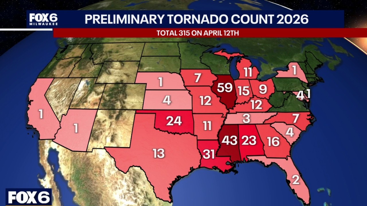
Wisconsin Weather Experts: 2026 Tornado count
With several rounds of rain and an increased potential for severe weather , the FOX6 Weather Experts are also tracking the tornado count in the nation.
With several rounds of rain and an increased potential for severe weather , the FOX6 Weather Experts are also tracking the tornado count in the nation.
Weather webcast with meteorologist Stephanie Barichello
An active and increasingly impactful weather pattern is setting up across southern Wisconsin, with multiple rounds of showers and thunderstorms expected through the end of the week.
An active and increasingly impactful weather pattern is setting up across southern Wisconsin, with multiple rounds of showers and thunderstorms expected through the end of the week.


Severe weather spotter training in West Bend canceled Monday
The Severe Weather Safety & Spotter Training scheduled to take place at the West Bend Police Department on Monday, April 13 has been canceled due to the threat of severe weather.
The Severe Weather Safety & Spotter Training scheduled to take place at the West Bend Police Department on Monday, April 13 has been canceled due to the threat of severe weather.
Weather webcast with Rob Haswell
An active and increasingly impactful weather pattern is setting up across southern Wisconsin, with multiple rounds of showers and thunderstorms expected through the end of the week.
An active and increasingly impactful weather pattern is setting up across southern Wisconsin, with multiple rounds of showers and thunderstorms expected through the end of the week.
Weather Webcast with Chief Meteorologist Tom Wachs
Rainy with showers ending by 2-3am. 0.25"-0.50" of rain likely. Severe weather is unlikely out of this batch. Temperatures in the 60s tonight. Partly sunny, warm and humid on Monday with highs in the mid-70s. The environment will be primed for severe t-storms. While widespread severe storms aren't likely, scattered severe storms are possible.
Rainy with showers ending by 2-3am. 0.25"-0.50" of rain likely. Severe weather is unlikely out of this batch. Temperatures in the 60s tonight. Partly sunny, warm and humid on Monday with highs in the mid-70s. The environment will be primed for severe t-storms. While widespread severe storms aren't likely, scattered severe storms are possible.
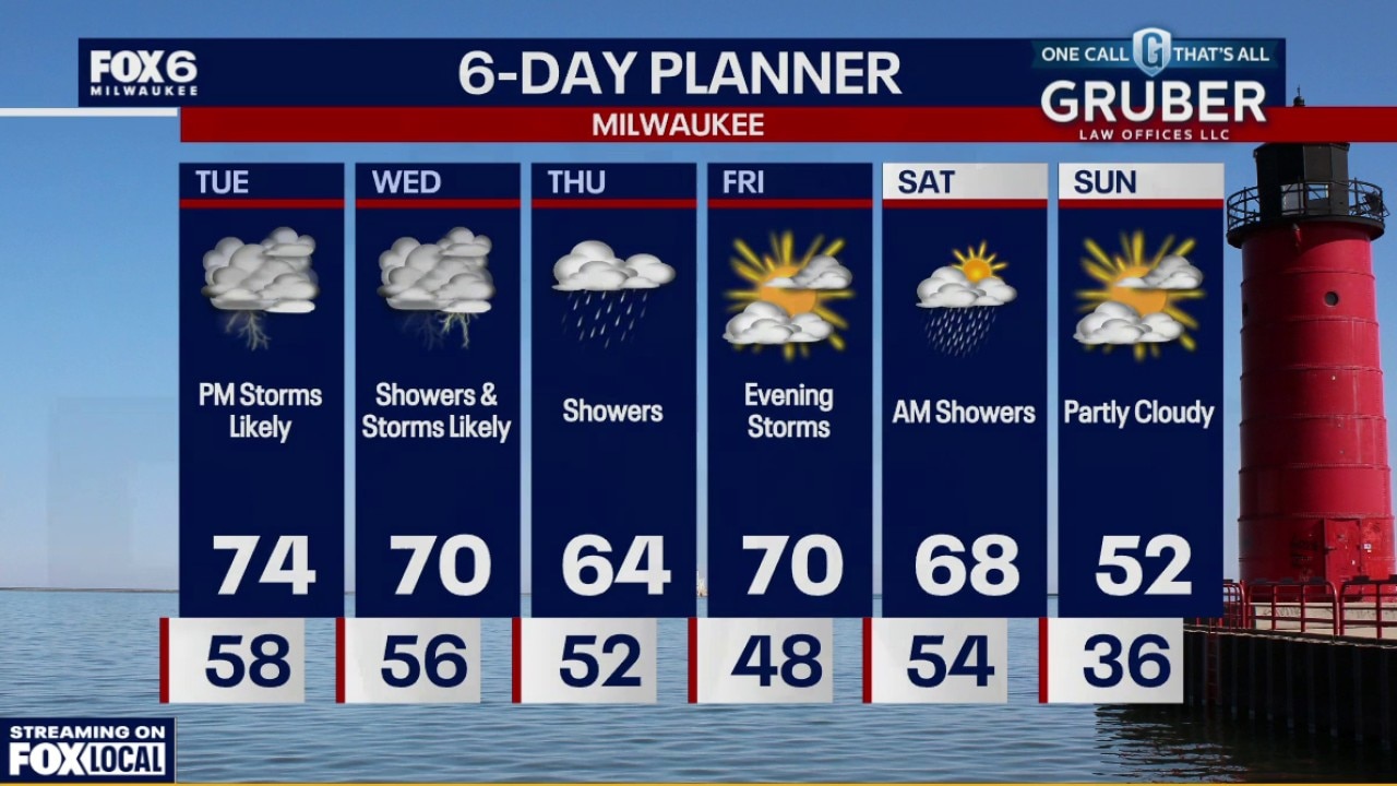
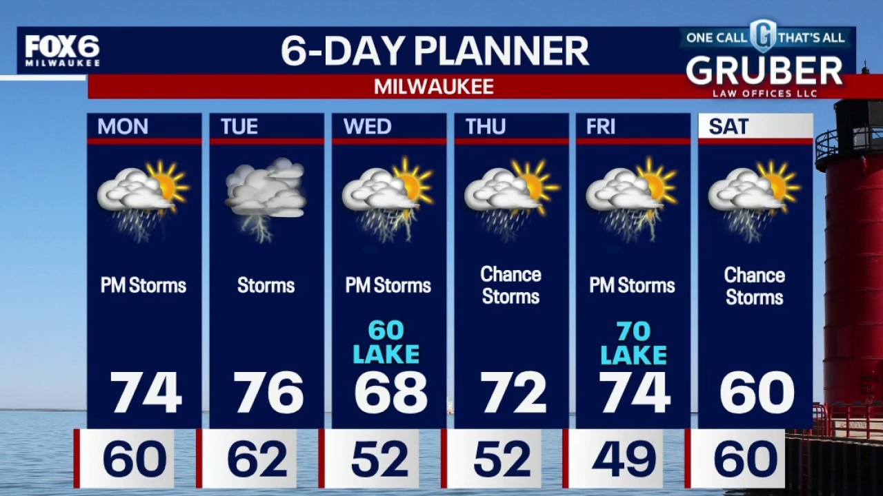
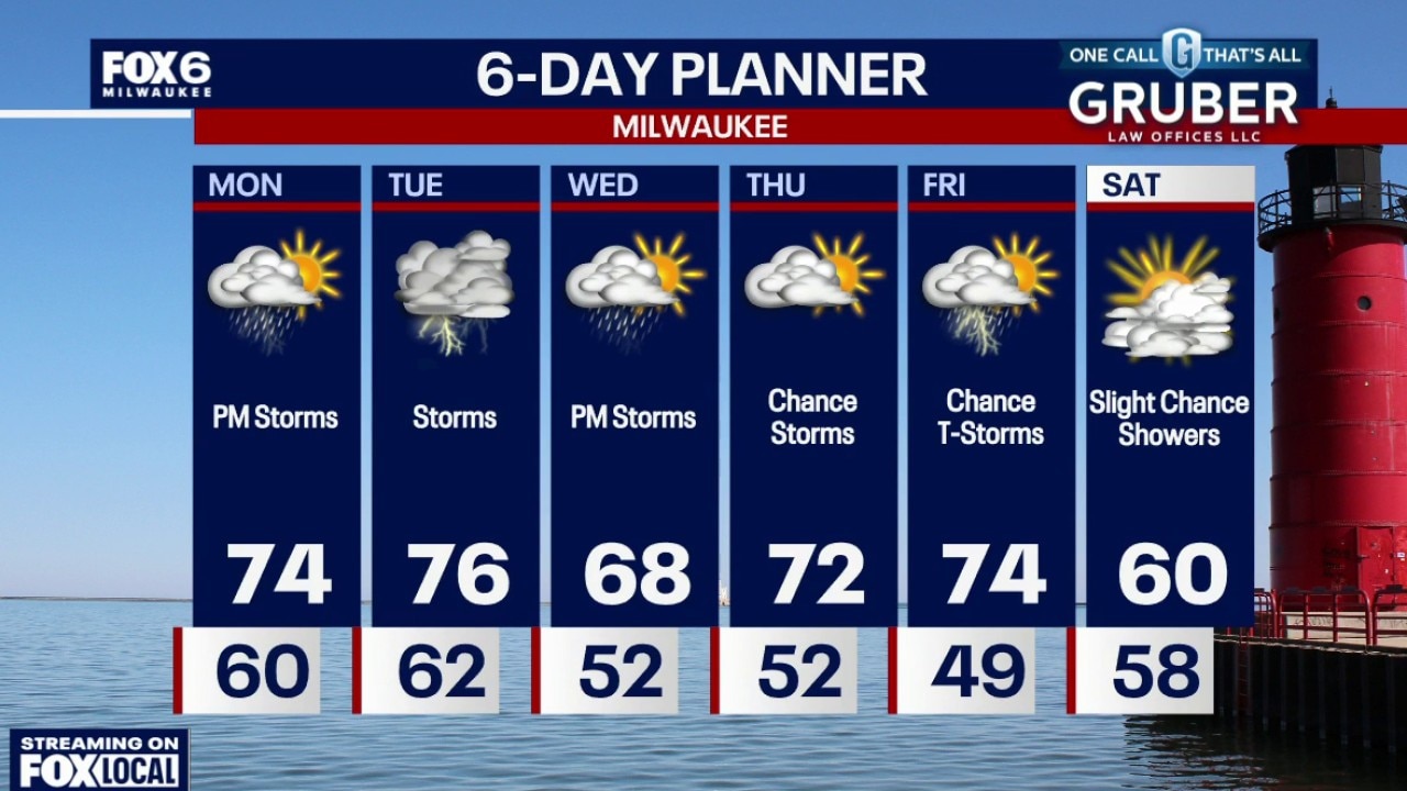
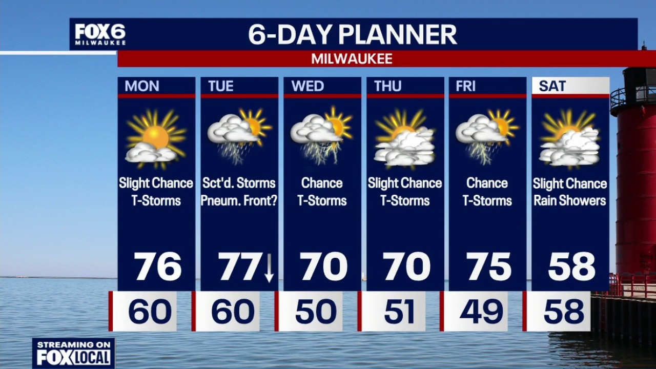
Milwaukee Weather: Scattered rain and storms, warm and humid
Rainy with showers ending by 2-3am. 0.25"-0.50" of rain likely. Severe weather is unlikely out of this batch. Temperatures in the 60s tonight. Partly sunny, warm and humid on Monday with highs in the mid-70s. The environment will be primed for severe t-storms. While widespread severe storms aren't likely, scattered severe storms are possible. We could see a line of storms on Monday night (from the north). Greater risk for scattered severe storms on Tuesday. A pneumonia front is possible on Tuesday afternoon with a steep temp. drop near the lake. More strong t-storm chances on Wednesday and again on Friday.
Rainy with showers ending by 2-3am. 0.25"-0.50" of rain likely. Severe weather is unlikely out of this batch. Temperatures in the 60s tonight. Partly sunny, warm and humid on Monday with highs in the mid-70s. The environment will be primed for severe t-storms. While widespread severe storms aren't likely, scattered severe storms are possible. We could see a line of storms on Monday night (from the north). Greater risk for scattered severe storms on Tuesday. A pneumonia front is possible on Tuesday afternoon with a steep temp. drop near the lake. More strong t-storm chances on Wednesday and again on Friday.
Weather Webcast with Chief Meteorologist Tom Wachs
Rainy tonight with showers and t-storms ending by 3am. 0.25"-0.50" of rain likely. Severe weather is unlikely out of this batch. Temperatures in the 60s tonight.
Rainy tonight with showers and t-storms ending by 3am. 0.25"-0.50" of rain likely. Severe weather is unlikely out of this batch. Temperatures in the 60s tonight.
Weather webcast with meteorologist Lisa Michaels
Southeast Wisconsin will be placed south of a warm front creating the summer-like environment. This also brings daily chances and rounds of rain/storms.
Southeast Wisconsin will be placed south of a warm front creating the summer-like environment. This also brings daily chances and rounds of rain/storms.
Weather Webcast with Holly Baker
We are tracking a chance for storms next week.
We are tracking a chance for storms next week.
Weather webcast with meteorologist Lisa Michaels
Mostly sunny with highs in the low to mid 50s. Chance of rain with embedded thunder arrives Saturday night into Sunday.
Mostly sunny with highs in the low to mid 50s. Chance of rain with embedded thunder arrives Saturday night into Sunday.
Milwaukee Weather: Mostly sunny day then rain and storms tonight
Patchy fog and early morning frost on Saturday. Then mostly sunny with highs in the low to mid 50s.
Patchy fog and early morning frost on Saturday. Then mostly sunny with highs in the low to mid 50s.
Weather Webcast with Holly Baker
We will be tracking warmer temperatures with rain chances by late Saturday.
We will be tracking warmer temperatures with rain chances by late Saturday.
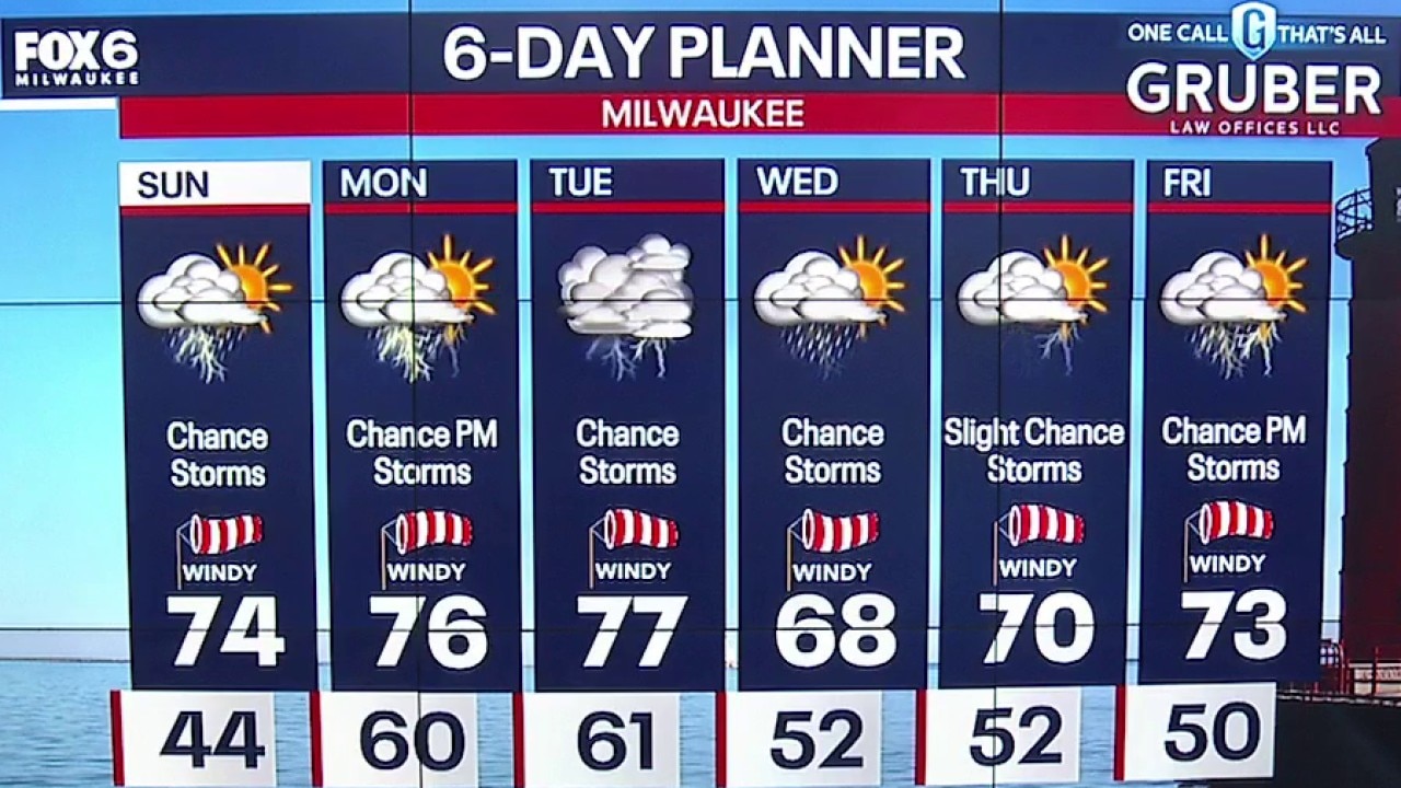
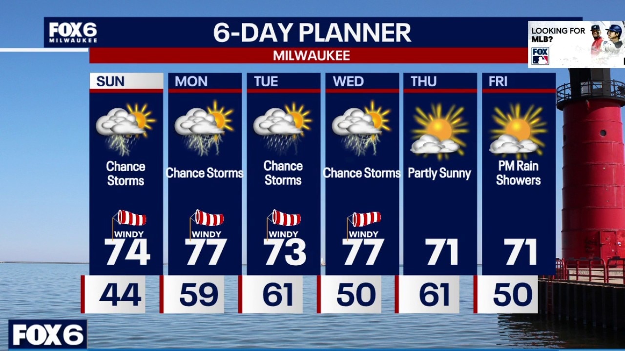
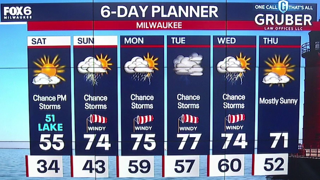
Weather Webcast with Stephanie Barichello
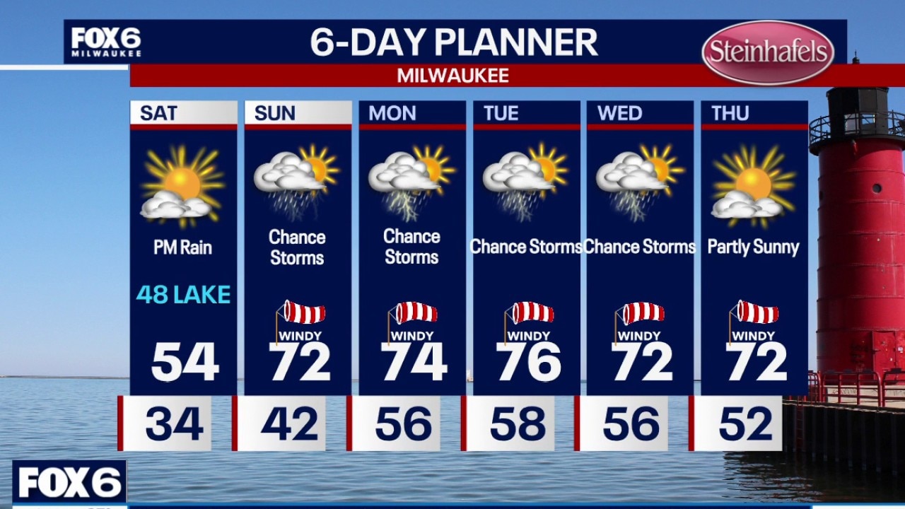
Patchy fog tonight then some sunshine to start on Saturday. Clouds increase by the afternoon with a few showers or storms possible. Better chance for scattered storms on Sunday, it will not be a wash out. Expect a warm and windy stretch of weather next week that comes with a chance of storms most days. Monday and Tuesday could bring a severe threat. Stay tuned.
Patchy fog tonight then some sunshine to start on Saturday. Clouds increase by the afternoon with a few showers or storms possible. Better chance for scattered storms on Sunday, it will not be a wash out. Expect a warm and windy stretch of weather next week that comes with a chance of storms most days. Monday and Tuesday could bring a severe threat. Stay tuned.