

Weather webcast with Rob Haswell
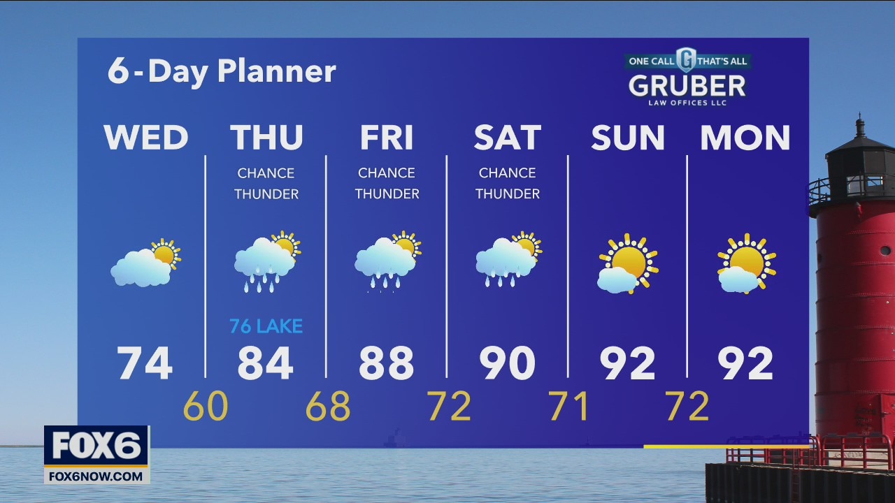
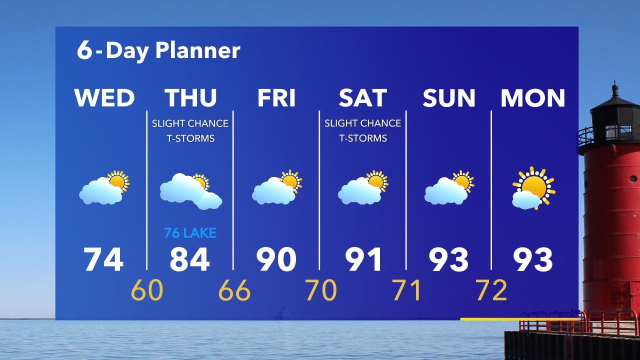
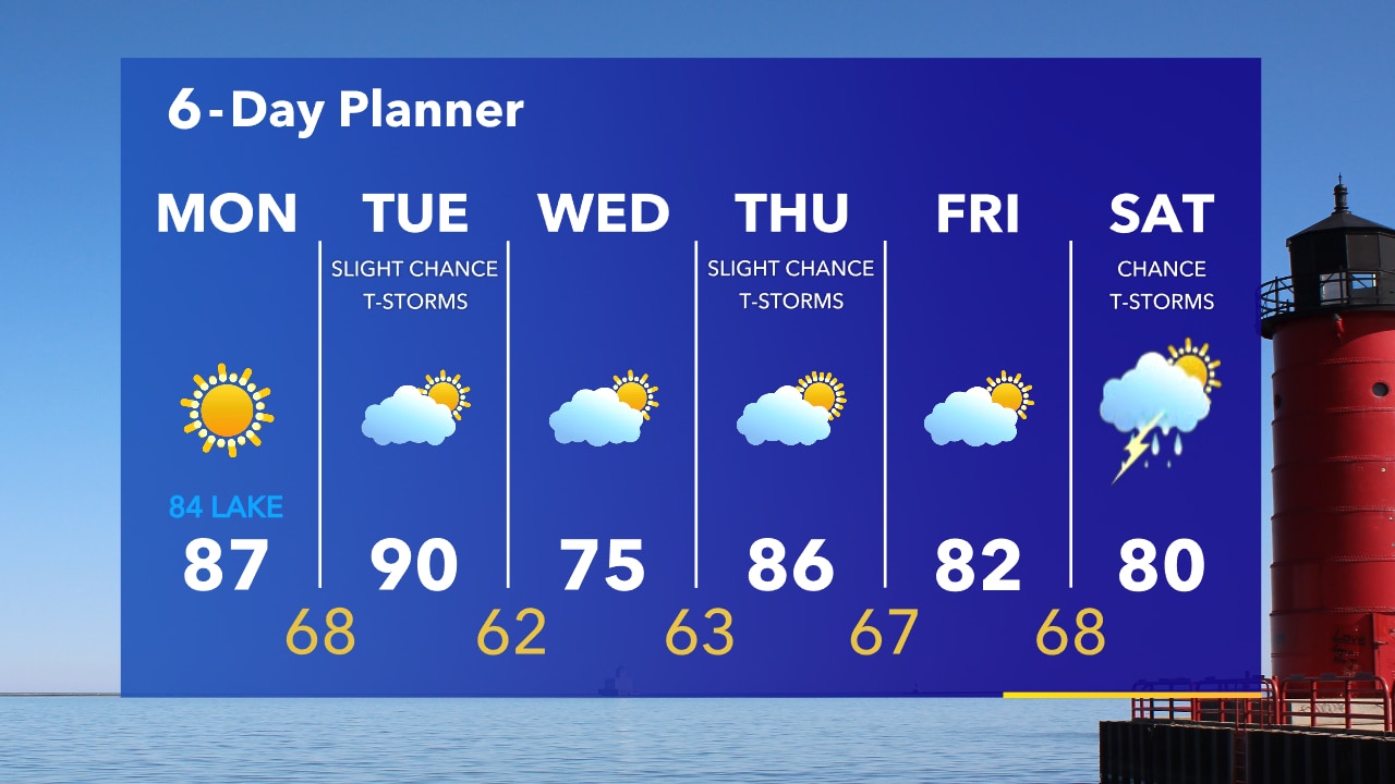
High pressure moves to our east today and a warm front moves across the region bringing in warmer and more humid air over the next couple of days. Highs today will be in the low 80s but a bit cooler near the lake with a southeast breeze. We warm into the upper 80s tomorrow.
High pressure moves to our east today and a warm front moves across the region bringing in warmer and more humid air over the next couple of days. Highs today will be in the low 80s but a bit cooler near the lake with a southeast breeze. We warm into the upper 80s tomorrow.
Weather Webcast with Tom Wachs
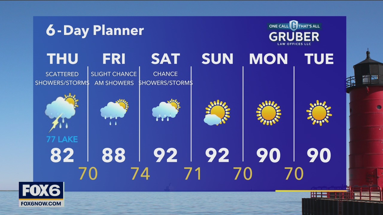
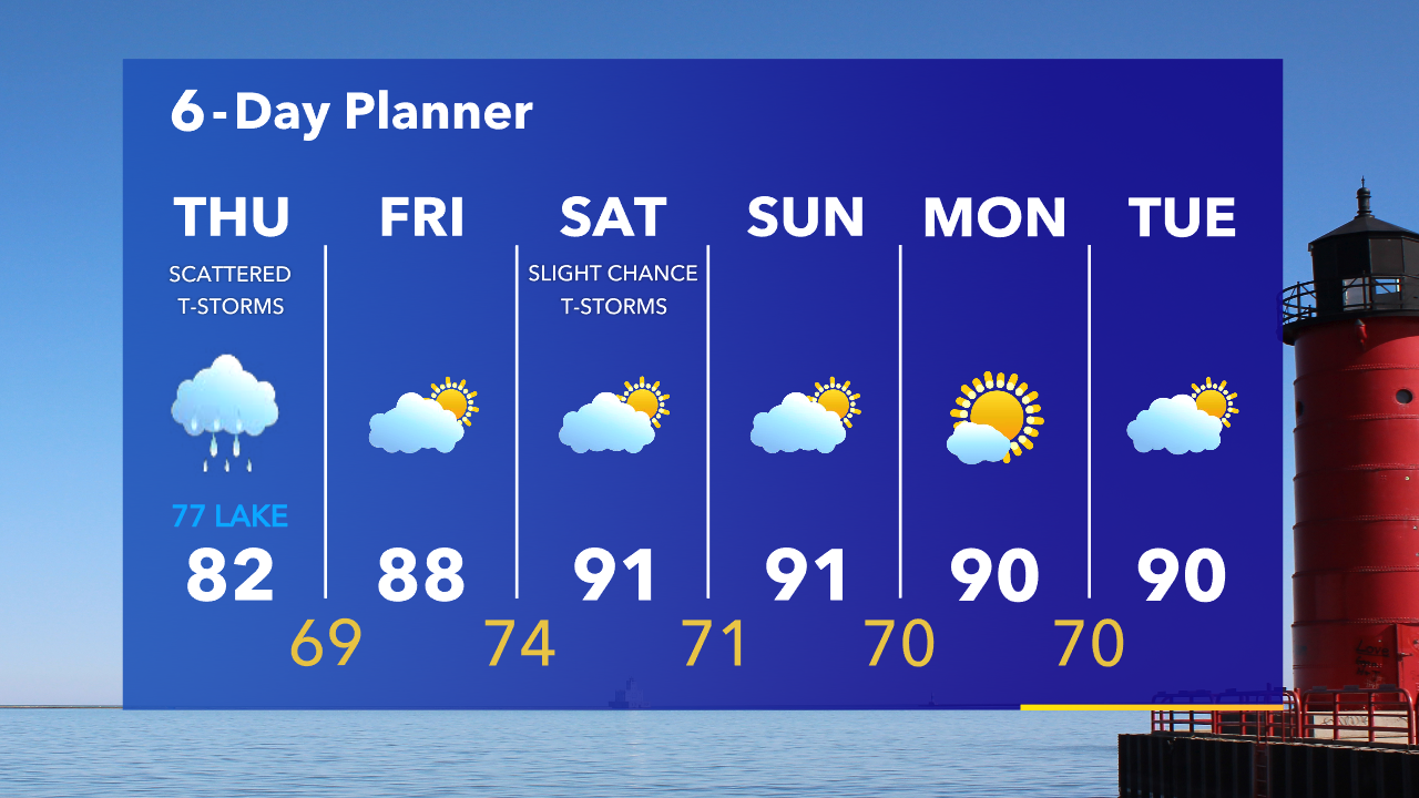
Mostly cloudy and comfortable overnight with temperatures in the 50s by sunrise. Only a slight chance for a stray rain shower on Thursday with higher chances for a shower or t-storm Thursday evening. Highs in the 70s near the lake, low 80s inland.
Mostly cloudy and comfortable overnight with temperatures in the 50s by sunrise. Only a slight chance for a stray rain shower on Thursday with higher chances for a shower or t-storm Thursday evening. Highs in the 70s near the lake, low 80s inland.

Weather Webcast with Tom Wachs
Increasing clouds tonight with comfortable temperatures falling into the 50s overnight. Mostly cloudy with a few scattered showers and thunderstorms Thursday. Highs in the 80s inland, 70s near the lake.
Increasing clouds tonight with comfortable temperatures falling into the 50s overnight. Mostly cloudy with a few scattered showers and thunderstorms Thursday. Highs in the 80s inland, 70s near the lake.
Weather webcast with Rob Haswell
Partly cloudy and cooler today with highs in the low to mid 70s. A chance for rain and thunderstorms returns tomorrow along with warmer temperatures in the low to mid 80s - cooler lakeside.
Partly cloudy and cooler today with highs in the low to mid 70s. A chance for rain and thunderstorms returns tomorrow along with warmer temperatures in the low to mid 80s - cooler lakeside.

Weather Webcast with Tom Wachs
Mostly clear overnight with patchy smoke. Temperatures dropping through the 60s. Increasing clouds on Wednesday with temperatures in the 70s.
Mostly clear overnight with patchy smoke. Temperatures dropping through the 60s. Increasing clouds on Wednesday with temperatures in the 70s.
Weather Webcast with Tom Wachs
Patchy wildfire smoke will continue in our air tonight. An Air Quality Alert has been posted across the state until midnight. Temperatures falling into the 60s this evening. Partly sunny on Wednesday with highs in the middle 70s.
Patchy wildfire smoke will continue in our air tonight. An Air Quality Alert has been posted across the state until midnight. Temperatures falling into the 60s this evening. Partly sunny on Wednesday with highs in the middle 70s.
Weather Webcast with A.J. Waterman
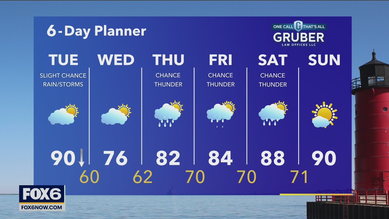
Hot and humid to start today, but a backdoor front is looking to cool things down this afternoon!
Hot and humid to start today, but a backdoor front is looking to cool things down this afternoon!
Weather webcast with Rob Haswell
Watching a strong "backdoor cold front" today which may be strong enough to earn the title of "pneumonia front" as it will drop temperatures very quickly. Early highs will be near 90 and then we fall into the 70s by later in the afternoon and into the 60s this evening and overnight.
Watching a strong "backdoor cold front" today which may be strong enough to earn the title of "pneumonia front" as it will drop temperatures very quickly. Early highs will be near 90 and then we fall into the 70s by later in the afternoon and into the 60s this evening and overnight.

Weather Webcast with Tom Wachs
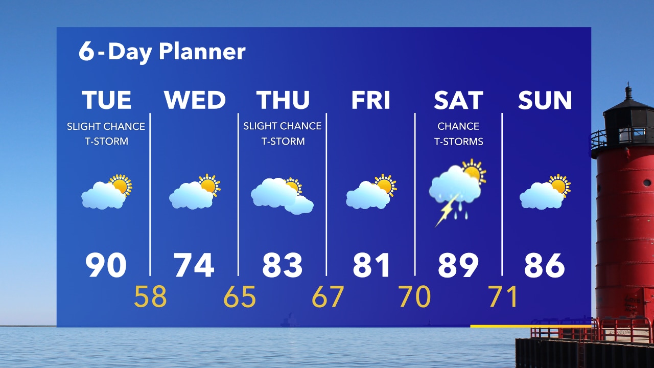
Mostly clear overnight with temperatures falling into the 60s. Partly sunny on Tuesday with a slight chance for a t-storm. BIG temperature drop in the afternoon from 90 to 70s. 60s at 8pm in the Deer District.
Mostly clear overnight with temperatures falling into the 60s. Partly sunny on Tuesday with a slight chance for a t-storm. BIG temperature drop in the afternoon from 90 to 70s. 60s at 8pm in the Deer District.
Weather Webcast with Tom Wachs
Mostly clear tonight with temperatures falling through the 70s. Partly sunny on Tuesday with a midday high around 90. A sharp cold front comes in during the afternoon rapidly dropping temperatures into the 70s.
Mostly clear tonight with temperatures falling through the 70s. Partly sunny on Tuesday with a midday high around 90. A sharp cold front comes in during the afternoon rapidly dropping temperatures into the 70s.
Weather Webcast with Rob Haswell
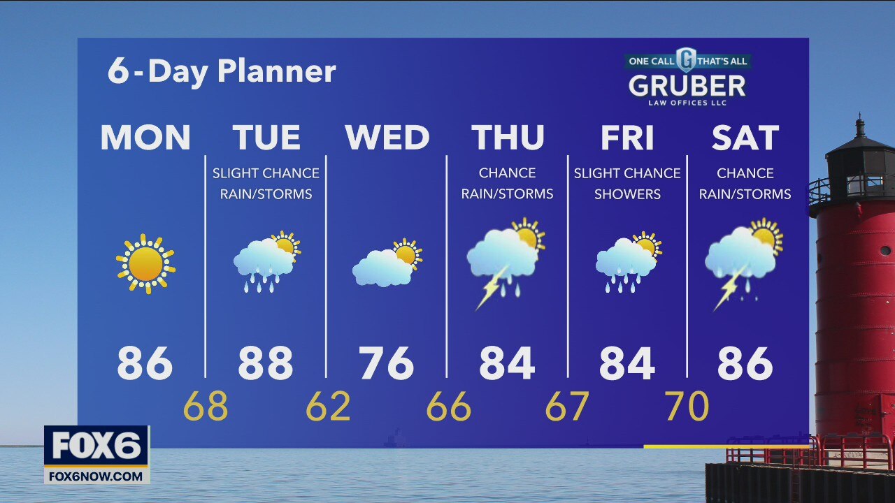
High pressure drifts across the area today keeping us sunny and dry. Highs will warm to the mid and upper 80s today with slightly elevated dew points. A low develops to the NE tomorrow and drops south dragging a cold front across our areas on Tuesday. Ahead of that front we'll be in the upper 80s but the front will cool us significantly.
High pressure drifts across the area today keeping us sunny and dry. Highs will warm to the mid and upper 80s today with slightly elevated dew points. A low develops to the NE tomorrow and drops south dragging a cold front across our areas on Tuesday. Ahead of that front we'll be in the upper 80s but the front will cool us significantly.

Weather Webcast with Tom Wachs
Clear skies overnight. Temperatures dropping into the upper 50s to low 60s by sunrise. Sunny and warm on Monday with highs in the 80s. Warm on Tuesday before a BIG late day temperature drop.
Clear skies overnight. Temperatures dropping into the upper 50s to low 60s by sunrise. Sunny and warm on Monday with highs in the 80s. Warm on Tuesday before a BIG late day temperature drop.
Weather Webcast with Tom Wachs
Clear and comfortable tonight with temperatures dropping into the upper 50s to low 60s by sunrise. Sunny and warm on Monday. Slight chance for a t-storm Tuesday. BIG temperature drop Tuesday evening.
Clear and comfortable tonight with temperatures dropping into the upper 50s to low 60s by sunrise. Sunny and warm on Monday. Slight chance for a t-storm Tuesday. BIG temperature drop Tuesday evening.
Weather Webcast with Eric Manges
Sunny skies once again with high temperatures getting into the low 80s. Highs return to the upper 80s for Monday with skies staying sunny and clear.
Sunny skies once again with high temperatures getting into the low 80s. Highs return to the upper 80s for Monday with skies staying sunny and clear.
Weather Webcast with A.J. Waterman
Another gorgeous summer day Sunday! Heat returns next week...
Another gorgeous summer day Sunday! Heat returns next week...
Weather Webcast with Eric Manges
The weather is looking fantastic this weekend with sunny skies and seasonable temperatures. We keep warming up into Monday with high temperatures back into the mid-80s and sunny skies.
The weather is looking fantastic this weekend with sunny skies and seasonable temperatures. We keep warming up into Monday with high temperatures back into the mid-80s and sunny skies.
Weather Webcast with A.J. Waterman
A gorgeous weekend in store for us with sunshine and drier weather. Heat and humidity returns next week...
A gorgeous weekend in store for us with sunshine and drier weather. Heat and humidity returns next week...
Weather Webcast with A.J. Waterman
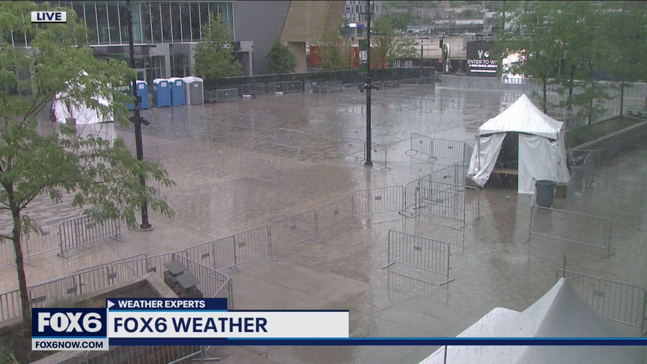
Tracking storms moving through the area this evening.
Tracking storms moving through the area this evening.
Weather Webcast with A.J. Waterman
Nice weekend weather for us! Heat returns next week with a few rain chances...
Nice weekend weather for us! Heat returns next week with a few rain chances...
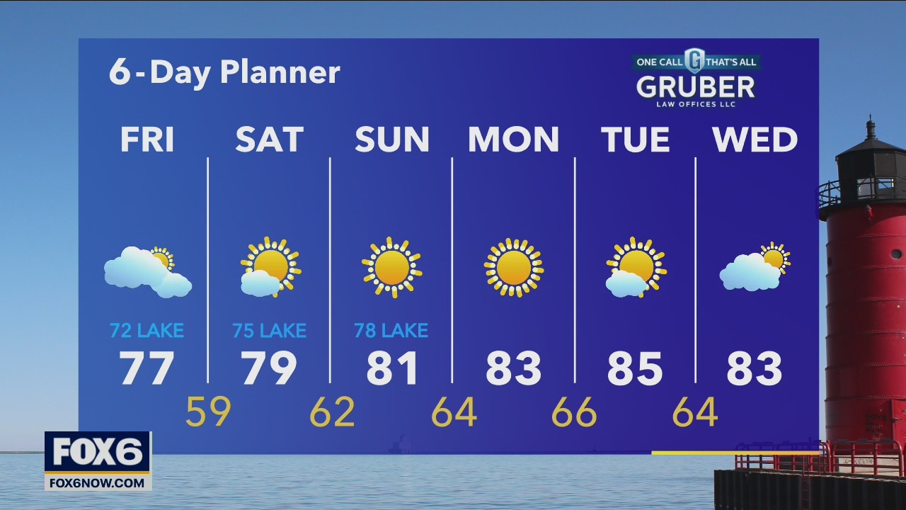
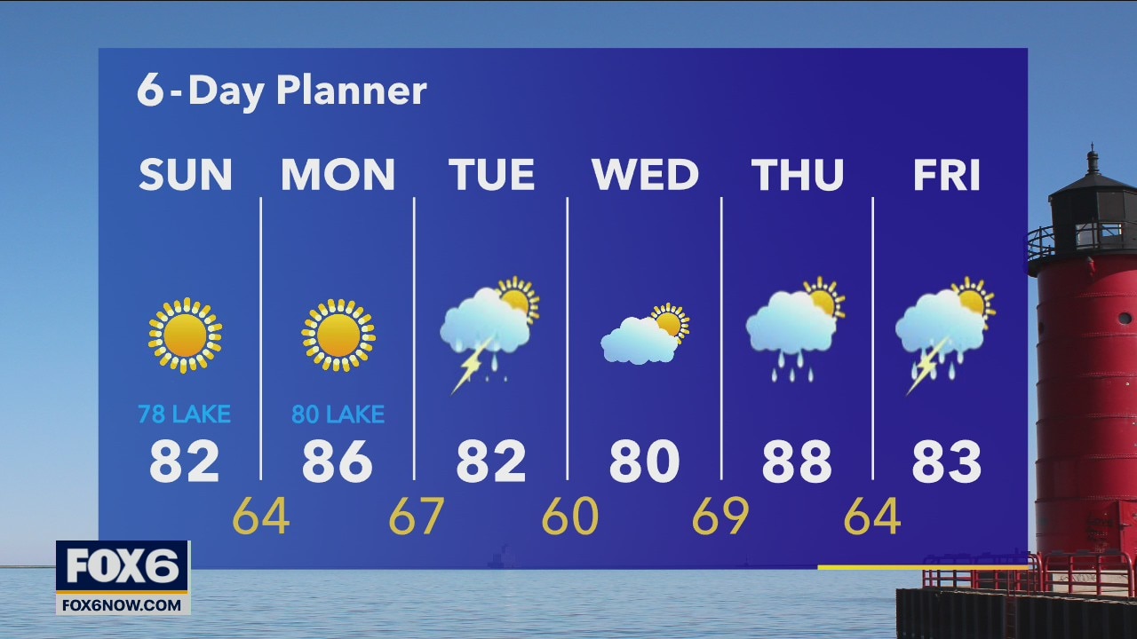
Weather webcast with Rob Haswell
Sunday high pressure dominates and gives us sunshine and warmer temperatures lasting through the beginning of next week. Long-term precip trends keep us drying than average and that's consistent in the 6-day with little to no rain chances.
Sunday high pressure dominates and gives us sunshine and warmer temperatures lasting through the beginning of next week. Long-term precip trends keep us drying than average and that's consistent in the 6-day with little to no rain chances.