


Weather Webcast with Tom Wachs
Mostly clear to partly cloudy tonight. Temperatures in the 30s. Mostly cloudy with a light mix possible midday Wednesday. Highs in the low 40s.
Mostly clear to partly cloudy tonight. Temperatures in the 30s. Mostly cloudy with a light mix possible midday Wednesday. Highs in the low 40s.
Weather Webcast with Meteorologist Stephanie Barichello
Dropping temperatures as a lake breeze kicks in this afternoon then warming back into the 40s on Wednesday. There is a chance for light snow in the morning then light rain in the evening. Another system brings rain this weekend.
Dropping temperatures as a lake breeze kicks in this afternoon then warming back into the 40s on Wednesday. There is a chance for light snow in the morning then light rain in the evening. Another system brings rain this weekend.

Weather webcast with Rob Haswell
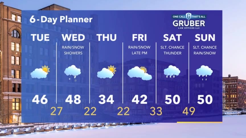
A series of low pressure systems pass through our area in the next few days. Today a weak cold front clears with just a slight chance for a few sprinkles but a better chance of rain and snow showers will arrive tomorrow. Highs today and tomorrow will be in the mid to upper 40s but we will cool to the low 30s Thursday.
A series of low pressure systems pass through our area in the next few days. Today a weak cold front clears with just a slight chance for a few sprinkles but a better chance of rain and snow showers will arrive tomorrow. Highs today and tomorrow will be in the mid to upper 40s but we will cool to the low 30s Thursday.
Weather Webcast with Tom Wachs
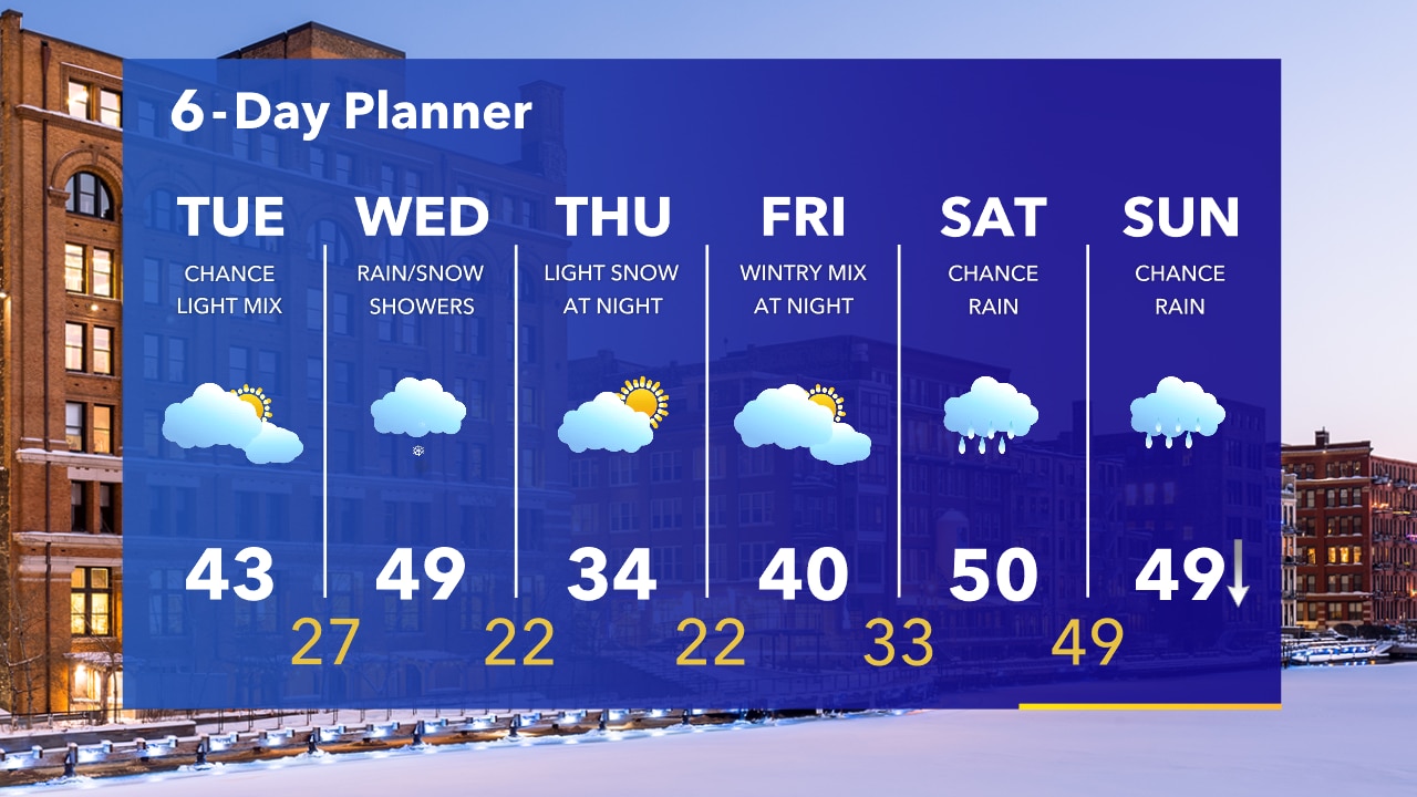
Increasing clouds overnight with temperatures in the 30s. A few light rain or snow showers possible on Tuesday, but it shouldn't be a big deal. Temperatures in the 40s, cooler near the lake in the afternoon.
Increasing clouds overnight with temperatures in the 30s. A few light rain or snow showers possible on Tuesday, but it shouldn't be a big deal. Temperatures in the 40s, cooler near the lake in the afternoon.
Weather Webcast with Tom Wachs
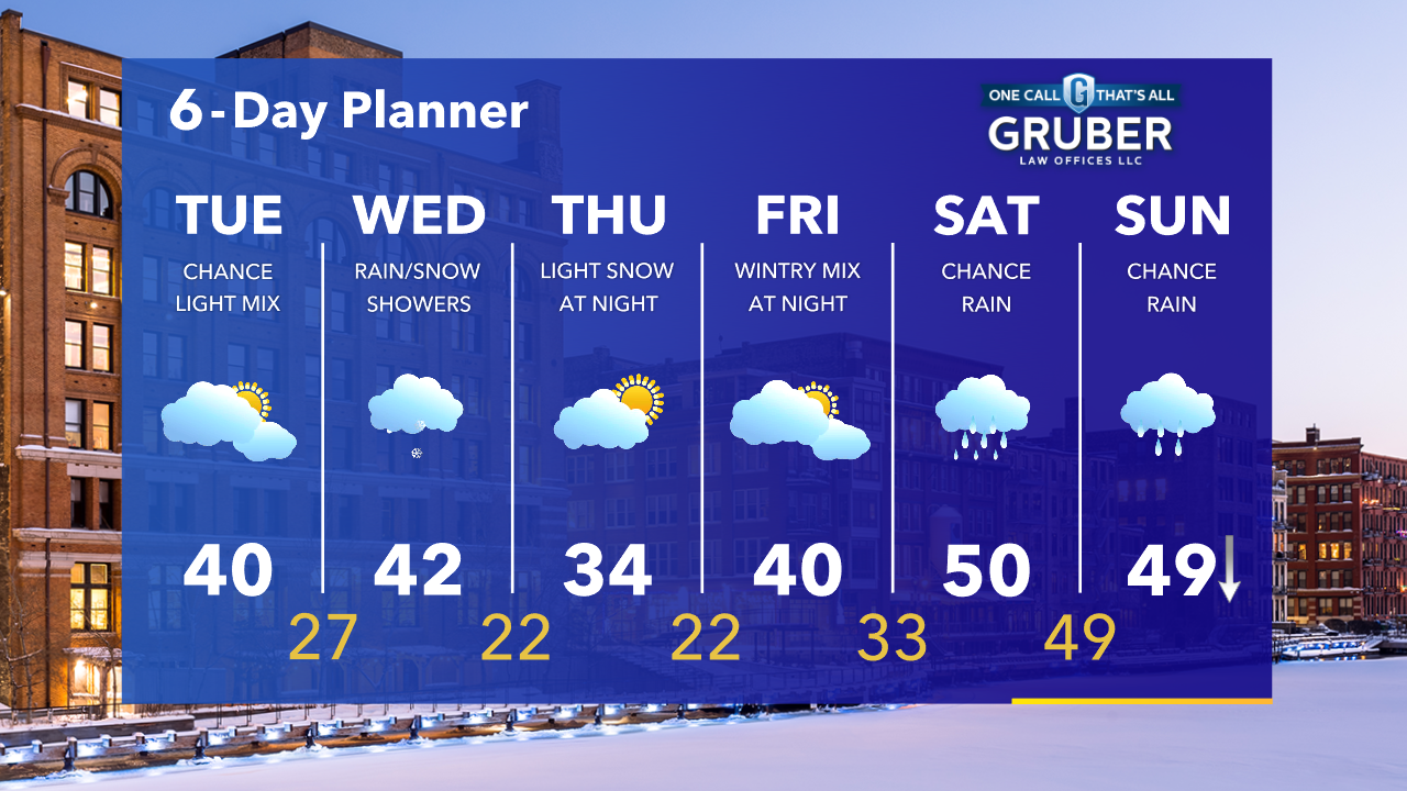
Increasing clouds tonight with temperatures in the 30s. Mostly cloudy on Tuesday with a few light rain/snow showers mid-to-late morning. Highs around 40 but dropping near the lake in the afternoon.
Increasing clouds tonight with temperatures in the 30s. Mostly cloudy on Tuesday with a few light rain/snow showers mid-to-late morning. Highs around 40 but dropping near the lake in the afternoon.
Weather Webcast with Meteorologist Stephanie Barichello
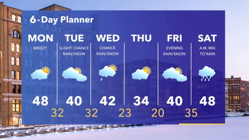
Sunny and mild today, then there is a slight chance for mixed precipitation Tuesday and Wednesday. Colder Thursday then back to 40s this weekend.
Sunny and mild today, then there is a slight chance for mixed precipitation Tuesday and Wednesday. Colder Thursday then back to 40s this weekend.
Weather webcast with Rob Haswell
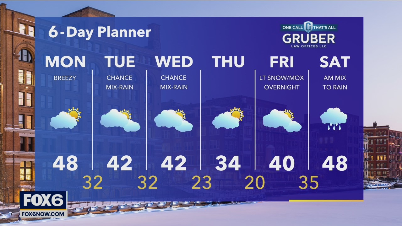
A warm front lifts to our north today helping us warm up. We should get to the upper 40s today. There is a slight chance for a wintry mix or rain on Tuesday and again on Wednesday. We stay seasonally mild with highs in the low 40s. We cool down a bit Thursday but a low arrives on Friday and into Saturday to warm us up and bring us some rain and snow.
A warm front lifts to our north today helping us warm up. We should get to the upper 40s today. There is a slight chance for a wintry mix or rain on Tuesday and again on Wednesday. We stay seasonally mild with highs in the low 40s. We cool down a bit Thursday but a low arrives on Friday and into Saturday to warm us up and bring us some rain and snow.
Weather Webcast with Tom Wachs
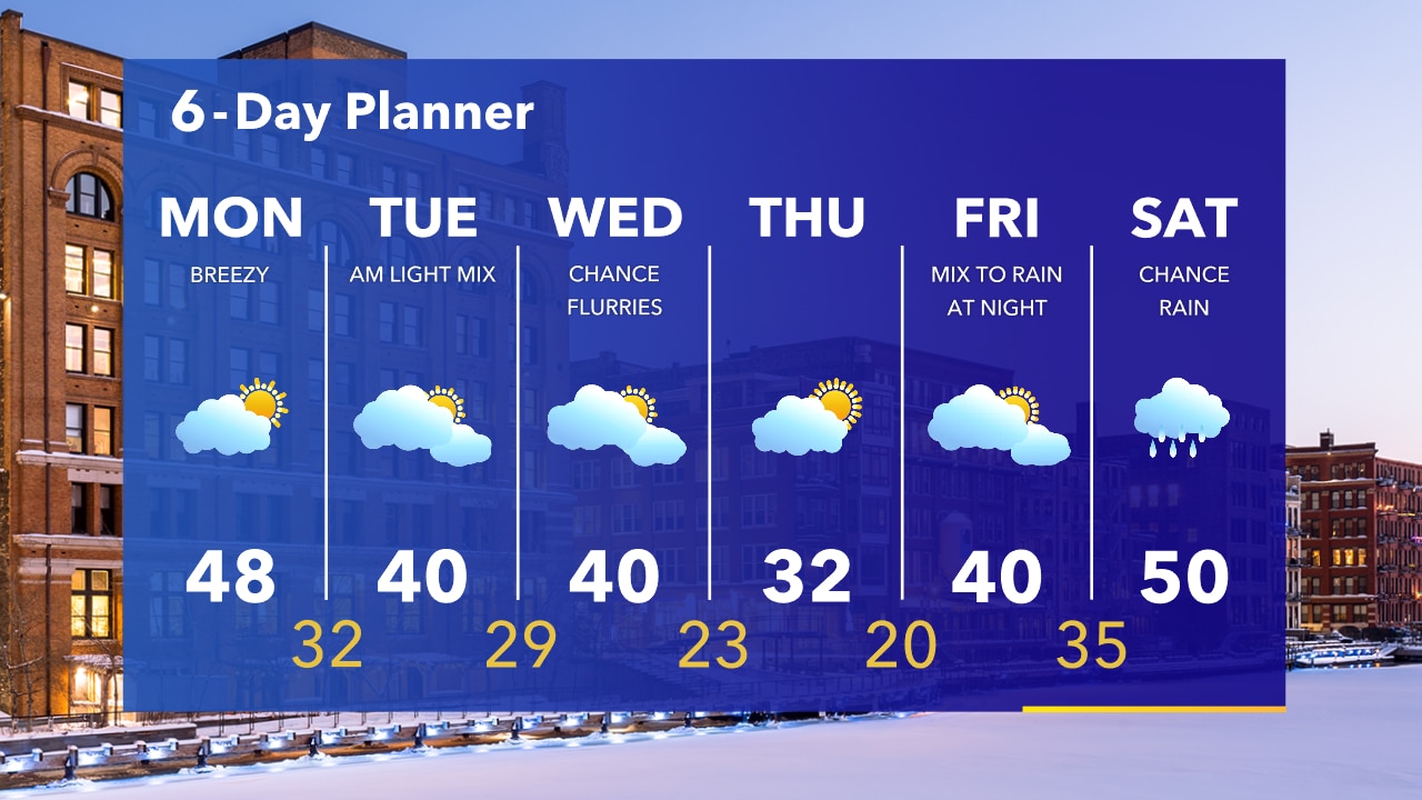
Partly cloudy and breezy on Monday. Highs in the middle 40s to around 50 in spots...except Sheboygan which will stay in the 30s. A light mix is possible Tuesday morning.
Partly cloudy and breezy on Monday. Highs in the middle 40s to around 50 in spots...except Sheboygan which will stay in the 30s. A light mix is possible Tuesday morning.
Weather Webcast with Tom Wachs
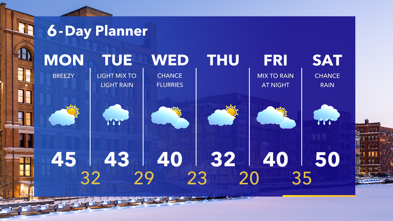
Temperatures will rapidly fall into the 20s this evening. Partly sunny, breezy and mild on Monday. Highs in the 40s in most areas, except north of Milwaukee (ie. Sheboygan) where temperatures will stay in the 30s.
Temperatures will rapidly fall into the 20s this evening. Partly sunny, breezy and mild on Monday. Highs in the 40s in most areas, except north of Milwaukee (ie. Sheboygan) where temperatures will stay in the 30s.
Weather Webcast with Eric Manges
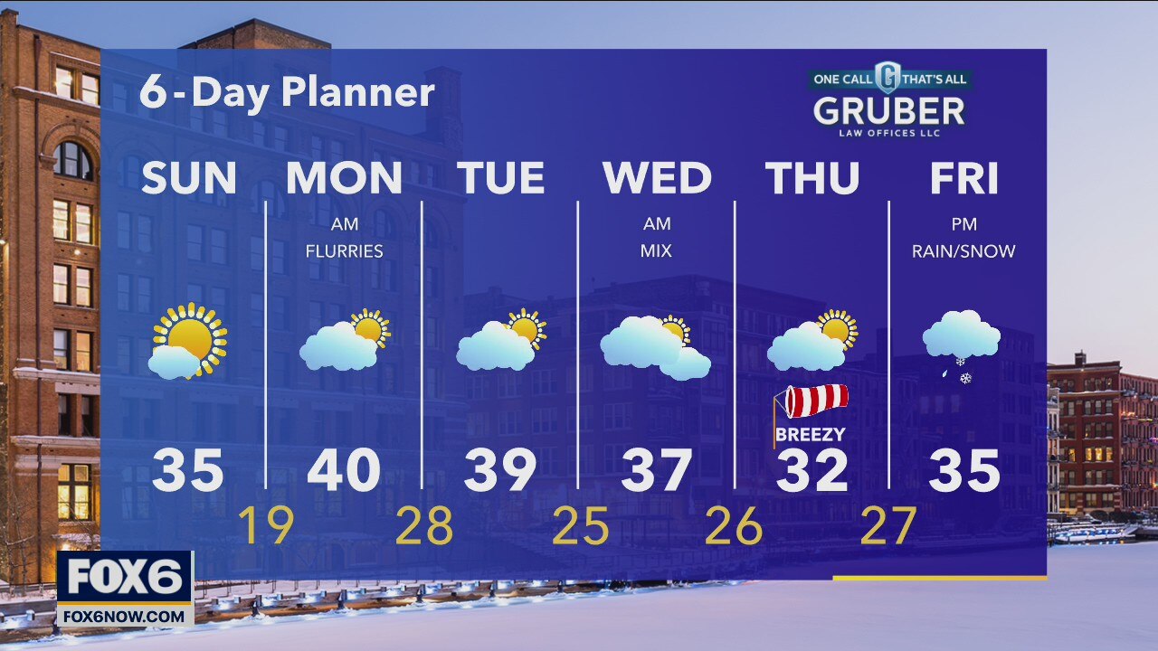
Mostly sunny skies today with high temperatures getting into the mid-30s. Few flurries overnight leading to partly cloudy skies for Monday as highs get to near 40.
Mostly sunny skies today with high temperatures getting into the mid-30s. Few flurries overnight leading to partly cloudy skies for Monday as highs get to near 40.
Weather Webcast with Eric Manges
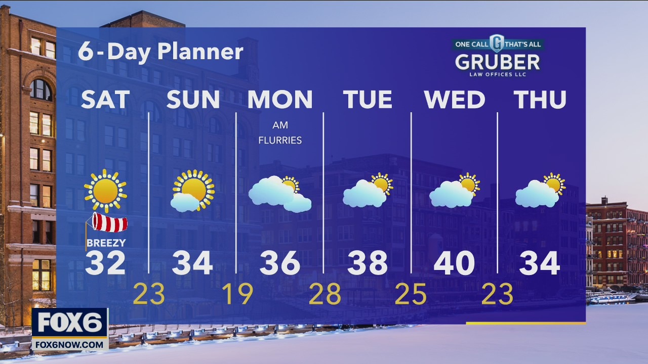
Sunshine and warmer temps as highs get into the low 30s this afternoon. Breezy winds slowly calm into tomorrow with a few more clouds Sunday.
Sunshine and warmer temps as highs get into the low 30s this afternoon. Breezy winds slowly calm into tomorrow with a few more clouds Sunday.
Weather Webcast with Meteorologist Stephanie Barichello
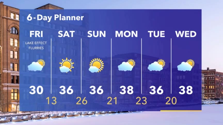
A few lake effect flurries this afternoon otherwise sunny with temperatures around 30. A lot of melting ahead this weekend with middle 30s and sunshine in the forecast.
A few lake effect flurries this afternoon otherwise sunny with temperatures around 30. A lot of melting ahead this weekend with middle 30s and sunshine in the forecast.
Weather webcast with Rob Haswell
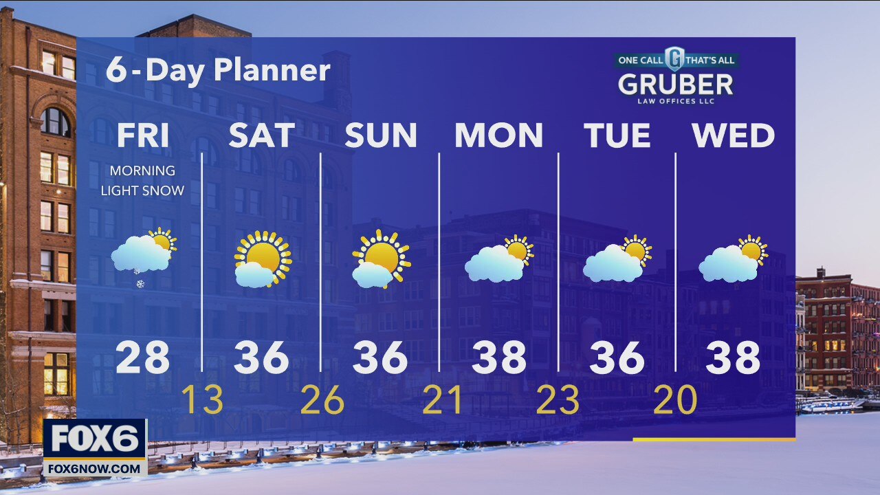
High pressure builds in from the west today causing our snow to wind down and clouds to clear. Temperatures remain cool today with highs in the upper 20s but we warm into the mid to upper 30s with sunny conditions this weekend. We stay calm through the middle of next week with seasonal temperatures.
High pressure builds in from the west today causing our snow to wind down and clouds to clear. Temperatures remain cool today with highs in the upper 20s but we warm into the mid to upper 30s with sunny conditions this weekend. We stay calm through the middle of next week with seasonal temperatures.
Weather Webcast with Tom Wachs
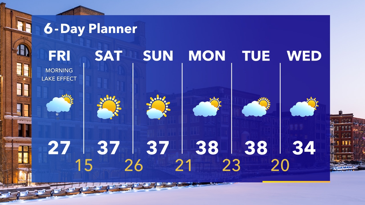
Snow ends around 4am. 2-4" most areas, slightly higher in spots near the lake. Light snow possible near the lake Friday morning otherwise dry with afternoon highs in the 20s.
Snow ends around 4am. 2-4" most areas, slightly higher in spots near the lake. Light snow possible near the lake Friday morning otherwise dry with afternoon highs in the 20s.
Weather Webcast with Tom Wachs
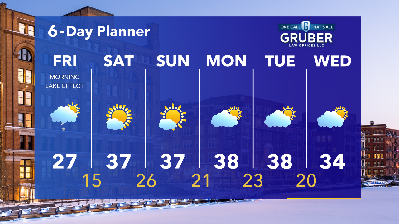
Winter Weather Advisory tonight. Heaviest snow 10pm-2am. Greatest accumulation near the lake. 2-4" most areas, a few isolated 5-6" amounts possible. Snow ends around 4am with a lake effect band lingering Friday AM.
Winter Weather Advisory tonight. Heaviest snow 10pm-2am. Greatest accumulation near the lake. 2-4" most areas, a few isolated 5-6" amounts possible. Snow ends around 4am with a lake effect band lingering Friday AM.

Weather Webcast with Meteorologist Stephanie Barichello
A Winter Weather Advisory starts at 3pm and ends at 6am Friday. Several inches of snow possible tonight then drying out this weekend with warming temperatures.
A Winter Weather Advisory starts at 3pm and ends at 6am Friday. Several inches of snow possible tonight then drying out this weekend with warming temperatures.

Weather webcast with Eric Manges
Light snow chances continue through the morning but taper off by midday. The next round of snow arrives this evening. Winter Weather Advisory goes into effect at 3 pm and continues through Friday 6 am. 2"-4" are expected for most while areas closest to the lake could get up to 6".
Light snow chances continue through the morning but taper off by midday. The next round of snow arrives this evening. Winter Weather Advisory goes into effect at 3 pm and continues through Friday 6 am. 2"-4" are expected for most while areas closest to the lake could get up to 6".
Weather Webcast with Tom Wachs
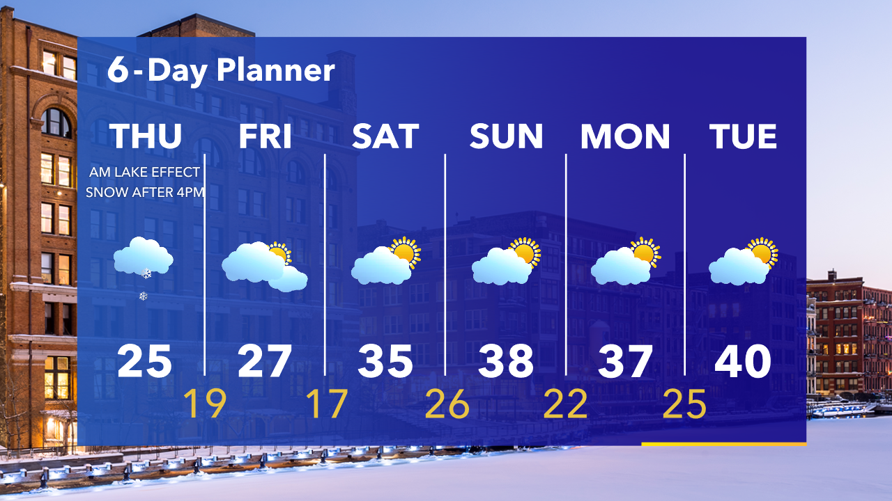
A lake effect snow band could produce less than 1" of accumulation near the lake overnight. Most of the day Thursday is dry. Steady snow moves in mainly after the PM commute. 2-4" inland, 4-6" closer to the lake.
A lake effect snow band could produce less than 1" of accumulation near the lake overnight. Most of the day Thursday is dry. Steady snow moves in mainly after the PM commute. 2-4" inland, 4-6" closer to the lake.
Weather Webcast with Tom Wachs
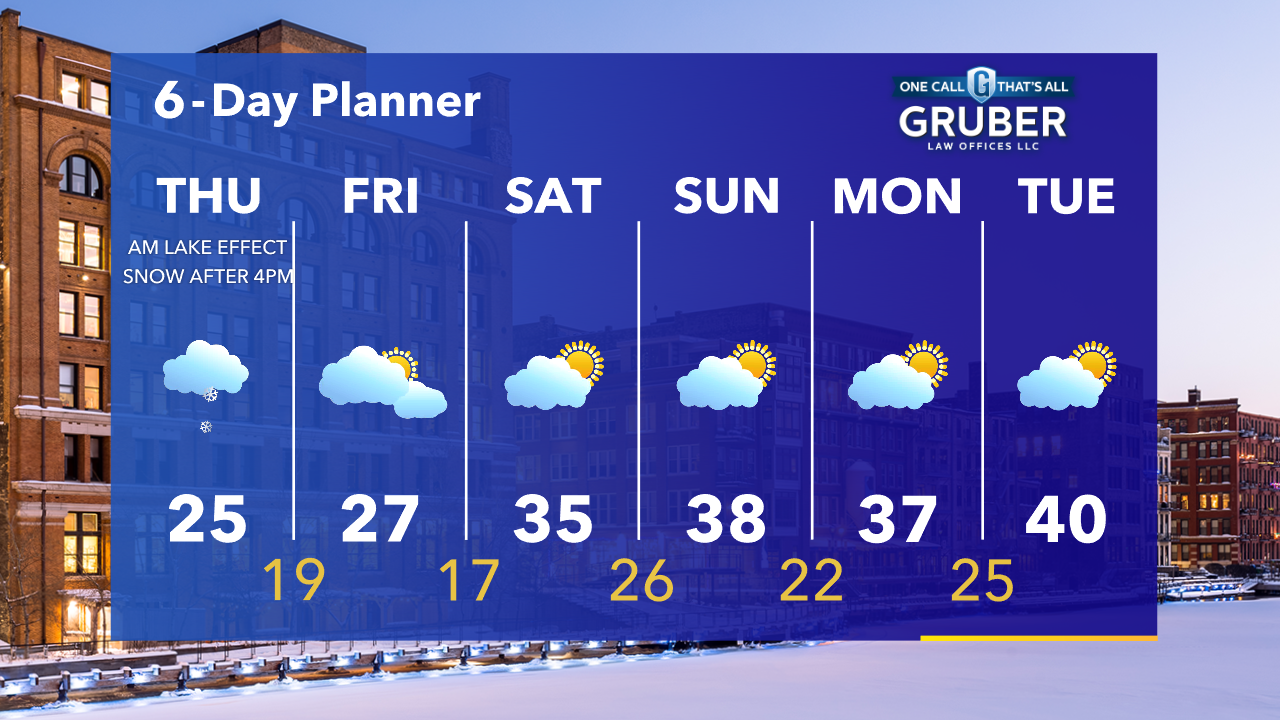
Lake effect snow is possible late tonight. 0.5"-1" possible. Steady snow moves in after 4pm Thursday and continues into early Friday morning. 2-4" most areas, 4-6" near the lake.
Lake effect snow is possible late tonight. 0.5"-1" possible. Steady snow moves in after 4pm Thursday and continues into early Friday morning. 2-4" most areas, 4-6" near the lake.
Weather webcast with Rob Haswell
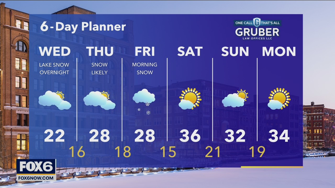
High pressure builds across our region today with cold air but calmer conditions. Highs today will be in the low 20s. The wind will shift to the NE overnight and may generate some light lake effect snow.
High pressure builds across our region today with cold air but calmer conditions. Highs today will be in the low 20s. The wind will shift to the NE overnight and may generate some light lake effect snow.