


Weather Webcast with Meteorologist Stephanie Barichello
Light snow tonight with up to 1" possible by morning, then cold in the days ahead. Bigger late week storm Wednesday night to Friday night could bring blizzard conditions and high snowfall totals. Stay tuned.
Light snow tonight with up to 1" possible by morning, then cold in the days ahead. Bigger late week storm Wednesday night to Friday night could bring blizzard conditions and high snowfall totals. Stay tuned.

Weather webcast with Rob Haswell
High pressure is in charge of our forecast giving us some sunshine but we can also expect a few snow showers. Highs will be in the low to mid 20s today. A low arrives tomorrow and slightly boosts temperatures while bringing another round of snow showers. A much stronger low is expected by Thursday and into Friday. This system has the potential to bring significant snow and very strong wind gusts.
High pressure is in charge of our forecast giving us some sunshine but we can also expect a few snow showers. Highs will be in the low to mid 20s today. A low arrives tomorrow and slightly boosts temperatures while bringing another round of snow showers. A much stronger low is expected by Thursday and into Friday. This system has the potential to bring significant snow and very strong wind gusts.

Weather Webcast with Tom Wachs
Clear and cold overnight with wind chills below zero. Increasing clouds on Monday with a chance for snow at night. Highs in the 20s.
Clear and cold overnight with wind chills below zero. Increasing clouds on Monday with a chance for snow at night. Highs in the 20s.

Weather Webcast with Tom Wachs
Cold tonight with temperatures in the single digits to around 10 by sunrise. Increasing clouds on Monday with a high in the mid-20s. Light snow showers Monday night.
Cold tonight with temperatures in the single digits to around 10 by sunrise. Increasing clouds on Monday with a high in the mid-20s. Light snow showers Monday night.

Weather Webcast with Meteorologist Stephanie Barichello
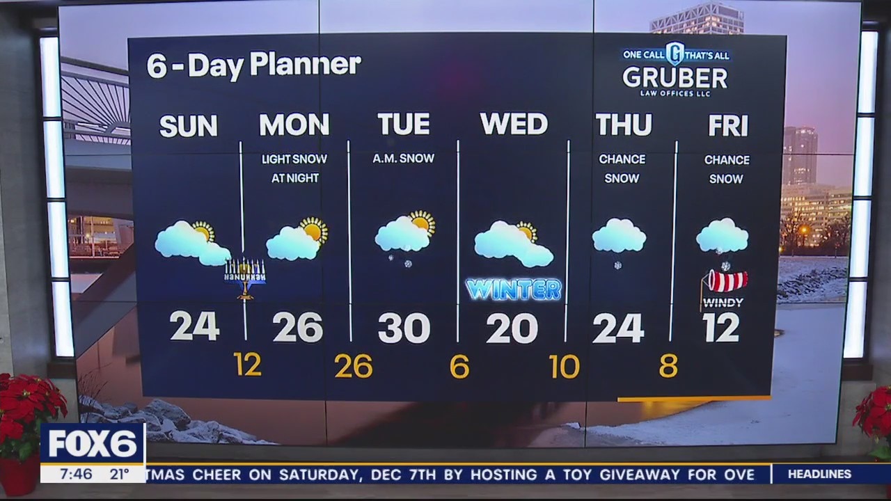
A cold and blustery day today but we should see a few peeks of sunshine at times! A quick round of light snow Monday night then a bigger storm by the end of the week.
A cold and blustery day today but we should see a few peeks of sunshine at times! A quick round of light snow Monday night then a bigger storm by the end of the week.
Weather Webcast with Meteorologist Stephanie Barichello
Peeks of sunshine return today but it'll be blustery and cold with air temperatures in the 20s, wind chills in the single digits. Temperatures fall into the teens tonight then mid 20s Monday. There is a chance for light snow Monday night into Tuesday morning, then potentially a bigger system Wednesday night through Friday. That system will usher in the coldest air of the season for the start to the holiday weekend.
Peeks of sunshine return today but it'll be blustery and cold with air temperatures in the 20s, wind chills in the single digits. Temperatures fall into the teens tonight then mid 20s Monday. There is a chance for light snow Monday night into Tuesday morning, then potentially a bigger system Wednesday night through Friday. That system will usher in the coldest air of the season for the start to the holiday weekend.

Weather Webcast with Meteorologist Eric Manges
FOX6 News at 6 offers the day's news, weather, and sports in southeast Wisconsin, the nation, and the world.
FOX6 News at 6 offers the day's news, weather, and sports in southeast Wisconsin, the nation, and the world.

Weather Webcast With Lisa Michaels
Scattered snow showers will linger into the start of the weekend. Up to half an inch can accumulate. Below average high temps only in the upper 20s Saturday and the low 20s by Sunday. Breaks between clouds Sunday could finally give us peaks of sunshine. Coldest air of the season pushes in near the middle and end of next week. Periods of snow possible as well.
Scattered snow showers will linger into the start of the weekend. Up to half an inch can accumulate. Below average high temps only in the upper 20s Saturday and the low 20s by Sunday. Breaks between clouds Sunday could finally give us peaks of sunshine. Coldest air of the season pushes in near the middle and end of next week. Periods of snow possible as well.

Weather Webcast with Meteorologist Lisa Michaels
Scattered snow showers will linger into the start of the weekend. Up to half an inch can accumulate. Below average high temps only in the upper 20s Saturday and the low 20s by Sunday. Breaks between clouds Sunday could finally give us peaks of sunshine. Coldest air of the season pushes in near the middle and end of next week. Periods of snow possible as well.
Scattered snow showers will linger into the start of the weekend. Up to half an inch can accumulate. Below average high temps only in the upper 20s Saturday and the low 20s by Sunday. Breaks between clouds Sunday could finally give us peaks of sunshine. Coldest air of the season pushes in near the middle and end of next week. Periods of snow possible as well.

Weather Webcast with Meteorologist Eric Manges
FOX6 News at 4 offers the days news, weather and sports in southeast Wisconsin, the nation, and the world.
FOX6 News at 4 offers the days news, weather and sports in southeast Wisconsin, the nation, and the world.

Weather Webcast with Meteorologist Stephanie Barichello
Light snow at times tonight and tomorrow, then some sunshine on Sunday. Expect chilly and blustery conditions through the weekend.
Light snow at times tonight and tomorrow, then some sunshine on Sunday. Expect chilly and blustery conditions through the weekend.

Weather webcast with Rob Haswell
A cut off low continues to wobble around our area today giving us a few snow showers and helping to ramp up the SW wind with gusts 25-30mph at times. We will be much cooler today with a high barely reaching 30. We cool to the teens and low 20s tonight and only get to the upper 20s for Saturday. A few more snow showers are possible Saturday before we finally clear up on Sunday.
A cut off low continues to wobble around our area today giving us a few snow showers and helping to ramp up the SW wind with gusts 25-30mph at times. We will be much cooler today with a high barely reaching 30. We cool to the teens and low 20s tonight and only get to the upper 20s for Saturday. A few more snow showers are possible Saturday before we finally clear up on Sunday.

Weather Webcast with Tom Wachs
Scattered snow showers overnight with temperatures in the 20s. Off-and-on snow showers on Friday with a blustery high in the upper 20s.
Scattered snow showers overnight with temperatures in the 20s. Off-and-on snow showers on Friday with a blustery high in the upper 20s.

Weather Webcast with Tom Wachs
Scattered snow showers tonight with temperatures falling into the 20s. Off-and-on snow showers continue on Friday with a blustery high in the 20s.
Scattered snow showers tonight with temperatures falling into the 20s. Off-and-on snow showers continue on Friday with a blustery high in the 20s.

Weather Webcast with Meteorologist Stephanie Barichello
Light snow still possible at times today, tonight and tomorrow. An additional inch or two of accumulation possible by Saturday morning. Very cold this weekend and early next week.
Light snow still possible at times today, tonight and tomorrow. An additional inch or two of accumulation possible by Saturday morning. Very cold this weekend and early next week.

Weather webcast with Rob Haswell
Winter Weather Advisory for Waukesha, Jefferson, Dodge, Washington, Ozaukee, Fond du Lac and Sheboygan ends at 7am. Steady rain and snow is winding down this morning and will be followed by a few snow showers through the day today. Temperatures will be steady in the upper 30s. A few more snow showers are expected on Friday.
Winter Weather Advisory for Waukesha, Jefferson, Dodge, Washington, Ozaukee, Fond du Lac and Sheboygan ends at 7am. Steady rain and snow is winding down this morning and will be followed by a few snow showers through the day today. Temperatures will be steady in the upper 30s. A few more snow showers are expected on Friday.

Weather Webcast with Tom Wachs
Update on the wintry weather rolling through overnight. Heavy, wet snow accumulation inland with more of a mix near the lake. Precipitation ends by 5am.
Update on the wintry weather rolling through overnight. Heavy, wet snow accumulation inland with more of a mix near the lake. Precipitation ends by 5am.

Weather Webcast with Tom Wachs
Messy weather overnight with rain, sleet, heavy snow and thunder. Changeover starts around 10pm and ends at 5am. Use caution on the roads.
Messy weather overnight with rain, sleet, heavy snow and thunder. Changeover starts around 10pm and ends at 5am. Use caution on the roads.

Weather Webcast with Meteorologist Stephanie Barichello
Rainy and windy today then expect wintry mix and slushy snow overnight, with at least 2-4" inland. Lakeshore communities will likely pick up less accumulation. Light snow still possible Thursday and Friday then the cold sets in.
Rainy and windy today then expect wintry mix and slushy snow overnight, with at least 2-4" inland. Lakeshore communities will likely pick up less accumulation. Light snow still possible Thursday and Friday then the cold sets in.

Weather webcast with Rob Haswell
A strong low continues to impact our area today and through into Thursday. We can expect rain, heavy rain, snow and strong wind gusts. A Winter Weather Advisory has been issued for Sheboygan and Fond du Lac counties as well as areas farther north. Rain will continue today with periods of heavy rain and a strong SE wind gusting to near 40mph at times. Rain transitions to a wintry mix and snow overnight with 1-4" possibly - mostly north if I-94.
A strong low continues to impact our area today and through into Thursday. We can expect rain, heavy rain, snow and strong wind gusts. A Winter Weather Advisory has been issued for Sheboygan and Fond du Lac counties as well as areas farther north. Rain will continue today with periods of heavy rain and a strong SE wind gusting to near 40mph at times. Rain transitions to a wintry mix and snow overnight with 1-4" possibly - mostly north if I-94.