

Weather webcast with Rob Haswell
We’re squeezing out one more round of light snow Wednesday morning, but this is more nuisance than headline less than an inch for most. A quick shot of some patchy freezing drizzle possibly mid-morning as well.
We’re squeezing out one more round of light snow Wednesday morning, but this is more nuisance than headline less than an inch for most. A quick shot of some patchy freezing drizzle possibly mid-morning as well.
Weather Webcast with Chief Meteorologist Tom Wachs
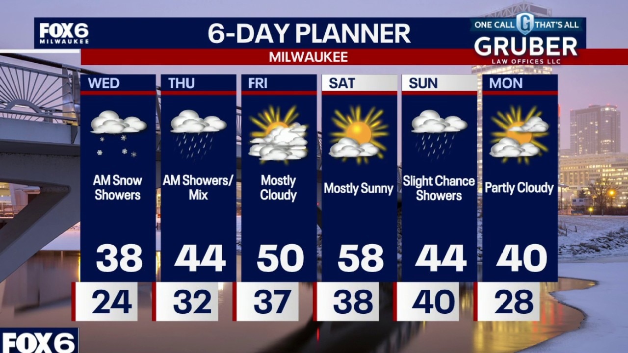
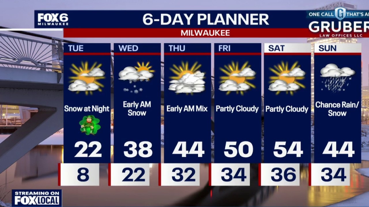
Increasing clouds overnight with light snow. The snow will end by 7am. 1" or less of accumulation possible. Temperatures will slowly rise through the 20s. Early AM snow on Wednesday, ending by 7am. Mostly cloudy with highs in the upper 30s. Rain showers (mixed with freezing rain at times) overnight Wednesday night.
Increasing clouds overnight with light snow. The snow will end by 7am. 1" or less of accumulation possible. Temperatures will slowly rise through the 20s. Early AM snow on Wednesday, ending by 7am. Mostly cloudy with highs in the upper 30s. Rain showers (mixed with freezing rain at times) overnight Wednesday night.
Weather Webcast with Chief Meteorologist Tom Wachs
Increasing clouds tonight with snow after 11pm. The snow will end by 7am. Around 1" of accumulation possible. Temperatures will slowly rise through the 20s overnight. Early AM snow on Wednesday, ending by 7am. Mostly cloudy with highs in the upper 30s. Rain showers (mixed with freezing rain at times) overnight Wednesday night.
Increasing clouds tonight with snow after 11pm. The snow will end by 7am. Around 1" of accumulation possible. Temperatures will slowly rise through the 20s overnight. Early AM snow on Wednesday, ending by 7am. Mostly cloudy with highs in the upper 30s. Rain showers (mixed with freezing rain at times) overnight Wednesday night.
Weather Webcast with Stephanie Barichello
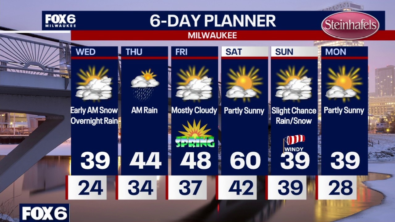
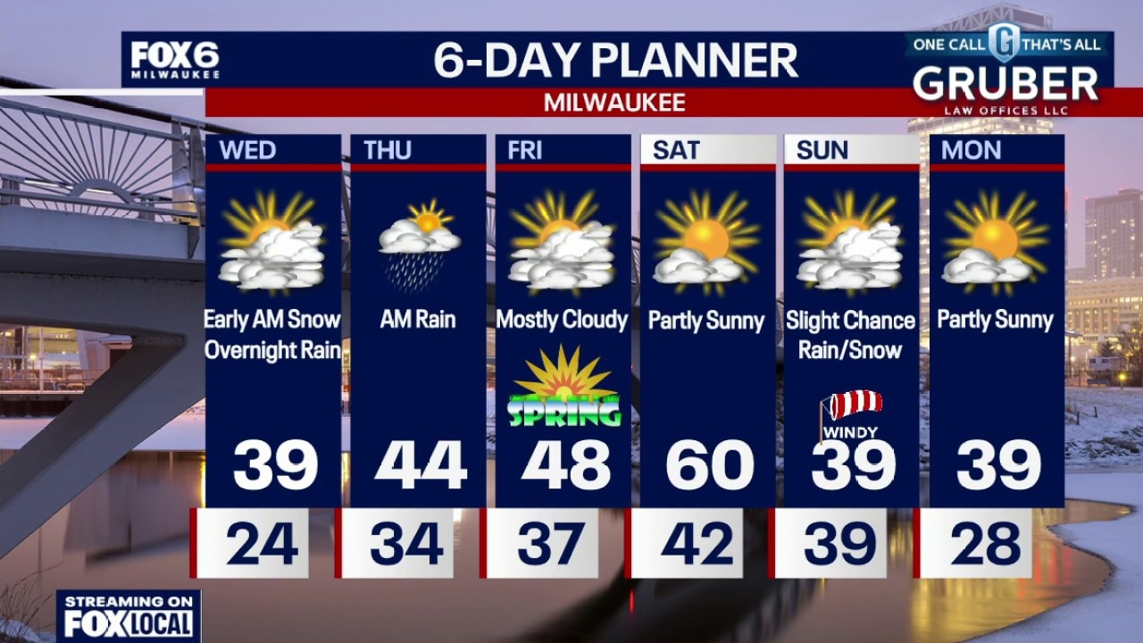
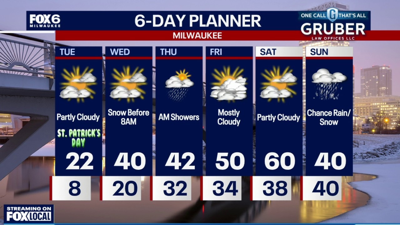
Light snow expected tonight through early Wednesday with up to 1" of accumulation possible. Light rain is then in the forecast Wednesday night through midday Thursday. Warming nicely Friday into Saturday then dropping temperatures Sunday with a chance of rain and snow showers.
Light snow expected tonight through early Wednesday with up to 1" of accumulation possible. Light rain is then in the forecast Wednesday night through midday Thursday. Warming nicely Friday into Saturday then dropping temperatures Sunday with a chance of rain and snow showers.
Weather Webcast with Stephanie Barichello
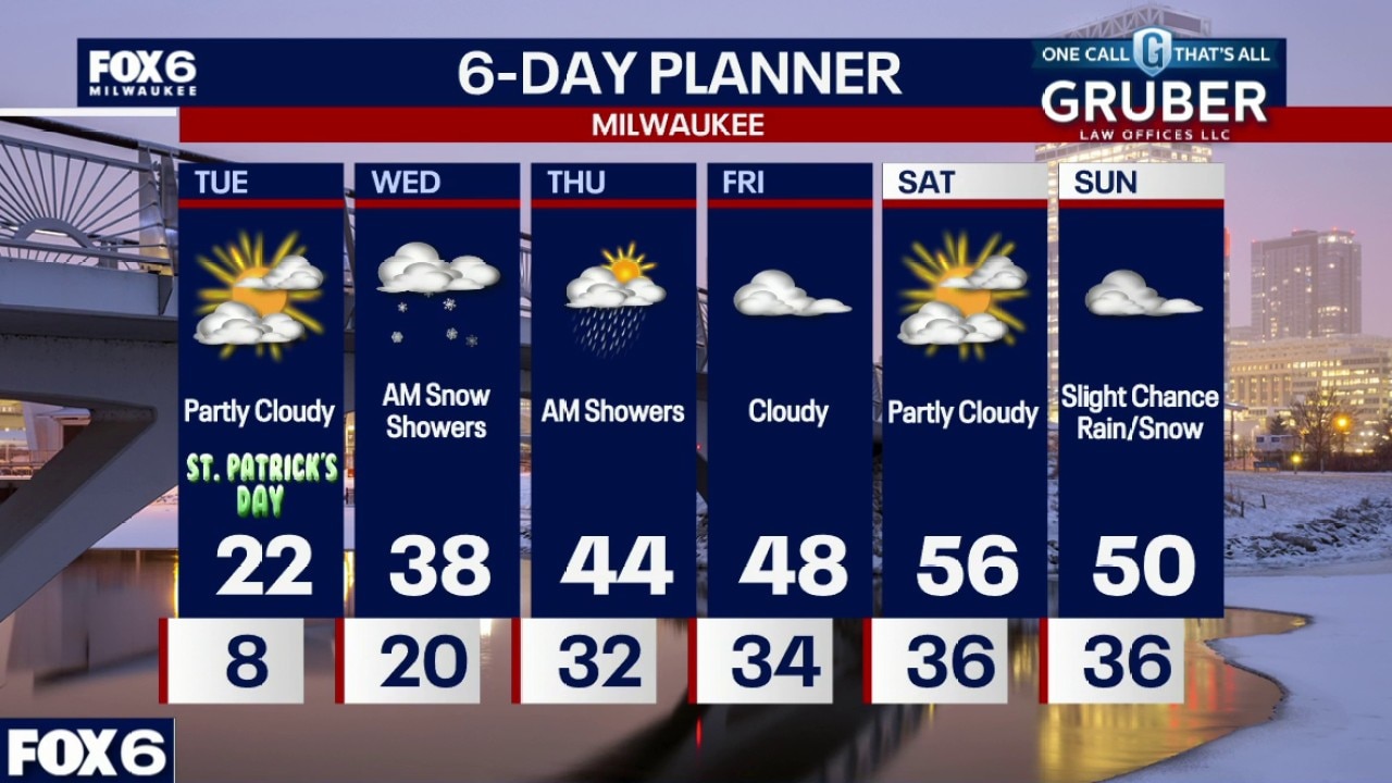
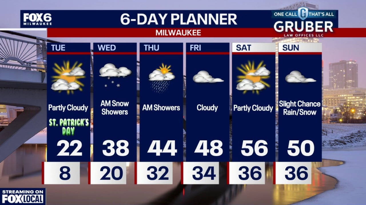
Light snow expected tonight through early Wednesday with up to 1" of accumulation possible. Light rain is then in the forecast Wednesday night through midday Thursday. Warming nicely Friday into Saturday then dropping temperatures Sunday with a chance of rain and snow showers.
Light snow expected tonight through early Wednesday with up to 1" of accumulation possible. Light rain is then in the forecast Wednesday night through midday Thursday. Warming nicely Friday into Saturday then dropping temperatures Sunday with a chance of rain and snow showers.
Weather webcast with Stephanie Barichello
A taste of the Arctic Tuesday morning with bitter cold and even colder wind chills, but the turnaround is already underway. Southerly winds kick in later Tuesday and begin a steady warmup that really takes hold by Wednesday.
A taste of the Arctic Tuesday morning with bitter cold and even colder wind chills, but the turnaround is already underway. Southerly winds kick in later Tuesday and begin a steady warmup that really takes hold by Wednesday.
Weather webcast with Rob Haswell
A taste of the Arctic Tuesday morning with bitter cold and even colder wind chills, but the turnaround is already underway. Southerly winds kick in later Tuesday and begin a steady warmup that really takes hold by Wednesday.
A taste of the Arctic Tuesday morning with bitter cold and even colder wind chills, but the turnaround is already underway. Southerly winds kick in later Tuesday and begin a steady warmup that really takes hold by Wednesday.
Weather Webcast with Chief Meteorologist Tom Wachs
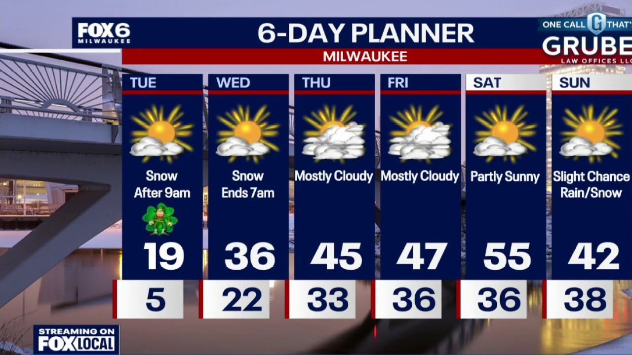
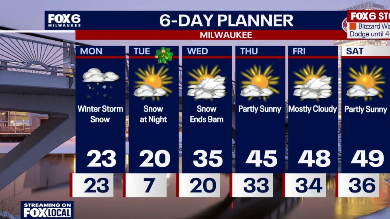
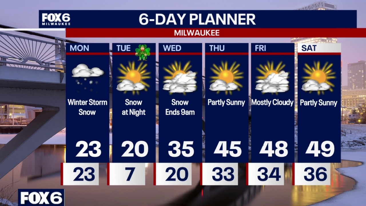
Clearing skies overnight and cold. Wind chills around -5 to -15 by morning. Partly sunny and cold on Tuesday with a high of 19. Snow moves in after 9pm Tuesday and moves out by 7am Wednesday. Around 1" of snow expected in Milwaukee, closer to 2" far inland. Warming up late week into Saturday.
Clearing skies overnight and cold. Wind chills around -5 to -15 by morning. Partly sunny and cold on Tuesday with a high of 19. Snow moves in after 9pm Tuesday and moves out by 7am Wednesday. Around 1" of snow expected in Milwaukee, closer to 2" far inland. Warming up late week into Saturday.
Weather Webcast with Chief Meteorologist Tom Wachs
Winter Weather Advisory until 9pm Tonight for all of SE WI. Snow is winding down, the wind will remain gusty tonight creating blowing ground snow. Skies will clear leading to a COLD night.
Winter Weather Advisory until 9pm Tonight for all of SE WI. Snow is winding down, the wind will remain gusty tonight creating blowing ground snow. Skies will clear leading to a COLD night.
Weather Webcast with Stephanie Barichello
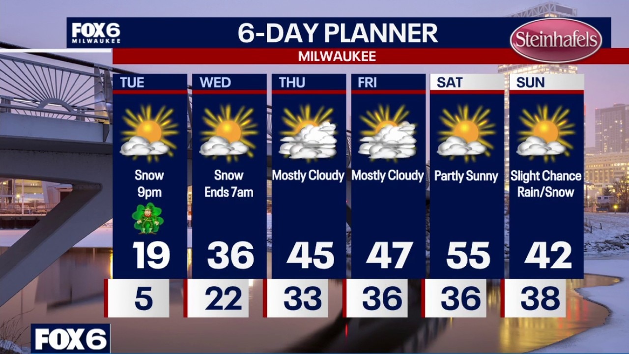
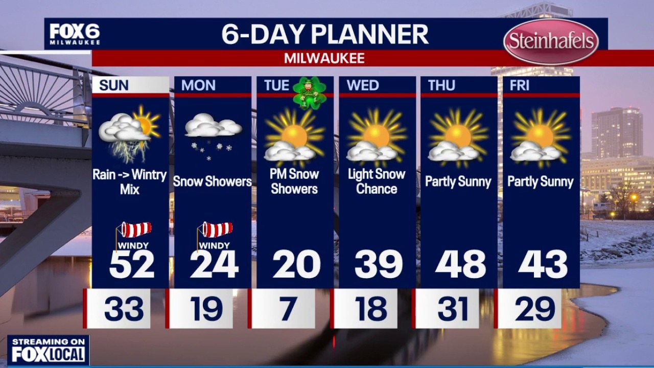
Snow is tapering off this evening but blowing snow will be a possibility through the night. Temperatures will drop into the single digits overnight with wind chills below 0. It's going to be a cold St. Patrick's Day! Another round of light snow expected Tuesday night with up to 1" of accumulation possible. Warming back to 50s late in the week.
Snow is tapering off this evening but blowing snow will be a possibility through the night. Temperatures will drop into the single digits overnight with wind chills below 0. It's going to be a cold St. Patrick's Day! Another round of light snow expected Tuesday night with up to 1" of accumulation possible. Warming back to 50s late in the week.
Weather webcast with Stephanie Barichello
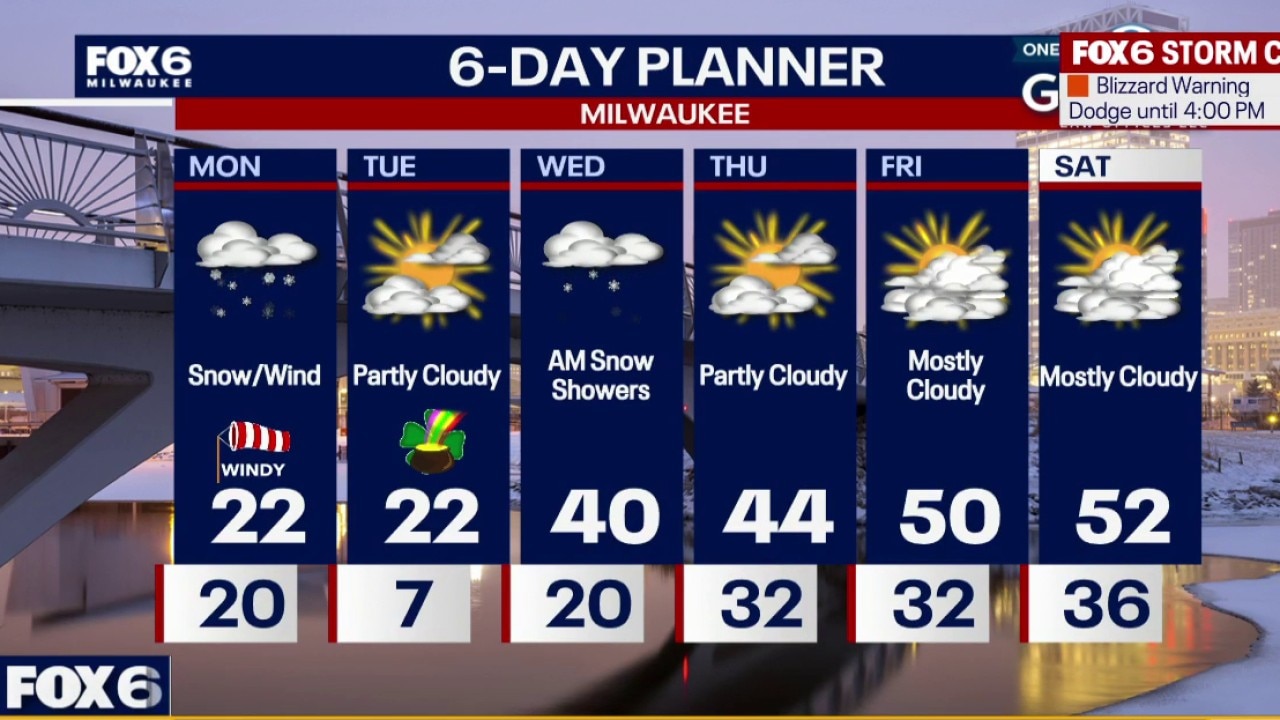
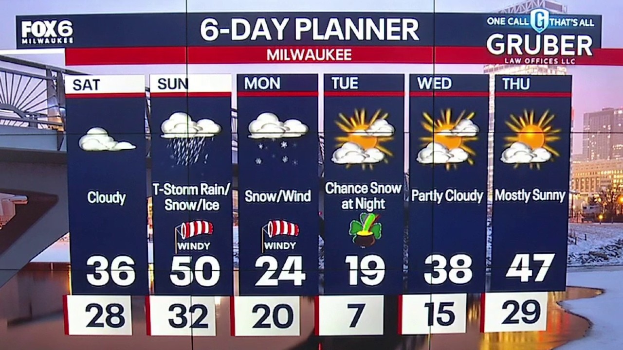
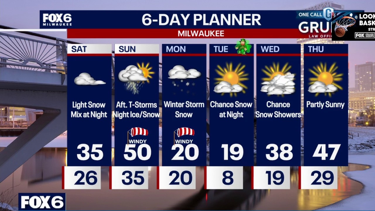
Blizzard warning until 4 p.m. A powerful late-season winter storm is hammering southern Wisconsin, producing blizzard conditions with heavy snowfall and wind gusts approaching 50-60 mph.
Blizzard warning until 4 p.m. A powerful late-season winter storm is hammering southern Wisconsin, producing blizzard conditions with heavy snowfall and wind gusts approaching 50-60 mph.
Weather webcast with Rob Haswell
A powerful late-season winter storm is hammering southern Wisconsin, producing blizzard conditions with heavy snowfall and wind gusts approaching 50-60 mph. Visibility will remain extremely limited through the morning commute before the snow gradually tapers from south to north late morning into midday. Even after the snow ends, gusty winds will keep blowing and drifting snow going.
A powerful late-season winter storm is hammering southern Wisconsin, producing blizzard conditions with heavy snowfall and wind gusts approaching 50-60 mph. Visibility will remain extremely limited through the morning commute before the snow gradually tapers from south to north late morning into midday. Even after the snow ends, gusty winds will keep blowing and drifting snow going.
Weather Webcast with Chief Meteorologist Tom Wachs
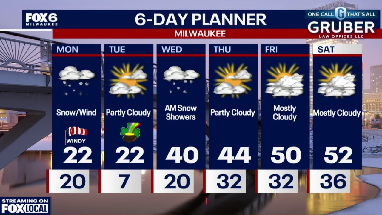
Blizzard Warning for ALL OF SE WI until 4pm Monday.
Blizzard Warning for ALL OF SE WI until 4pm Monday.
Weather Webcast with Chief Meteorologist Tom Wachs
Winter Storm Warning Jefferson, Washington, Ozaukee, Walworth, Waukesha, Fond du Lac and Sheboygan counties Tonight through 4pm Monday Winter Weather Advisory Milwaukee, Racine and Kenosha Co. Tonight through 4pm Monday
Winter Storm Warning Jefferson, Washington, Ozaukee, Walworth, Waukesha, Fond du Lac and Sheboygan counties Tonight through 4pm Monday Winter Weather Advisory Milwaukee, Racine and Kenosha Co. Tonight through 4pm Monday
Weather webcast with meteorologist Lisa Michaels
Areas south of WI-60 have a chance for scattered rain showers and afternoon thunderstorms. Areas north of WI-60 will see the wintry mix transition to rain with a possibility of freezing rain. Ice accumulations may occur, hence the Winter Weather Advisory still in effect until 4 p.m.
Areas south of WI-60 have a chance for scattered rain showers and afternoon thunderstorms. Areas north of WI-60 will see the wintry mix transition to rain with a possibility of freezing rain. Ice accumulations may occur, hence the Winter Weather Advisory still in effect until 4 p.m.
Weather Webcast with Holly Baker
We are tracking a winter storm for the weekend and the start of the week.
We are tracking a winter storm for the weekend and the start of the week.

Weather Webcast with Holly Baker
Tracking several chances of snow tonight into the weekend.
Tracking several chances of snow tonight into the weekend.
Weather Webcast with Holly Baker
Tracking several chances of snow tonight into the weekend.
Tracking several chances of snow tonight into the weekend.
Weather webcast with meteorologist Lisa Michaels
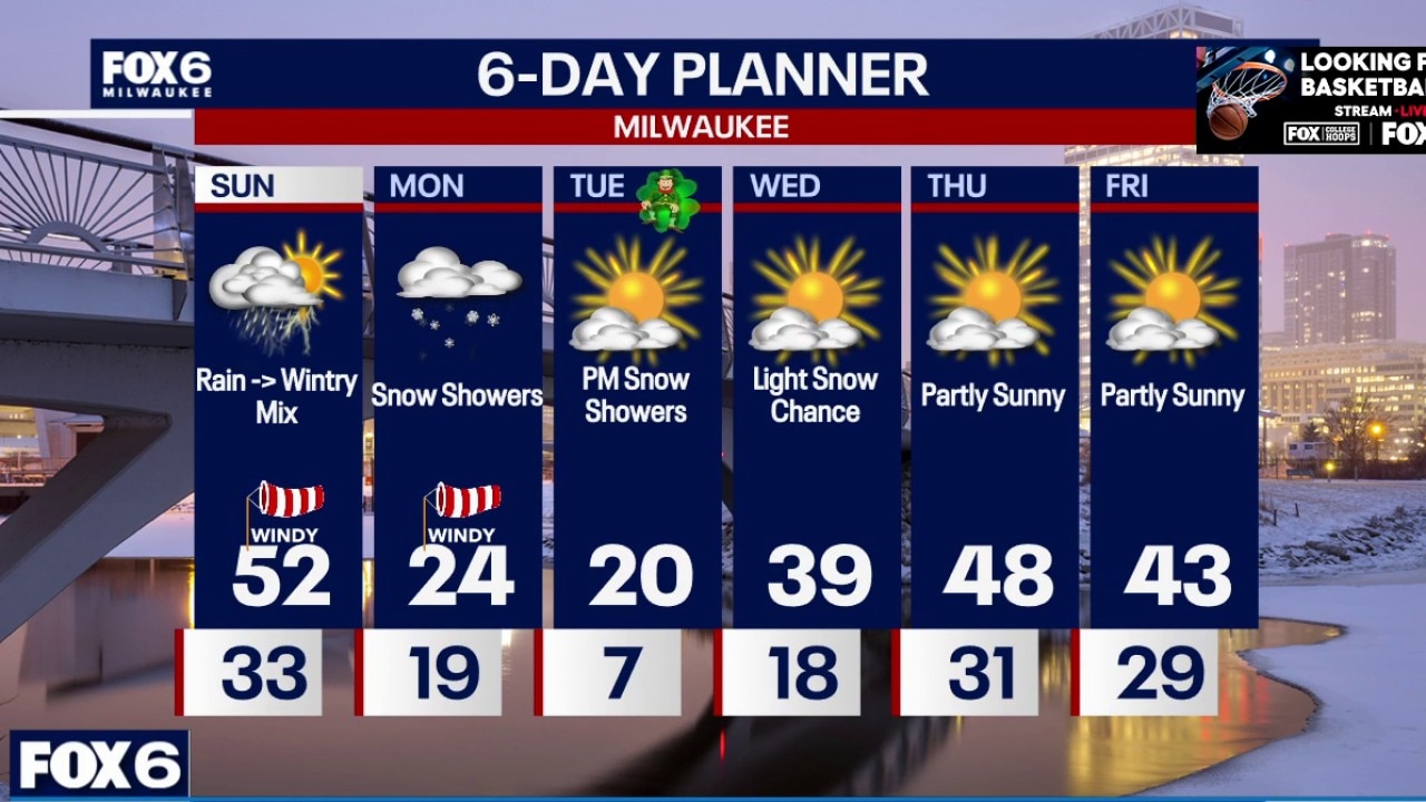
Increasing clouds (cloudy) Saturday with highs in the mid 30s. Chance of wintry mix in northern counties at night. Looking lower for most areas. Temps warm into Sunday with afternoon storms and snow by Monday.
Increasing clouds (cloudy) Saturday with highs in the mid 30s. Chance of wintry mix in northern counties at night. Looking lower for most areas. Temps warm into Sunday with afternoon storms and snow by Monday.
Weather Webcast with Chief Meteorologist Tom Wachs
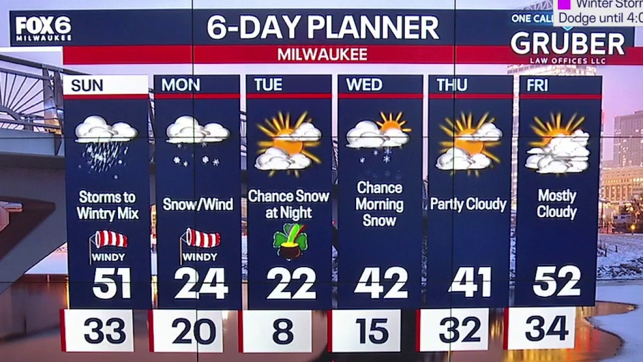
Phase 1: Winter Weather Advisory north of Milwaukee 7pm Sat. to 10am Sun. Phase 2: T-Storms on Sunday Afternoon with a high of 50. Phase 3: Winter Storm Watch ALL of SE WI 4pm Sunday to 7pm Monday
Phase 1: Winter Weather Advisory north of Milwaukee 7pm Sat. to 10am Sun. Phase 2: T-Storms on Sunday Afternoon with a high of 50. Phase 3: Winter Storm Watch ALL of SE WI 4pm Sunday to 7pm Monday