

Weather Webcast with Tom Wachs
Winter Storm Warning now until 12am for Milwaukee. Several inches of additional snow possible through 10pm. Slick roads and low visibility likely. Please use caution.
Winter Storm Warning now until 12am for Milwaukee. Several inches of additional snow possible through 10pm. Slick roads and low visibility likely. Please use caution.
Weather Webcast with Meteorologist Stephanie Barichello
Very messy weather continues this afternoon and evening with several inches of snow expected by later tonight. Sunshine returns tomorrow, then 40s over the weekend.
Very messy weather continues this afternoon and evening with several inches of snow expected by later tonight. Sunshine returns tomorrow, then 40s over the weekend.
Weather webcast with Rob Haswell
Winter Storm Warning for Milwaukee, Waukesha, Racine, Kenosha, Walworth, Ozaukee, & Washington Co. starting at 9am Winter Weather Advisory for Dodge, Fond du Lac and Sheboygan Co. starting at 9am Snow moves in after 6am and really picks up late morning. Snow will taper off this evening. 4-6" of snow in Milwaukee with locally higher amounts possible. A strong NE wind will also lead to blowing and drifting snow with poor visibility. Travel conditions will be very poor today.
Winter Storm Warning for Milwaukee, Waukesha, Racine, Kenosha, Walworth, Ozaukee, & Washington Co. starting at 9am Winter Weather Advisory for Dodge, Fond du Lac and Sheboygan Co. starting at 9am Snow moves in after 6am and really picks up late morning. Snow will taper off this evening. 4-6" of snow in Milwaukee with locally higher amounts possible. A strong NE wind will also lead to blowing and drifting snow with poor visibility. Travel conditions will be very poor today.
Weather Webcast with Tom Wachs
Snow moves in after 6am and continues all day. Low visibility likely with gusty winds as well. 4-6" in Milwaukee with locally higher amounts possible.
Snow moves in after 6am and continues all day. Low visibility likely with gusty winds as well. 4-6" in Milwaukee with locally higher amounts possible.
Weather Webcast with Tom Wachs
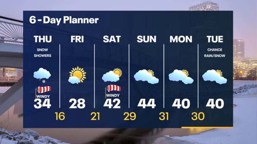
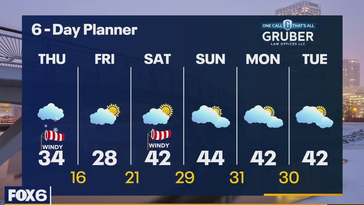
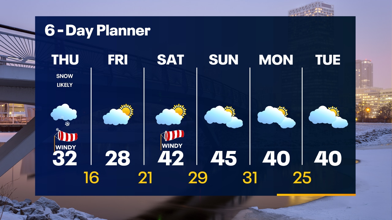
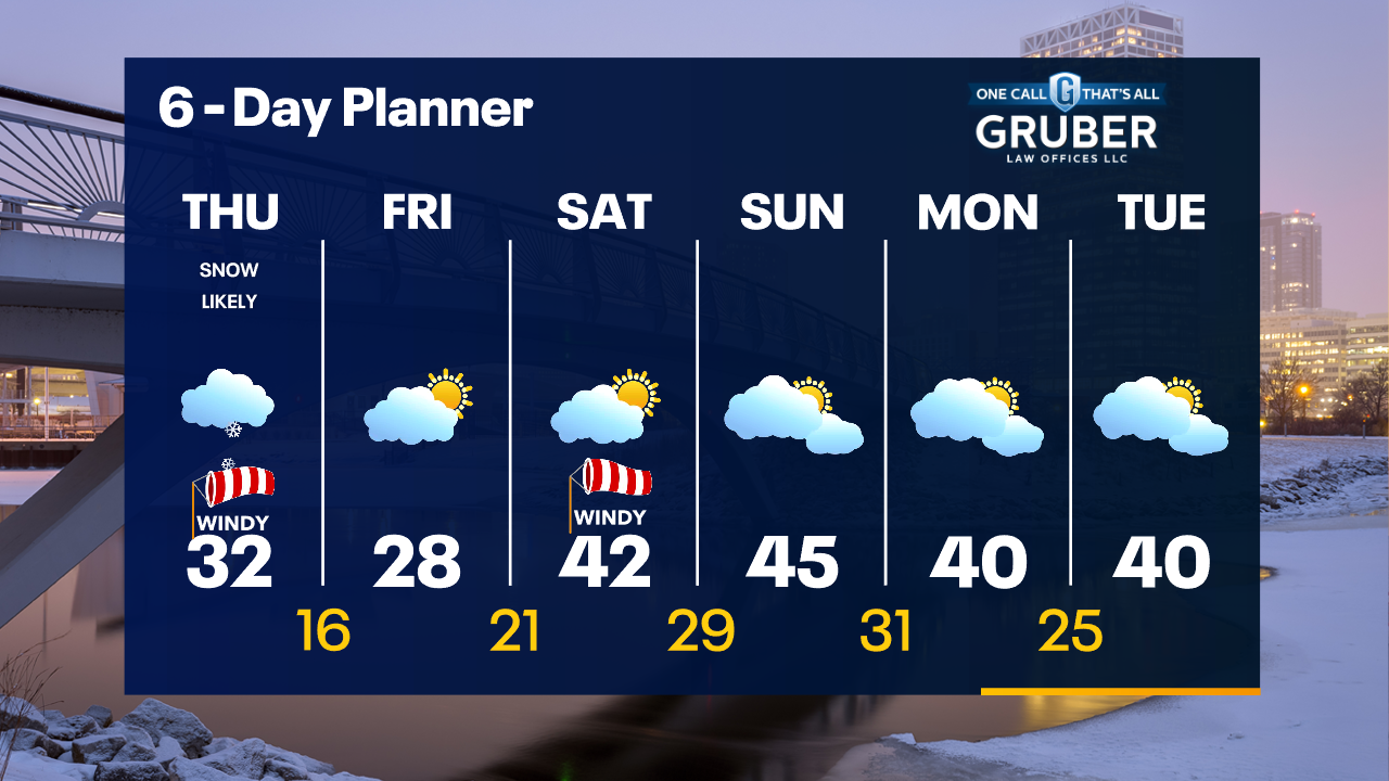
Winter Storm Warning for a large part of SE WI on Thursday. Snowy and windy. 4-6" of snow expected in Milwaukee on Thursday.
Winter Storm Warning for a large part of SE WI on Thursday. Snowy and windy. 4-6" of snow expected in Milwaukee on Thursday.
Weather Webcast with Meteorologist Stephanie Barichello
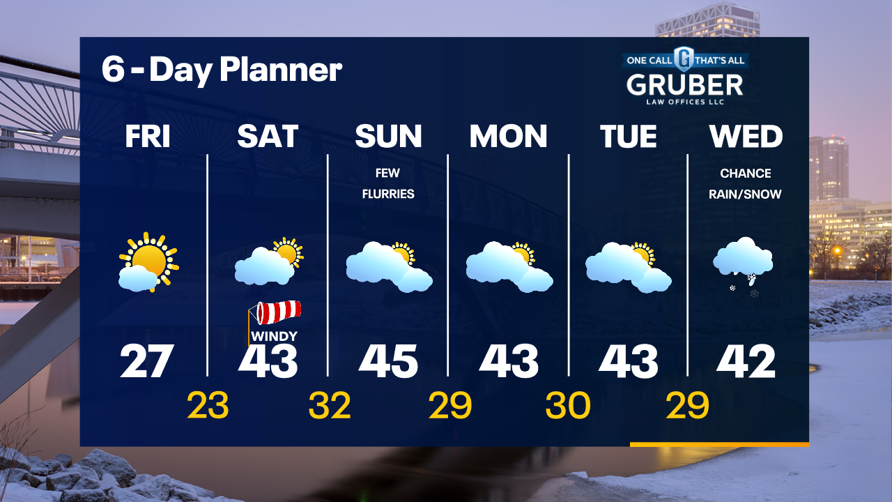
Windy this afternoon with temperatures in the 30s and 40s. Snow arrives Thursday morning and continues through early evening, especially across southern counties. Several inches of snow possible, especially if there is lake enhancement. Sunny but cold Friday.
Windy this afternoon with temperatures in the 30s and 40s. Snow arrives Thursday morning and continues through early evening, especially across southern counties. Several inches of snow possible, especially if there is lake enhancement. Sunny but cold Friday.

Weather webcast with Rob Haswell
A very mild morning ahead of a cold front. Temperatures will cool to the low to mid 40s this afternoon and fall into the upper 20s overnight. Wind speeds will ramp up today with strong gusts in excess of 40mph at times. A strong low passes to our south on Thursday with snow for our area. Some spots may see a lake enhancement with a strong NE wind all day. We clear up and cool down on Friday but bounce back into the 40s for the weekend.
A very mild morning ahead of a cold front. Temperatures will cool to the low to mid 40s this afternoon and fall into the upper 20s overnight. Wind speeds will ramp up today with strong gusts in excess of 40mph at times. A strong low passes to our south on Thursday with snow for our area. Some spots may see a lake enhancement with a strong NE wind all day. We clear up and cool down on Friday but bounce back into the 40s for the weekend.
Weather Webcast with Tom Wachs
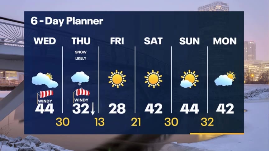
Rain ending overnight with temperatures in the 40s. It will stay windy on Wednesday with highs in the 40s. Snowy and windy on Thursday with several inches of snow.
Rain ending overnight with temperatures in the 40s. It will stay windy on Wednesday with highs in the 40s. Snowy and windy on Thursday with several inches of snow.
Weather Webcast with Tom Wachs
Rainy and windy tonight. Temperatures holding steady in the 40s. Rain tapers off overnight. Mostly cloudy and windy on Wednesday. Snowy on Thursday.
Rainy and windy tonight. Temperatures holding steady in the 40s. Rain tapers off overnight. Mostly cloudy and windy on Wednesday. Snowy on Thursday.
Weather Webcast with Meteorologist Stephanie Barichello
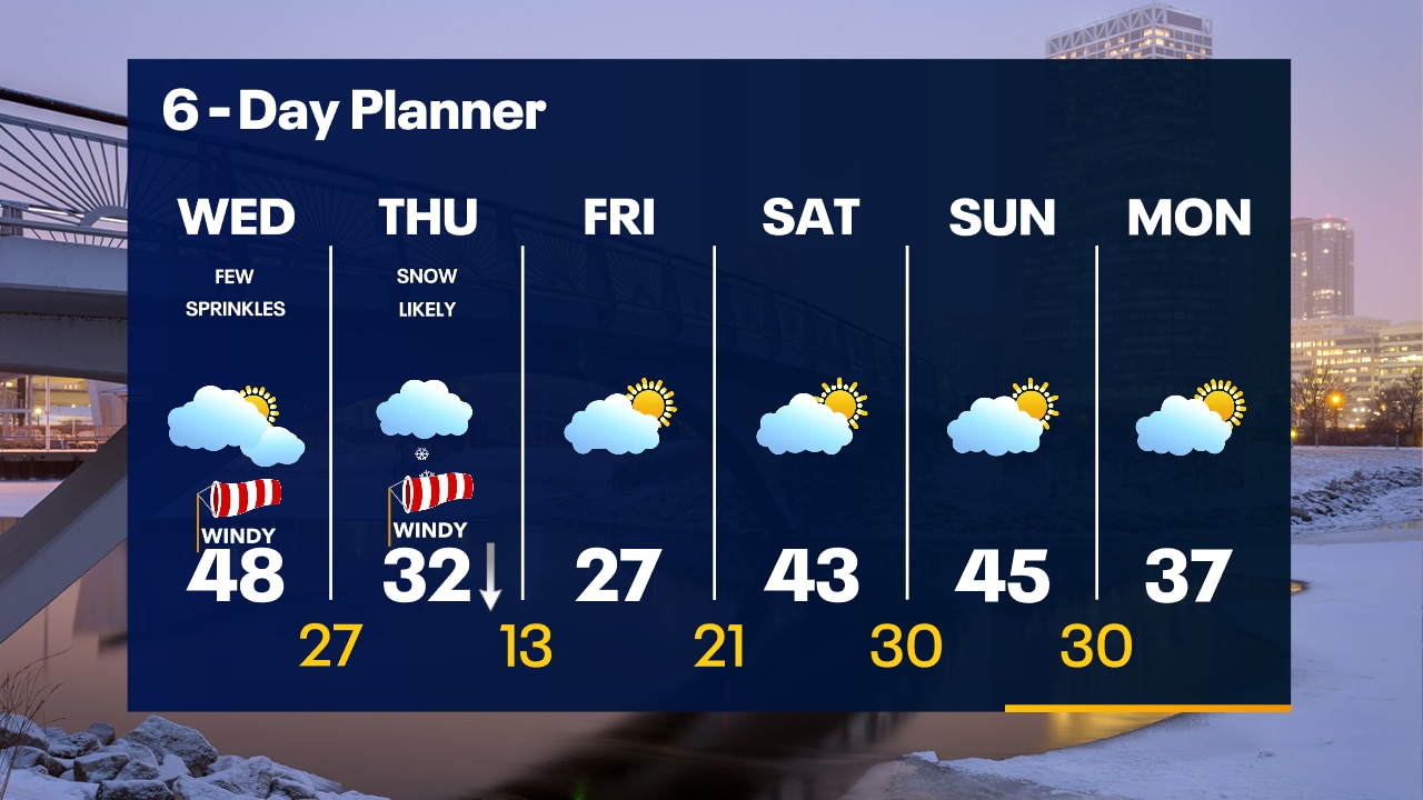
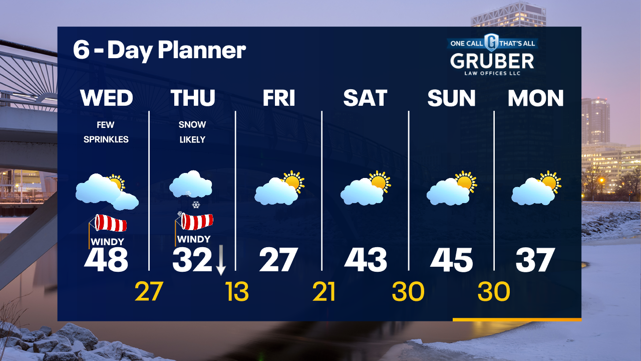
Rainy this afternoon and evening then windy on Wednesday. Accumulating snow is likely Thursday then expect a cold Friday. 40s though are back over the weekend.
Rainy this afternoon and evening then windy on Wednesday. Accumulating snow is likely Thursday then expect a cold Friday. 40s though are back over the weekend.
Weather webcast with Rob Haswell
Rain is on the way today as a system moves into our area this afternoon. We will also get windy with gusts this evening and overnight getting into the 30-35pmh range. Behind this system we cool a bit but remain well above average for Wednesday. We cool further by Thursday as another system moves our way. This next system will also whip up our wind and give us strong gusts in the 40+mph range. Snow is also expected with the Thursday system. It is far too early to give accurate forecasts for snow totals but there is a potential for several inches in some spots.
Rain is on the way today as a system moves into our area this afternoon. We will also get windy with gusts this evening and overnight getting into the 30-35pmh range. Behind this system we cool a bit but remain well above average for Wednesday. We cool further by Thursday as another system moves our way. This next system will also whip up our wind and give us strong gusts in the 40+mph range. Snow is also expected with the Thursday system. It is far too early to give accurate forecasts for snow totals but there is a potential for several inches in some spots.

Weather Webcast with Tom Wachs
Clear skies overnight with lows in the upper 20s to low 30s. Increasing clouds on Tuesday, windy with highs in the low 50s. Rain moves in after 3pm.
Clear skies overnight with lows in the upper 20s to low 30s. Increasing clouds on Tuesday, windy with highs in the low 50s. Rain moves in after 3pm.

Weather Webcast with Tom Wachs
Clear skies tonight with temperatures dropping through the 30s. The wind picks up on Tuesday with rain moving in by mid-afternoon. Rain continues Tuesday night.
Clear skies tonight with temperatures dropping through the 30s. The wind picks up on Tuesday with rain moving in by mid-afternoon. Rain continues Tuesday night.
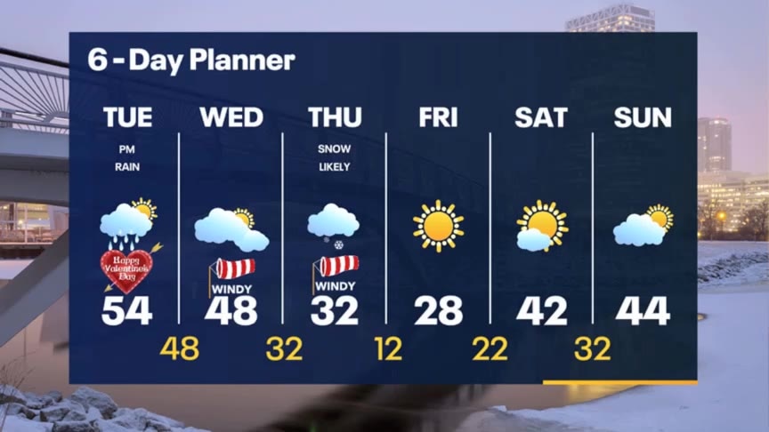
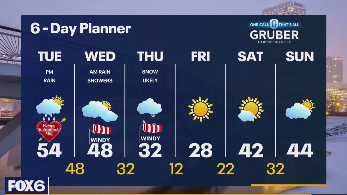
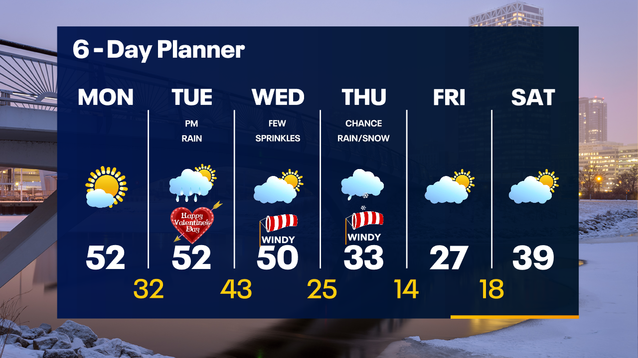
Weather Webcast with Meteorologist Stephanie Barichello
Sunny and mild again this afternoon then expect a soggy Valentine's afternoon and evening. Colder by the end of the week with a snow chance returning Thursday.
Sunny and mild again this afternoon then expect a soggy Valentine's afternoon and evening. Colder by the end of the week with a snow chance returning Thursday.
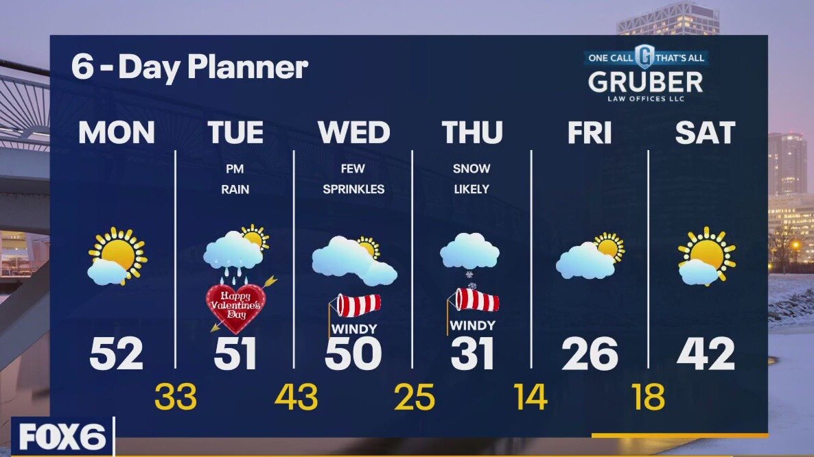
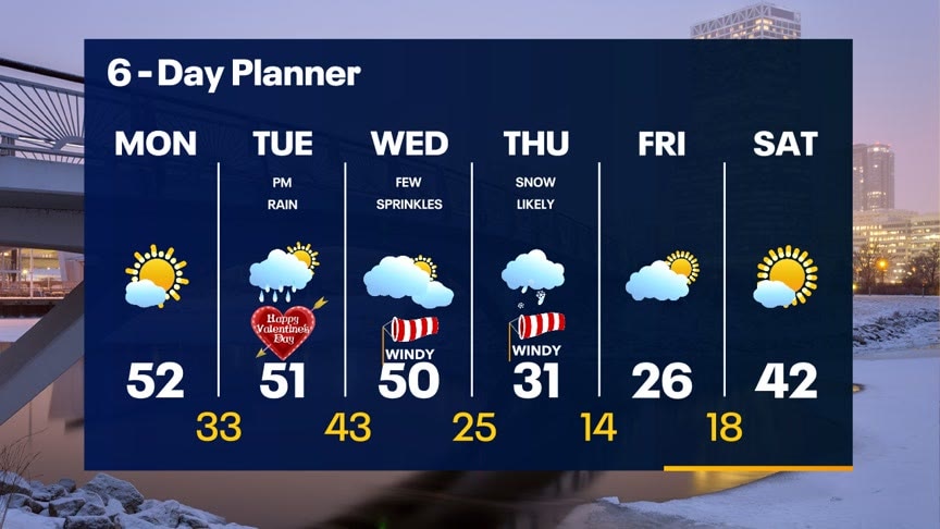
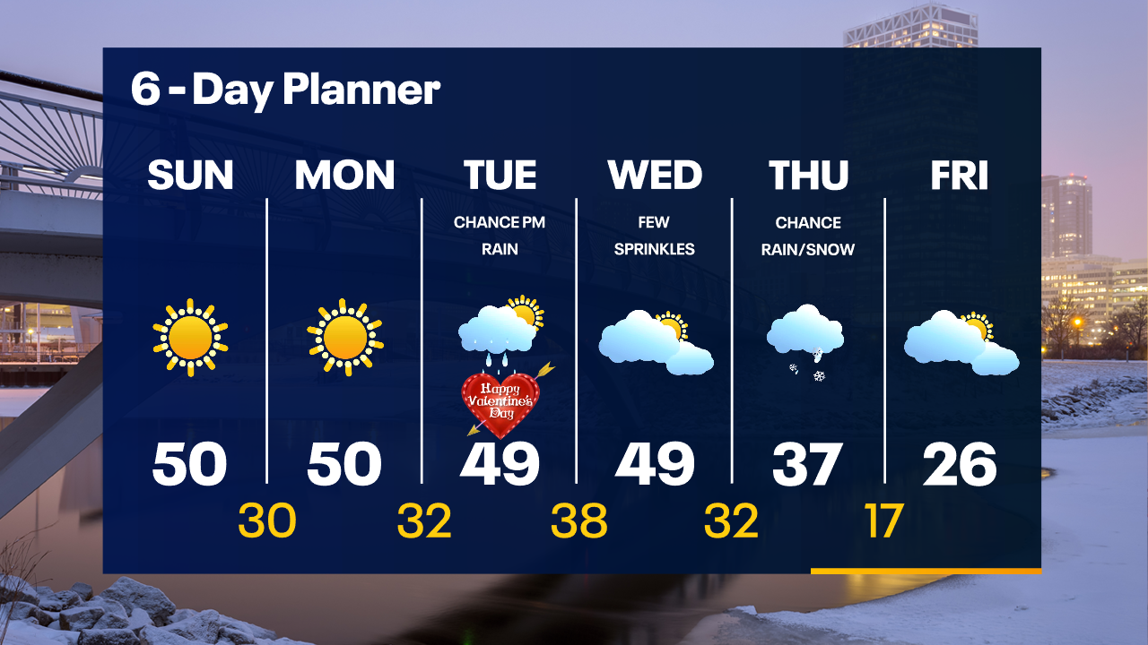
Weather webcast with Lisa Michaels
Temps in the low 30s and into the upper 20s to low 30s this morning. Another unseasonably warm day on Monday with sunny skies and highs in the upper 40s to low 50s. Rain returns Tuesday afternoon through early Wednesday morning. Mild temperatures & very windy through mid-week. A stronger storm system on Thursday will bring a chance mainly for snow.
Temps in the low 30s and into the upper 20s to low 30s this morning. Another unseasonably warm day on Monday with sunny skies and highs in the upper 40s to low 50s. Rain returns Tuesday afternoon through early Wednesday morning. Mild temperatures & very windy through mid-week. A stronger storm system on Thursday will bring a chance mainly for snow.
Weather Webcast with Tom Wachs
Mostly sunny and warm again on Monday. Highs in the upper 40s to low 50s. Our next storm system is on Tuesday afternoon and Tuesday night with a chance for rain.
Mostly sunny and warm again on Monday. Highs in the upper 40s to low 50s. Our next storm system is on Tuesday afternoon and Tuesday night with a chance for rain.

Weather Webcast with Tom Wachs
Mostly clear and mild tonight with temperatures falling through the 30s. Mostly sunny and unseasonably warm again on Monday with highs in the upper 40s to low 50s.
Mostly clear and mild tonight with temperatures falling through the 30s. Mostly sunny and unseasonably warm again on Monday with highs in the upper 40s to low 50s.

Weather Webcast with Meteorologist Lisa Michaels
Sunny Sunday with very mild temperatures reaching the upper 40s to low 50s this afternoon. More sunshine will begin the work week on Monday with temps in the upper 40s forecasted through Wednesday.
Sunny Sunday with very mild temperatures reaching the upper 40s to low 50s this afternoon. More sunshine will begin the work week on Monday with temps in the upper 40s forecasted through Wednesday.

Weather Webcast with Tom Wachs
Abundant sunshine on Sunday, not as windy with highs around 50. More mild weather on the way to start out the week as well.
Abundant sunshine on Sunday, not as windy with highs around 50. More mild weather on the way to start out the week as well.
Weather Webcast with Tom Wachs
Clear skies tonight with temperatures dropping through the 30s and into the 20s. More sun on the way Sunday with a high around 50.
Clear skies tonight with temperatures dropping through the 30s and into the 20s. More sun on the way Sunday with a high around 50.