

Weather webcast with Rob Haswell
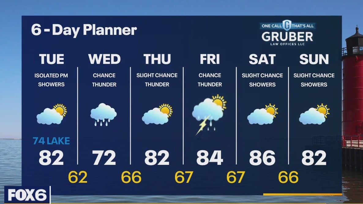
A few stray morning showers today then isolated afternoon showers and thunderstorms are possible - otherwise partly sunny and a bit cooler. Highs in the low 80s inland, upper 70s near the lake. Rain is likely Tuesday into Wednesday with a chance for thunderstorms. Wednesday's highs will be in the low 70s. Warm and humid late in the week into the weekend with highs in the 80s.
A few stray morning showers today then isolated afternoon showers and thunderstorms are possible - otherwise partly sunny and a bit cooler. Highs in the low 80s inland, upper 70s near the lake. Rain is likely Tuesday into Wednesday with a chance for thunderstorms. Wednesday's highs will be in the low 70s. Warm and humid late in the week into the weekend with highs in the 80s.
Weather Webcast with Tom Wachs
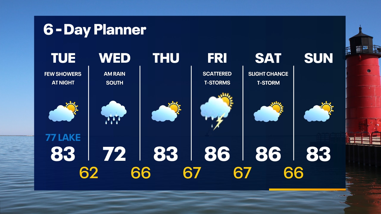
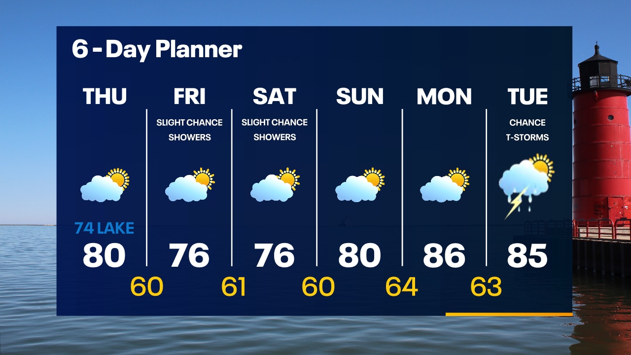
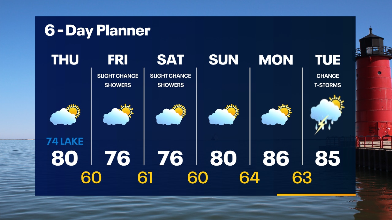
A few rain showers are possible overnight with temperatures in the upper 60s by sunrise. Partly sunny and cooler on Tuesday. Highs in the 70s near the lake, 80s inland. Rain is possible Tuesday night.
A few rain showers are possible overnight with temperatures in the upper 60s by sunrise. Partly sunny and cooler on Tuesday. Highs in the 70s near the lake, 80s inland. Rain is possible Tuesday night.

Weather Webcast with Tom Wachs
It was a hot Monday but a cool down is on the way. A few rain showers are possible overnight with temperatures dropping through the 70s. Partly sunny and cooler Tuesday with highs in the 70s near the lake, 80s inland.
It was a hot Monday but a cool down is on the way. A few rain showers are possible overnight with temperatures dropping through the 70s. Partly sunny and cooler Tuesday with highs in the 70s near the lake, 80s inland.
Weather webcast with Rob Haswell
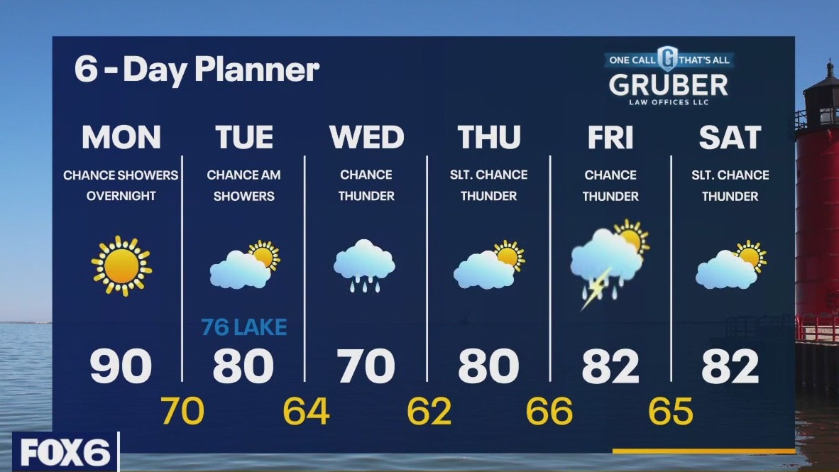
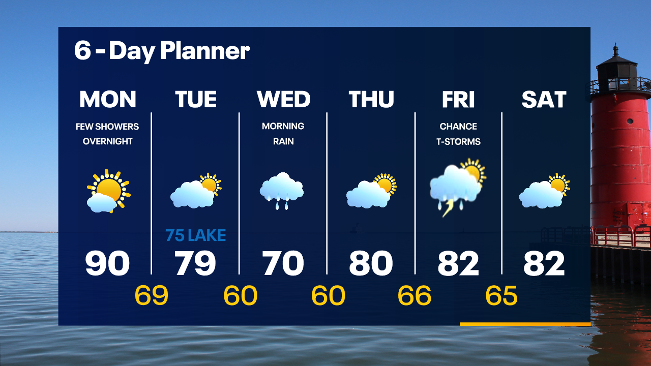
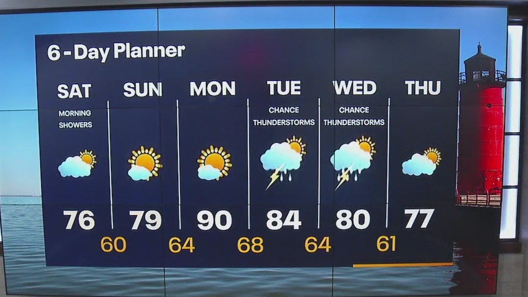
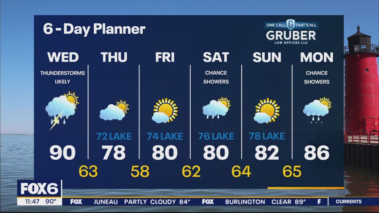
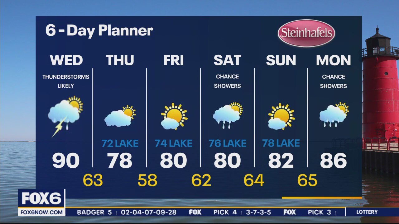
Hot and sunny today with highs near 90 and a breezy SW wind. A disturbance arrives overnight with a few showers and thunderstorms possible overnight into early Tuesday morning. Temperatures fall to the upper 70s and low 80s on Tuesday. Another disturbance will generate rain and thunderstorms through parts of Wednesday.
Hot and sunny today with highs near 90 and a breezy SW wind. A disturbance arrives overnight with a few showers and thunderstorms possible overnight into early Tuesday morning. Temperatures fall to the upper 70s and low 80s on Tuesday. Another disturbance will generate rain and thunderstorms through parts of Wednesday.
Weather Webcast with Tom Wachs
Mostly sunny, breezy and hot on Monday. High around 90. Monday will be the warmest day of the week.
Mostly sunny, breezy and hot on Monday. High around 90. Monday will be the warmest day of the week.

Weather Webcast with Tom Wachs
Clear and pleasant tonight with temperatures dropping into the 60s. Mostly sunny, breezy and hot on Monday with a high around 90.
Clear and pleasant tonight with temperatures dropping into the 60s. Mostly sunny, breezy and hot on Monday with a high around 90.

Weather Webcast with Meteorologist Lisa Michaels
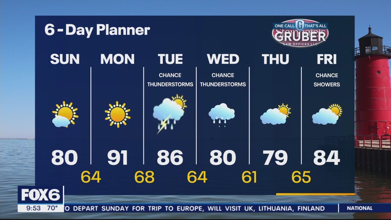
Fantastic to end the weekend with sunny skies and temps near 80 Sunday. Hot and muggy on Monday as highs rise to near 90. Few scattered rain chances Tuesday.
Fantastic to end the weekend with sunny skies and temps near 80 Sunday. Hot and muggy on Monday as highs rise to near 90. Few scattered rain chances Tuesday.
Weather Webcast with Meteorologist Eric Manges
Sunshine and warmer to start the week but storm chances return Tuesday and Wednesday
Sunshine and warmer to start the week but storm chances return Tuesday and Wednesday
Weather Webcast with Meteorologist Lisa Michaels
Morning showers as a low rides to the south of us. Rain should tapper off further into the day. Sun will arrive this afternoon with high temps in the mid 70s. Hot and humid weather returns on Monday.
Morning showers as a low rides to the south of us. Rain should tapper off further into the day. Sun will arrive this afternoon with high temps in the mid 70s. Hot and humid weather returns on Monday.
Weather Webcast with Meteorologist Eric Manges
Wetter than average trend heading into mid-July
Wetter than average trend heading into mid-July
Weather Webcast with Meteorologist Eric Manges
Happy Aphelion! What is that? Also rain chances heading into tonight and mid next week.
Happy Aphelion! What is that? Also rain chances heading into tonight and mid next week.
Weather webcast with Rob Haswell
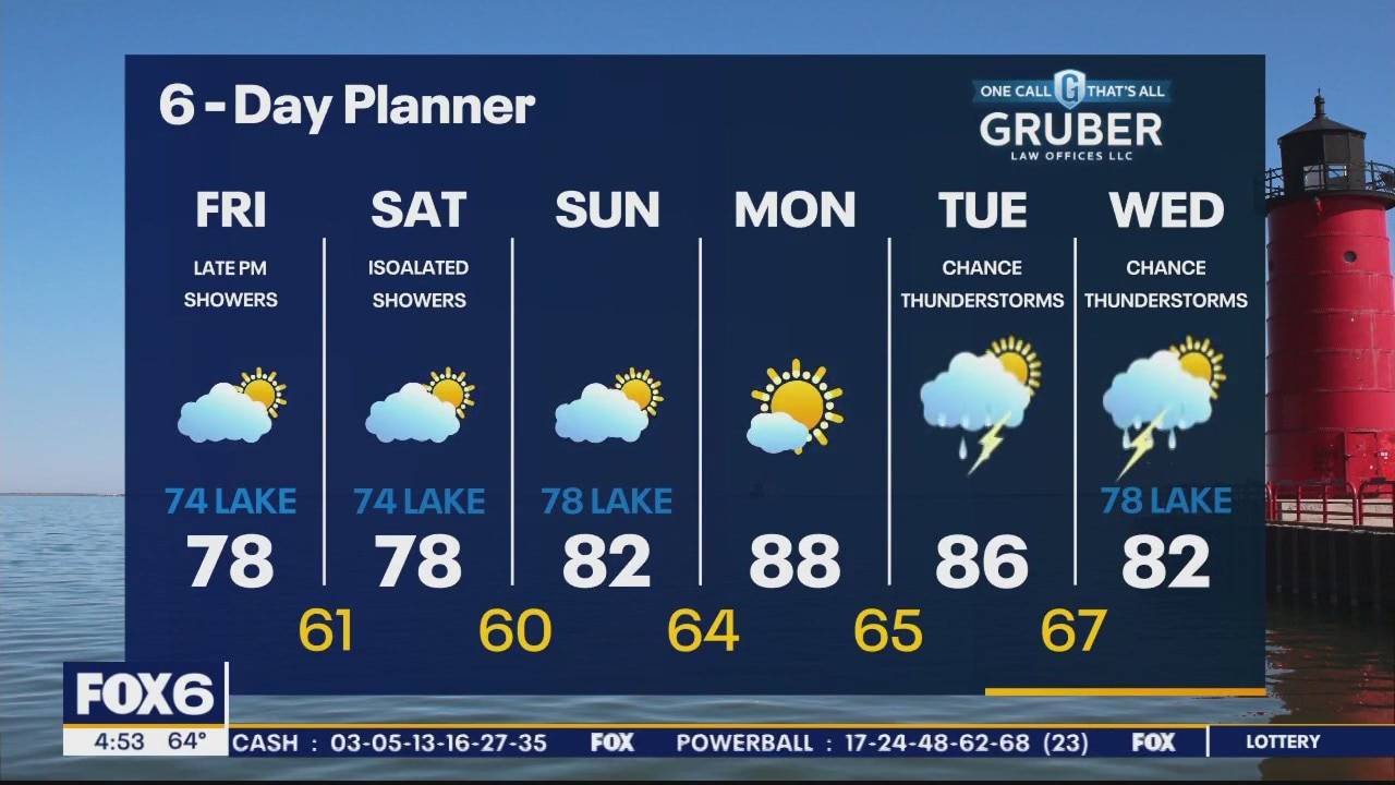
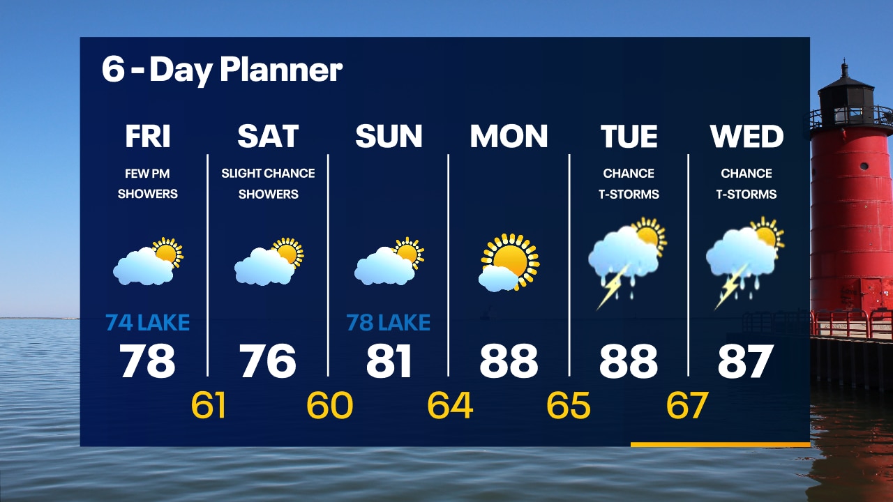
Sunny to start our Friday but increasingly cloudy later today with a chance for some overnight showers. Highs today will be similar to yesterday with upper 70s inland and low 70s lakeside. A few showers are possible on Saturday but we dry up and warm slightly for Sunday. We get hot and humid again early next week.
Sunny to start our Friday but increasingly cloudy later today with a chance for some overnight showers. Highs today will be similar to yesterday with upper 70s inland and low 70s lakeside. A few showers are possible on Saturday but we dry up and warm slightly for Sunday. We get hot and humid again early next week.
Weather Webcast with Tom Wachs
Clear skies overnight with temperatures falling into the 50s. Morning sun and afternoon clouds on Friday with highs in the 70s. A few showers are possible Friday night.
Clear skies overnight with temperatures falling into the 50s. Morning sun and afternoon clouds on Friday with highs in the 70s. A few showers are possible Friday night.

Weather Webcast with Tom Wachs
Clear skies tonight with temperatures dropping through the 60s and into the 50s overnight. Morning sun, afternoon clouds on Friday. A few late day rain showers possible with highs in the 70s.
Clear skies tonight with temperatures dropping through the 60s and into the 50s overnight. Morning sun, afternoon clouds on Friday. A few late day rain showers possible with highs in the 70s.
Weather Webcast with Meteorologist Eric Manges
Cooler to end the week then a chance of rain comes Saturday
Cooler to end the week then a chance of rain comes Saturday
Weather webcast with Rob Haswell
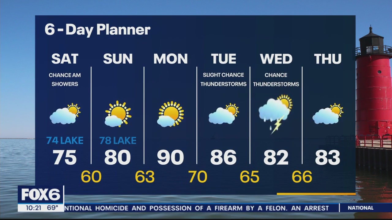
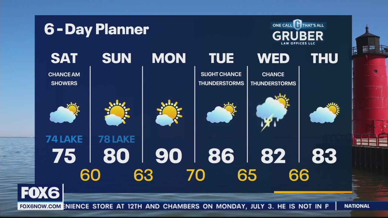
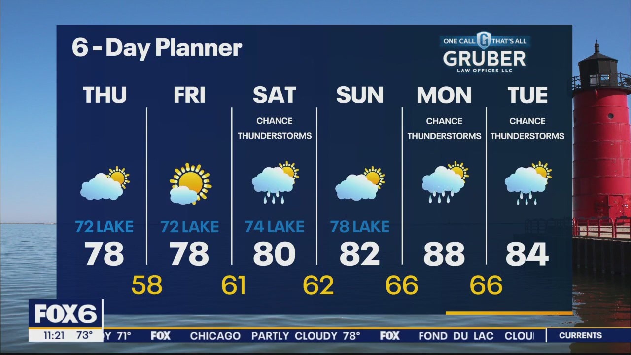
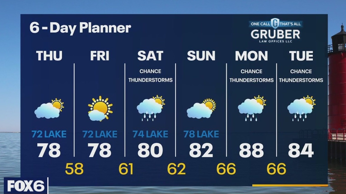
A cloudy start to our day but we should clear up a bit this afternoon. Temperatures and dewpoints will be much cooler behind yesterday's cold front. We stay cooler and less humid Friday. By overnight Friday into Saturday, we may see another round of showers and possible thunderstorms. We warm back into the 80s for the weekend. A bigger warm up arrives early next week with highs in the mid to upper 80s returning.
A cloudy start to our day but we should clear up a bit this afternoon. Temperatures and dewpoints will be much cooler behind yesterday's cold front. We stay cooler and less humid Friday. By overnight Friday into Saturday, we may see another round of showers and possible thunderstorms. We warm back into the 80s for the weekend. A bigger warm up arrives early next week with highs in the mid to upper 80s returning.
Weather Webcast with Tom Wachs
Humid overnight with temperatures in the 60s. Gradual clearing on Thursday with a drop in humidity levels by afternoon. Highs in the 70s near the lake, around 80 inland.
Humid overnight with temperatures in the 60s. Gradual clearing on Thursday with a drop in humidity levels by afternoon. Highs in the 70s near the lake, around 80 inland.
Weather Webcast with Tom Wachs
Showers and t-storms ending this evening. Staying humid with temperatures dropping into the 60s. Gradual clearing and dropping humidity levels Thursday. Highs in the 70s to around 80.
Showers and t-storms ending this evening. Staying humid with temperatures dropping into the 60s. Gradual clearing and dropping humidity levels Thursday. Highs in the 70s to around 80.
Weather webcast with Eric Manges
Ahead of a cold front for most of the day, we warm into the upper 80s and low 90s with high dewpoints making it feel hotter.
Ahead of a cold front for most of the day, we warm into the upper 80s and low 90s with high dewpoints making it feel hotter.
Weather webcast with Rob Haswell
Ahead of a cold front for most of the day, we warm into the upper 80s and low 90s with high dewpoints making it feel hotter. As the front moves through, we can expect rain and thunderstorms.
Ahead of a cold front for most of the day, we warm into the upper 80s and low 90s with high dewpoints making it feel hotter. As the front moves through, we can expect rain and thunderstorms.