

Weather webcast with Rob Haswell
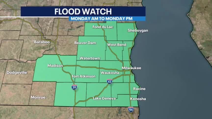
Flood Watch for all of SE WI from 7am this morning through 11pm tonight. Heavy rain at times today along with a risk for thunderstorms. Flash flooding in urban areas is possible. A very strong NE wind will gust in excess of 30mph at times and that will create potentially dangerous conditions on Lake Michigan with a Beach Hazards Statement in place. We dry up by mid-morning Tuesday and then heat up by the weekend.
Flood Watch for all of SE WI from 7am this morning through 11pm tonight. Heavy rain at times today along with a risk for thunderstorms. Flash flooding in urban areas is possible. A very strong NE wind will gust in excess of 30mph at times and that will create potentially dangerous conditions on Lake Michigan with a Beach Hazards Statement in place. We dry up by mid-morning Tuesday and then heat up by the weekend.

Weather Webcast with Tom Wachs
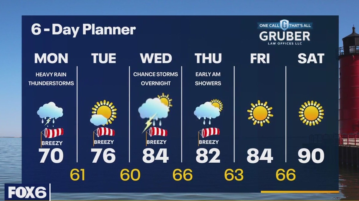
Flood Watch on Monday for all of SE WI. Heavy rain really picks up mid-to-late morning and continue through Monday night. In excess of 1-3" of rain possible in some areas.
Flood Watch on Monday for all of SE WI. Heavy rain really picks up mid-to-late morning and continue through Monday night. In excess of 1-3" of rain possible in some areas.
Weather Webcast with Tom Wachs
Off-and-on light rain showers tonight. Temperatures in the 60s. Flood Watch on Monday with heavy rain likely. It will rain all day and all evening Monday. Several inches of rain likely.
Off-and-on light rain showers tonight. Temperatures in the 60s. Flood Watch on Monday with heavy rain likely. It will rain all day and all evening Monday. Several inches of rain likely.
Weather Webcast with Meteorologist Lisa Michaels
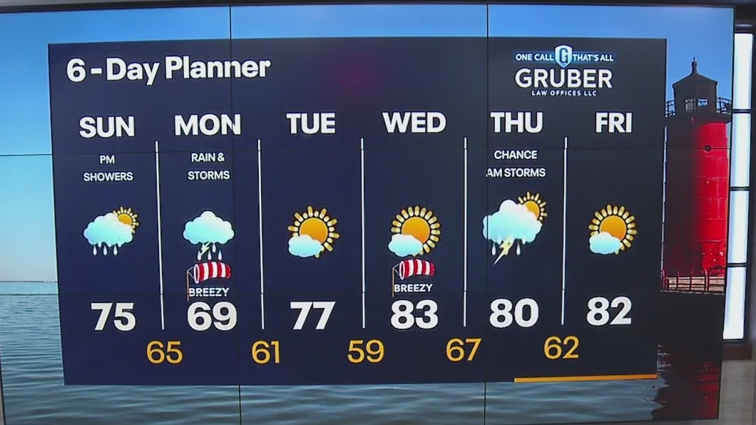
Slowly increasing clouds for Sunday then late Sunday night into Monday morning our next chance of rain moves in. Rain and storms will be persistent through Monday. Accumulation could be 1"+ for areas. Cooler conditions to start the week but we warm back up into the 80s by midweek.
Slowly increasing clouds for Sunday then late Sunday night into Monday morning our next chance of rain moves in. Rain and storms will be persistent through Monday. Accumulation could be 1"+ for areas. Cooler conditions to start the week but we warm back up into the 80s by midweek.

Weather Webcast with Meteorologist Eric Manges
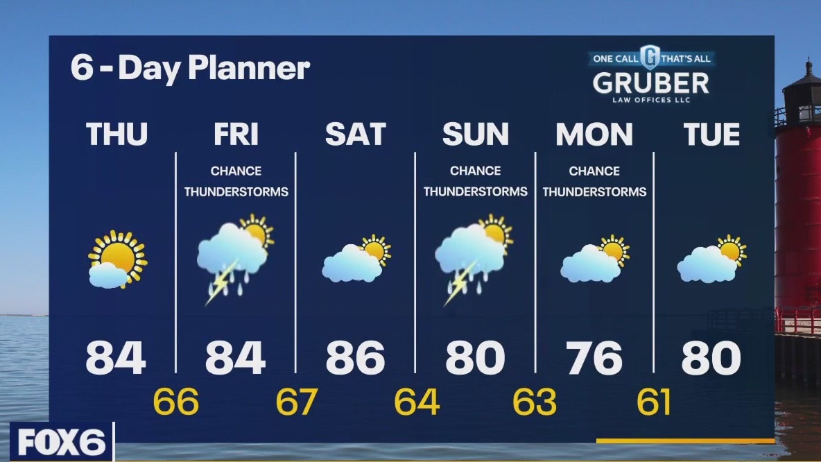
Widespread rain likely on Monday with more rain chances come Thursday
Widespread rain likely on Monday with more rain chances come Thursday

Weather Webcast with Meteorologist Eric Manges
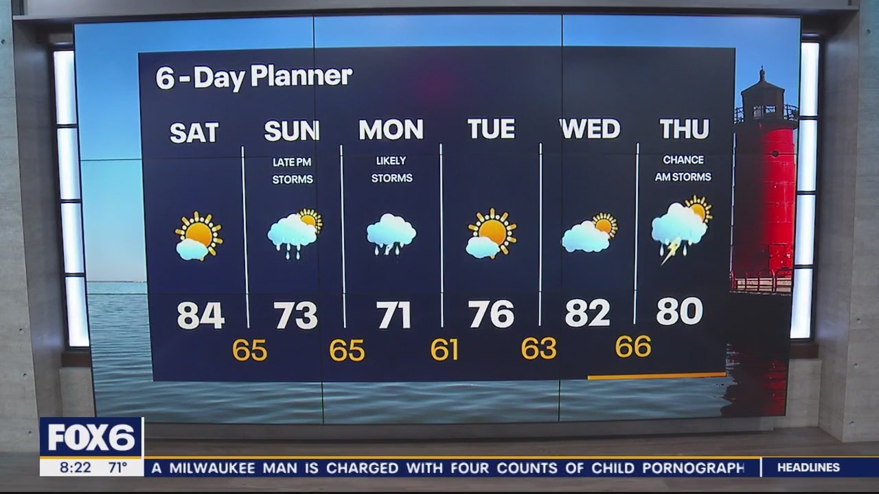
Great rain potential Sunday night into Monday, should be a good soak for most.
Great rain potential Sunday night into Monday, should be a good soak for most.
Weather Webcast with Meteorologist Lisa Michaels
Lingering light morning rain. Most areas will clear clouds out early. Highs in the low to mid 80s under mostly sunny skies Saturday. Even cooler Sunday with highs in the low 70s.
Lingering light morning rain. Most areas will clear clouds out early. Highs in the low to mid 80s under mostly sunny skies Saturday. Even cooler Sunday with highs in the low 70s.

Weather Webcast with Meteorologist Eric Manges
Gusty storms tonight give way to perfect weather for Saturday
Gusty storms tonight give way to perfect weather for Saturday
Weather Webcast with Meteorologist Eric Manges
Strong storms possible into tonight but then decent weather for the weekend
Strong storms possible into tonight but then decent weather for the weekend

Weather Webcast With Lisa Michaels
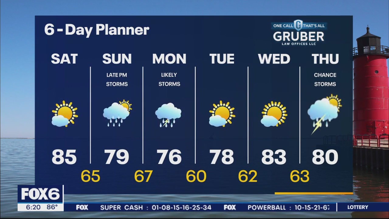
Clouds clearing today will help destabilize the atmosphere. Highs push into the mid-80s and humid. Another round or two of storms in possible this afternoon and tonight. There remains a Slight Risk for severe storms in our area today. The weekend is looking good for most outdoor activities. Cooling into the upper 70s/low 80s by Sunday. Rain returns very late Sunday through Monday.
Clouds clearing today will help destabilize the atmosphere. Highs push into the mid-80s and humid. Another round or two of storms in possible this afternoon and tonight. There remains a Slight Risk for severe storms in our area today. The weekend is looking good for most outdoor activities. Cooling into the upper 70s/low 80s by Sunday. Rain returns very late Sunday through Monday.
Weather webcast with Rob Haswell
Tracking a complex of storms this morning that may bring an early round of rain and thunderstorms but it is weakening as it moves our way. Another round or two of storms in possible later today and tonight. There remains a Slight Risk for severe storms in our area today. Highs will reach the mid 80s today with high dewpoints making it feel warming. The strong wind from the SW will be in the 10-20mph range most of the day. The weekend is looking good for most outdoor activities with rain returning late Sunday.
Tracking a complex of storms this morning that may bring an early round of rain and thunderstorms but it is weakening as it moves our way. Another round or two of storms in possible later today and tonight. There remains a Slight Risk for severe storms in our area today. Highs will reach the mid 80s today with high dewpoints making it feel warming. The strong wind from the SW will be in the 10-20mph range most of the day. The weekend is looking good for most outdoor activities with rain returning late Sunday.

Weather Webcast with Tom Wachs
Chance for rain 8am-Noon Friday. Dry and warm Friday afternoon with highs in the mid-80s. Chance for strong storms after 8pm Friday.
Chance for rain 8am-Noon Friday. Dry and warm Friday afternoon with highs in the mid-80s. Chance for strong storms after 8pm Friday.
Weather Webcast with Tom Wachs
Increasing clouds tonight with temperatures dropping into the 60s. Morning rain between 8am-Noon followed by some afternoon sun. Strong storms possible after 8pm Friday.
Increasing clouds tonight with temperatures dropping into the 60s. Morning rain between 8am-Noon followed by some afternoon sun. Strong storms possible after 8pm Friday.

Weather Webcast with Meteorologist Eric Manges
Storm chances return Friday with a chance for stronger storms too
Storm chances return Friday with a chance for stronger storms too
Weather webcast with Rob Haswell
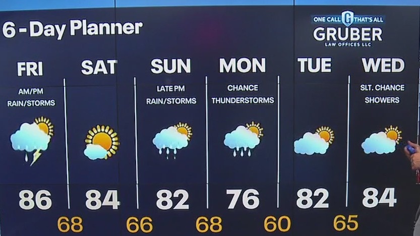
A wind shift to the NW today with the passage of a weak cold front today. Highs won't change much from yesterday and will remain in the low 80s with ample sun. A warm front and its associated low will arrive Friday with rain and a chance for thunderstorms. There is a Slight Risk for severe storms on Friday. We should calm and clear for Saturday but remain returns by later in the day on Sunday. Cooler air arrives early next week.
A wind shift to the NW today with the passage of a weak cold front today. Highs won't change much from yesterday and will remain in the low 80s with ample sun. A warm front and its associated low will arrive Friday with rain and a chance for thunderstorms. There is a Slight Risk for severe storms on Friday. We should calm and clear for Saturday but remain returns by later in the day on Sunday. Cooler air arrives early next week.
Weather Webcast with Tom Wachs
Partly cloudy overnight with temperatures dropping into the 60s. Partly sunny and warm on Thursday with highs in the mid-80s. Scattered t-storm chances return Friday.
Partly cloudy overnight with temperatures dropping into the 60s. Partly sunny and warm on Thursday with highs in the mid-80s. Scattered t-storm chances return Friday.

Weather Webcast with Tom Wachs
T-Storms in Fond du Lac and Sheboygan counties will taper off this evening. Partly cloudy elsewhere with temperatures falling through the 70s. Partly sunny on Thursday with a high in the mid-80s.
T-Storms in Fond du Lac and Sheboygan counties will taper off this evening. Partly cloudy elsewhere with temperatures falling through the 70s. Partly sunny on Thursday with a high in the mid-80s.
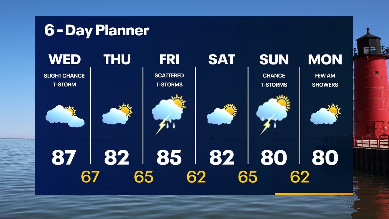
Weather Webcast with Meteorologist Eric Manges
Storm chances return both Friday and Sunday but until then warmer today
Storm chances return both Friday and Sunday but until then warmer today

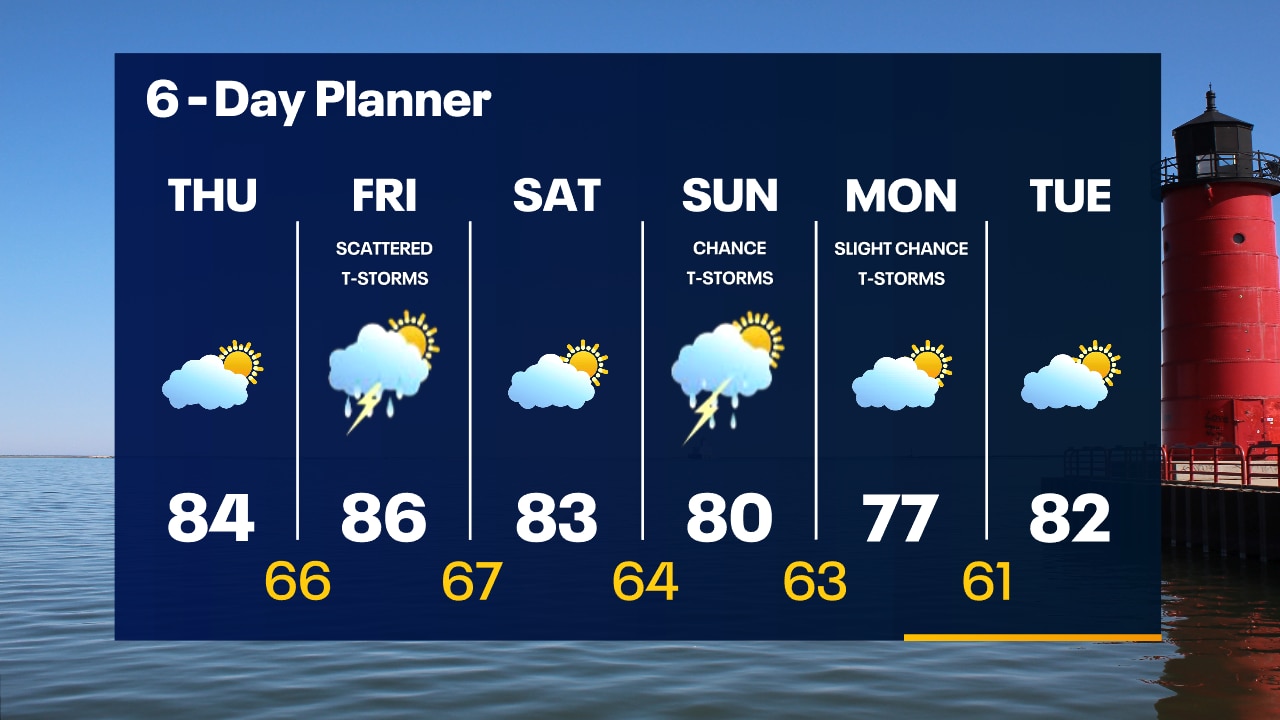
Weather webcast with Rob Haswell
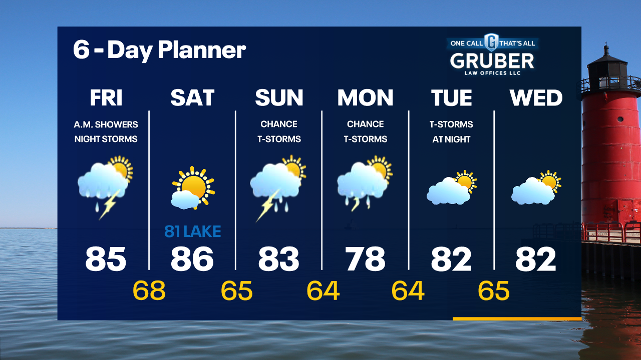
A low passes to our south as a cold front enters the region from the north today. We should slide between the two more active areas of precipitation with just a chance for a few showers today. Highs will get into the mid to upper 80s today but we will cool to the low 80s Thursday and into the weekend. Our next chance for showers arrives on Friday and again on Sunday.
A low passes to our south as a cold front enters the region from the north today. We should slide between the two more active areas of precipitation with just a chance for a few showers today. Highs will get into the mid to upper 80s today but we will cool to the low 80s Thursday and into the weekend. Our next chance for showers arrives on Friday and again on Sunday.
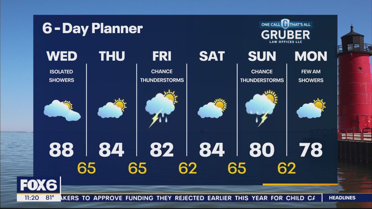
Weather Webcast with Tom Wachs
Mostly clear overnight with temperatures dropping through the 60s. Becoming mostly cloudy on Wednesday with only a slight chance for afternoon showers. Highs in the mid-to-upper 80s.
Mostly clear overnight with temperatures dropping through the 60s. Becoming mostly cloudy on Wednesday with only a slight chance for afternoon showers. Highs in the mid-to-upper 80s.