

Weather Webcast with Meteorologist Lisa Michaels
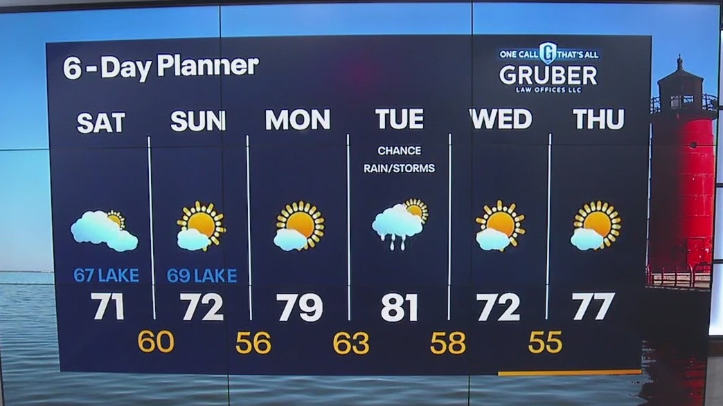
Fog in the morning. Mostly cloudy with northeasterly wind gusting 20-25mph. Clouds gradually clear later today. Beach Hazard Statement for Saturday: 3-6ft waves, dangerous currents, high swim risk Noticeably cooler for the weekend as highs struggle to reach the 70s.
Fog in the morning. Mostly cloudy with northeasterly wind gusting 20-25mph. Clouds gradually clear later today. Beach Hazard Statement for Saturday: 3-6ft waves, dangerous currents, high swim risk Noticeably cooler for the weekend as highs struggle to reach the 70s.

Weather Webcast with Meteorologist Eric Manges
Cooler air settles in for the weekend with a chance of rain early Tuesday morning
Cooler air settles in for the weekend with a chance of rain early Tuesday morning

Weather Webcast With Lisa Michaels
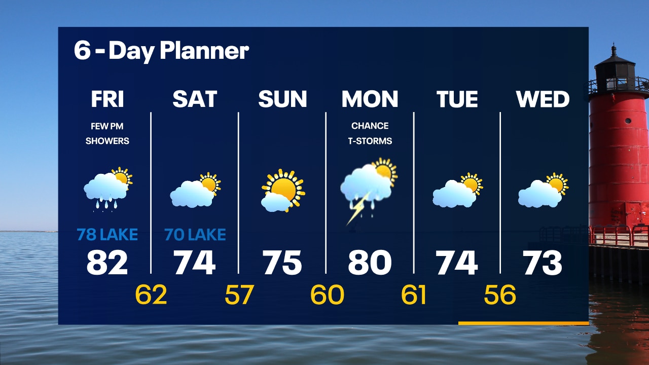
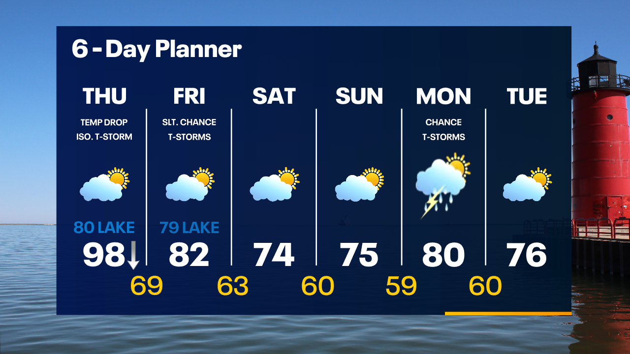
A few afternoon showers possible. Otherwise mostly cloudy. Highs will be in the low 80s inland and in the 70s lakeside with a NE-E wind all day. An isolated shower/storm possible tonight with the passing of a cold front. Temps in the mid 60s tonight. Highs will fall into the low and mid 70s this weekend behind that front but with high pressure returning, we get the sun back. Temperatures remain on the cooler side into the middle of next week. Chance of rain Monday/Tuesday.
A few afternoon showers possible. Otherwise mostly cloudy. Highs will be in the low 80s inland and in the 70s lakeside with a NE-E wind all day. An isolated shower/storm possible tonight with the passing of a cold front. Temps in the mid 60s tonight. Highs will fall into the low and mid 70s this weekend behind that front but with high pressure returning, we get the sun back. Temperatures remain on the cooler side into the middle of next week. Chance of rain Monday/Tuesday.

FOX6 WakeUp News at 4:30
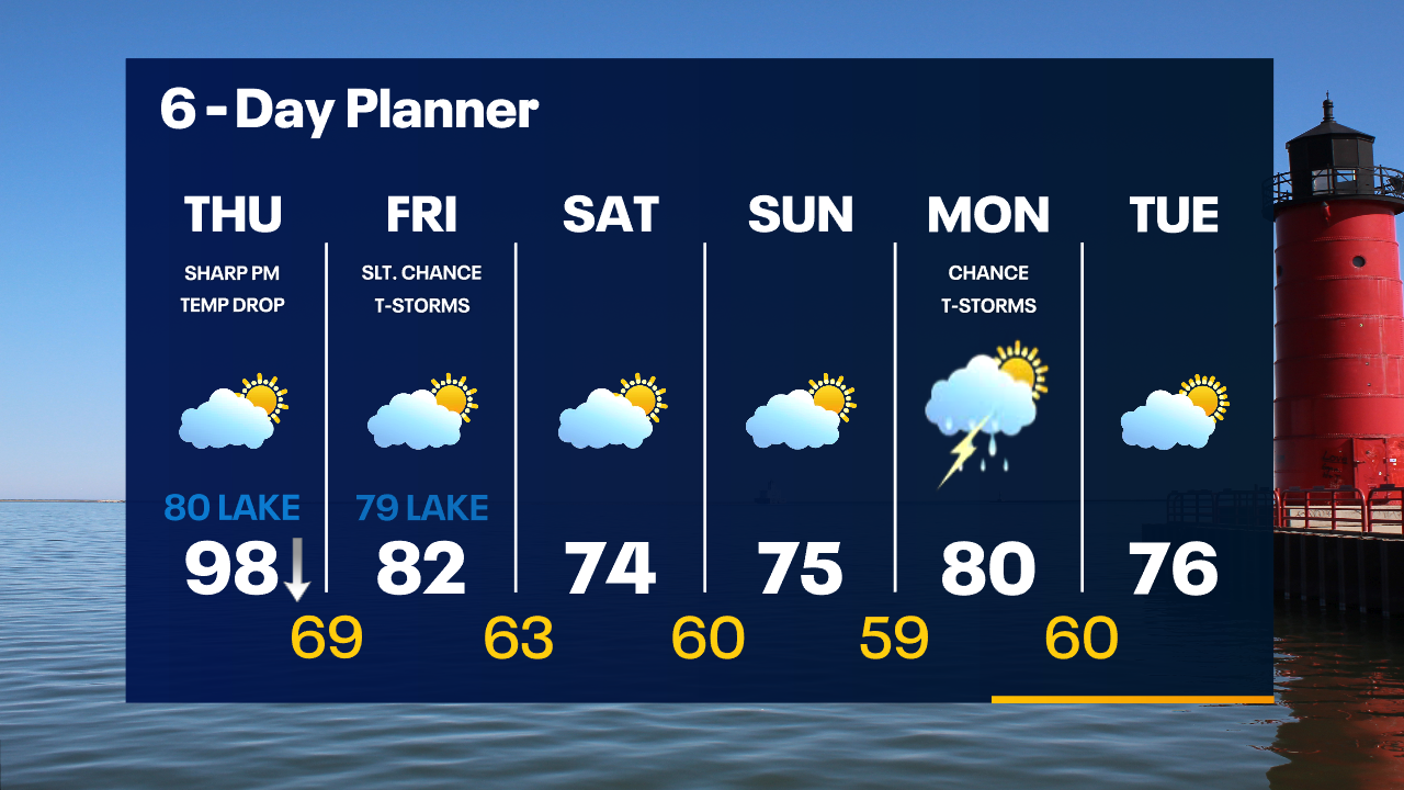
We get a break from the heat today behind yesterday's cold front. Highs will be in the low 80s inland and in the 70s lakeside with a NE-E wind all day. There is a chance for showers later today as a second cold front passes through. Highs will fall into the low 70s this weekend behind that front but with high pressure returning, we get the sun back. Our next chance of showers and thunderstorms arrives Monday and into Tuesday. Temperatures remain on the cooler side into the middle of next week.
We get a break from the heat today behind yesterday's cold front. Highs will be in the low 80s inland and in the 70s lakeside with a NE-E wind all day. There is a chance for showers later today as a second cold front passes through. Highs will fall into the low 70s this weekend behind that front but with high pressure returning, we get the sun back. Our next chance of showers and thunderstorms arrives Monday and into Tuesday. Temperatures remain on the cooler side into the middle of next week.
Weather Webcast with Tom Wachs
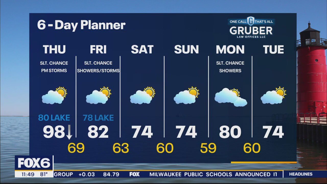
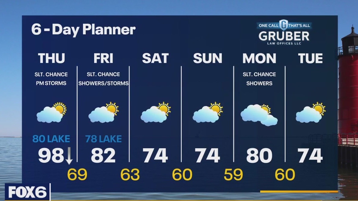
Areas of fog overnight with temperatures dropping into the 60s. Partly to mostly cloudy with a few afternoon showers possible Friday. Highs in the 70s near the lake, 80s inland.
Areas of fog overnight with temperatures dropping into the 60s. Partly to mostly cloudy with a few afternoon showers possible Friday. Highs in the 70s near the lake, 80s inland.
Weather Webcast with Meteorologist Eric Manges
Cooler temperatures return in no time with highs struggling to hit the mid 70s by Saturday
Cooler temperatures return in no time with highs struggling to hit the mid 70s by Saturday
Weather webcast with Rob Haswell
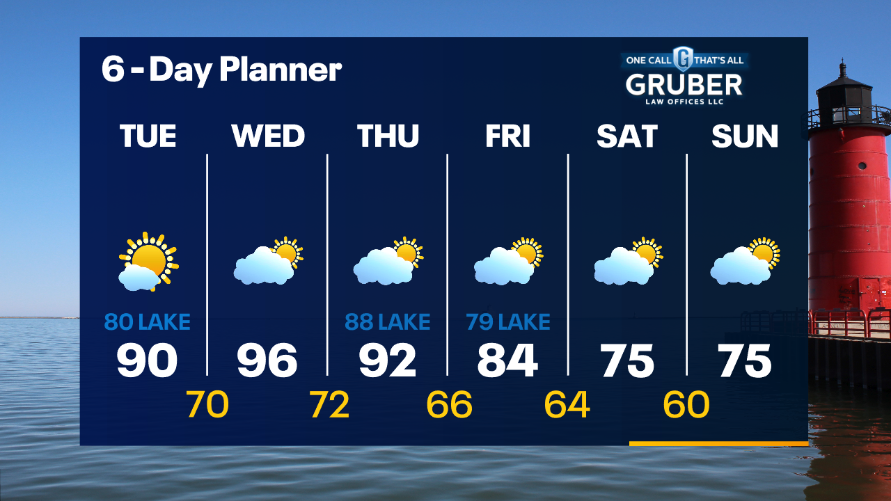
Excessive Heat Warning for Milwaukee, Waukesha, Washington, Dodge, Jefferson, Walworth, Racine & Kenosha until 7pm Today We remain on the hot side of a frontal boundary to our north today and temperatures will once again surge into the 90s. The far northeast counties of Sheboygan and Ozaukee will be slightly cooler. A low and its cold front will drop through our area later today and tonight. As that passes, the wind shifts to the NE and temperatures will fall quickly in the later afternoon and evening. There is a chance for thunderstorms to fire up along the passing cold front - particularly in the southernmost counties. We should cool into the 70s by the weekend.
Excessive Heat Warning for Milwaukee, Waukesha, Washington, Dodge, Jefferson, Walworth, Racine & Kenosha until 7pm Today We remain on the hot side of a frontal boundary to our north today and temperatures will once again surge into the 90s. The far northeast counties of Sheboygan and Ozaukee will be slightly cooler. A low and its cold front will drop through our area later today and tonight. As that passes, the wind shifts to the NE and temperatures will fall quickly in the later afternoon and evening. There is a chance for thunderstorms to fire up along the passing cold front - particularly in the southernmost counties. We should cool into the 70s by the weekend.
Weather Webcast with Tom Wachs
Excessive heat again on Thursday, especially away from the lake. Lake Michigan will provide relief by mid-afternoon in Milwaukee as temperature dip into the 70s. The cooler air will spread inland by evening.
Excessive heat again on Thursday, especially away from the lake. Lake Michigan will provide relief by mid-afternoon in Milwaukee as temperature dip into the 70s. The cooler air will spread inland by evening.
Weather Webcast with Tom Wachs
We broke a record high in Milwaukee on Wednesday with triple-digit heat and a heat index as high as 115. Another hot day Thursday, except a big drop is expected near the lake in the afternoon.
We broke a record high in Milwaukee on Wednesday with triple-digit heat and a heat index as high as 115. Another hot day Thursday, except a big drop is expected near the lake in the afternoon.

Weather Webcast with Meteorologist Eric Manges
Hottest temperatures of the year a long with the highest feel like temperatures of the year until a weekend cool down
Hottest temperatures of the year a long with the highest feel like temperatures of the year until a weekend cool down
Weather webcast with Rob Haswell
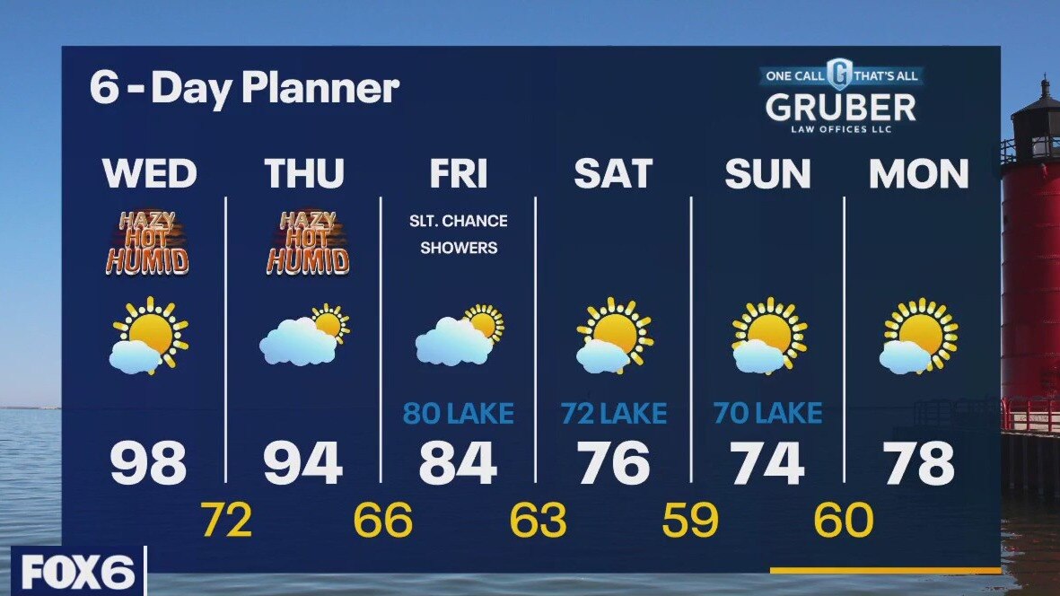
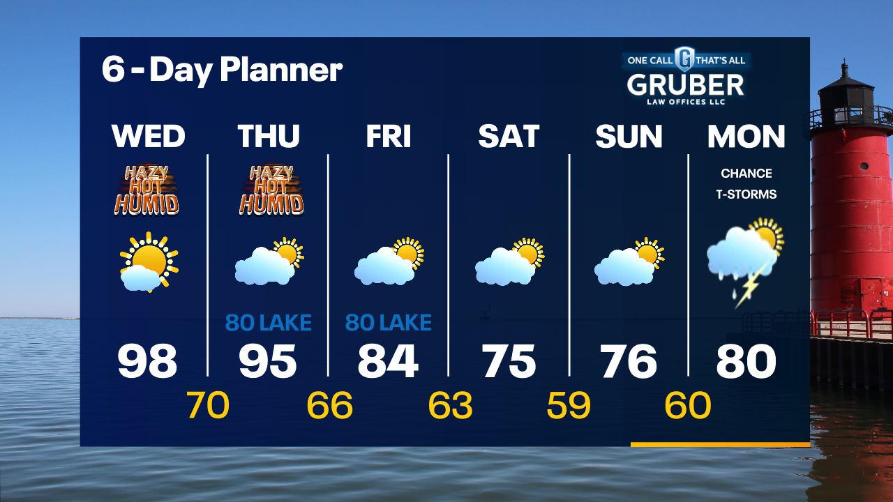
Excessive Heat Warning for all of SE WI from 10am Today until 7pm Thursday. Hot, hazy and humid today through Thursday. Temperatures will be in the upper 90s to near 100. Dewpoints will be well into the 70s meaning Heat Index values will be in the 110+ range at times. We cool down on Friday and drop into the 70s this weekend. Other than a slight chance for a few showers on Friday, we stay dry through early next week.
Excessive Heat Warning for all of SE WI from 10am Today until 7pm Thursday. Hot, hazy and humid today through Thursday. Temperatures will be in the upper 90s to near 100. Dewpoints will be well into the 70s meaning Heat Index values will be in the 110+ range at times. We cool down on Friday and drop into the 70s this weekend. Other than a slight chance for a few showers on Friday, we stay dry through early next week.
Weather Webcast with Tom Wachs
Excessive Heat Warning on Wednesday. Record highs near 100 possible with a heat index as high as 115. This is dangerous heat, please be careful.
Excessive Heat Warning on Wednesday. Record highs near 100 possible with a heat index as high as 115. This is dangerous heat, please be careful.
Weather Webcast with Tom Wachs
Mostly clear tonight with temperatures in the 70s. Excessive Heat Warning on Wednesday. Dangerous heat. Highs near 100 and a heat index as high as 110.
Mostly clear tonight with temperatures in the 70s. Excessive Heat Warning on Wednesday. Dangerous heat. Highs near 100 and a heat index as high as 110.
Weather Webcast With Lisa Michaels
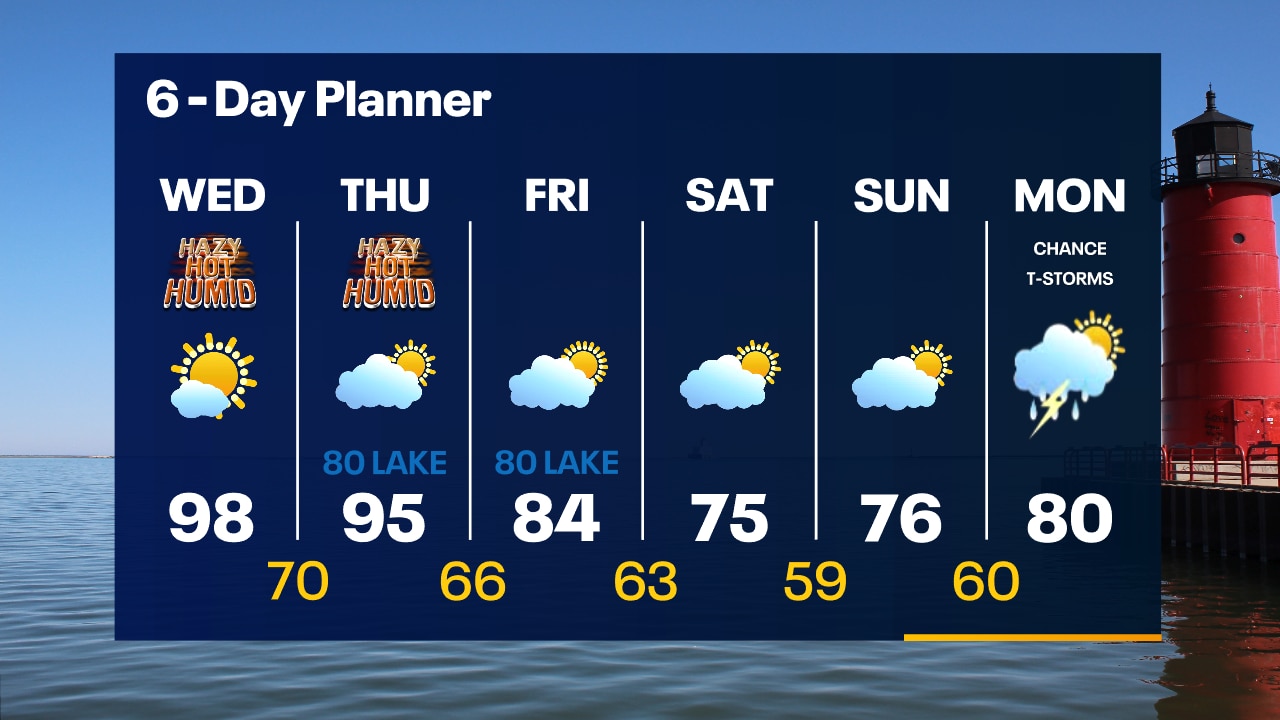
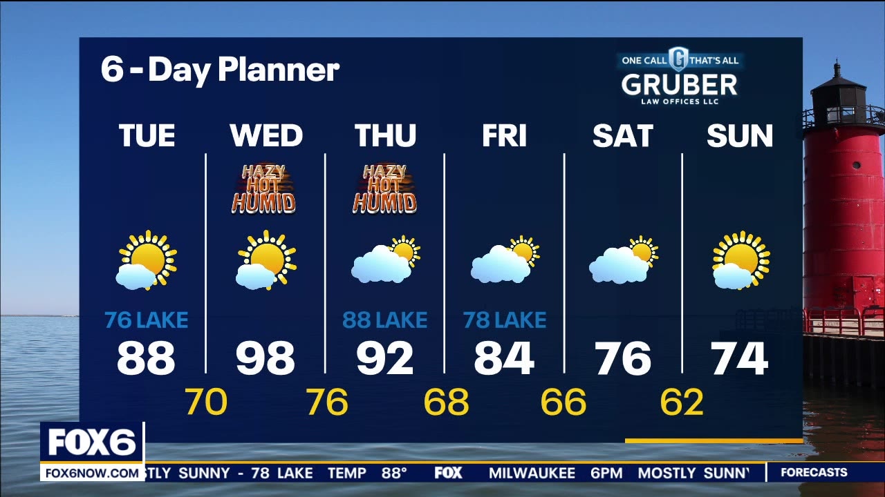
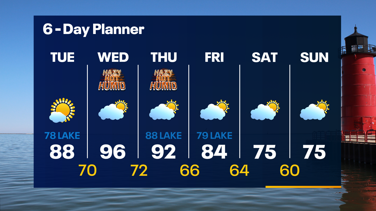
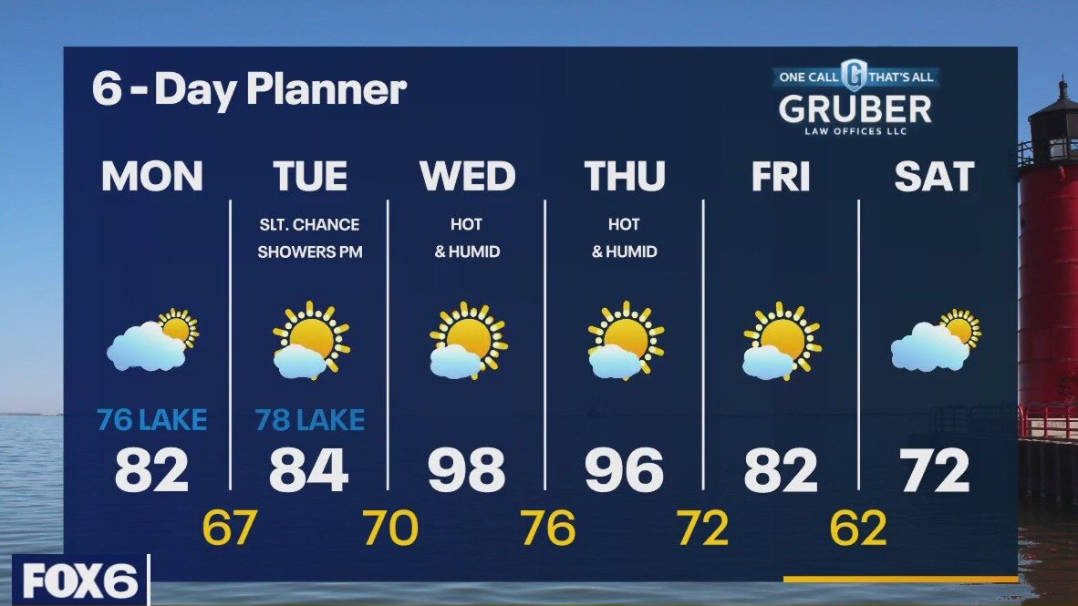
Excessive Heat Warning starts WED 10AM - Excessive Heat Watch continues through Thursday evening. Partly cloudy skies turning to mostly sunny. Today, inland areas will reach the upper 80s but a steady SE wind will keep things in the upper 70s lakeside. Warm front lifts over us tomrrow causing hot temps to arrive in the upper 90s and near 100 across SE Wisconsin. Heat index values will be in the 110+ range. We stay hot for some areas on Thursday but cool into the 70s by the weekend. No significant rain in expected for the next several days.
Excessive Heat Warning starts WED 10AM - Excessive Heat Watch continues through Thursday evening. Partly cloudy skies turning to mostly sunny. Today, inland areas will reach the upper 80s but a steady SE wind will keep things in the upper 70s lakeside. Warm front lifts over us tomrrow causing hot temps to arrive in the upper 90s and near 100 across SE Wisconsin. Heat index values will be in the 110+ range. We stay hot for some areas on Thursday but cool into the 70s by the weekend. No significant rain in expected for the next several days.
Weather webcast with Rob Haswell
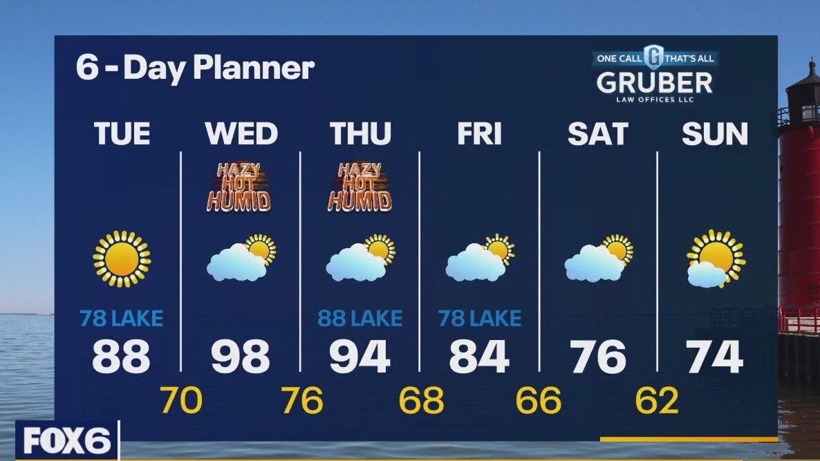
Excessive Heat Warning starts Wednesday at 10 a.m. Excessive Heat Watch continues through Thursday evening. Watching a warm front today as it moves our way, eventually bringing excessive heat. Inland areas today will reach the upper 80s but a steady SE wind will keep things in the upper 70s lakeside. Behind the warm front tomorrow, we surge to the upper 90s and near 100 across SE Wisconsin. Heat index values will be in the 110+ range. Take care. We stay hot on Thursday but cool into the 70s by the weekend. No significant rain in expected for the next several days.
Excessive Heat Warning starts Wednesday at 10 a.m. Excessive Heat Watch continues through Thursday evening. Watching a warm front today as it moves our way, eventually bringing excessive heat. Inland areas today will reach the upper 80s but a steady SE wind will keep things in the upper 70s lakeside. Behind the warm front tomorrow, we surge to the upper 90s and near 100 across SE Wisconsin. Heat index values will be in the 110+ range. Take care. We stay hot on Thursday but cool into the 70s by the weekend. No significant rain in expected for the next several days.
Weather Webcast with Tom Wachs
Mostly sunny on Tuesday with highs in the upper 80s west of Waukesha, upper 70s near the lake. Hot and humid on Wednesday with highs in the mid-90s and a heat index above 100.
Mostly sunny on Tuesday with highs in the upper 80s west of Waukesha, upper 70s near the lake. Hot and humid on Wednesday with highs in the mid-90s and a heat index above 100.
Weather Webcast with Tom Wachs
Excessive Heat Warning posted Wednesday and Thursday. Wednesday looks to be the hottest day with highs in the mid-90s and a heat index around 104.
Excessive Heat Warning posted Wednesday and Thursday. Wednesday looks to be the hottest day with highs in the mid-90s and a heat index around 104.
Weather webcast with Rob Haswell
High pressure remains the dominant feature over the area for a few days, keeping us dry and partly to mostly sunny. Today, a Northeasterly wind will help keep us a bit cooler with low 80s inland and 70s lakeside. Our far West and Southwest counties will warm further on Tuesday but 70s are likely lakeside and Northeast. The big heat arrives on Wednesday and Thursday with highs pushing into the upper 90s. Much cooler by the weekend.
High pressure remains the dominant feature over the area for a few days, keeping us dry and partly to mostly sunny. Today, a Northeasterly wind will help keep us a bit cooler with low 80s inland and 70s lakeside. Our far West and Southwest counties will warm further on Tuesday but 70s are likely lakeside and Northeast. The big heat arrives on Wednesday and Thursday with highs pushing into the upper 90s. Much cooler by the weekend.

Weather Webcast with Meteorologist Eric Manges
Some of the hottest conditions of the year are possible mid-week but still no rain in the forecast anytime soon
Some of the hottest conditions of the year are possible mid-week but still no rain in the forecast anytime soon
Weather Webcast with Meteorologist Eric Manges
Cooler start to the week but some of the warmest temperatures of the year possible Thursday
Cooler start to the week but some of the warmest temperatures of the year possible Thursday