

Weather Webcast with Tom Wachs
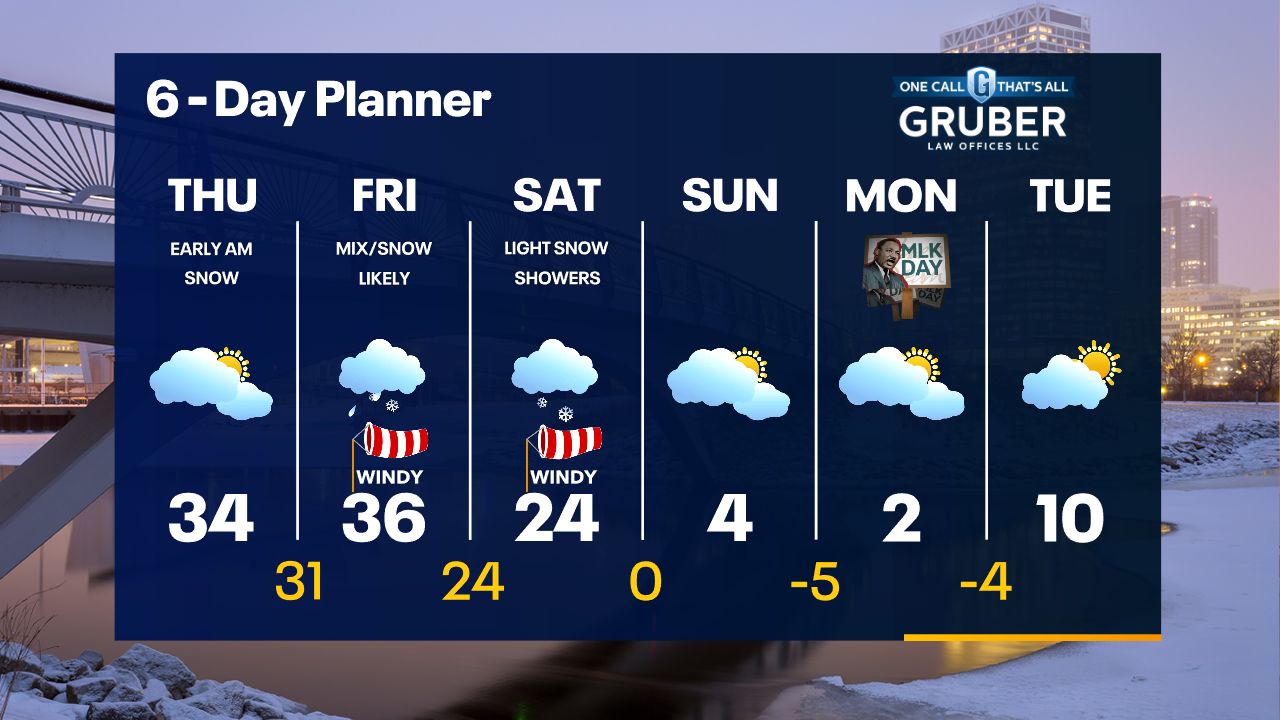
1-3" of snow overnight between 10pm-6am. Dry on Thursday. Winter Storm Watch on Friday for a mix/snow.
1-3" of snow overnight between 10pm-6am. Dry on Thursday. Winter Storm Watch on Friday for a mix/snow.

Weather Webcast with Stephanie Barichello
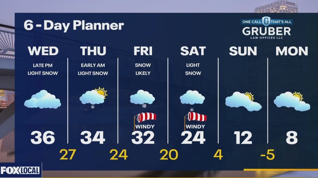
Cloudy this afternoon then light snow moves in this evening and wraps up early Thursday morning. 1-2" possible but Thursday morning's commute could be messy in spots. A bigger system is expected Friday into Saturday with heavy snow, several inches of accumulation and high wind. Then bitter cold settles in.
Cloudy this afternoon then light snow moves in this evening and wraps up early Thursday morning. 1-2" possible but Thursday morning's commute could be messy in spots. A bigger system is expected Friday into Saturday with heavy snow, several inches of accumulation and high wind. Then bitter cold settles in.
Weather webcast with Rob Haswell
A break from the snow most of the day today before a small disturbance arrives overnight. Temperatures will be steady in the low to mid 30s most of the day and cool only slightly to the mid to upper 20s tonight. A fresh round of light snow arrives overnight into early Thursday morning with around 1" possible. A more substantial snow is expected Friday into Saturday morning.
A break from the snow most of the day today before a small disturbance arrives overnight. Temperatures will be steady in the low to mid 30s most of the day and cool only slightly to the mid to upper 20s tonight. A fresh round of light snow arrives overnight into early Thursday morning with around 1" possible. A more substantial snow is expected Friday into Saturday morning.

Weather Webcast with Tom Wachs
A final band of snow will move through the area through 3am. It will stay windy with temperatures in the upper 20s overnight. Mainly cloudy and dry Wednesday. Another round of 1-1.5" of snow moves through Wednesday night.
A final band of snow will move through the area through 3am. It will stay windy with temperatures in the upper 20s overnight. Mainly cloudy and dry Wednesday. Another round of 1-1.5" of snow moves through Wednesday night.
Weather Webcast with Tom Wachs
Tuesday Mid-Afternoon snow update.
Tuesday Mid-Afternoon snow update.
Weather webcast with Rob Haswell
Winter Weather Advisory in effect until 6am Today. Winter Storm Warning from 6am Today through 3am Wednesday. Total 6-12" inland and 5-9" near the lake. A storm low moving through today and tonight will bring periods of heavy and, at times wet, snow. It will also generate a very strong wind gusting inexcess of 30mph. Snow winds down early Wednesday day but more snow is possible later this week.
Winter Weather Advisory in effect until 6am Today. Winter Storm Warning from 6am Today through 3am Wednesday. Total 6-12" inland and 5-9" near the lake. A storm low moving through today and tonight will bring periods of heavy and, at times wet, snow. It will also generate a very strong wind gusting inexcess of 30mph. Snow winds down early Wednesday day but more snow is possible later this week.
Weather Webcast with Tom Wachs
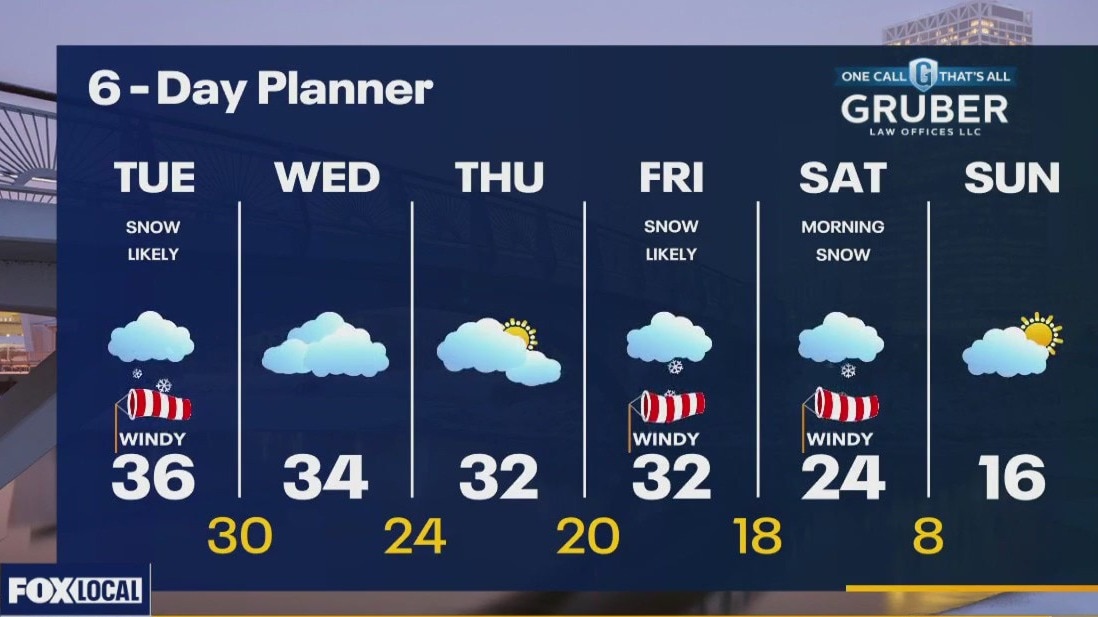
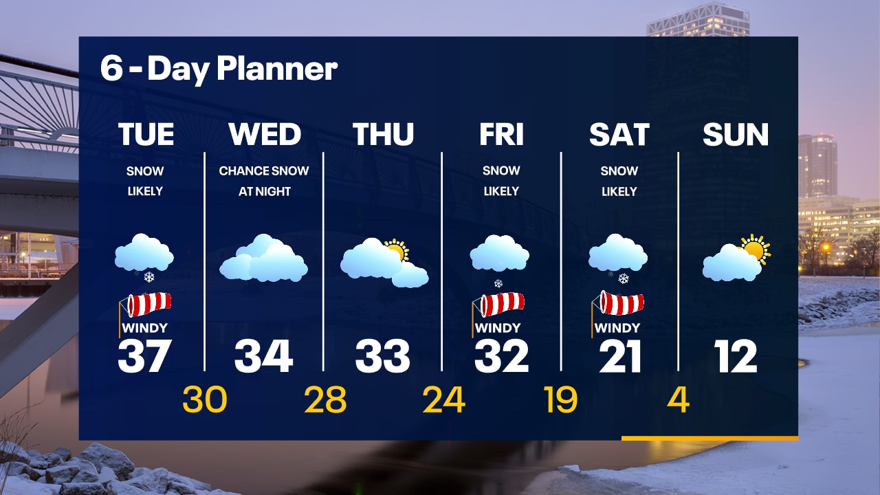
Winter Storm Warning Tuesday. Snowy and windy overnight and throughout the day Tuesday. A mix is likely at times near the lake. 6-10" inland, 4-8" near the lake. Snow ends late Tuesday night/early Wednesday morning.
Winter Storm Warning Tuesday. Snowy and windy overnight and throughout the day Tuesday. A mix is likely at times near the lake. 6-10" inland, 4-8" near the lake. Snow ends late Tuesday night/early Wednesday morning.

Weather Webcast with Tom Wachs
Winter Storm Warning on Tuesday for all of SE WI. Tuesday will be a mess with snow and wind (mix possible at times near the lake). Morning and evening commutes will be slow, with the evening commute likely the worst.
Winter Storm Warning on Tuesday for all of SE WI. Tuesday will be a mess with snow and wind (mix possible at times near the lake). Morning and evening commutes will be slow, with the evening commute likely the worst.

Weather Webcast with Stephanie Barichello
Light snow begins tonight, then picks up in intensity by late Tuesday morning. It'll be a very messy day with tricky travel and several inches of snowfall accumulation. There are a few more snow chances, too, the rest of the week.
Light snow begins tonight, then picks up in intensity by late Tuesday morning. It'll be a very messy day with tricky travel and several inches of snowfall accumulation. There are a few more snow chances, too, the rest of the week.

Weather webcast with Lisa Michales
Winter Weather Advisory for 9 p.m. tonight through 6 a.m. Tuesday. 1-3" of snow possible. Winter Storm Watch and Warning from 6 a.m. Tuesday through 3 a.m. Wednesday. Total 5-9" inland and 3-7" near the lake. Another small chance of snowfall late Wednesday night. Watching a third system that could bring snow over the weekend with a very cold air mass following it.
Winter Weather Advisory for 9 p.m. tonight through 6 a.m. Tuesday. 1-3" of snow possible. Winter Storm Watch and Warning from 6 a.m. Tuesday through 3 a.m. Wednesday. Total 5-9" inland and 3-7" near the lake. Another small chance of snowfall late Wednesday night. Watching a third system that could bring snow over the weekend with a very cold air mass following it.
Weather Webcast with Tom Wachs
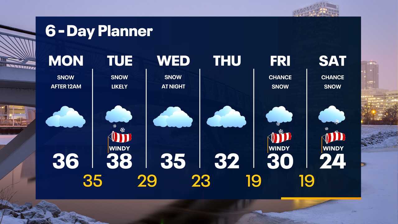
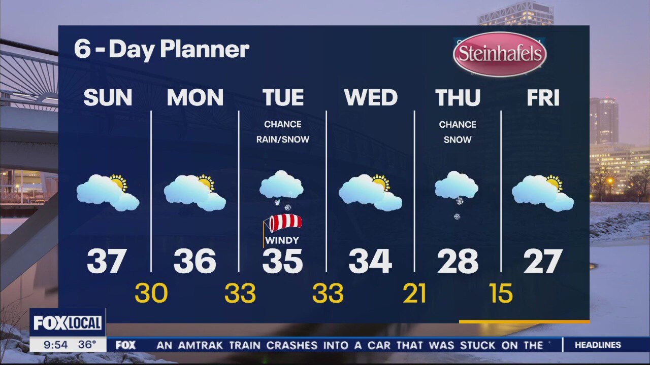
Cloudy on Monday with highs in the 30s. Snow moves in after 11pm Monday. Snowy and windy ALL DAY Tuesday with snow ending around 3am Wednesday. 5-9" inland, a little lower near the lake with a mix possible.
Cloudy on Monday with highs in the 30s. Snow moves in after 11pm Monday. Snowy and windy ALL DAY Tuesday with snow ending around 3am Wednesday. 5-9" inland, a little lower near the lake with a mix possible.

Weather Webcast with Tom Wachs
Winter Storm Watch Tuesday. Dry tonight and Monday. Snow starts after 12am Tuesday with the heaviest snow throughout the day. 5-9" inland, 3-6" near the lake.
Winter Storm Watch Tuesday. Dry tonight and Monday. Snow starts after 12am Tuesday with the heaviest snow throughout the day. 5-9" inland, 3-6" near the lake.
Weather webcast with Lisa Michaels
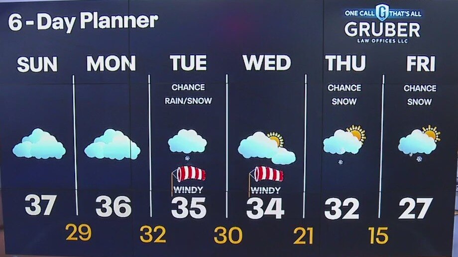
Cloudy and dry Sunday. A few flurries possible. Watching a larger storm system that will bring rain/snow on Monday night through Wednesday morning. Another few systems could bring some snow Thursday into next weekend. A surge of cold air moves in by the middle of the month.
Cloudy and dry Sunday. A few flurries possible. Watching a larger storm system that will bring rain/snow on Monday night through Wednesday morning. Another few systems could bring some snow Thursday into next weekend. A surge of cold air moves in by the middle of the month.
Weather Webcast with Meteorologist Eric Manges
Multiple snow chances moving forward as an active winter weather pattern shifts in
Multiple snow chances moving forward as an active winter weather pattern shifts in

Weather Webcast with Meteorologist Eric Manges
Nice little snow to start the weekend with more potential next week
Nice little snow to start the weekend with more potential next week
Weather webcast with Lisa Michaels
Snow showers Saturday especially in the morning. Most areas will remain under 1" but inland locations could see isolated spots up to 2". Another winter system could bring a mixture of rain/snow Monday night through Wednesday morning. Colder air sets up for the middle and end of next week.
Snow showers Saturday especially in the morning. Most areas will remain under 1" but inland locations could see isolated spots up to 2". Another winter system could bring a mixture of rain/snow Monday night through Wednesday morning. Colder air sets up for the middle and end of next week.

Weather Webcast with Meteorologist Eric Manges
Multiple snow chances heading into next week
Multiple snow chances heading into next week
Weather Webcast with Stephanie Barichello
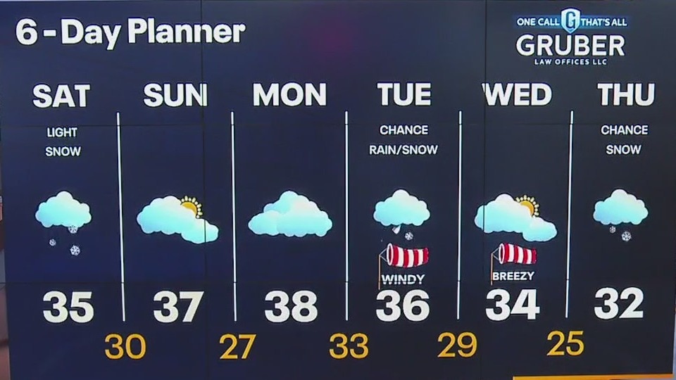
Cloudy today then light snow on Saturday with up to 1" of accumulation. Flurries Sunday and still mild in the upper 30s. More of a rain/snow mix is looking possible Tuesday, so plan on sloppy day.
Cloudy today then light snow on Saturday with up to 1" of accumulation. Flurries Sunday and still mild in the upper 30s. More of a rain/snow mix is looking possible Tuesday, so plan on sloppy day.
Weather webcast with Rob Haswell
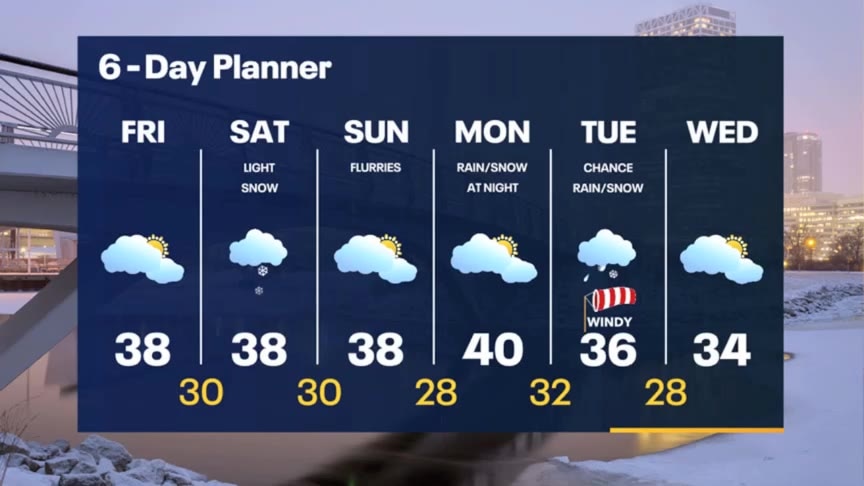
A southwest wind today will bring warmer and slightly more moist air to our region. Highs will warm a bit to the upper 30s and dewpoints will climb. We should stay dry today but a disturbance arrives Saturday with a chance for light snow. A few tenths of an inch are likely. Temperatures remain above average this weekend with highs in the upper 30s to near 40 but cooler air arrives by the mid to late part of next week.
A southwest wind today will bring warmer and slightly more moist air to our region. Highs will warm a bit to the upper 30s and dewpoints will climb. We should stay dry today but a disturbance arrives Saturday with a chance for light snow. A few tenths of an inch are likely. Temperatures remain above average this weekend with highs in the upper 30s to near 40 but cooler air arrives by the mid to late part of next week.
Weather Webcast with Tom Wachs
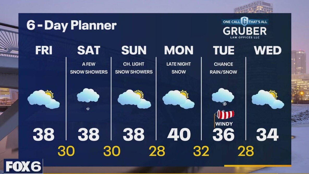
Mostly cloudy overnight with temperatures in the 20s. Mostly cloudy and mild on Friday with highs in the 30s. Snow showers are possible on Saturday with highs in the mid-to-upper 30s.
Mostly cloudy overnight with temperatures in the 20s. Mostly cloudy and mild on Friday with highs in the 30s. Snow showers are possible on Saturday with highs in the mid-to-upper 30s.