

Weather Webcast with Tom Wachs
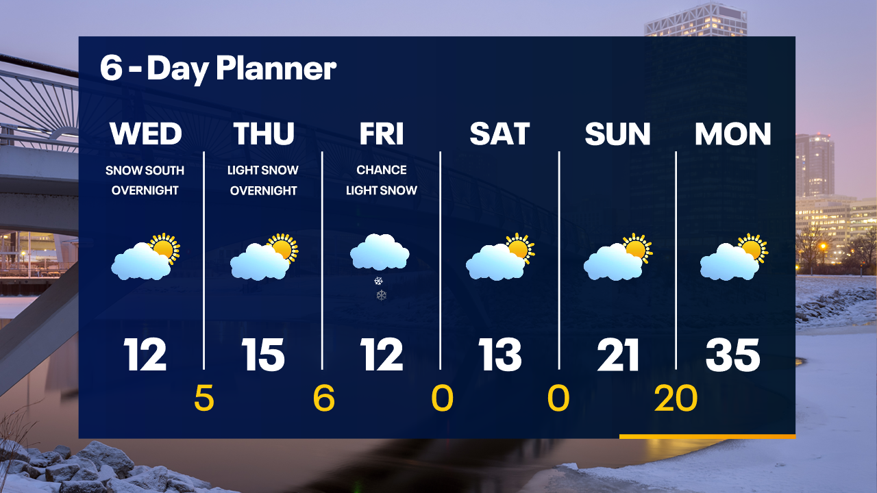
Wind Chill Advisory until 9am Wednesday. Bitter cold air continues. It will stay cold into the weekend. Light snow is possible south of Milwaukee late Wednesday night.
Wind Chill Advisory until 9am Wednesday. Bitter cold air continues. It will stay cold into the weekend. Light snow is possible south of Milwaukee late Wednesday night.
Weather Webcast with Tom Wachs
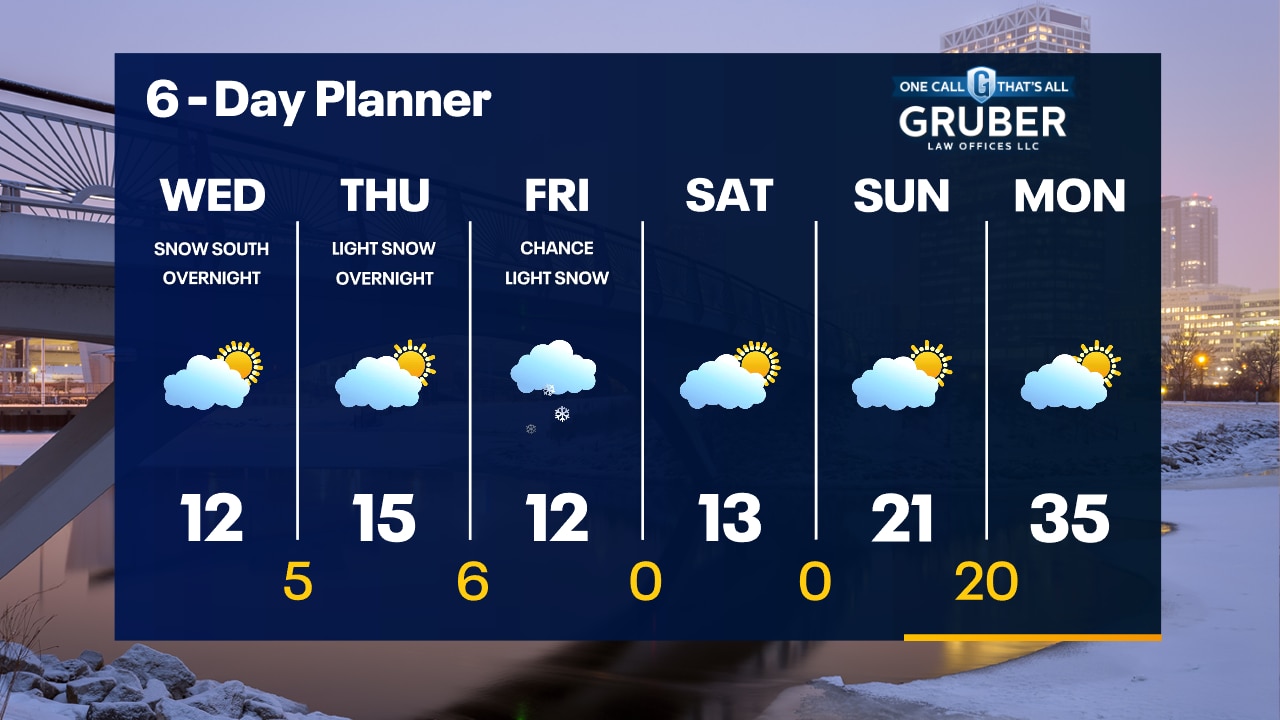
Wind Chill Advisory until 9am Wednesday. The cold continues. Light snow is possible south of Milwaukee late Wednesday night with a greater chance on Friday.
Wind Chill Advisory until 9am Wednesday. The cold continues. Light snow is possible south of Milwaukee late Wednesday night with a greater chance on Friday.

Weather webcast with Lisa Michaels
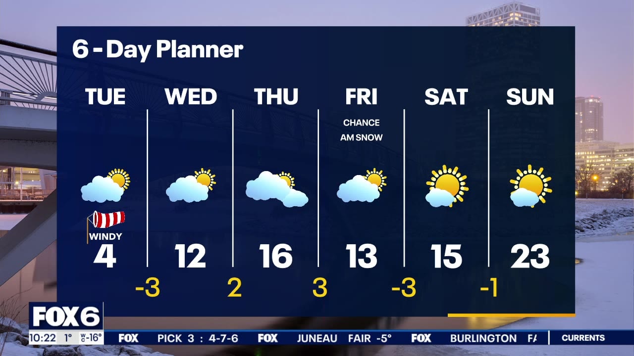
Wind Chill Advisory through 9am on Wednesday! Another very cold morning with a strong wind from the west, turning southwest. Morning wind chills will range from -20 to -35 at times. With some sun we will warm slightly to a few degrees above zero by this afternoon. Wind chills will be in the -15 to -25 range this afternoon. We slowly warm late week and get back to the low 20s by Sunday. There is a chance for a few snow showers late Thursday and through the day on Friday but otherwise dry.
Wind Chill Advisory through 9am on Wednesday! Another very cold morning with a strong wind from the west, turning southwest. Morning wind chills will range from -20 to -35 at times. With some sun we will warm slightly to a few degrees above zero by this afternoon. Wind chills will be in the -15 to -25 range this afternoon. We slowly warm late week and get back to the low 20s by Sunday. There is a chance for a few snow showers late Thursday and through the day on Friday but otherwise dry.

Weather webcast with Rob Haswell
Wind Chill Advisory through 9am on Wednesday! Another very cold morning with a strong wind from the west, turning southwest. Morning wind chills will range from -20 to -35 at times. With some sun we will warm slightly to a few degrees above zero by this afternoon. Wind chills will be in the -15 to -25 range this afternoon. We slowly warm late week and get back to the low 20s by Sunday. There is a chance for a few snow showers late Thursday and through the day on Friday but otherwise dry.
Wind Chill Advisory through 9am on Wednesday! Another very cold morning with a strong wind from the west, turning southwest. Morning wind chills will range from -20 to -35 at times. With some sun we will warm slightly to a few degrees above zero by this afternoon. Wind chills will be in the -15 to -25 range this afternoon. We slowly warm late week and get back to the low 20s by Sunday. There is a chance for a few snow showers late Thursday and through the day on Friday but otherwise dry.
Weather webcast with Lisa Michaels
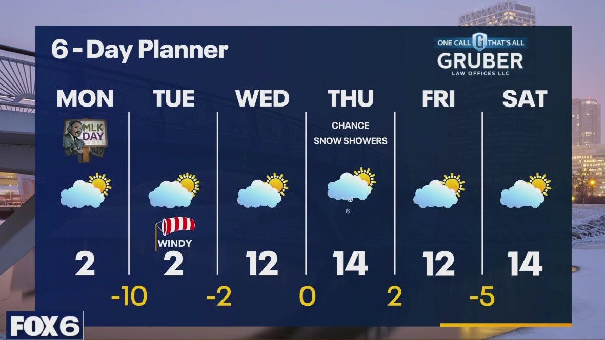
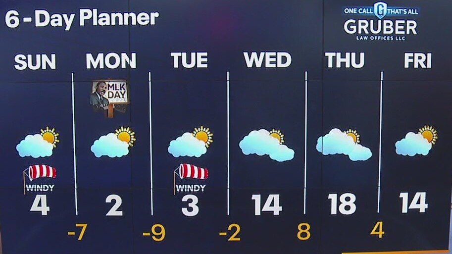
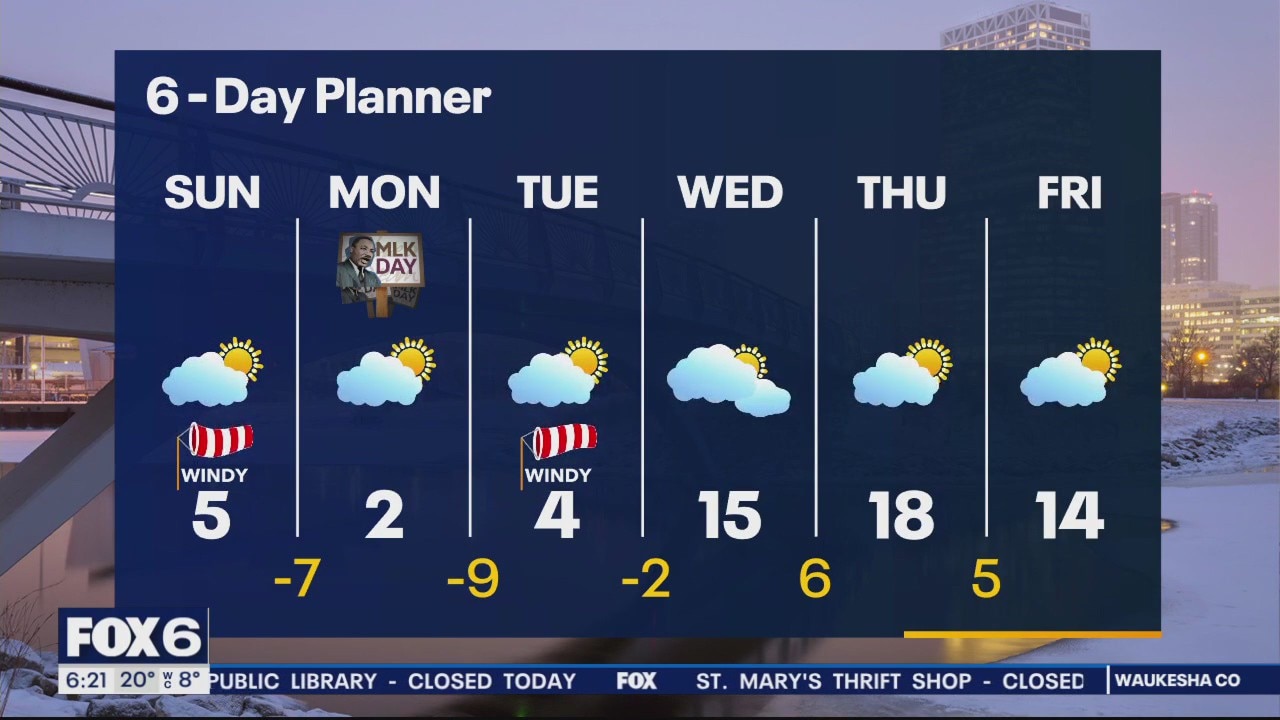
Wind Chill Advisory through 9am on Wednesday Low temperature tonight have a shot at getting to -10 especially for areas inland. Slight chance of some light snow Thursday night into Friday morning. No impacts expected. Slowly warming back into the 20s by the end of the weekend and into next week.
Wind Chill Advisory through 9am on Wednesday Low temperature tonight have a shot at getting to -10 especially for areas inland. Slight chance of some light snow Thursday night into Friday morning. No impacts expected. Slowly warming back into the 20s by the end of the weekend and into next week.

Weather Webcast with Meteorologist Eric Manges
Dangerous cold through Wednesday morning but we do see some improvements to end the month
Dangerous cold through Wednesday morning but we do see some improvements to end the month
Weather webcast with Rob Haswell
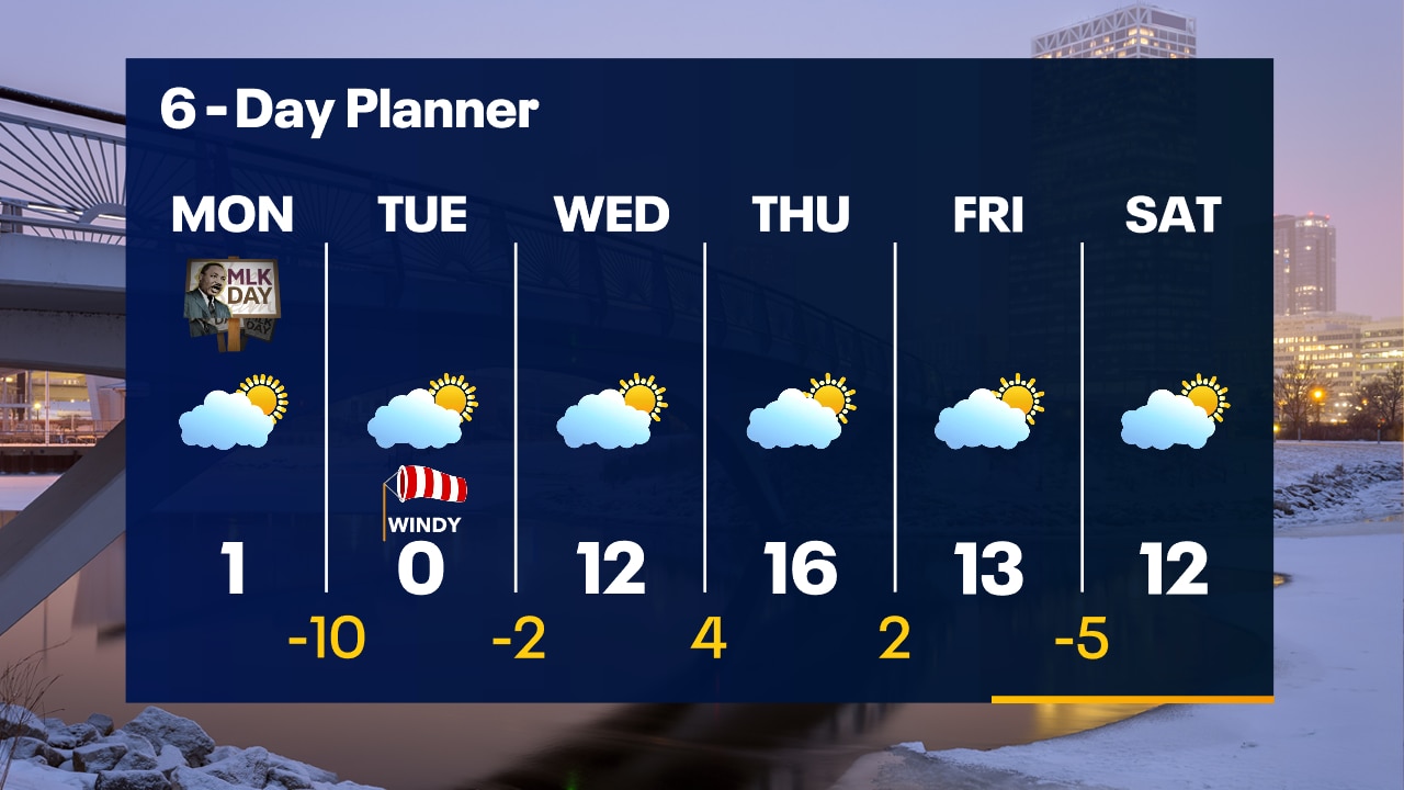
Wind Chill Advisory through 9am on Wednesday! A very cold Arctic air mass is in place. Daytime highs will struggle to get just above zero for the next couple of days. A strong West, turning Northwest, wind will make things feel more like 15 to 30 below zero at times. Even as we warm slightly later this week, highs will barely reach the teens above. There is a chance for a few snow showers on Thursday but we are mostly dry this week.
Wind Chill Advisory through 9am on Wednesday! A very cold Arctic air mass is in place. Daytime highs will struggle to get just above zero for the next couple of days. A strong West, turning Northwest, wind will make things feel more like 15 to 30 below zero at times. Even as we warm slightly later this week, highs will barely reach the teens above. There is a chance for a few snow showers on Thursday but we are mostly dry this week.
Weather Webcast with Tom Wachs
Wind Chill Advisory through Noon Monday. AM Wind Chill: -20 to -34. Afternoon Wind Chill: -15 to -25. No major storm systems in sight, but the cold will last all week.
Wind Chill Advisory through Noon Monday. AM Wind Chill: -20 to -34. Afternoon Wind Chill: -15 to -25. No major storm systems in sight, but the cold will last all week.

Weather Webcast with Tom Wachs
Wind Chill Advisory for all of SE WI through Noon Monday. Wind chills -15 to -25 this evening, -20 to -34 by morning, -15 to -25 Monday afternoon.
Wind Chill Advisory for all of SE WI through Noon Monday. Wind chills -15 to -25 this evening, -20 to -34 by morning, -15 to -25 Monday afternoon.
Weather webcast with Lisa Michaels
Wind chill advisory today through noon on Monday. Wind chills -20 to -34 in the evenings. Daytime wind chills -15 to -25. Single-digit high temperatures Sunday, Monday, and Tuesday. Slight warm-up back into the teens on Wednesday.
Wind chill advisory today through noon on Monday. Wind chills -20 to -34 in the evenings. Daytime wind chills -15 to -25. Single-digit high temperatures Sunday, Monday, and Tuesday. Slight warm-up back into the teens on Wednesday.
Weather Webcast with Meteorologist Eric Manges
Dangerous cold moves in to end the weekend and lasts into next week
Dangerous cold moves in to end the weekend and lasts into next week
Weather webcast with Lisa Michaels
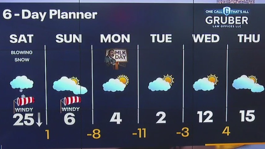
Winter Weather Advisory through noon Saturday for light snow accumulation and blowing snow with low visibility. Falling temperatures Saturday in the 20s. Wind chills in the single digits. Bitterly cold temps move in starting Saturday night through next week. Wind chills tonight -5 to -15F.
Winter Weather Advisory through noon Saturday for light snow accumulation and blowing snow with low visibility. Falling temperatures Saturday in the 20s. Wind chills in the single digits. Bitterly cold temps move in starting Saturday night through next week. Wind chills tonight -5 to -15F.
Weather Webcast with Tom Wachs
Snow becomes lighter overnight but it will stay windy. Roads will remain slick. Temperatures will drop into the 20s overnight. Around 1" of fluffier snow on Saturday with strong winds and temperatures in the 20s.
Snow becomes lighter overnight but it will stay windy. Roads will remain slick. Temperatures will drop into the 20s overnight. Around 1" of fluffier snow on Saturday with strong winds and temperatures in the 20s.

Weather webcast with Stephanie Barichello
Moderate snow and strong winds continue throughout the night. Snow will get a little lighter overnight.
Moderate snow and strong winds continue throughout the night. Snow will get a little lighter overnight.

Weather webcast with Rob Haswell
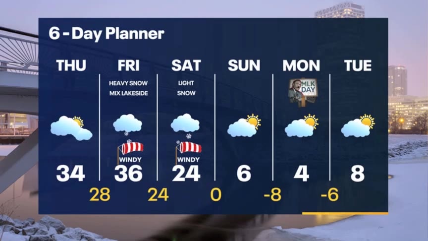
Winter Storm Warning for All of SE WI from 6 a.m. today (Friday) to Noon Saturday Snow moving across our area this morning. Periods of heavy snow at times. Some lakeside areas may see brief periods of wintry mix or rain causing lower snowfall totals. Snowfall will range from 3-6" in the far SE lakeside areas to as high as 8-12" farther inland. Much colder air arrives this weekend.
Winter Storm Warning for All of SE WI from 6 a.m. today (Friday) to Noon Saturday Snow moving across our area this morning. Periods of heavy snow at times. Some lakeside areas may see brief periods of wintry mix or rain causing lower snowfall totals. Snowfall will range from 3-6" in the far SE lakeside areas to as high as 8-12" farther inland. Much colder air arrives this weekend.
Weather Webcast with Tom Wachs
Winter Storm remains on track. Winter Storm Warning 6am Fri - 12pm Sat. Moderate snow, strong winds and low visibility throughout the day. Slow travel expected.
Winter Storm remains on track. Winter Storm Warning 6am Fri - 12pm Sat. Moderate snow, strong winds and low visibility throughout the day. Slow travel expected.
Weather Webcast with Tom Wachs
Winter Storm Warning Friday. Snow moves in from the south after 4am. The morning commute is expected to be rough with snow and strong winds. A mix is possible near the lake.
Winter Storm Warning Friday. Snow moves in from the south after 4am. The morning commute is expected to be rough with snow and strong winds. A mix is possible near the lake.
Weather Webcast with Stephanie Barichello
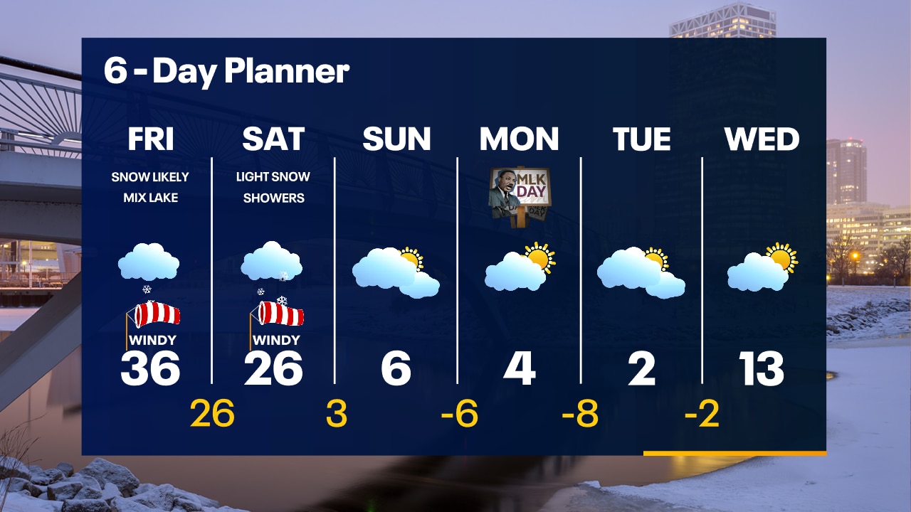
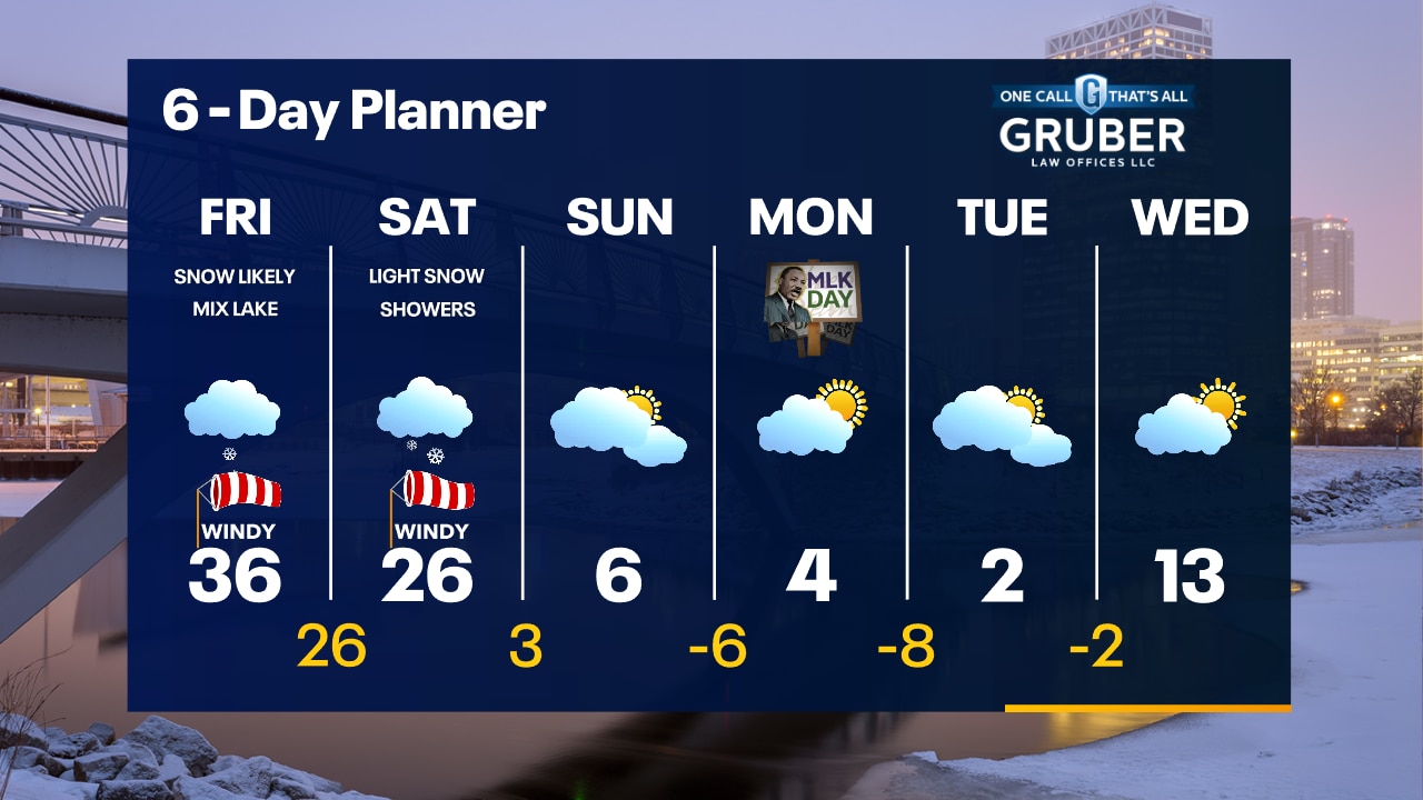
Drying out today after 2-4" of snow last night, but snow returns early Friday morning. There will likely be periods of rain and snow mix lakeside through Friday afternoon then all snow is expected Friday night and colder air filters in. Lake enhancement will also be possible in the evening, thanks to the difference in temperatures. Several inches of snow likely with this system, along with blowing snow.
Drying out today after 2-4" of snow last night, but snow returns early Friday morning. There will likely be periods of rain and snow mix lakeside through Friday afternoon then all snow is expected Friday night and colder air filters in. Lake enhancement will also be possible in the evening, thanks to the difference in temperatures. Several inches of snow likely with this system, along with blowing snow.

Weather webcast with Rob Haswell
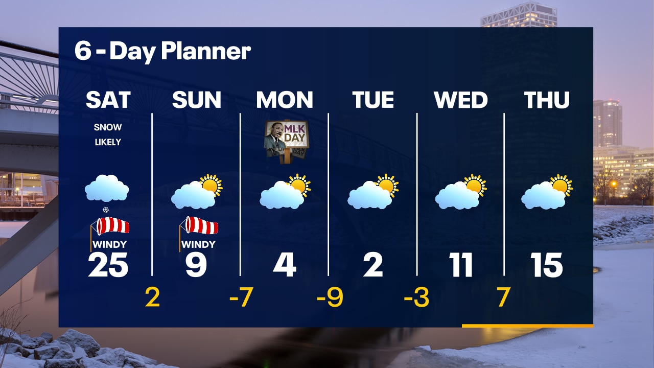
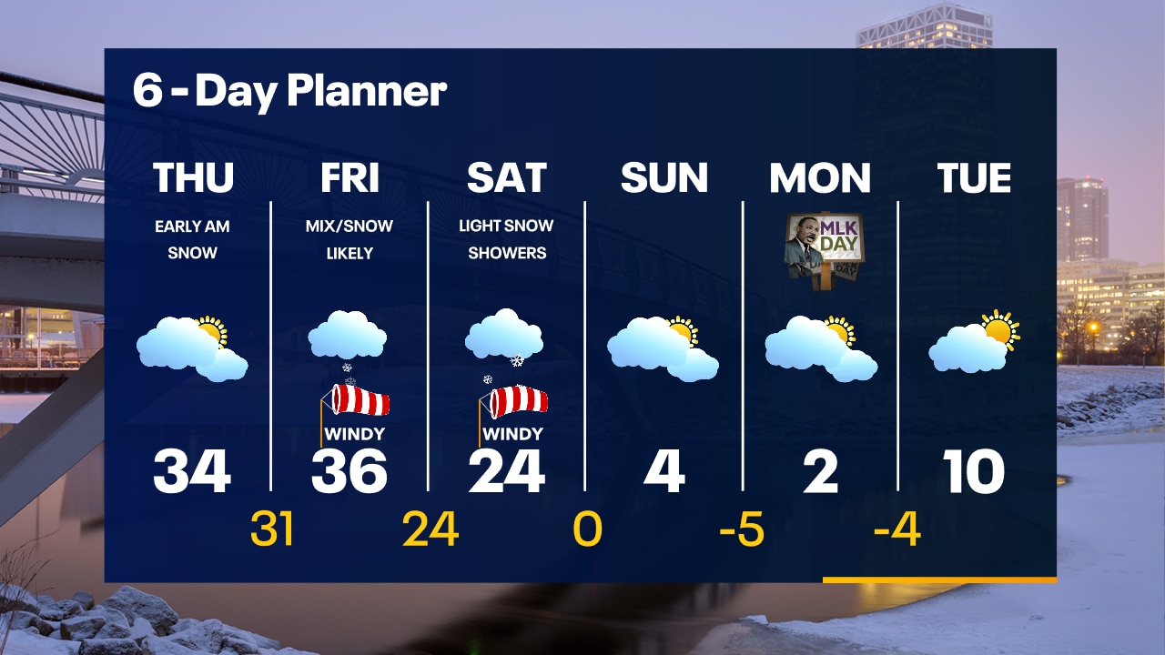
A small disturbance moves out this morning with light snow tapering off. Temperatures remain in the low to mid 30s most of the day. A much stronger system arrives Friday and lasts into Saturday. A Winter Storm Watch begins at 6am Friday and runs through Noon on Saturday. This system will bring several inches of snow, very strong wind gusts and very poor travel conditions. There is a chance for a wintry mix near Lake Michigan. After the snow winds down, much colder air arrives. Highs will fall from 20s and 30s to the single digits for several days.
A small disturbance moves out this morning with light snow tapering off. Temperatures remain in the low to mid 30s most of the day. A much stronger system arrives Friday and lasts into Saturday. A Winter Storm Watch begins at 6am Friday and runs through Noon on Saturday. This system will bring several inches of snow, very strong wind gusts and very poor travel conditions. There is a chance for a wintry mix near Lake Michigan. After the snow winds down, much colder air arrives. Highs will fall from 20s and 30s to the single digits for several days.
Weather Webcast with Tom Wachs
1-3" of slushy snow overnight. Snow ends by 6am but the AM commute could be slushy in spots. Dry on Thursday. A wintry mix and snow move in Friday morning. Winter Storm Watch Friday.
1-3" of slushy snow overnight. Snow ends by 6am but the AM commute could be slushy in spots. Dry on Thursday. A wintry mix and snow move in Friday morning. Winter Storm Watch Friday.