

Weather webcast with Lisa Michaels
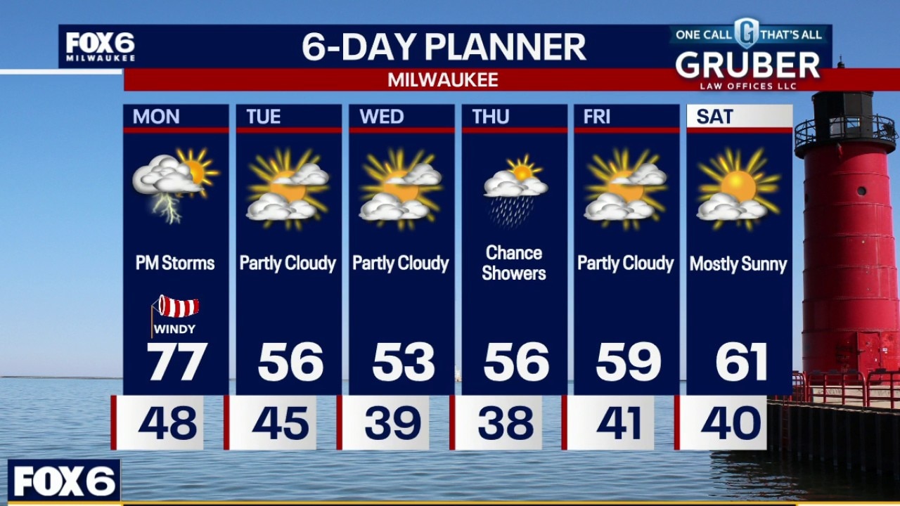
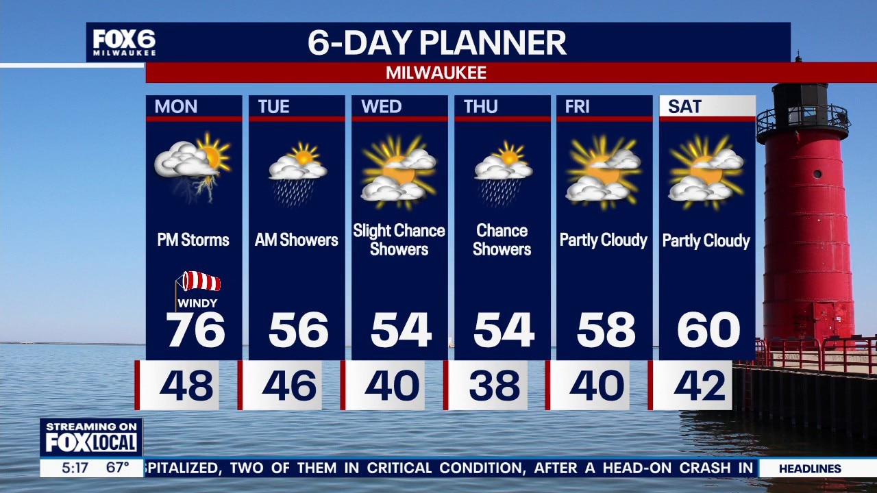
Mostly sunny morning with temps in the 40s. Windy again Monday and even warmer with temperatures in the mid 70s. Ahead of a cold front late Monday afternoon and evening, a few thunderstorms are possible.
Mostly sunny morning with temps in the 40s. Windy again Monday and even warmer with temperatures in the mid 70s. Ahead of a cold front late Monday afternoon and evening, a few thunderstorms are possible.
Weather Webcast with Stephanie Barichello
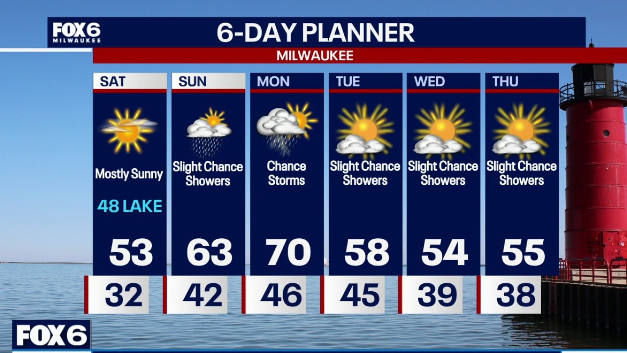
A warm and windy way to start the work week with temperatures well into the 70s. A passing cold front will bring evening thunderstorms then slightly cooler temperatures the rest of the week. Slight rain chances linger Tuesday through Thursday.
A warm and windy way to start the work week with temperatures well into the 70s. A passing cold front will bring evening thunderstorms then slightly cooler temperatures the rest of the week. Slight rain chances linger Tuesday through Thursday.
Weather webcast with meteorologist Lisa Michaels
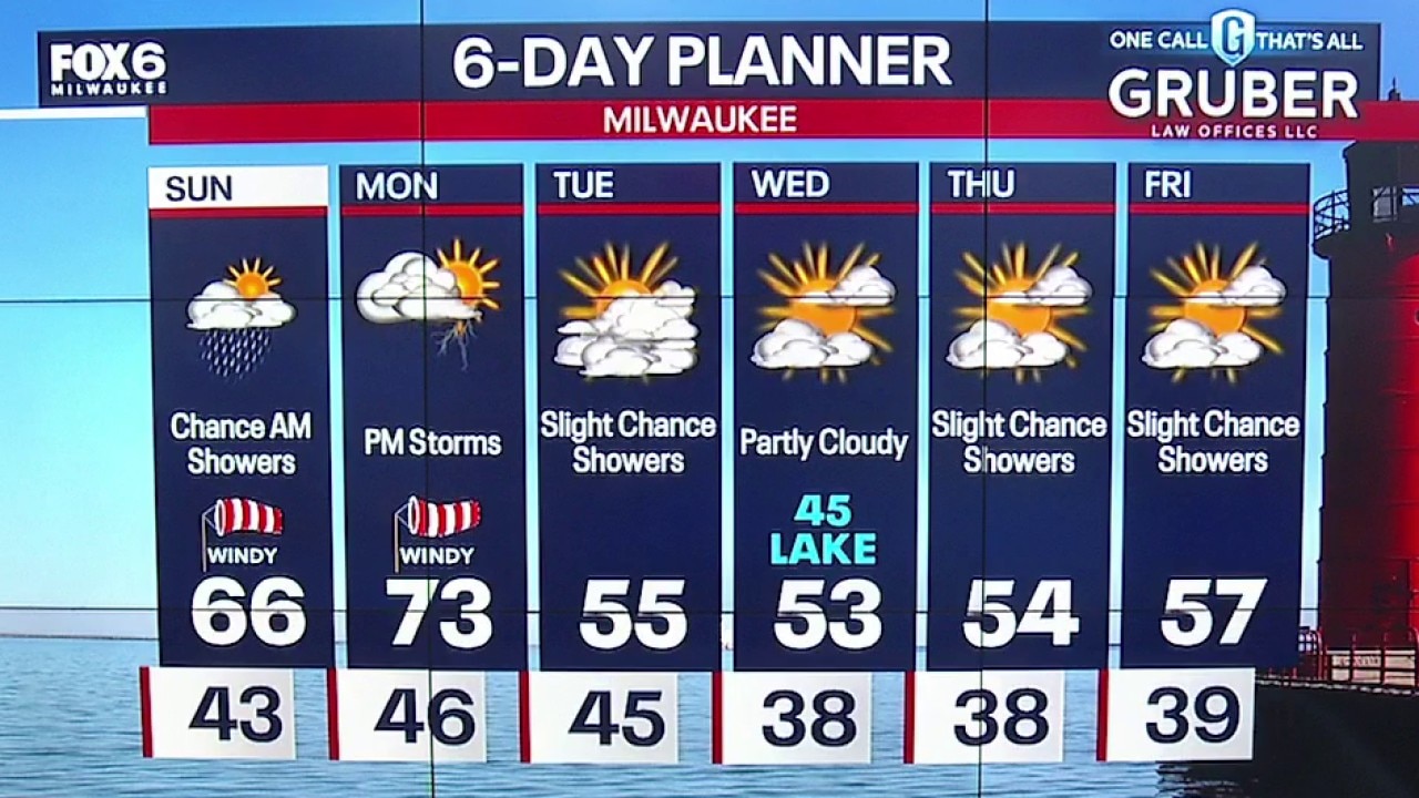
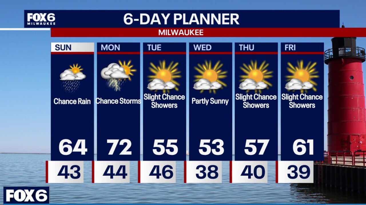
Slight chance for a few Sunday morning showers. Decreasing clouds by the afternoon with highs in the middle 60s and breezy. Warmest day of the week will be on Monday with highs in the low 70s.
Slight chance for a few Sunday morning showers. Decreasing clouds by the afternoon with highs in the middle 60s and breezy. Warmest day of the week will be on Monday with highs in the low 70s.
Webcast Weather with Holly Baker
A chance for showers is likely for Sunday into the upcoming week.
A chance for showers is likely for Sunday into the upcoming week.
Weather webcast with Meteorologist Lisa Michaels
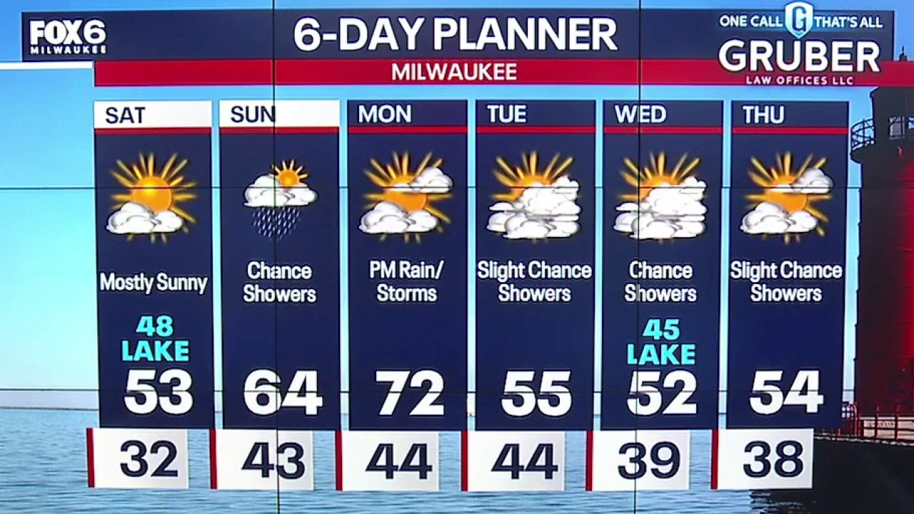
Mostly sunny Saturday with increasing clouds by the afternoon. Highs in the upper 40s near the lake to low 50s inland. More mild Saturday night with mostly cloudy skies. Temps falling into the lower 40s.
Mostly sunny Saturday with increasing clouds by the afternoon. Highs in the upper 40s near the lake to low 50s inland. More mild Saturday night with mostly cloudy skies. Temps falling into the lower 40s.
Webcast Weather with Holly Baker
A nice start to the weekend with cool temperatures. Then rain chances return by Sunday.
A nice start to the weekend with cool temperatures. Then rain chances return by Sunday.
Weather Webcast with Stephanie Barichello
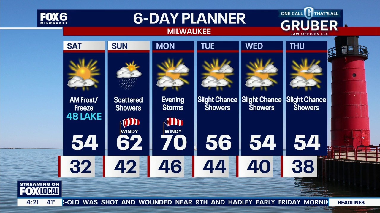
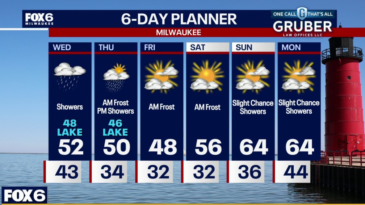
A cold and frosty night ahead with temperatures dropping into the low 30s. Sunny on Saturday with temperatures ranging from upper 40s lakeside to mid 50s inland. Scattered showers return on Sunday, then more storms Monday evening. It'll at least be warmer!
A cold and frosty night ahead with temperatures dropping into the low 30s. Sunny on Saturday with temperatures ranging from upper 40s lakeside to mid 50s inland. Scattered showers return on Sunday, then more storms Monday evening. It'll at least be warmer!
Weather webcast with Stephanie Barichello
A chilly end to the week is setting the tone, with widespread frost and even freezing temperatures expected inland both Friday morning and again early Saturday.
A chilly end to the week is setting the tone, with widespread frost and even freezing temperatures expected inland both Friday morning and again early Saturday.
Weather webcast with Rob Haswell
A chilly end to the week is setting the tone, with widespread frost and even freezing temperatures expected inland both Friday morning and again early Saturday.
A chilly end to the week is setting the tone, with widespread frost and even freezing temperatures expected inland both Friday morning and again early Saturday.
Weather Webcast with Holly Baker
A slight chance for rain is expected for Friday then dry Saturday.
A slight chance for rain is expected for Friday then dry Saturday.
Weather Webcast with Stephanie Barichello
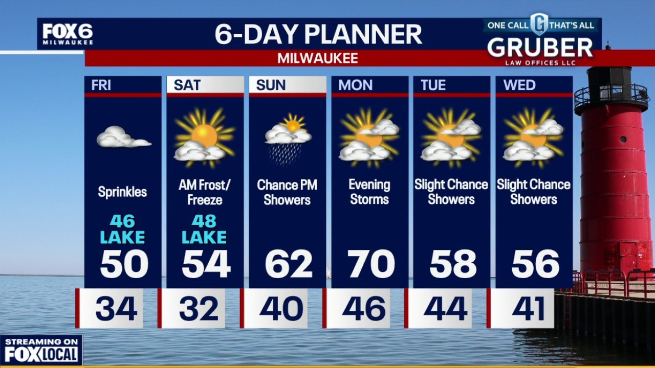
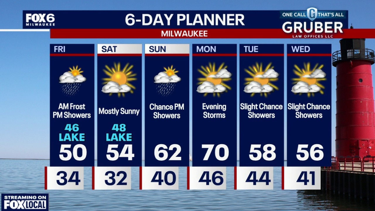
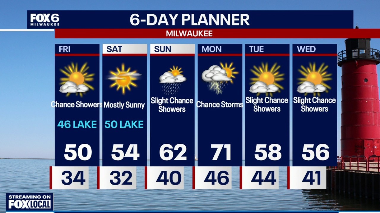
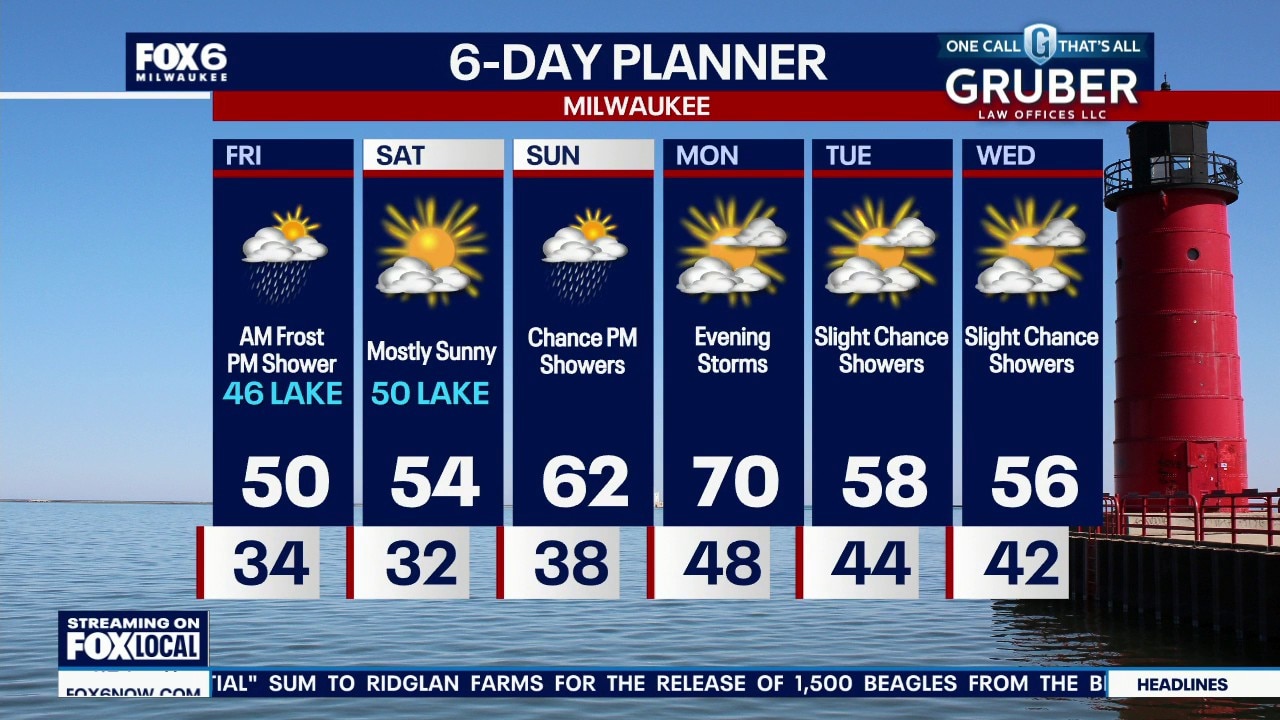
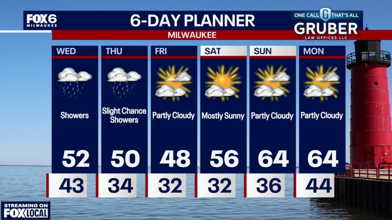
A Frost Advisory is in effect for parts of SE WI until 8am Friday, so be sure to bring in sensitive plants or cover them before bed. Some sunshine to start Friday then more clouds and a few sprinkles during the afternoon. Another frosty and cold start to Saturday, then a nicer afternoon. Showers return Sunday and late Monday but temperatures will be a bit warmer.
A Frost Advisory is in effect for parts of SE WI until 8am Friday, so be sure to bring in sensitive plants or cover them before bed. Some sunshine to start Friday then more clouds and a few sprinkles during the afternoon. Another frosty and cold start to Saturday, then a nicer afternoon. Showers return Sunday and late Monday but temperatures will be a bit warmer.
Weather webcast with Stephanie Barichello
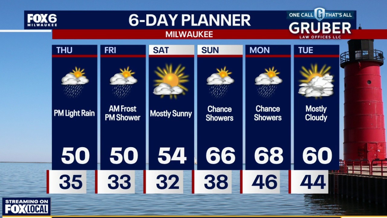
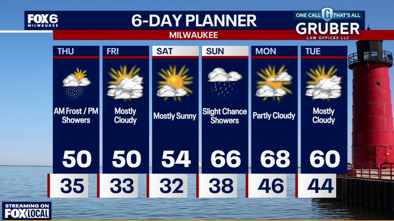
We’re stuck in a cooler, unsettled pattern to close out the workweek, with temperatures running below normal and a chilly feel sticking around. Expect scattered, hit-or-miss showers each afternoon Thursday and Friday.
We’re stuck in a cooler, unsettled pattern to close out the workweek, with temperatures running below normal and a chilly feel sticking around. Expect scattered, hit-or-miss showers each afternoon Thursday and Friday.
Weather webcast with Rob Haswell
We’re stuck in a cooler, unsettled pattern to close out the workweek, with temperatures running below normal and a chilly feel sticking around. Expect scattered, hit-or-miss showers each afternoon Thursday and Friday.
We’re stuck in a cooler, unsettled pattern to close out the workweek, with temperatures running below normal and a chilly feel sticking around. Expect scattered, hit-or-miss showers each afternoon Thursday and Friday.
Weather Webcast with Holly Baker
We are tracking cooler temperatures overnight with more rain likely Thursday.
We are tracking cooler temperatures overnight with more rain likely Thursday.
Weather webcast with Stephanie Barichello
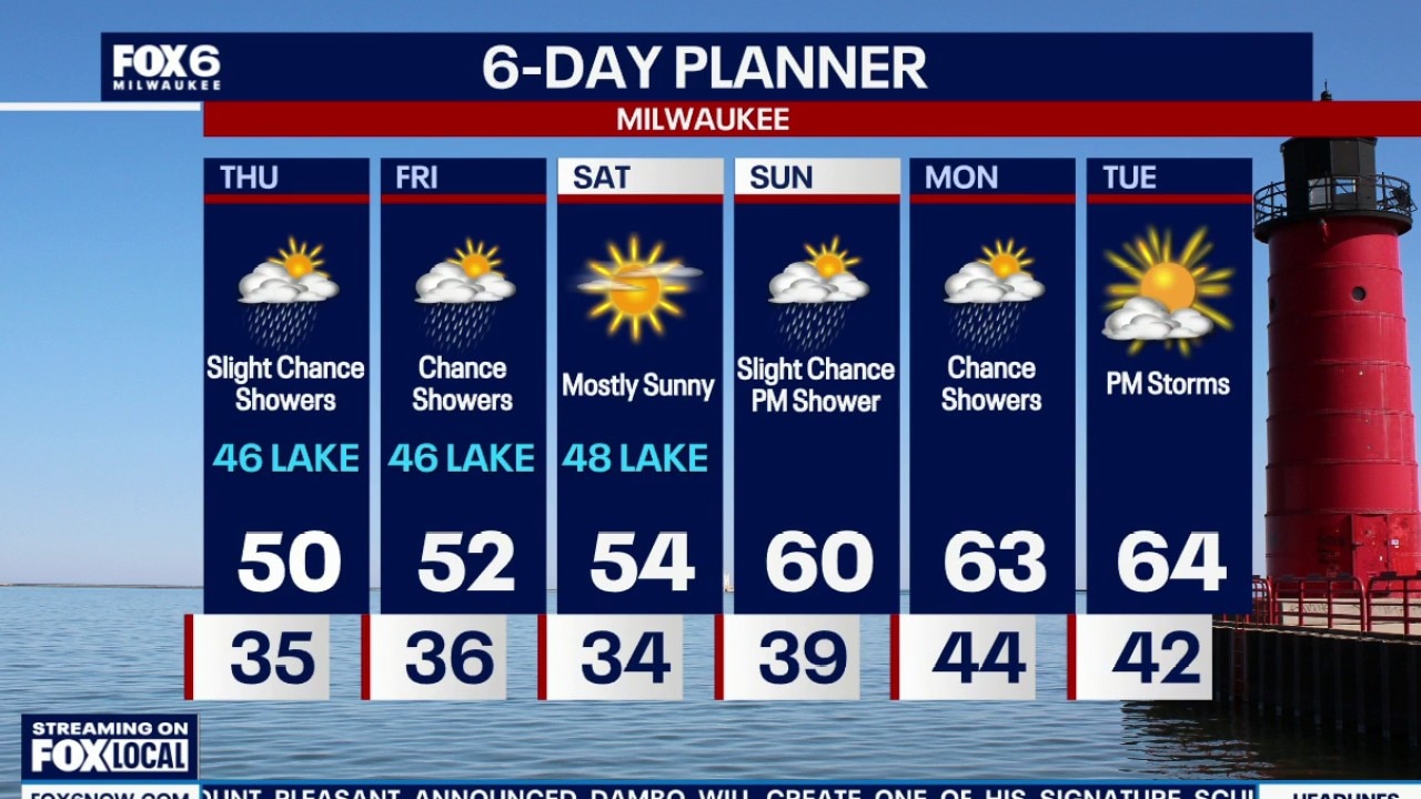
A cooler, somewhat unsettled pattern settles into southern Wisconsin through the end of the week, with off-and-on chances for light showers and even a few rumbles of thunder during the afternoons.
A cooler, somewhat unsettled pattern settles into southern Wisconsin through the end of the week, with off-and-on chances for light showers and even a few rumbles of thunder during the afternoons.
Weather webcast with Rob Haswell
A cooler, somewhat unsettled pattern settles into southern Wisconsin through the end of the week, with off-and-on chances for light showers and even a few rumbles of thunder during the afternoons.
A cooler, somewhat unsettled pattern settles into southern Wisconsin through the end of the week, with off-and-on chances for light showers and even a few rumbles of thunder during the afternoons.
Weather Webcast with Holly Baker
We are watching for a chance of showers through Thursday.
We are watching for a chance of showers through Thursday.
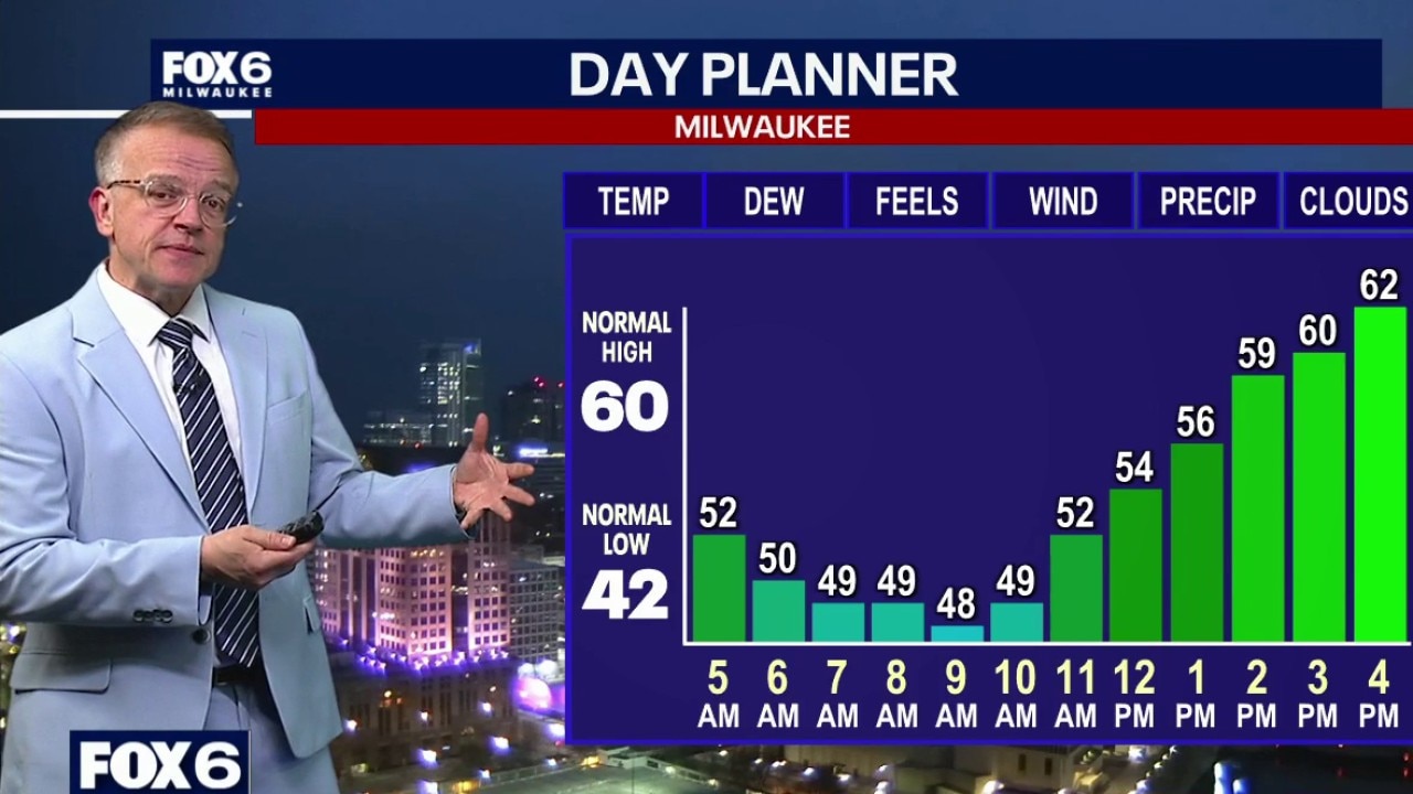
Weather Webcast with Chief Meteorologist Tom Wachs
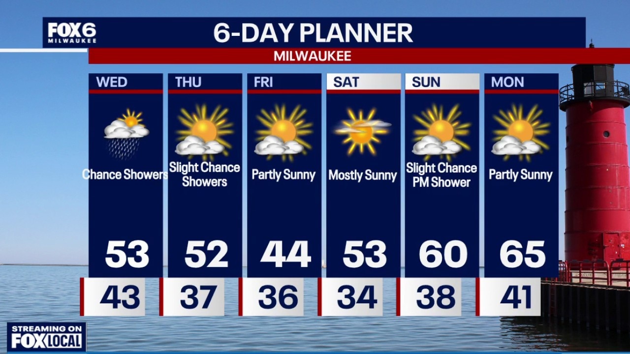
A 77mph wind gust was reported at MKE airport at 1:32pm Monday on the back side of rain showers. This caused power outages and tree damage around the city. The severe risk is LOW tonight, but not zero. Isolated t-storms ending overnight. Temperatures dropping into the 40s. Mostly cloudy and breezy on Tuesday with a high around 60. Rain showers Tuesday night into Wednesday and a slight chance on Thursday. Highs in the 50s mid-to-late week.
A 77mph wind gust was reported at MKE airport at 1:32pm Monday on the back side of rain showers. This caused power outages and tree damage around the city. The severe risk is LOW tonight, but not zero. Isolated t-storms ending overnight. Temperatures dropping into the 40s. Mostly cloudy and breezy on Tuesday with a high around 60. Rain showers Tuesday night into Wednesday and a slight chance on Thursday. Highs in the 50s mid-to-late week.
Weather webcast with Chief Meteorologist Rob Haswell
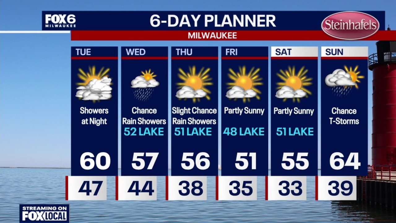
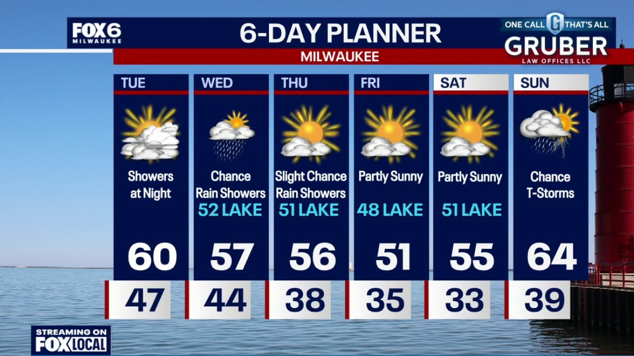
The cold front that brought Monday's storms has pushed out, and anything leftover is fading quickly as the atmosphere stabilizes. In its wake, a cooler pattern takes over with temperatures running below average through much of the week.
The cold front that brought Monday's storms has pushed out, and anything leftover is fading quickly as the atmosphere stabilizes. In its wake, a cooler pattern takes over with temperatures running below average through much of the week.
Weather Webcast with Chief Meteorologist Tom Wachs
A 77mph wind gust was reported at MKE airport at 1:32pm Monday on the back side of rain showers. This caused power outages and tree damage around the city. The severe risk is LOW tonight, but not zero. Isolated t-storms are possible until around midnight. This threat has really dropped from earlier forecasts. Widespread heavy rain is also no longer expected. The greatest threat shifted south. Temperatures will drop from the 50s into the 40s overnight.
A 77mph wind gust was reported at MKE airport at 1:32pm Monday on the back side of rain showers. This caused power outages and tree damage around the city. The severe risk is LOW tonight, but not zero. Isolated t-storms are possible until around midnight. This threat has really dropped from earlier forecasts. Widespread heavy rain is also no longer expected. The greatest threat shifted south. Temperatures will drop from the 50s into the 40s overnight.