

Weather Webcast with Chief Meteorologist Tom Wachs
Partly cloudy and warm tonight. Temperatures dropping through the 70s this evening. An isolated t-storm is possible Thursday afternoon with a few scattered storms possible Thursday evening. Pay close attention to the forecast on the 4th!
Partly cloudy and warm tonight. Temperatures dropping through the 70s this evening. An isolated t-storm is possible Thursday afternoon with a few scattered storms possible Thursday evening. Pay close attention to the forecast on the 4th!

Weather Webcast with Stephanie Barichello
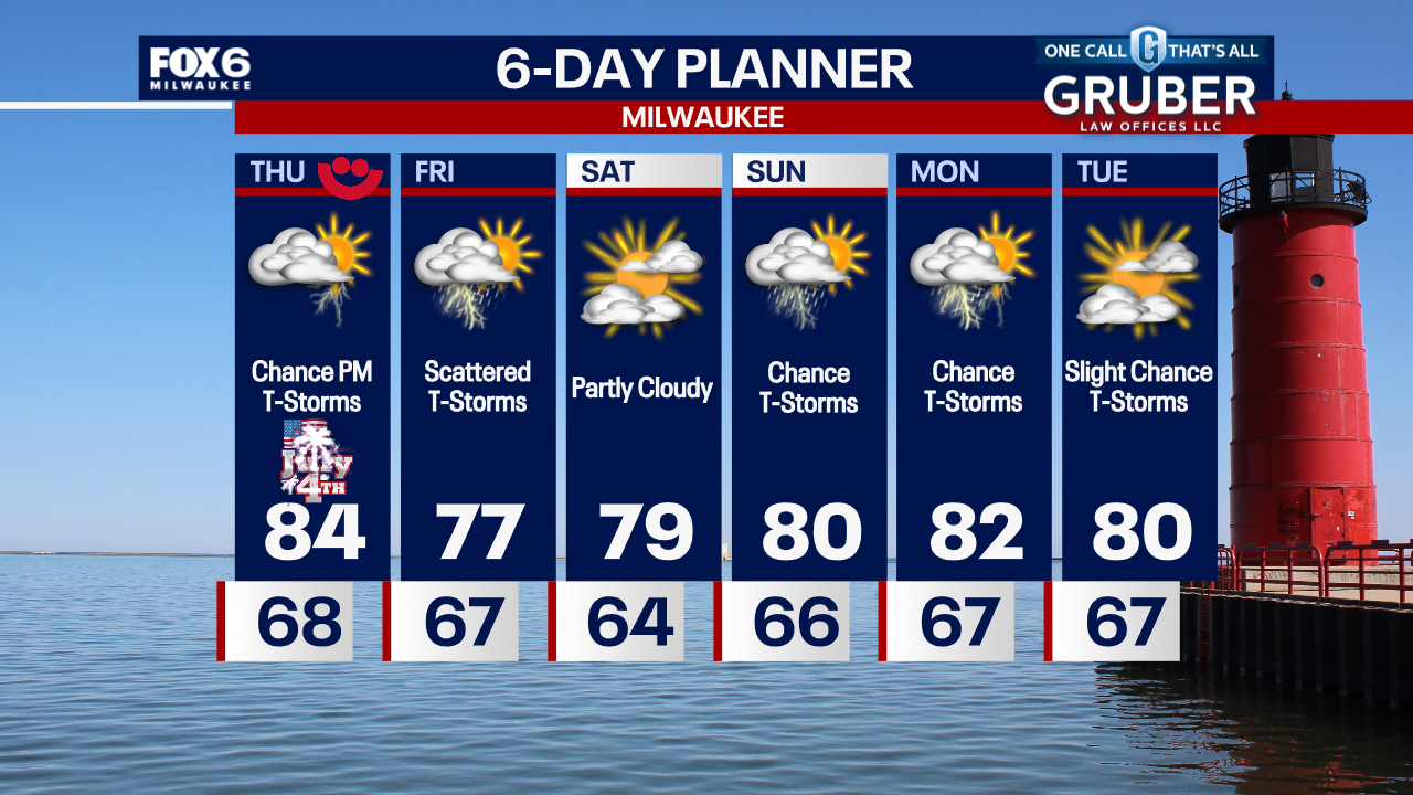
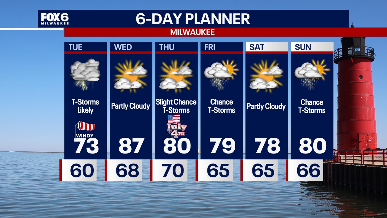
Warm and a bit humid today, but quiet tonight for any firework displays! Partly sunny for 4th of July parades Thursday morning, then there is a chance for a few pop-up t-storms in the afternoon. Most will be dry for fireworks, but another round of storms could move in as they end. Still a few more storms chances through Sunday.
Warm and a bit humid today, but quiet tonight for any firework displays! Partly sunny for 4th of July parades Thursday morning, then there is a chance for a few pop-up t-storms in the afternoon. Most will be dry for fireworks, but another round of storms could move in as they end. Still a few more storms chances through Sunday.

Weather webcast with Rob Haswell
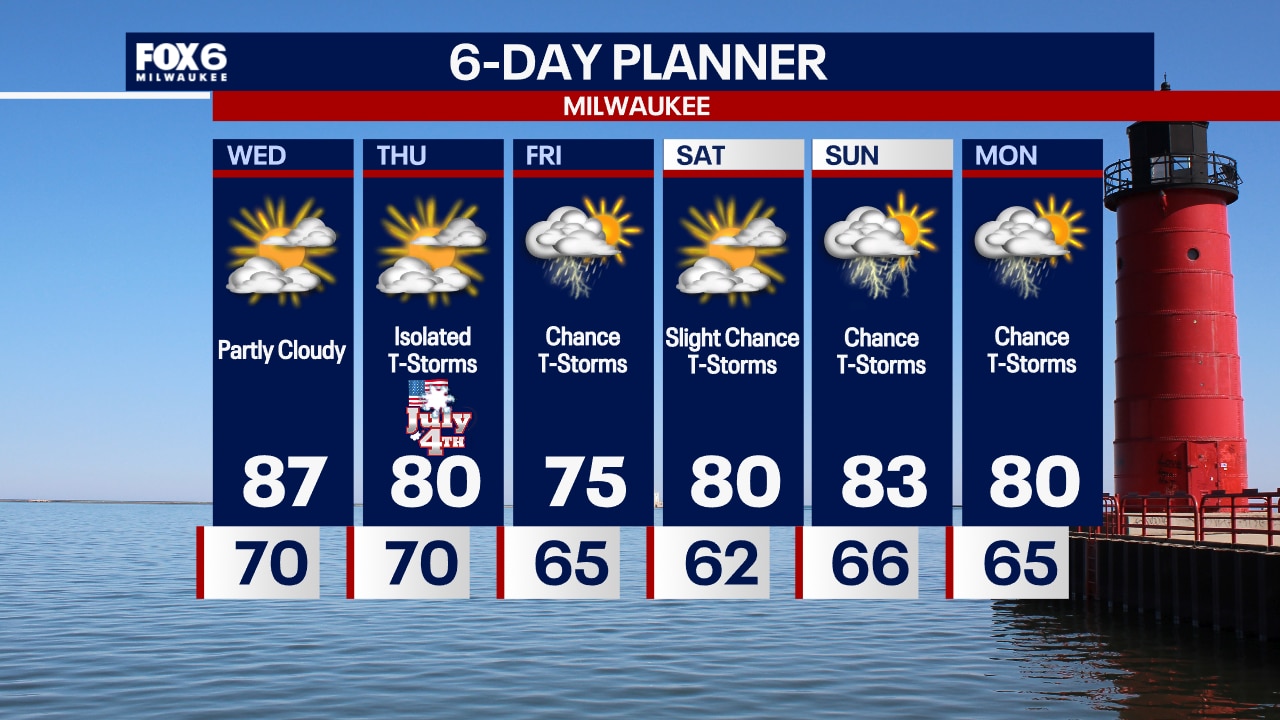
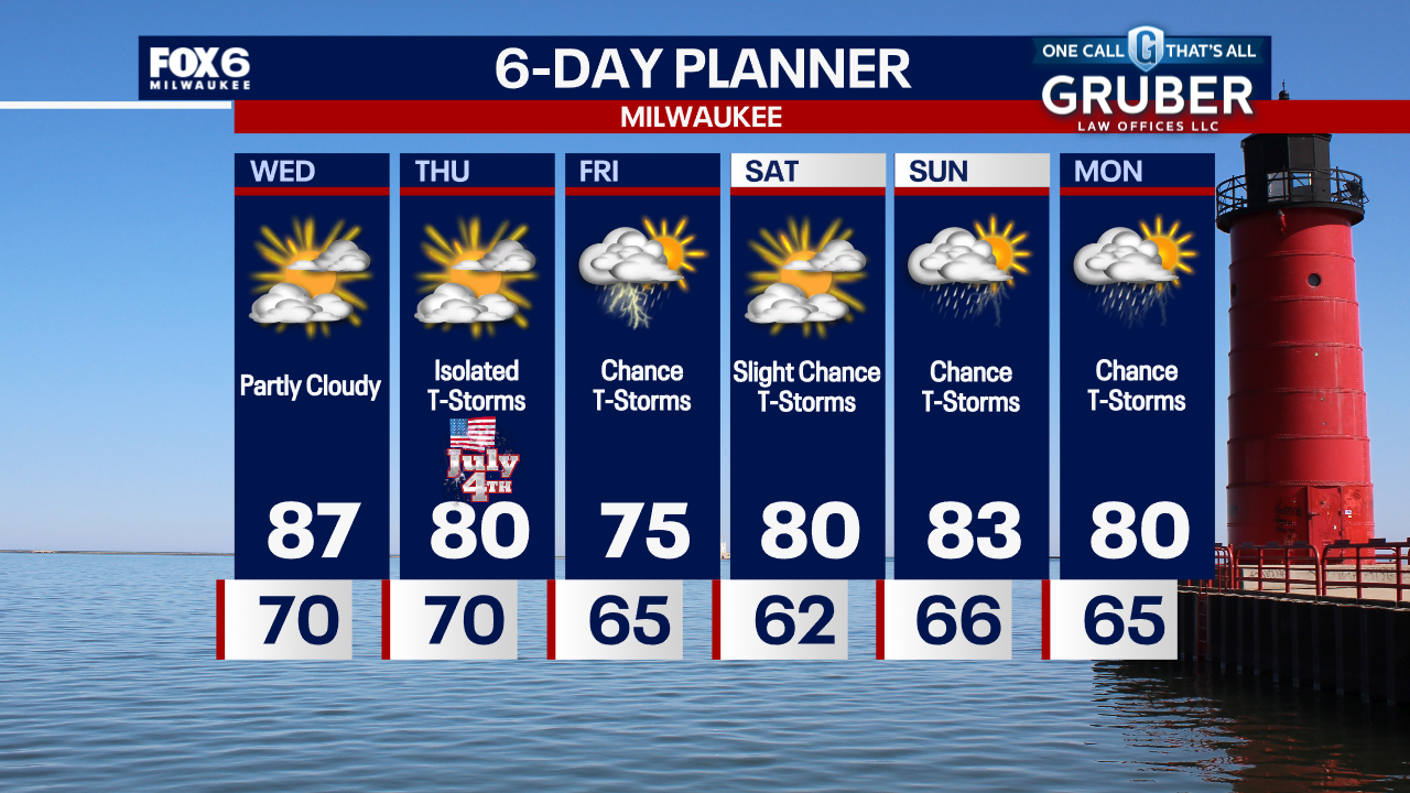
After a few early morning showers, we dry up and clear to partly sunny this afternoon. Hot and humid air arrives on a west wind with highs reaching the upper 80s and dewpoints well into the 60s. We should be dry most of the day on Thursday for Independence Day celebrations but late evening and overnight rain and thunderstorms return. Rain is likely for Friday with a chance for thunderstorms but we should dry up for Saturday.
After a few early morning showers, we dry up and clear to partly sunny this afternoon. Hot and humid air arrives on a west wind with highs reaching the upper 80s and dewpoints well into the 60s. We should be dry most of the day on Thursday for Independence Day celebrations but late evening and overnight rain and thunderstorms return. Rain is likely for Friday with a chance for thunderstorms but we should dry up for Saturday.
Weather Webcast with Chief Meteorologist Tom Wachs
Showers and a few t-storms with heavy rain overnight. Rain ends around 5am. Partly sunny, warm and humid on Wednesday with highs in the mid-to-upper 80s.
Showers and a few t-storms with heavy rain overnight. Rain ends around 5am. Partly sunny, warm and humid on Wednesday with highs in the mid-to-upper 80s.
Weather Webcast with Chief Meteorologist Tom Wachs
Rain and a few rumbles will return after 8-9pm and end between 5-6am. Some heavy rain possible. Partly sunny, warm and humid on Wednesday with highs in the upper 80s.
Rain and a few rumbles will return after 8-9pm and end between 5-6am. Some heavy rain possible. Partly sunny, warm and humid on Wednesday with highs in the upper 80s.

Weather Webcast with Stephanie Barichello
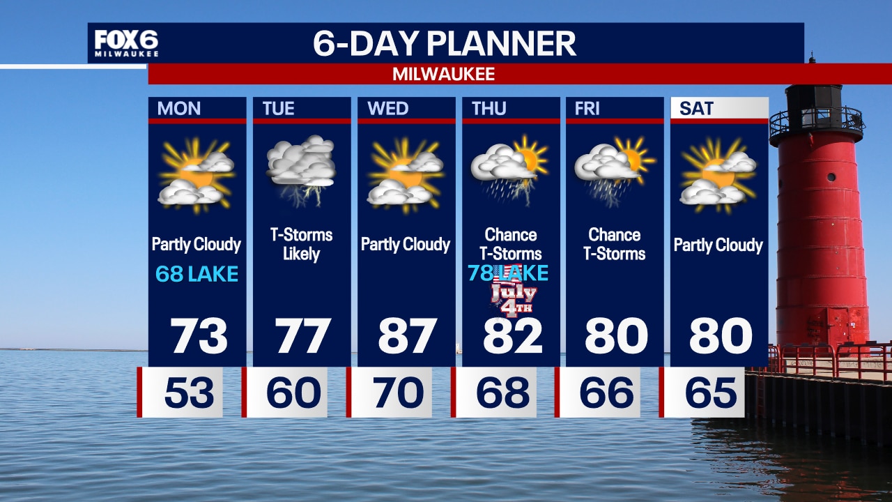
Scattered showers continue this afternoon, then a heavy batch of rain moves through late tonight into early Wednesday morning. Warmer and more humid tomorrow, then there is a slight chance for a few storms for the 4th of July. Better chance for rain will be late Thursday night into Friday.
Scattered showers continue this afternoon, then a heavy batch of rain moves through late tonight into early Wednesday morning. Warmer and more humid tomorrow, then there is a slight chance for a few storms for the 4th of July. Better chance for rain will be late Thursday night into Friday.
Weather webcast with Rob Haswell
An area of low pressure moves from Iowa into the Upper Peninsula of Michigan over the next 24 hours bringing periods of rain and thunderstorms. The biggest threat from this system is heavy rain. It is possible that some areas could exceed an inch or more of rain with even higher values if thunderstorms "train" over the same area.
An area of low pressure moves from Iowa into the Upper Peninsula of Michigan over the next 24 hours bringing periods of rain and thunderstorms. The biggest threat from this system is heavy rain. It is possible that some areas could exceed an inch or more of rain with even higher values if thunderstorms "train" over the same area.
Weather Webcast with Chief Meteorologist Tom Wachs
Rain moves in overnight and continues on Tuesday. Moderate rain at times, especially in the morning and again later in the evening. Windy with highs in the low 70s.
Rain moves in overnight and continues on Tuesday. Moderate rain at times, especially in the morning and again later in the evening. Windy with highs in the low 70s.

Weather Webcast with Chief Meteorologist Tom Wachs
Increasing clouds tonight with rain moving in overnight. Temperatures in the 60s. Rainy with some storms on Tuesday. Windy with highs in the low 70s.
Increasing clouds tonight with rain moving in overnight. Temperatures in the 60s. Rainy with some storms on Tuesday. Windy with highs in the low 70s.

Weather webcast with Rob Haswell
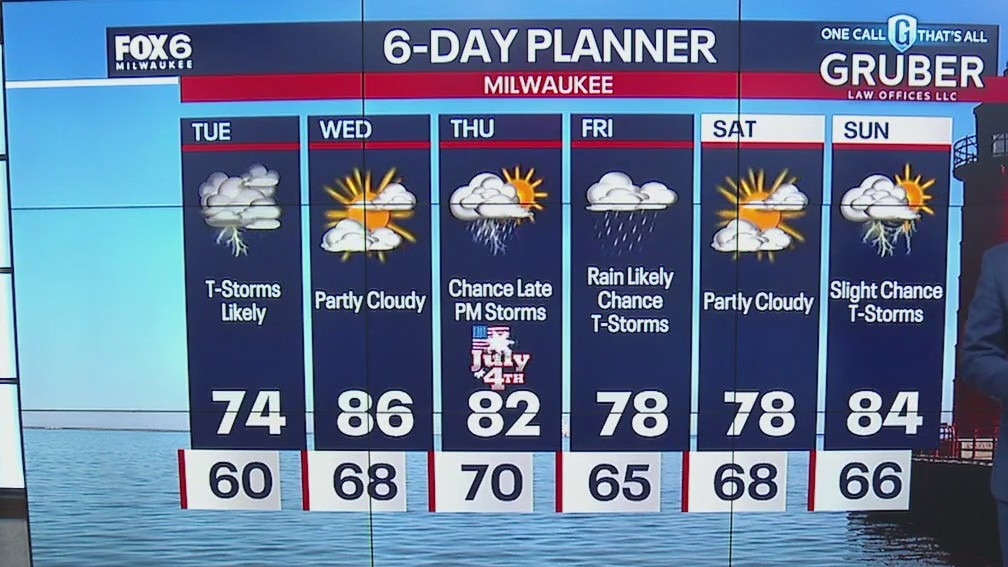
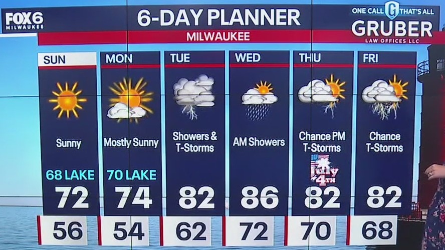
High pressure moves east of us today but hangs on long enough to give us another sunny and dry day. High will be slightly warmer than yesterday. A strengthening low will arrive on Tuesday with more rain and thunderstorms. There is a Marginal Risk for severe storms in areas to our west. There is a chance for showers on Independence Day Thursday. But still ample opportunity to go out and enjoy the day. More rain and thunderstorms Friday and just a slight chance Saturday. We warm to the mid to upper 80s Wednesday but cool to near 80 Thursday through Saturday.
High pressure moves east of us today but hangs on long enough to give us another sunny and dry day. High will be slightly warmer than yesterday. A strengthening low will arrive on Tuesday with more rain and thunderstorms. There is a Marginal Risk for severe storms in areas to our west. There is a chance for showers on Independence Day Thursday. But still ample opportunity to go out and enjoy the day. More rain and thunderstorms Friday and just a slight chance Saturday. We warm to the mid to upper 80s Wednesday but cool to near 80 Thursday through Saturday.

Weather Webcast with Chief Meteorologist Tom Wachs
Clear skies overnight with temperatures dropping into the 50s. Increasing clouds on Monday with high in the upper 60s near the lake, lower 70s inland.
Clear skies overnight with temperatures dropping into the 50s. Increasing clouds on Monday with high in the upper 60s near the lake, lower 70s inland.
Weather Webcast with Chief Meteorologist Tom Wachs
Clear, crisp and cool tonight. Temperatures dropping into the 50s. Partly sunny on Monday with highs in the upper 60s to low 70s. T-Storms return on Tuesday.
Clear, crisp and cool tonight. Temperatures dropping into the 50s. Partly sunny on Monday with highs in the upper 60s to low 70s. T-Storms return on Tuesday.
Weather webcast with Stephanie Barichello
Sunny and comfortable today with temperatures in the upper 60s lakeside to low 70s inland. Similar conditions Monday, then a chance for thunderstorms returns Tuesday into Wednesday morning.
Sunny and comfortable today with temperatures in the upper 60s lakeside to low 70s inland. Similar conditions Monday, then a chance for thunderstorms returns Tuesday into Wednesday morning.

Weather webcast with Rob Haswell
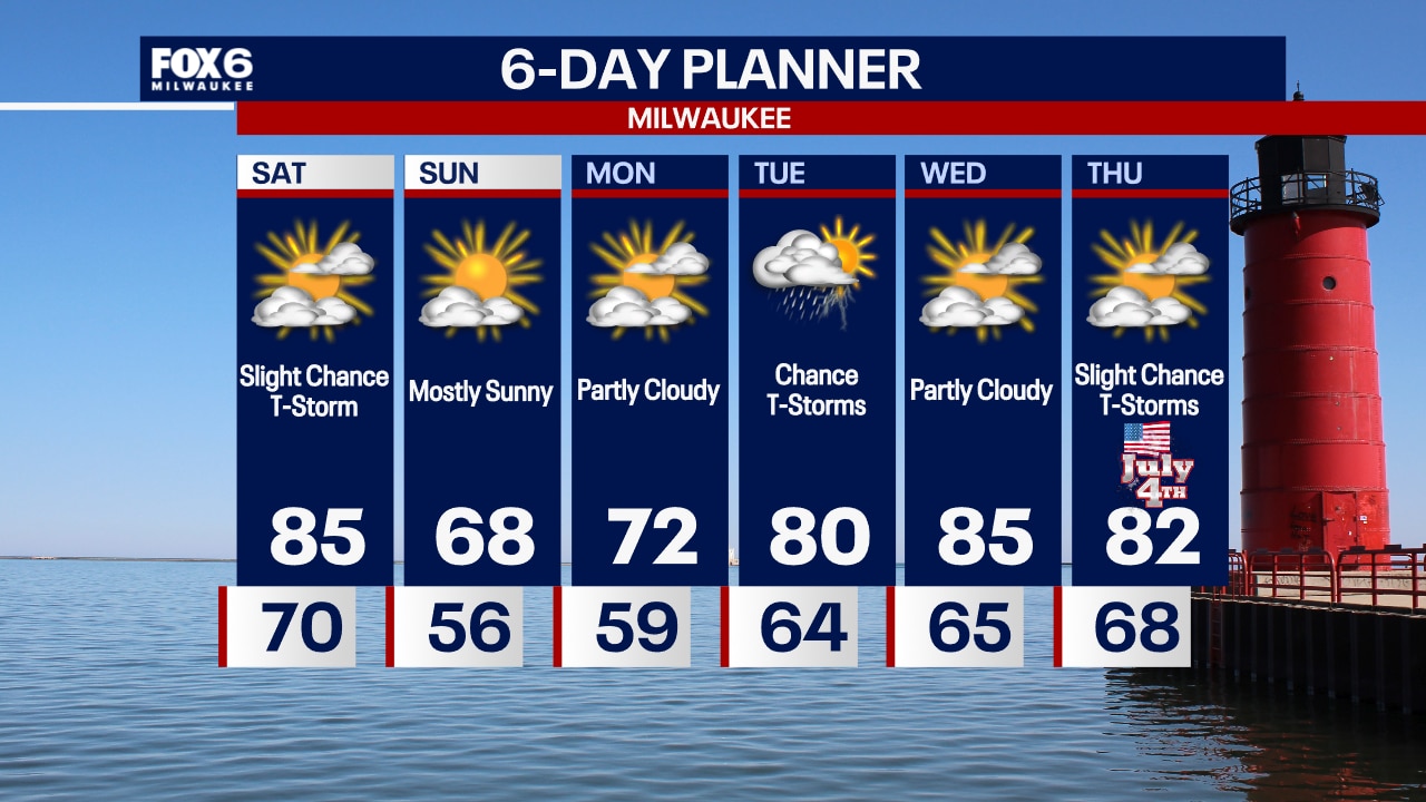
There will be a slight chance for showers at times today but overall a drier day than yesterday. Highs will be in the mid 80s but fall in the later afternoon behind that second cold front. We will cool to the 50s tonight and only get to near 70 Sunday.
There will be a slight chance for showers at times today but overall a drier day than yesterday. Highs will be in the mid 80s but fall in the later afternoon behind that second cold front. We will cool to the 50s tonight and only get to near 70 Sunday.
Weather Webcast with Chief Meteorologist Tom Wachs
Scattered showers and t-storms ending by 6am. Decreasing clouds on Saturday, warm and humid. Highs in the mid-80s. A stray afternoon/evening t-storm is possible.
Scattered showers and t-storms ending by 6am. Decreasing clouds on Saturday, warm and humid. Highs in the mid-80s. A stray afternoon/evening t-storm is possible.

Weather Webcast with Chief Meteorologist Tom Wachs
Scattered showers and t-storms this evening and overnight. Rain ends by 6am with clearing skies throughout the morning. Humid tonight with temperatures in the 70s.
Scattered showers and t-storms this evening and overnight. Rain ends by 6am with clearing skies throughout the morning. Humid tonight with temperatures in the 70s.

Weather webcast with Rob Haswell
Rain and thunderstorms return today with a chance for strong to severe storms at times. Highs will be in the mid 70s and dew points will climb a bit today. Morning showers and storms are expected on Saturday but we should dry up for Saturday afternoon and into Sunday. Another dry day Monday before rain returns Tuesday.
Rain and thunderstorms return today with a chance for strong to severe storms at times. Highs will be in the mid 70s and dew points will climb a bit today. Morning showers and storms are expected on Saturday but we should dry up for Saturday afternoon and into Sunday. Another dry day Monday before rain returns Tuesday.

Weekend Riding Forecast for June 28-30
FOX6's Chief Meteorologist Tom Wachs has your Weekend Riding Forecast for June 28-30, 2024.
FOX6's Chief Meteorologist Tom Wachs has your Weekend Riding Forecast for June 28-30, 2024.
Weather Webcast with Chief Meteorologist Tom Wachs
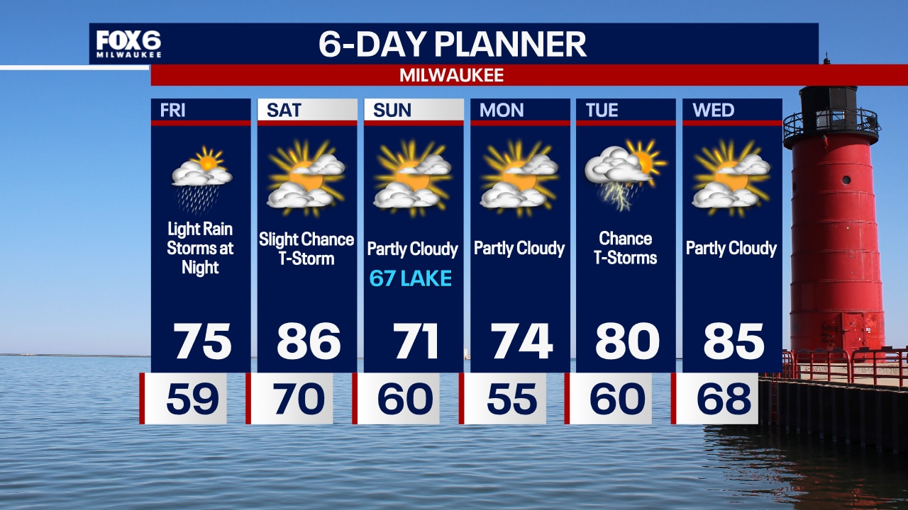
A few light rain showers are possible overnight with temperatures dropping into the 50s. Off-and-on light rain during the day on Friday with highs in the 70s. A few t-storms are possible Friday night.
A few light rain showers are possible overnight with temperatures dropping into the 50s. Off-and-on light rain during the day on Friday with highs in the 70s. A few t-storms are possible Friday night.


Daily Forecast Update
A cold front moves into the area later today but ahead of that, we remain hot and sticky with highs in the upper 80s and dew points near 70.
A cold front moves into the area later today but ahead of that, we remain hot and sticky with highs in the upper 80s and dew points near 70.