


Weather webcast with Lisa Michaels
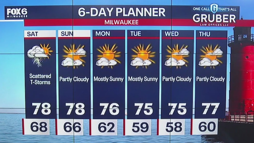
Partly cloudy skies on Sunday with highs in the upper 70s. Slightly less humid. An isolated shower or two possible closer to the lake if a lake breeze sets up Sunday. Another long dry stretch next week.
Partly cloudy skies on Sunday with highs in the upper 70s. Slightly less humid. An isolated shower or two possible closer to the lake if a lake breeze sets up Sunday. Another long dry stretch next week.

Weather Webcast with Stephanie Barichello
Showers taper off tonight, then becoming partly sunny on Sunday. We'll likely still wake up to some clouds, possibly a few sprinkles. Sunshine and quiet weather ahead all of next week.
Showers taper off tonight, then becoming partly sunny on Sunday. We'll likely still wake up to some clouds, possibly a few sprinkles. Sunshine and quiet weather ahead all of next week.
Weather webcast with Lisa Michaels
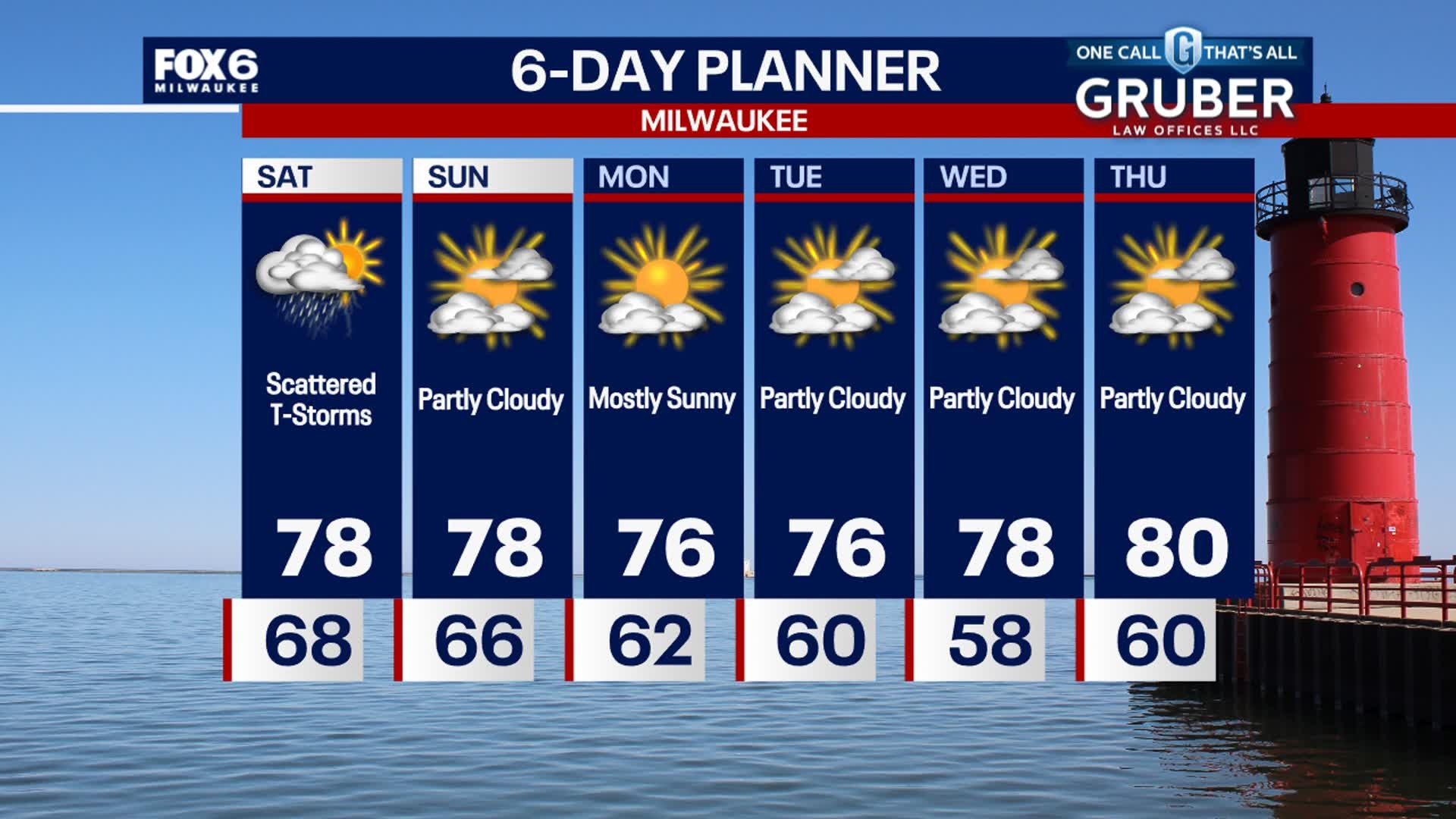
Mostly cloudy and dry the first half of Saturday. Then scattered rain/storms Saturday afternoon which should be non-severe. Temperatures will reach the upper 70s by Saturday afternoon with humid conditions.
Mostly cloudy and dry the first half of Saturday. Then scattered rain/storms Saturday afternoon which should be non-severe. Temperatures will reach the upper 70s by Saturday afternoon with humid conditions.
Weather Webcast with Stephanie Barichello
Scattered thunderstorms with heavy rainfall expected this evening, then another chance for scattered showers and storms on Saturday. Drying out Sunday then very comfortable weather next week.
Scattered thunderstorms with heavy rainfall expected this evening, then another chance for scattered showers and storms on Saturday. Drying out Sunday then very comfortable weather next week.
Weather webcast with Lisa Michaels
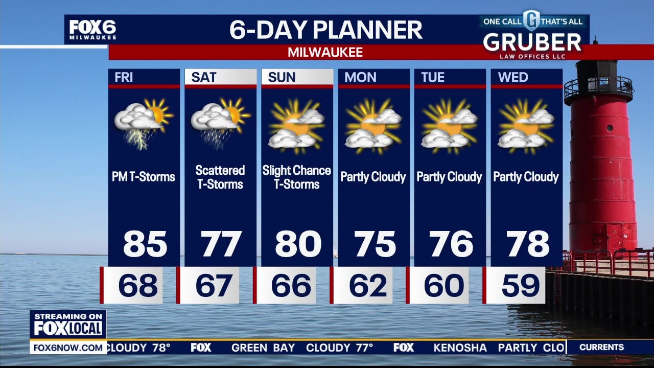
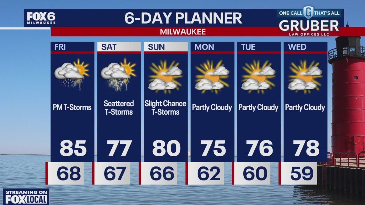
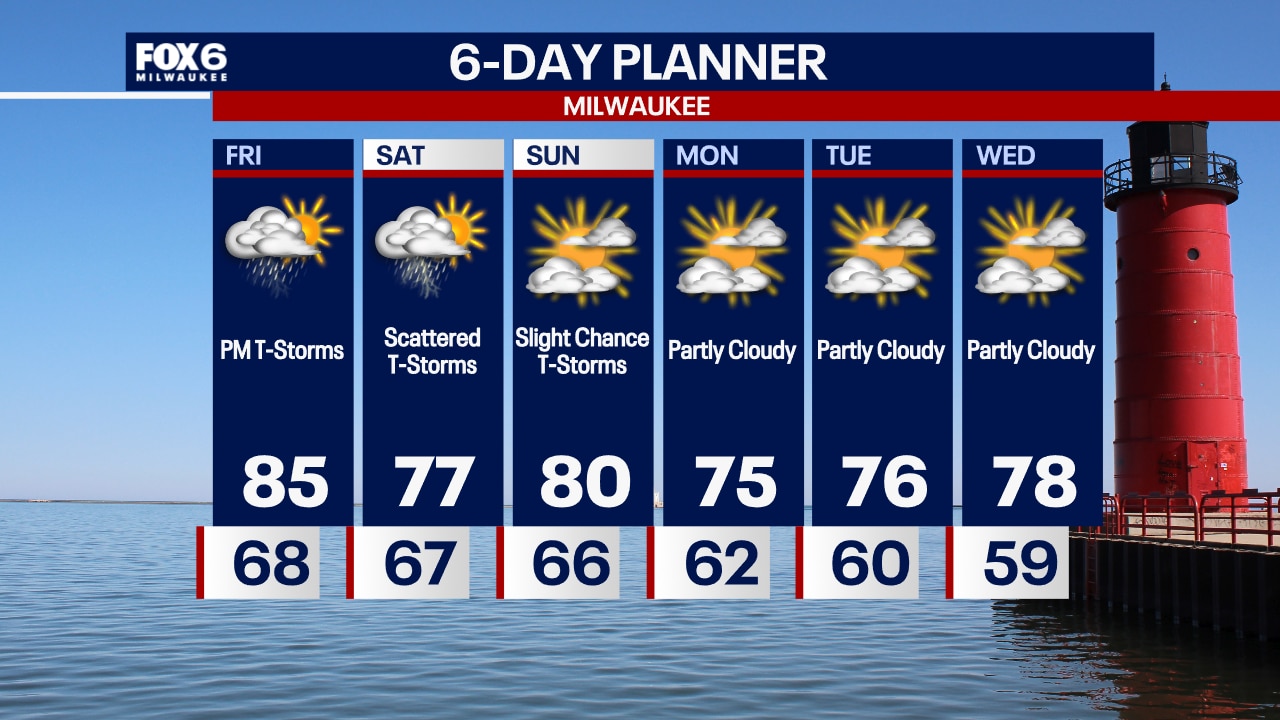
Partly sunny, warm and humid on Friday. Highs in mid-80s. Scattered t-storms are likely on Friday afternoon/early evening. A few could be strong to severe with wind/hail/heavy rain. Partly sunny and cooler on Saturday, but still humid. Scattered thunderstorms are possible on Saturday, especially in the afternoon & evening. Highs in the upper 70s. Partly sunny with a slight chance for a t-storm on Sunday. Warmer and less humid with highs around 80.
Partly sunny, warm and humid on Friday. Highs in mid-80s. Scattered t-storms are likely on Friday afternoon/early evening. A few could be strong to severe with wind/hail/heavy rain. Partly sunny and cooler on Saturday, but still humid. Scattered thunderstorms are possible on Saturday, especially in the afternoon & evening. Highs in the upper 70s. Partly sunny with a slight chance for a t-storm on Sunday. Warmer and less humid with highs around 80.
Weather webcast with Lisa Michaels
Fog early Friday morning. Partly sunny, warm and humid on Friday. Highs in mid-80s. Scattered t-storms are likely on Friday afternoon/early evening. A few could be strong to severe with wind/hail/heavy rain. Partly sunny and cooler on Saturday, but still humid. Scattered thunderstorms are possible on Saturday, especially in the afternoon & evening. Highs in the upper 70s. Partly sunny with a slight chance for a t-storm on Sunday. Warmer and less humid with highs around 80.
Fog early Friday morning. Partly sunny, warm and humid on Friday. Highs in mid-80s. Scattered t-storms are likely on Friday afternoon/early evening. A few could be strong to severe with wind/hail/heavy rain. Partly sunny and cooler on Saturday, but still humid. Scattered thunderstorms are possible on Saturday, especially in the afternoon & evening. Highs in the upper 70s. Partly sunny with a slight chance for a t-storm on Sunday. Warmer and less humid with highs around 80.
Weather Webcast with Chief Meteorologist Tom Wachs
Foggy overnight with a few t-storms possible. Humid with temperatures in the 60s. Warm and humid on Friday with strong t-storms possible during the afternoon. Highs in the mid-80s.
Foggy overnight with a few t-storms possible. Humid with temperatures in the 60s. Warm and humid on Friday with strong t-storms possible during the afternoon. Highs in the mid-80s.

Weather Webcast with Chief Meteorologist Tom Wachs
Drizzle and light rain this evening with a chance for t-storms around midnight. Steady temperatures in the upper 60s. Partly sunny, warm and humid on Friday with afternoon severe t-storms possible.
Drizzle and light rain this evening with a chance for t-storms around midnight. Steady temperatures in the upper 60s. Partly sunny, warm and humid on Friday with afternoon severe t-storms possible.

Weather Webcast with Stephanie Barichello
Rain showers should become more scattered this afternoon and evening, but thunderstorms will also be possible as the days goes on. Another round of storms expected Friday afternoon and evening, possibly severe, then beginning to dry out over the weekend. A few showers and storms will still be possible on Saturday.
Rain showers should become more scattered this afternoon and evening, but thunderstorms will also be possible as the days goes on. Another round of storms expected Friday afternoon and evening, possibly severe, then beginning to dry out over the weekend. A few showers and storms will still be possible on Saturday.
Weather Webcast with Stephanie Barichello
Scattered showers and storms expected this afternoon and evening, then another round of storms expected Friday afternoon. A few showers may linger into Saturday then drying out the rest of the weekend. Sunshine early next week.
Scattered showers and storms expected this afternoon and evening, then another round of storms expected Friday afternoon. A few showers may linger into Saturday then drying out the rest of the weekend. Sunshine early next week.

Weather webcast with Rob Haswell
A strong low is moving through the region today with periods of rain and thunderstorms. There is a risk for strong to severe storms as well as periods of heavy rain today. Temperatures will be flat most of the day with highs in the low to mid 70 and staying in the upper 60s to near 70 overnight. More showers and isolated thunderstorms on Friday and a few on Saturday. Highs will warm to the upper 70s and near 80. We should dry up Sunday and into early next week.
A strong low is moving through the region today with periods of rain and thunderstorms. There is a risk for strong to severe storms as well as periods of heavy rain today. Temperatures will be flat most of the day with highs in the low to mid 70 and staying in the upper 60s to near 70 overnight. More showers and isolated thunderstorms on Friday and a few on Saturday. Highs will warm to the upper 70s and near 80. We should dry up Sunday and into early next week.

Weather Webcast with Chief Meteorologist Tom Wachs
Light rain overnight really picking up throughout the morning. Temperatures in the 60s. Rainy and windy on Thursday with highs in the low-to-mid 70s.
Light rain overnight really picking up throughout the morning. Temperatures in the 60s. Rainy and windy on Thursday with highs in the low-to-mid 70s.

Weather Webcast with Chief Meteorologist Tom Wachs
Increasing clouds tonight with rain moving in overnight. Temperatures dropping into the 60s. Very rainy on Thursday morning with a break in the rain later in the afternoon. Windy with highs in the low 70s.
Increasing clouds tonight with rain moving in overnight. Temperatures dropping into the 60s. Very rainy on Thursday morning with a break in the rain later in the afternoon. Windy with highs in the low 70s.

Weather Webcast with Stephanie Barichello
Increasing clouds later today, then steady rain expected overnight into about midday Thursday. Rain may be heavy at times. Scattered storms are then possible the rest of the day, potentially severe. Scattered storms are also possible Friday, then drying out over the weekend.
Increasing clouds later today, then steady rain expected overnight into about midday Thursday. Rain may be heavy at times. Scattered storms are then possible the rest of the day, potentially severe. Scattered storms are also possible Friday, then drying out over the weekend.

Weather webcast with Rob Haswell
Patchy dense fog this morning with a Dense Fog Advisory in place for most of SE Wisconsin until 8am. Drive with care. A Beach Hazards Statement is also in place today - stay out of Lake Michigan. Partly sunny to start then more clouds later today. Highs will be in the low 80s with slightly higher dew points for a more humid feel to the day. Showers arrive overnight with periods of rain and thunderstorms likely for Thursday. Heavy rain is expected at times. More showers Friday and parts of Saturday but we clear up nicely early next week.
Patchy dense fog this morning with a Dense Fog Advisory in place for most of SE Wisconsin until 8am. Drive with care. A Beach Hazards Statement is also in place today - stay out of Lake Michigan. Partly sunny to start then more clouds later today. Highs will be in the low 80s with slightly higher dew points for a more humid feel to the day. Showers arrive overnight with periods of rain and thunderstorms likely for Thursday. Heavy rain is expected at times. More showers Friday and parts of Saturday but we clear up nicely early next week.
Weather Webcast with Chief Meteorologist Tom Wachs
Areas of dense fog possible overnight with temperatures in the 60s. Increasing clouds on Wednesday with highs in the upper 70s to low 80s. Rain returns on Thursday.
Areas of dense fog possible overnight with temperatures in the 60s. Increasing clouds on Wednesday with highs in the upper 70s to low 80s. Rain returns on Thursday.

Weather Webcast with Chief Meteorologist Tom Wachs
Mostly clear and quiet tonight. Temperatures dropping into the 60s. Increasing clouds on Wednesday with highs in the upper 70s to low 80s. Rain returns on Thursday.
Mostly clear and quiet tonight. Temperatures dropping into the 60s. Increasing clouds on Wednesday with highs in the upper 70s to low 80s. Rain returns on Thursday.

Weather Webcast with Stephanie Barichello
A mix of clouds and sun this afternoon with a stray pop-up shower along the lake breeze. Highs reach into the 80s. Similar Wednesday then expect a rainy Thursday. Scattered thunderstorms will also be possible on Friday. Mainly dry this weekend.
A mix of clouds and sun this afternoon with a stray pop-up shower along the lake breeze. Highs reach into the 80s. Similar Wednesday then expect a rainy Thursday. Scattered thunderstorms will also be possible on Friday. Mainly dry this weekend.

Weather webcast with Rob Haswell
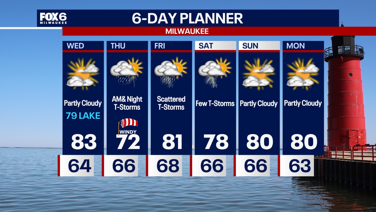
High pressure once again plays the lead role in our forecast keeping us sunny and dry. Highs will be in the low 80s and dew points will break the low 60s. Another dry day on the way tomorrow with seasonal temperatures but then the rain arrives. Heavy rain is possible at times on Thursday with two inches or more possible from Thursday into early Friday. We continue to see at least a chance for rain through the weekend.
High pressure once again plays the lead role in our forecast keeping us sunny and dry. Highs will be in the low 80s and dew points will break the low 60s. Another dry day on the way tomorrow with seasonal temperatures but then the rain arrives. Heavy rain is possible at times on Thursday with two inches or more possible from Thursday into early Friday. We continue to see at least a chance for rain through the weekend.
Weather webcast with Lisa Michaels
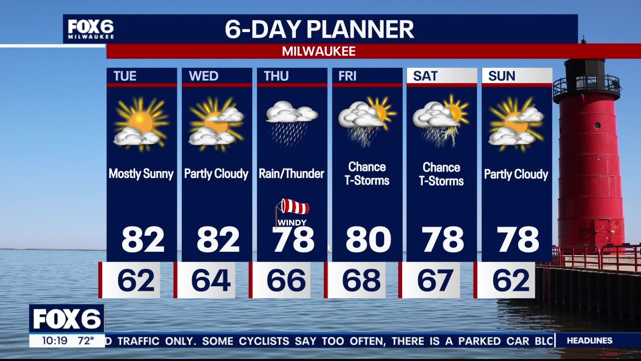
More seasonable temps this week in the low 80s. High pressure keeps us dry for the first half of the week through Wednesday. We are mostly dry today through Wednesday afternoon but then enter a soggy period from Wednesday night through the weekend. We could see 1.5 - 2.0 inches of rain over a few days later this week.
More seasonable temps this week in the low 80s. High pressure keeps us dry for the first half of the week through Wednesday. We are mostly dry today through Wednesday afternoon but then enter a soggy period from Wednesday night through the weekend. We could see 1.5 - 2.0 inches of rain over a few days later this week.