

Weather Webcast with Holly Baker
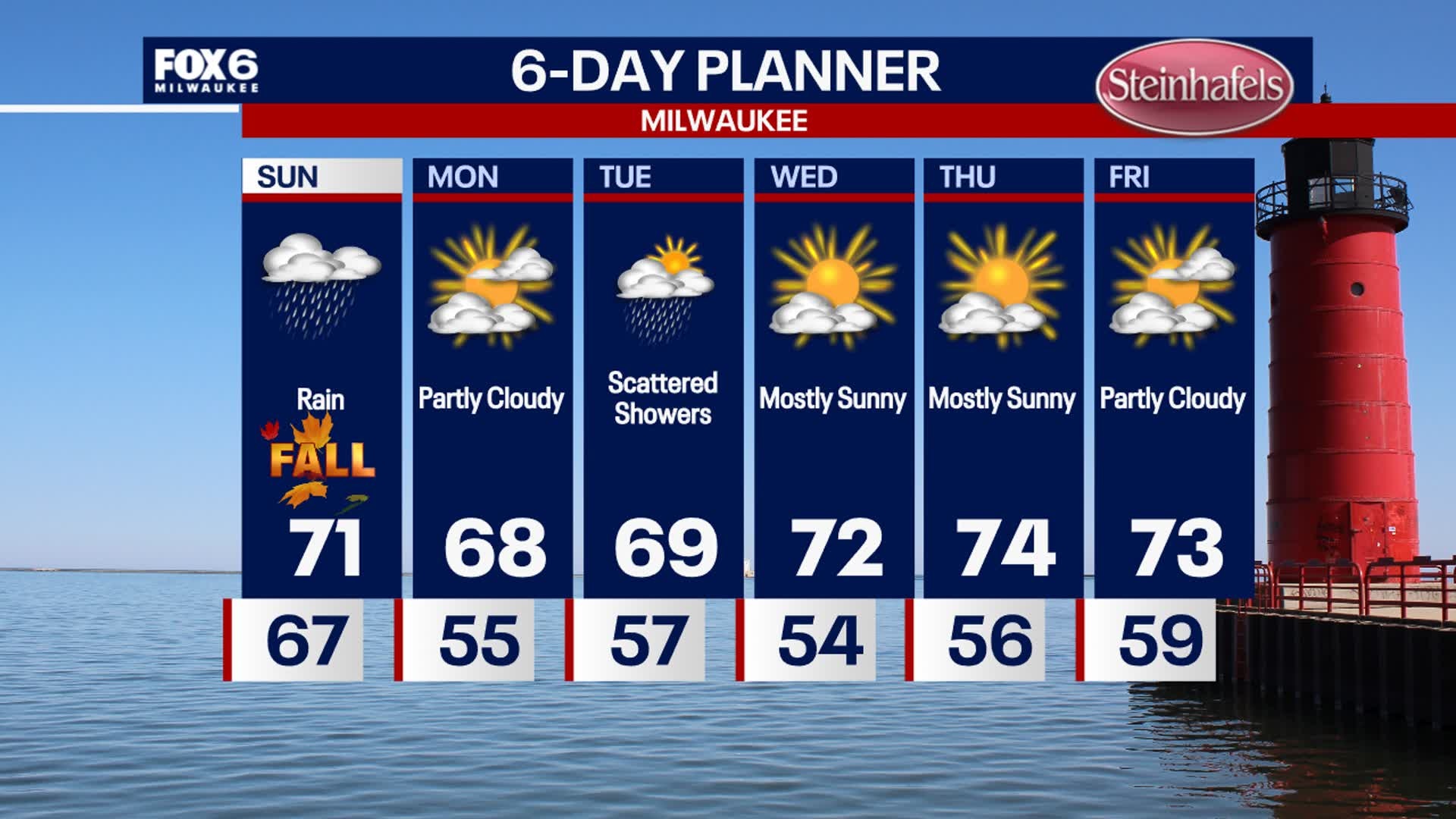
More rain is on the way with fall-like temperatures arriving.
More rain is on the way with fall-like temperatures arriving.
Weather webcast with Lisa Michaels
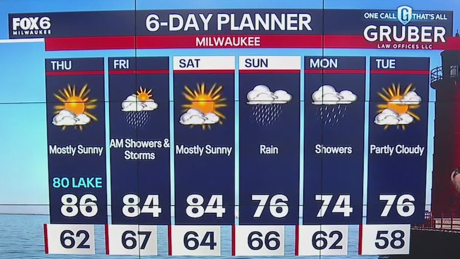
Summer-like Saturday with partly sunny skies and temps warming into the upper 80s inland and low 80s near the lake. Rain and storms possible by Saturday evening due to the passing of a cold front.
Summer-like Saturday with partly sunny skies and temps warming into the upper 80s inland and low 80s near the lake. Rain and storms possible by Saturday evening due to the passing of a cold front.

Weather webcast with Meteorologist Holly Baker
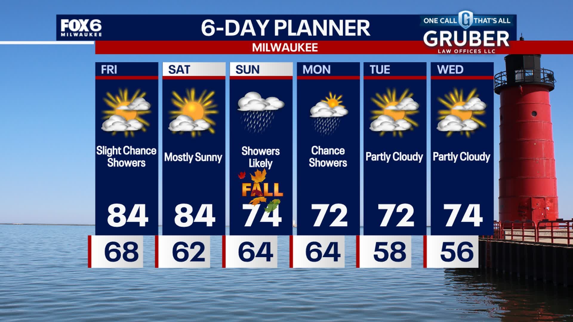
The weather will be quiet tonight and sunny for the start of Saturday. More rain is likely Saturday evening. Showers possible on Sunday.
The weather will be quiet tonight and sunny for the start of Saturday. More rain is likely Saturday evening. Showers possible on Sunday.

Weather webcast with Stephanie Barichello
Clear skies tonight with temperatures falling into the 50s and low 60s by morning. One more summer-like day Saturday before temperatures drop. Highs will reach into the middle and upper 80s, and only slightly cooler lakeside.
Clear skies tonight with temperatures falling into the 50s and low 60s by morning. One more summer-like day Saturday before temperatures drop. Highs will reach into the middle and upper 80s, and only slightly cooler lakeside.
Weather webcast with Rob Haswell
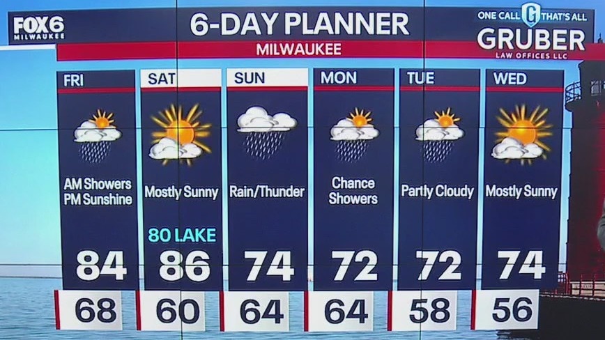
An area of low pressure rotates its fronts through our area today with the rain ending by late morning and sun returning for the afternoon. We won't cool noticeably behind this system with high temperatures again in the low to mid 80s.
An area of low pressure rotates its fronts through our area today with the rain ending by late morning and sun returning for the afternoon. We won't cool noticeably behind this system with high temperatures again in the low to mid 80s.
Weather Webcast with Stephanie Barichello
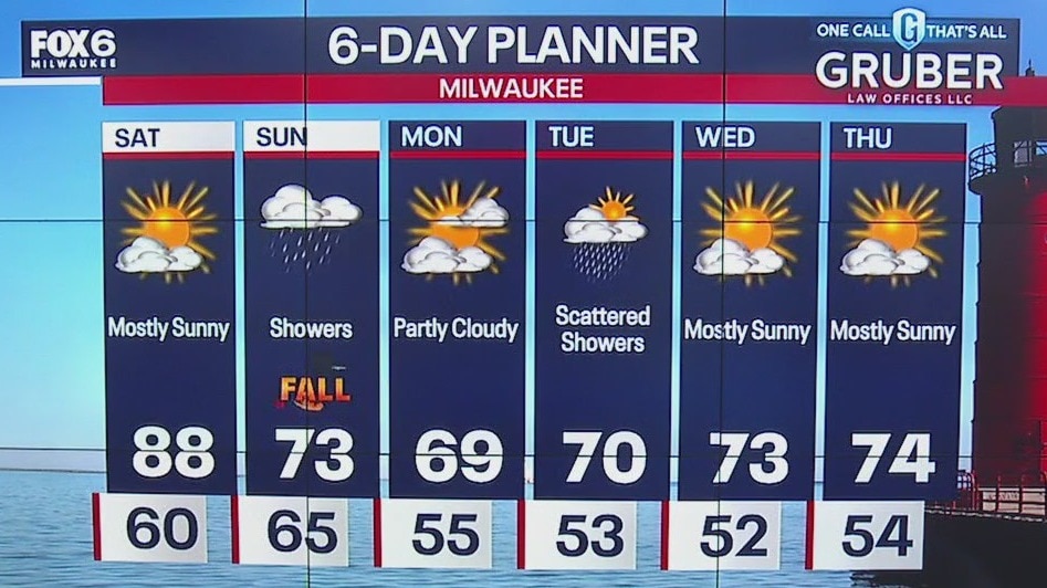
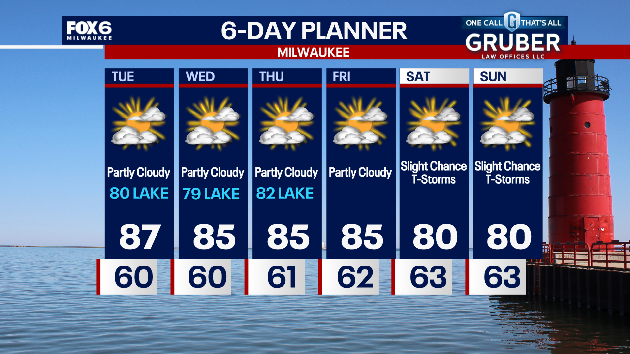
Showers and thunderstorms expected overnight, then drying out Friday and Saturday. A more beneficial rain arrives Sunday into Monday, and temperatures will drop to near normal numbers!
Showers and thunderstorms expected overnight, then drying out Friday and Saturday. A more beneficial rain arrives Sunday into Monday, and temperatures will drop to near normal numbers!
Weather Webcast with Stephanie Barichello
Showers and storms expected late tonight into Friday morning, then more sunshine on Friday. It'll be a warm and humid day. Sunny to start the weekend then rain returns Sunday and Monday. Temperatures will be near normal in the 70s starting Sunday.
Showers and storms expected late tonight into Friday morning, then more sunshine on Friday. It'll be a warm and humid day. Sunny to start the weekend then rain returns Sunday and Monday. Temperatures will be near normal in the 70s starting Sunday.
Weather webcast with Rob Haswell
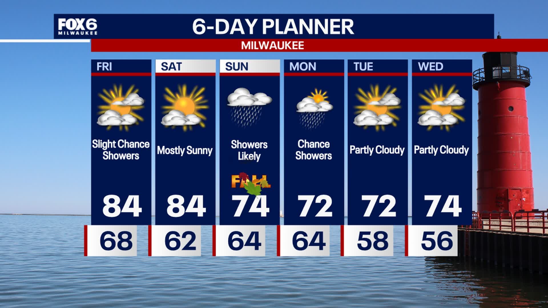
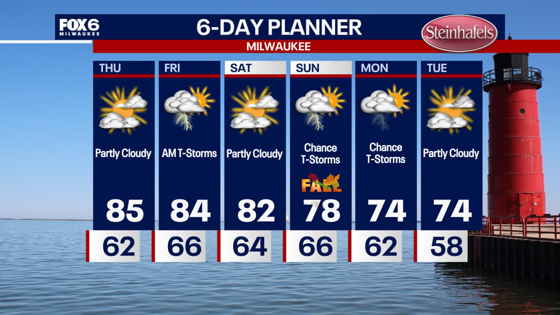
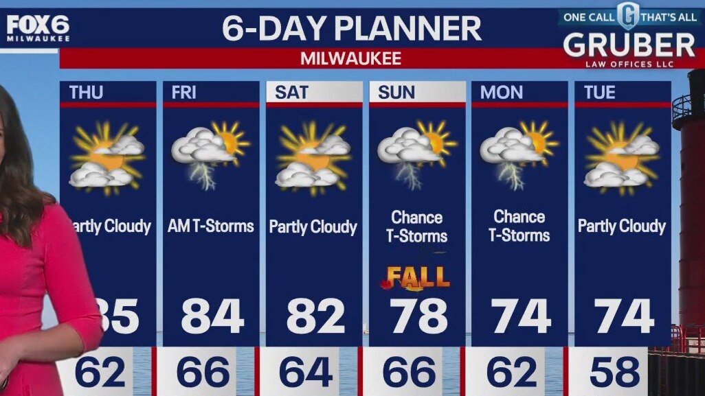
We start with ample sun again today but get a bit cloudier late in the day with a chance of showers and thunderstorms overnight into Friday morning. Highs will reach the low to mid 80s inland today with upper 70s and low 80s closer to Lake Michigan.
We start with ample sun again today but get a bit cloudier late in the day with a chance of showers and thunderstorms overnight into Friday morning. Highs will reach the low to mid 80s inland today with upper 70s and low 80s closer to Lake Michigan.
Weather Webcast with Stephanie Barichello
Warm Thursday with temperatures in the middle 80s, then a chance for rain and thunder Thursday night into Friday morning. A few more chances for storms Sunday into Monday, and temperatures will drop closer to normal next week.
Warm Thursday with temperatures in the middle 80s, then a chance for rain and thunder Thursday night into Friday morning. A few more chances for storms Sunday into Monday, and temperatures will drop closer to normal next week.
Weather webcast with Stephanie Barichello
Clear skies tonight with temperatures falling into the 50s and low 60s. Patchy fog will once again be possible in spots. Sunny again Thursday with more clouds in the afternoon. Temperatures will reach into the middle 80s.
Clear skies tonight with temperatures falling into the 50s and low 60s. Patchy fog will once again be possible in spots. Sunny again Thursday with more clouds in the afternoon. Temperatures will reach into the middle 80s.
Weather webcast with Lisa Michaels
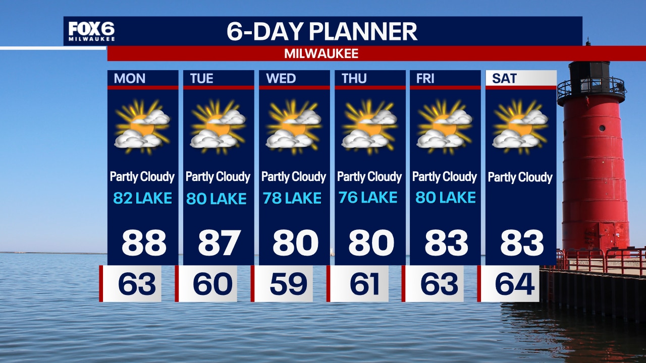
Highs will warm to the mid 80s inland and upper 70s to low 80s closer to Lake Michigan. We stay dry and hot for Thursday but showers and a chance for thunderstorms arrive overnight into Friday. We then dry up again for most of Saturday but rain showers are possible with a chance for thunderstorms on Sunday.
Highs will warm to the mid 80s inland and upper 70s to low 80s closer to Lake Michigan. We stay dry and hot for Thursday but showers and a chance for thunderstorms arrive overnight into Friday. We then dry up again for most of Saturday but rain showers are possible with a chance for thunderstorms on Sunday.
Weather webcast with Rob Haswell
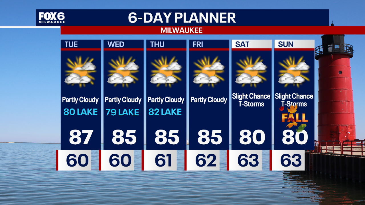
Patchy fog again this morning then hazy sunshine. Highs will warm to the mid 80s inland and upper 70s to low 80s closer to Lake Michigan.
Patchy fog again this morning then hazy sunshine. Highs will warm to the mid 80s inland and upper 70s to low 80s closer to Lake Michigan.

Weather Webcast with Chief Meteorologist Tom Wachs
Mostly clear with areas of fog overnight. Temperatures dropping into the 50s. Mostly sunny and warm again on Wednesday. Highs in the 80s. Rain chances return on Friday.
Mostly clear with areas of fog overnight. Temperatures dropping into the 50s. Mostly sunny and warm again on Wednesday. Highs in the 80s. Rain chances return on Friday.
Weather webcast from Rob Haswell
Another day with hazy sunshine and well above average heat. Highs will get into the mid to upper 80s inland and low 80s lakeside.
Another day with hazy sunshine and well above average heat. Highs will get into the mid to upper 80s inland and low 80s lakeside.
Weather Webcast with Chief Meteorologist Tom Wachs
Patchy fog overnight with temperatures in the upper 50s to low 60s by sunrise. Partly sunny and warm again on Tuesday. Highs in the mid-to-upper 80s inland, around 80 near the lake.
Patchy fog overnight with temperatures in the upper 50s to low 60s by sunrise. Partly sunny and warm again on Tuesday. Highs in the mid-to-upper 80s inland, around 80 near the lake.
Weather Webcast with Chief Meteorologist Tom Wachs
Partly cloudy this evening with patchy fog overnight. Temperatures dropping into the 60s. Partly sunny and warm again on Tuesday. Highs in the mid-to-upper 80s inland, low 80s near the lake.
Partly cloudy this evening with patchy fog overnight. Temperatures dropping into the 60s. Partly sunny and warm again on Tuesday. Highs in the mid-to-upper 80s inland, low 80s near the lake.
Weather Webcast with Stephanie Barichello
More sunshine and 80s on the way this week. Enjoy!
More sunshine and 80s on the way this week. Enjoy!
Weather webcast with Rob Haswell
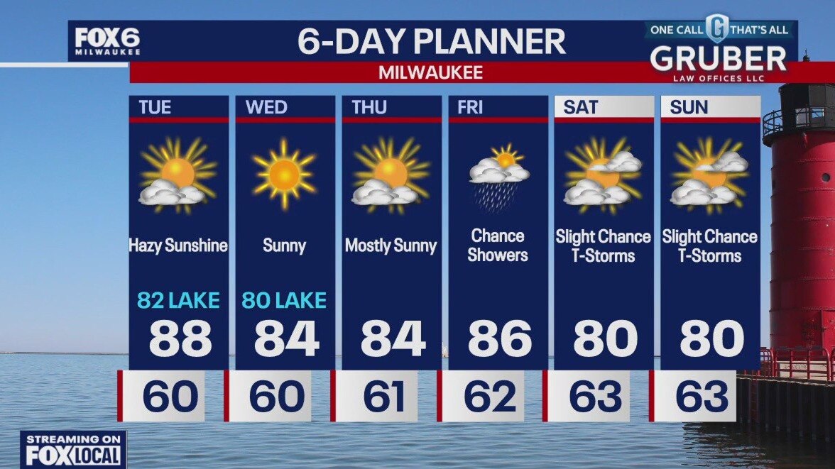
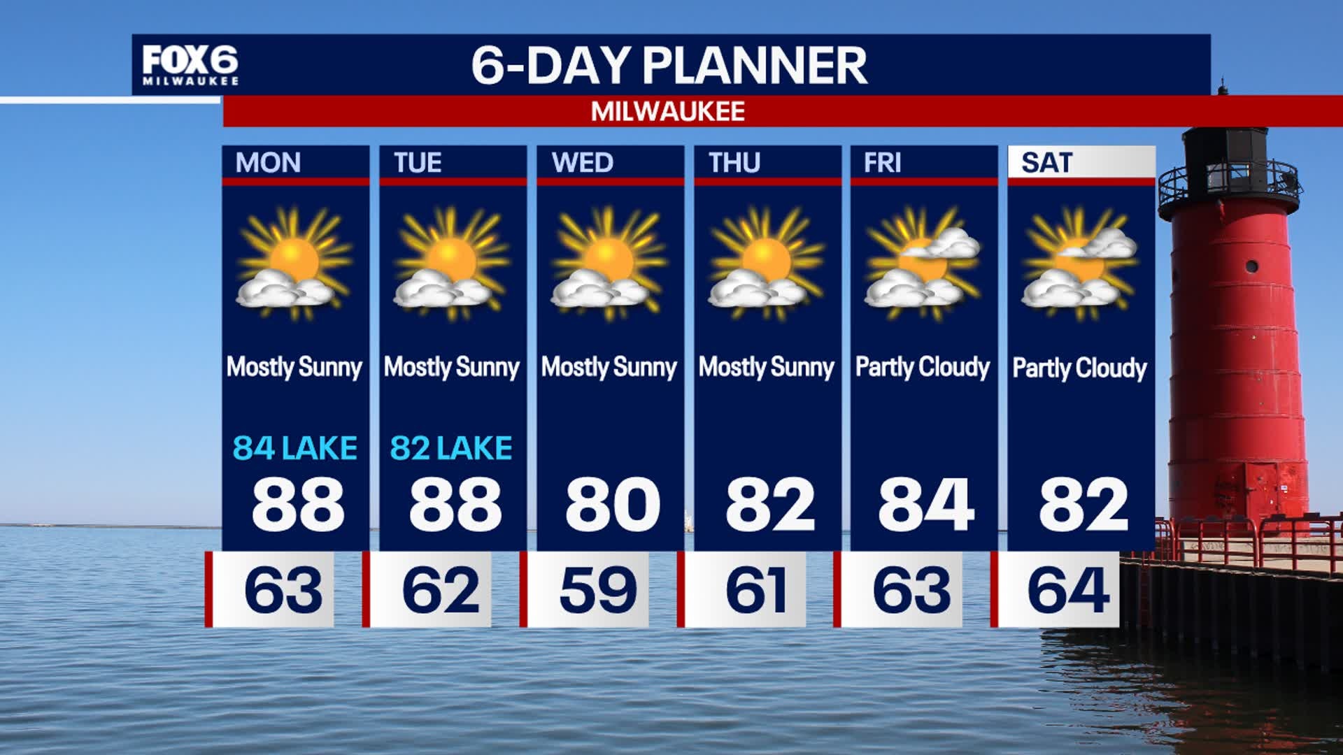
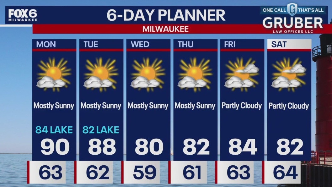
Some patchy fog early this morning, then mostly sunny and hot again today. Highs will be in the upper 80s to near 90 inland and in the low 80s even lakeside with a southeast wind most of the day.
Some patchy fog early this morning, then mostly sunny and hot again today. Highs will be in the upper 80s to near 90 inland and in the low 80s even lakeside with a southeast wind most of the day.
Weather Webcast with Chief Meteorologist Tom Wachs
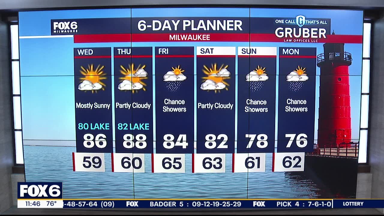
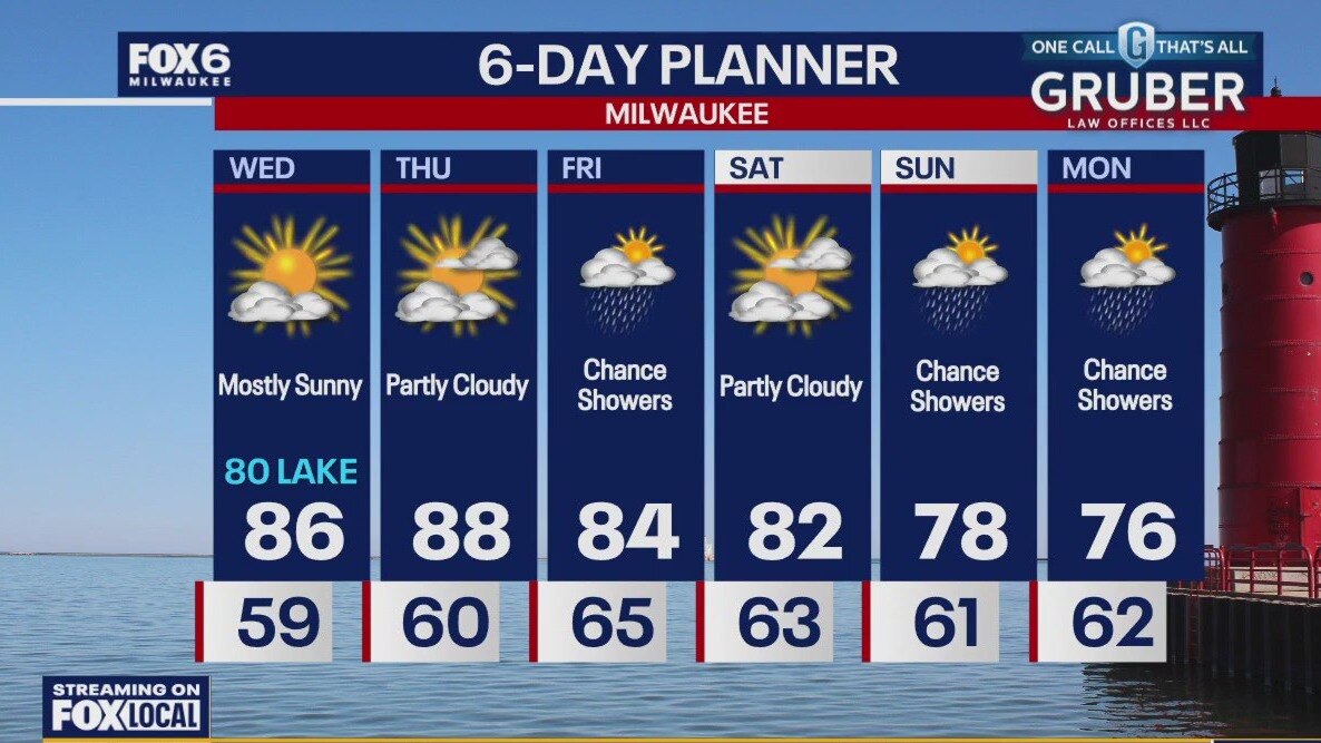
Patchy dense fog overnight with temperatures in the 60s. Partly sunny and warm again on Monday. Highs in the upper 80s inland, lower 80s near the lake. More warm weather throughout the week with highs in the 80s.
Patchy dense fog overnight with temperatures in the 60s. Partly sunny and warm again on Monday. Highs in the upper 80s inland, lower 80s near the lake. More warm weather throughout the week with highs in the 80s.

Weather Webcast with Chief Meteorologist Tom Wachs
Mostly clear tonight with temperatures dropping into the 60s. Patchy dense fog overnight. Another warm day on Monday with highs in the upper 80s inland, low 80s near the lake. More summer-like weather throughout the week.
Mostly clear tonight with temperatures dropping into the 60s. Patchy dense fog overnight. Another warm day on Monday with highs in the upper 80s inland, low 80s near the lake. More summer-like weather throughout the week.