


Weather webcast with Rob Haswell
Another mostly quiet day today but as a front passes later tonight we may see a few sprinkles. Highs will again be well above average hitting the low to mid 70s inland but cooler near the lake as a NE wind develops in the afternoon. Any overnight showers will wrap up very early Friday morning and then we return to sun for Friday and most of Saturday before a few more overnight showers into Sunday morning. Weekend highs will be in the low to mid 70s.
Another mostly quiet day today but as a front passes later tonight we may see a few sprinkles. Highs will again be well above average hitting the low to mid 70s inland but cooler near the lake as a NE wind develops in the afternoon. Any overnight showers will wrap up very early Friday morning and then we return to sun for Friday and most of Saturday before a few more overnight showers into Sunday morning. Weekend highs will be in the low to mid 70s.

Weather Webcast with Chief Meteorologist Tom Wachs
Clear skies overnight with temperatures in the 40s to low 50s. Partly sunny on Thursday with highs in the upper 60s near the lake, low 70s inland.
Clear skies overnight with temperatures in the 40s to low 50s. Partly sunny on Thursday with highs in the upper 60s near the lake, low 70s inland.

Weather Webcast with Chief Meteorologist Tom Wachs
Clear skies tonight with temperatures dropping into the 50s. Not as cold tonight as last night. Partly sunny on Thursday with highs in the upper 60s near the lake, low 70s inland.
Clear skies tonight with temperatures dropping into the 50s. Not as cold tonight as last night. Partly sunny on Thursday with highs in the upper 60s near the lake, low 70s inland.

Weather Webcast with Stephanie Barichello
More and more sunshine ahead with temperatures in the low 70s the next couple of days. Another cold front will cool back to 60s Friday and possibly bring a few sprinkles in the morning. A few more sprinkles possible Saturday night.
More and more sunshine ahead with temperatures in the low 70s the next couple of days. Another cold front will cool back to 60s Friday and possibly bring a few sprinkles in the morning. A few more sprinkles possible Saturday night.

Weather webcast with Rob Haswell
High pressure building over our region keeps us sunny and dry for a few days. Highs today will be above the climate average, reaching the low 70s in most areas. With clear conditions overnight, we cool into the 40s and low 50s overnight before the sun helps us return to the 70s Thursday afternoon. The only chance of rain comes Saturday night into early Sunday morning.
High pressure building over our region keeps us sunny and dry for a few days. Highs today will be above the climate average, reaching the low 70s in most areas. With clear conditions overnight, we cool into the 40s and low 50s overnight before the sun helps us return to the 70s Thursday afternoon. The only chance of rain comes Saturday night into early Sunday morning.

Weather Webcast with Chief Meteorologist Tom Wachs
Patchy frost away from the lake overnight. Temperatures dropping into the 40s in most areas, with a few upper 30s inland. Mostly sunny, breezy and warmer on Wednesday with highs around 70.
Patchy frost away from the lake overnight. Temperatures dropping into the 40s in most areas, with a few upper 30s inland. Mostly sunny, breezy and warmer on Wednesday with highs around 70.

Weather Webcast with Chief Meteorologist Tom Wachs
Increasing clouds tonight with temperatures dropping into the 40s overnight. 30s are possible away from the lake, which could lead to patchy frost in the morning. Mostly sunny, breezy and warmer on Wednesday with a high around 70.
Increasing clouds tonight with temperatures dropping into the 40s overnight. 30s are possible away from the lake, which could lead to patchy frost in the morning. Mostly sunny, breezy and warmer on Wednesday with a high around 70.
Weather webcast with Lisa Michaels
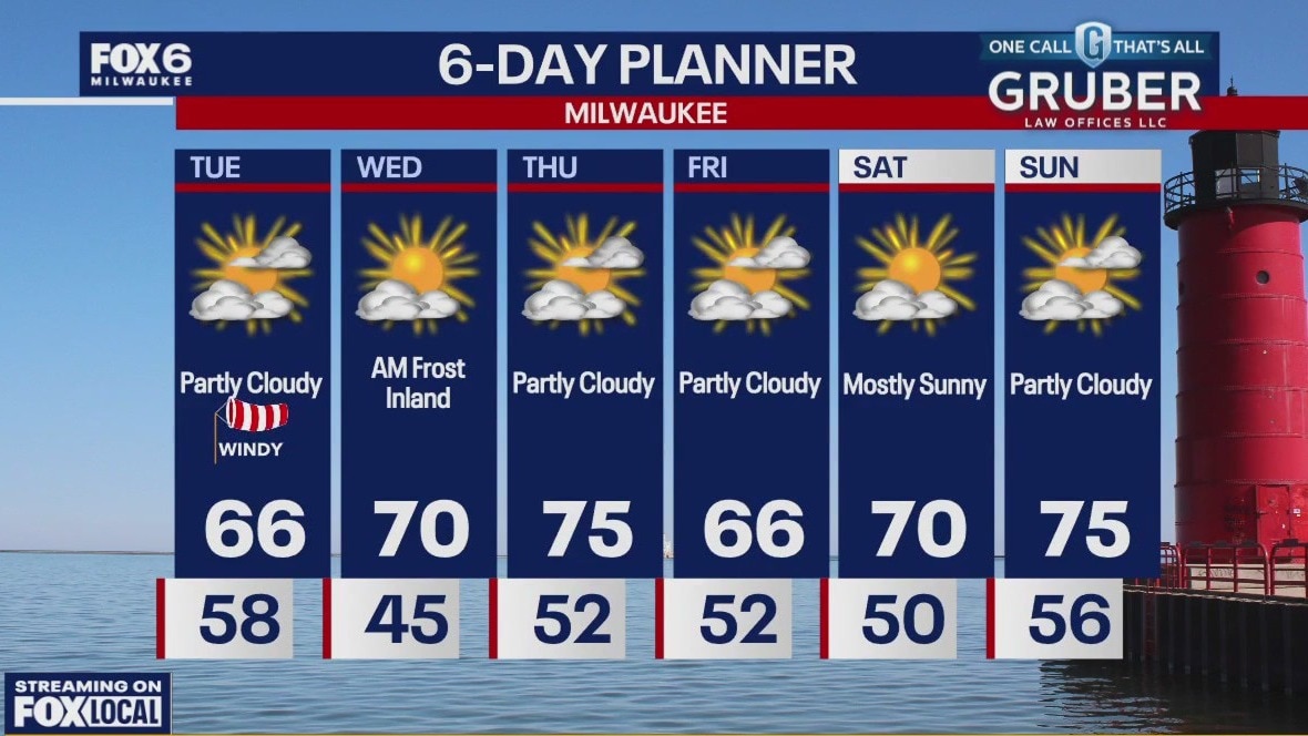
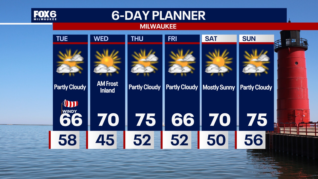
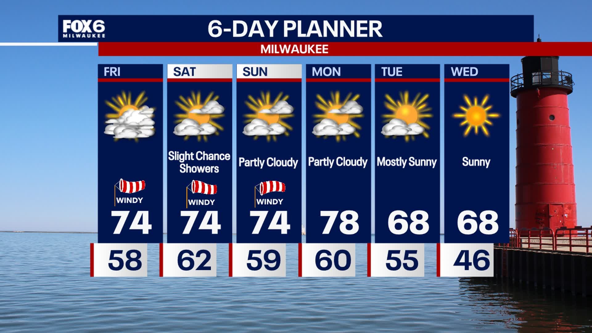
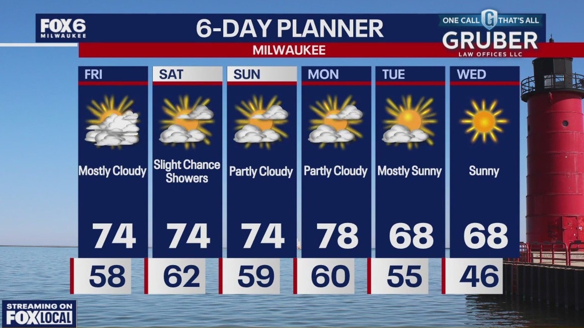
A cold front moves through early Tuesday morning. This will bring cooler air and breezy conditions today. Highs in the mid 60s. Morning temps on Wednesday could be in the 30s for spots inland, 40s elsewhere. Temperatures will be back to 70 by the afternoon. Slight chance for showers Thursday night, otherwise more dry weather expected heading into the weekend. Most of the week will remain dry so extra watering may be needed.
A cold front moves through early Tuesday morning. This will bring cooler air and breezy conditions today. Highs in the mid 60s. Morning temps on Wednesday could be in the 30s for spots inland, 40s elsewhere. Temperatures will be back to 70 by the afternoon. Slight chance for showers Thursday night, otherwise more dry weather expected heading into the weekend. Most of the week will remain dry so extra watering may be needed.
Weather Webcast with Chief Meteorologist Tom Wachs
Sprinkles possible overnight as a cold front moves through. Temperatures will drop into the 50s. The sun returns on Tuesday, but it will be windy and much cooler. Highs in the low-to-mid 60s.
Sprinkles possible overnight as a cold front moves through. Temperatures will drop into the 50s. The sun returns on Tuesday, but it will be windy and much cooler. Highs in the low-to-mid 60s.

Weather Webcast with Chief Meteorologist Tom Wachs
Increasing clouds overnight with sprinkles possible. Temperatures dropping into the 50s. Windy and much cooler on Tuesday with highs in the mid-60s.
Increasing clouds overnight with sprinkles possible. Temperatures dropping into the 50s. Windy and much cooler on Tuesday with highs in the mid-60s.

Weather Webcast with Stephanie Barichello
Warm and even a bit muggy today then a cold front passes overnight, dropping high temperatures into the 60s on Tuesday. There is just a slight chance for sprinkles overnight. Chilly Wednesday morning then we're back in the 70s. Still looking mainly dry through the weekend.
Warm and even a bit muggy today then a cold front passes overnight, dropping high temperatures into the 60s on Tuesday. There is just a slight chance for sprinkles overnight. Chilly Wednesday morning then we're back in the 70s. Still looking mainly dry through the weekend.
Weather webcast with Lisa Michaels
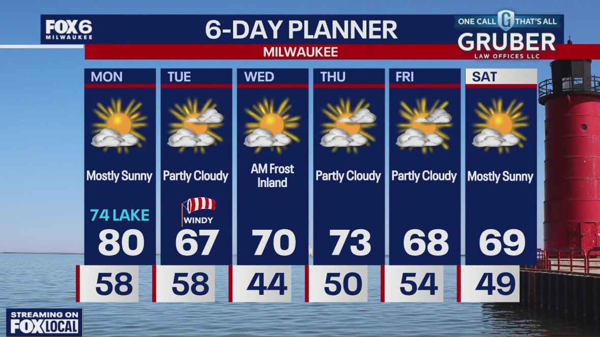
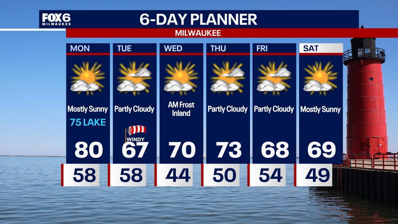
Patchy morning fog. Mostly sunny Monday with highs near 80F in inland and mid 70s near the lake this afternoon. A cold front moves through by Tuesday morning cooling high temps back near average in the upper 60s with breezy winds. Morning temps on Wednesday could be in the 30s for spots inland. Watching for the potential of light frost. More seasonable temps hold through the week with a mostly dry forecast.
Patchy morning fog. Mostly sunny Monday with highs near 80F in inland and mid 70s near the lake this afternoon. A cold front moves through by Tuesday morning cooling high temps back near average in the upper 60s with breezy winds. Morning temps on Wednesday could be in the 30s for spots inland. Watching for the potential of light frost. More seasonable temps hold through the week with a mostly dry forecast.

Weather Webcast with Chief Meteorologist Tom Wachs
Patchy fog overnight with temperatures dropping into the 50s. Mostly sunny and warm for one more day on Monday. Highs between 75 and 80. Windy and cooler on Tuesday.
Patchy fog overnight with temperatures dropping into the 50s. Mostly sunny and warm for one more day on Monday. Highs between 75 and 80. Windy and cooler on Tuesday.
Weather Webcast with Chief Meteorologist Tom Wachs
Mostly clear with patchy fog overnight. Temperatures dropping into the 50s by sunrise. Mostly sunny and warm for one more day on Monday. High near 80 inland, mid-70s near the lake. Cooler on Tuesday with highs in the 60s.
Mostly clear with patchy fog overnight. Temperatures dropping into the 50s by sunrise. Mostly sunny and warm for one more day on Monday. High near 80 inland, mid-70s near the lake. Cooler on Tuesday with highs in the 60s.
Weather webcast with Lisa Michaels
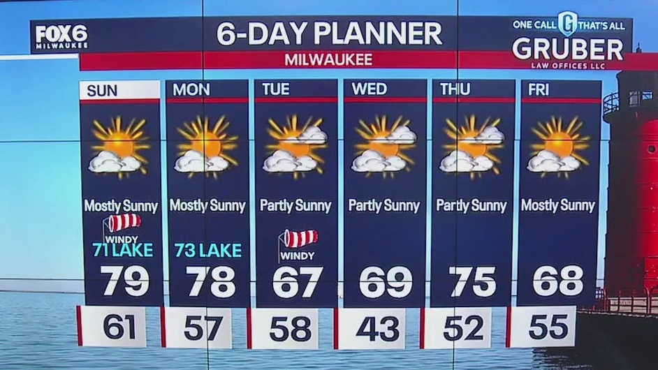
Mostly sunny skies on Sunday with highs in the upper 70s inland to low 70s near the lake. Breezy northeasterly winds today can gust near 25 mph. This will cause dangerous swim conditions in Lake Michigan.
Mostly sunny skies on Sunday with highs in the upper 70s inland to low 70s near the lake. Breezy northeasterly winds today can gust near 25 mph. This will cause dangerous swim conditions in Lake Michigan.

Weather Webcast with Holly Baker
Breezy and dry conditions continue with above normal temperatures.
Breezy and dry conditions continue with above normal temperatures.
Weather webcast with Lisa Michaels
Areas near the border will have more cloud coverage today with a slight chance for a shower. Otherwise, partly cloudy to mostly sunny. Breezy Saturday with northeasterly winds gusting near 25 mph.
Areas near the border will have more cloud coverage today with a slight chance for a shower. Otherwise, partly cloudy to mostly sunny. Breezy Saturday with northeasterly winds gusting near 25 mph.

Weather Webcast with Holly Baker
Skies become mostly cloudy with breezy conditions.
Skies become mostly cloudy with breezy conditions.
Weather Webcast with Stephanie Barichello
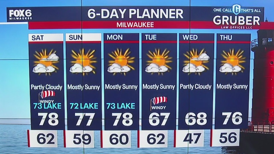
More clouds and windy conditions ahead this afternoon and into the weekend, as Helene pushes northward. Only a slight chance for showers Saturday along the IL state line, most of the rain will stay south. Warming up to end September then cool yet seasonable to start October on Tuesday.
More clouds and windy conditions ahead this afternoon and into the weekend, as Helene pushes northward. Only a slight chance for showers Saturday along the IL state line, most of the rain will stay south. Warming up to end September then cool yet seasonable to start October on Tuesday.
Weather webcast with Rob Haswell
As what remains of tropical system Helene moves closer today, our wind will ramp up with gusts near 30mph at times. With that strong NE wind staying steady through today into tomorrow we can expect rough conditions on Lake Michigan. There is a Beach Hazards Statement in effect. We should stay dry today but there is a slight chance for showers on Saturday into early Sunday morning with the most likely areas being the far southeast counties. A brief cool down next week to usher in October but otherwise well above average temperatures persist.
As what remains of tropical system Helene moves closer today, our wind will ramp up with gusts near 30mph at times. With that strong NE wind staying steady through today into tomorrow we can expect rough conditions on Lake Michigan. There is a Beach Hazards Statement in effect. We should stay dry today but there is a slight chance for showers on Saturday into early Sunday morning with the most likely areas being the far southeast counties. A brief cool down next week to usher in October but otherwise well above average temperatures persist.