

Rain, snow expected; Thursday morning commute could be impacted
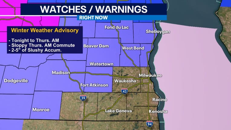
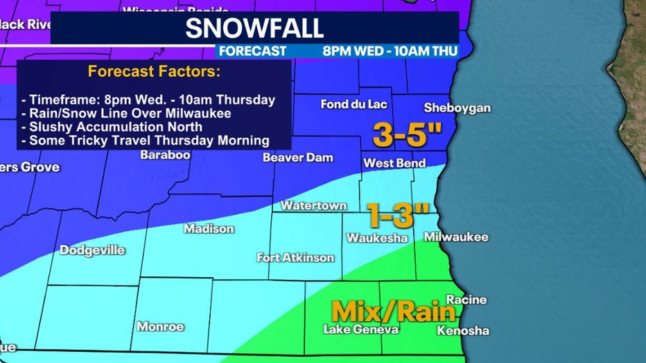
MILWAUKEE - Rain, snow, and a wintry mix will arrive later Wednesday evening across southeastern Wisconsin, starting after 8 p.m. across southern counties and closer to 10 p.m. farther north. A Winter Weather Advisory is in effect for parts of SE WI through midday Thursday.
Parts of Waukesha and Milwaukee County southward will primarily see rain and wintry mix, while areas northward see a heavy, wet snow. Highest snowfall totals are expected across Fond du Lac and Sheboygan counties.
The wintry mess will continue through Thursday morning, creating soggy and slushy conditions. Although the main wave of rain and snow will taper off mid-morning Thursday, a few more light rain and snow showers will be possible throughout the afternoon. No additional snowfall accumulation expected.
SIGN UP TODAY: Get daily headlines, breaking news emails from FOX6 News
Stay tuned for updates as any shift in track, even by 10 miles could change the rain/snow forecast – especially for Milwaukee.
Meanwhile, FOX6Now.com offers a variety of extremely useful weather tools to help you navigate the stormy season. They include the following:
FOX6 Storm Center app
FOX6 News app
FOX Weather app
MAPS AND RADAR
We have a host of maps and radars on the FOX6 Weather page that are updating regularly — to provide you the most accurate assessment of the weather. From a county-by-county view to the Midwest regional radar and a national view — it’s all there.
SCHOOL AND BUSINESS CLOSINGS
When the weather gets a little dicey, schools and businesses may shut down. Monitor the latest list of closings, cancellations, and delays reported in southeast Wisconsin.

FOX6 WEATHER IN SOCIAL MEDIA
- CLICK HERE to "Like" the FOX6 Weather Team on Facebook
- CLICK HERE to "Like" Rob Haswell on Facebook
- CLICK HERE to "Like" Tom Wachs on Facebook
- CLICK HERE to "Like" Stephanie Barichello on Facebook
- CLICK HERE to "Like" Eric Manges on Facebook
- CLICK HERE to "Like" Lisa Michaels on Facebook
- CLICK HERE to "Follow" the FOX6 Weather Team on Twitter
- CLICK HERE to "Follow" Rob Haswell on Twitter
- CLICK HERE to "Follow" Tom Wachs on Twitter
- CLICK HERE to "Follow" Stephanie Barichello on Twitter
- CLICK HERE to "Follow" Eric Manges on Twitter
- CLICK HERE to "Follow" Lisa Michaels on Twitter