

Rainfall reports from Feb. 27; precipitation records broken
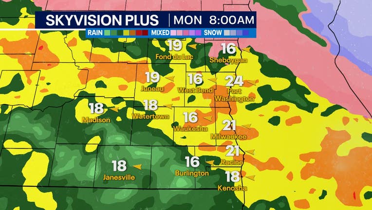
Monday, Feb. 27 started out with heavy rain, embedded thunderstorms, and freezing rain in some northern areas near Fond du Lac and Sheboygan.
Heavy rainfall and mild temperatures helped melt snow which further equated to additional water on the ground. This caused a concern for flooding across southeast Wisconsin. Rivers, creeks, streams, and additional areas may have experienced low-lying flooding close to noon yesterday when flood watches and warnings were in effect. Rainfall reports came in over 2" for many locations.
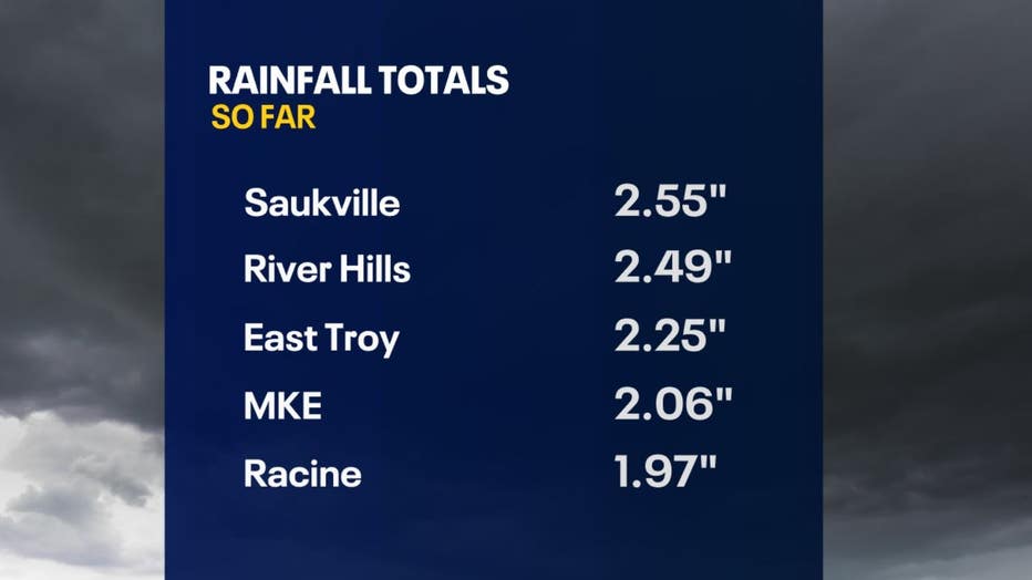
A few additional locations with reports are: Wauwatosa with 2.23", Hales Corners with 2.23", and Adell with 0.10" of ice from freezing rain.
Not only did we see heavy rain, but precipitation records were broken yesterday! Mitchell International Airport, where the official Milwaukee weather surface observation is located, recorded a total of 2.06" of rainfall. This is 1.99" above normal for the day and breaks the old record for total rainfall on Feb. 27 which was recorded at 1.17" back in 1948.
Yesterday, we also broke the record for highest 1-day rainfall total for any day in February. The previous record was 1.81" on Feb. 21, 1913.
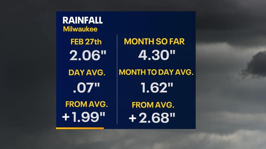
Overall, February has been a wet month with snow and rain giving a total precipitation amount so far at 4.30" through Feb. 27, 2023. Milwaukee has experienced rain 2.68" above the average which should usually have 1.62".
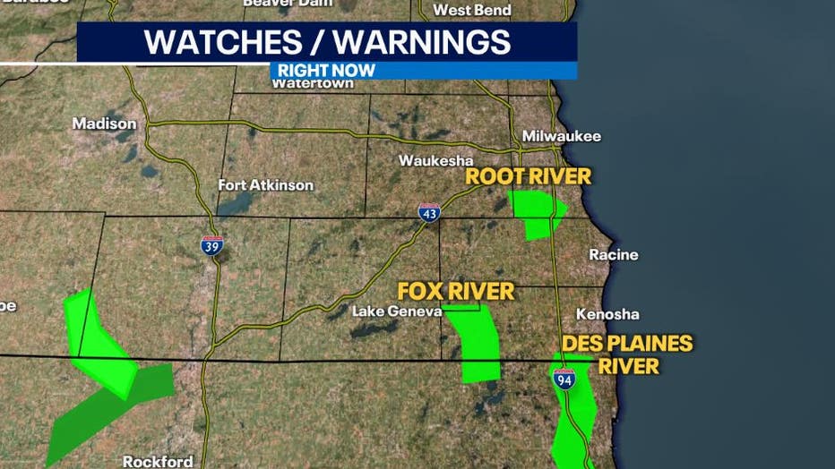
Even though the system is moving off to the east coast, southern Wisconsin is still experiencing impacts from the high amounts of rain and melting snow.
Flood warnings are in effect for:
- Southern Milwaukee and northern Racine counties where the Root River is located. As of 8 a.m. Feb. 28, it's at minor flood stage over 11' and is expected to crest at 12.7' Thursday morning.
- Southwest Racine and western Kenosha counties where the Fox River is located. As of 8 a.m. Feb. 28, it's at minor flood stage just over 9.5' and is receding already.
- Southeastern Kenosha county where the Des Plaines River is located. As of 8 a.m. Feb. 28, it's at minor flood stage over 7' and is expected to crest at 7.5' Wednesday morning.
If you are near these locations and see elevated levels of water and/or flooding over roads, please do not attempt to drive through them.
FOX6 Weather Extras
Meanwhile, FOX6Now.com offers a variety of extremely useful weather tools to help you navigate the stormy season. They include the following:
FOX6 Storm Center app

FOX6 News app
FOX Weather app
MAPS AND RADAR
We have a host of maps and radars on the FOX6 Weather page that are updating regularly — to provide you the most accurate assessment of the weather. From a county-by-county view to the Midwest regional radar and a national view — it’s all there.
SCHOOL AND BUSINESS CLOSINGS
When the weather gets a little dicey, schools and businesses may shut down. Monitor the latest list of closings, cancellations, and delays reported in southeast Wisconsin.

FOX6 WEATHER IN SOCIAL MEDIA
- CLICK HERE to "Like" the FOX6 Weather Team on Facebook
- CLICK HERE to "Like" Rob Haswell on Facebook
- CLICK HERE to "Like" Tom Wachs on Facebook
- CLICK HERE to "Like" Stephanie Barichello on Facebook
- CLICK HERE to "Like" Eric Manges on Facebook
- CLICK HERE to "Like" Lisa Michaels on Facebook
- CLICK HERE to "Follow" the FOX6 Weather Team on Twitter
- CLICK HERE to "Follow" Rob Haswell on Twitter
- CLICK HERE to "Follow" Tom Wachs on Twitter
- CLICK HERE to "Follow" Stephanie Barichello on Twitter
- CLICK HERE to "Follow" Eric Manges on Twitter
- CLICK HERE to "Follow" Lisa Michaels on Twitter