


Kenosha damage following SE Wisconsin severe storms
A wild weather day across Wisconsin and beyond, with strong storms moving through the southern part of the state and prompting tornado warnings on Thursday, April 2. Sam Kraemer surveys Kenosha after reports of damage.
A wild weather day across Wisconsin and beyond, with strong storms moving through the southern part of the state and prompting tornado warnings on Thursday, April 2. Sam Kraemer surveys Kenosha after reports of damage.
Weather Webcast with Holly Baker
We are tracking severe weather through the evening.
We are tracking severe weather through the evening.

Southeast Wisconsin weather: watches, warnings expire
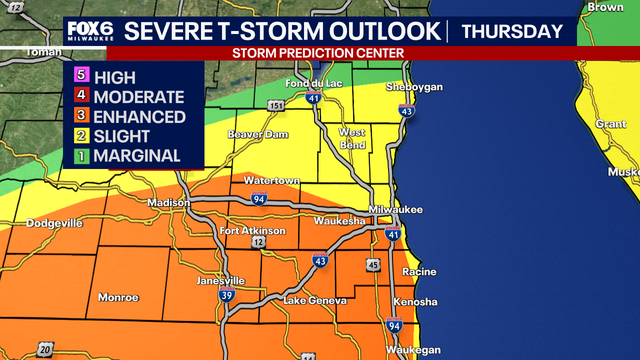
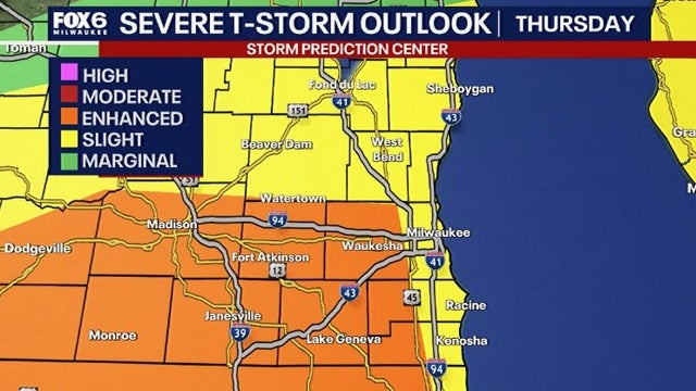
The Storm Prediction Center has issued southern Wisconsin under an enhanced risk for severe storms Thursday afternoon and evening, April 2.
The Storm Prediction Center has issued southern Wisconsin under an enhanced risk for severe storms Thursday afternoon and evening, April 2.
Severe weather risk Thursday: 2 scenarios possible
There's a significant risk for severe weather in southeastern Wisconsin on Thursday, April 2, but the severity will depend on a few factors. FOX6 Meteorologist Lisa Michaels explains.
There's a significant risk for severe weather in southeastern Wisconsin on Thursday, April 2, but the severity will depend on a few factors. FOX6 Meteorologist Lisa Michaels explains.
Weather webcast with meteorologist Lisa Michaels
We start with freezing rain and quickly pivot into a high-shear severe weather environment by late afternoon and evening. Even with limited instability, the dynamics are strong enough to support damaging winds and a quick spin-up tornado risk as storms organize into a line.
We start with freezing rain and quickly pivot into a high-shear severe weather environment by late afternoon and evening. Even with limited instability, the dynamics are strong enough to support damaging winds and a quick spin-up tornado risk as storms organize into a line.
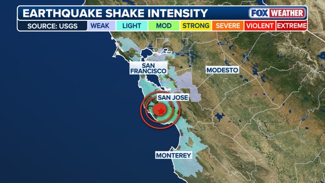

Powerful magnitude 4.6 earthquake rattles cities across central California
Residents across parts of central California were shaken by a 4.6 earthquake in the early Thursday morning hours.
Residents across parts of central California were shaken by a 4.6 earthquake in the early Thursday morning hours.
Weather webcast with Rob Haswell
Thursday is a classic early April split setup across southern Wisconsin. We start with freezing rain and quickly pivot into a high-shear severe weather environment by late afternoon and evening.
Thursday is a classic early April split setup across southern Wisconsin. We start with freezing rain and quickly pivot into a high-shear severe weather environment by late afternoon and evening.


Milwaukee Weather: Wintry mix early, severe storms late day
Thursday is a classic early April split setup across southern Wisconsin. We start with freezing rain and quickly pivot into a high-shear severe weather environment by late afternoon and evening.
Thursday is a classic early April split setup across southern Wisconsin. We start with freezing rain and quickly pivot into a high-shear severe weather environment by late afternoon and evening.
Weather Webcast with Holly Baker
We are tracking a chance for storms on the way tomorrow.
We are tracking a chance for storms on the way tomorrow.

Weather Webcast with Stephanie Barichello
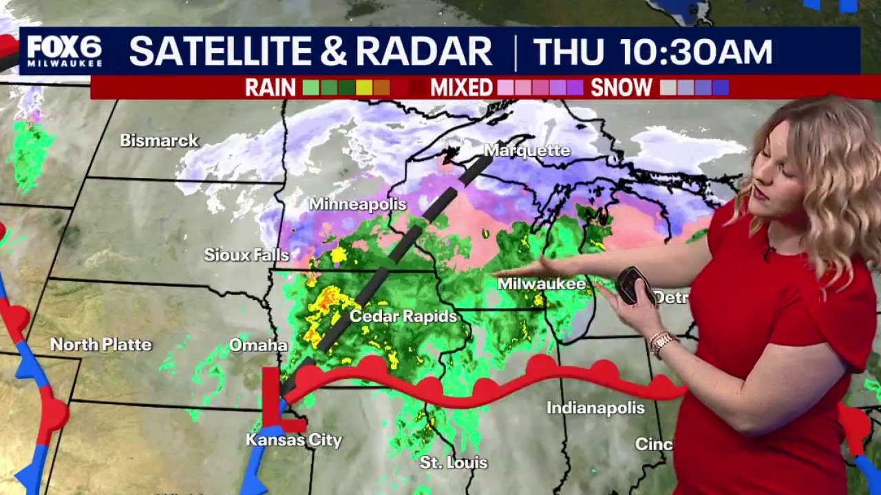
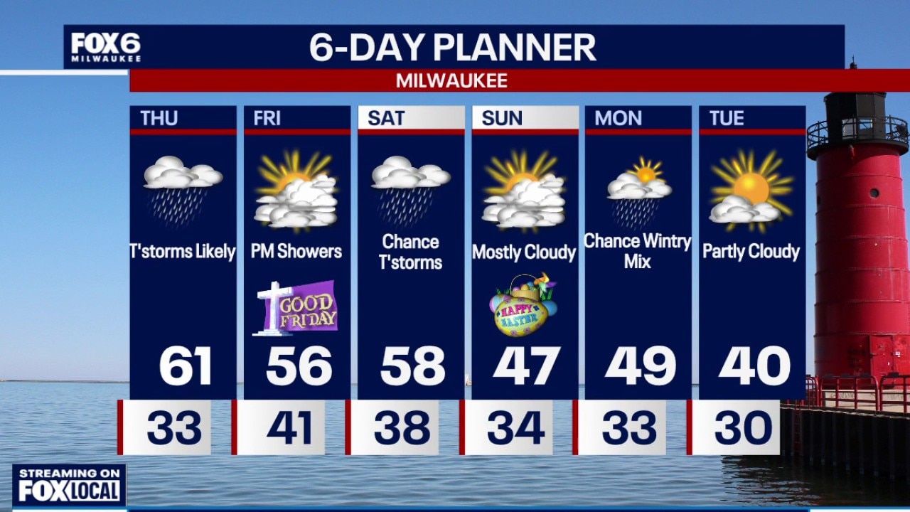
Rain moves in after midnight tonight with freezing rain across northern communities through mid morning Thursday. There is a Winter Weather Advisory for those spots that could pick up a glaze to .2" of ice. Steady rain continues the rest of the day with thunderstorms during the afternoon and evening. There is a chance for severe weather, including tornadoes, so stay weather aware.
Rain moves in after midnight tonight with freezing rain across northern communities through mid morning Thursday. There is a Winter Weather Advisory for those spots that could pick up a glaze to .2" of ice. Steady rain continues the rest of the day with thunderstorms during the afternoon and evening. There is a chance for severe weather, including tornadoes, so stay weather aware.

Wisconsin wild spring weather; icing to severe storms Thursday
Freezing rain could cause an icy morning commute Thursday, then heavy rain continues throughout the day with a chance of severe weather by early evening.
Freezing rain could cause an icy morning commute Thursday, then heavy rain continues throughout the day with a chance of severe weather by early evening.
Milwaukee Weather: Icy Thursday morning, severe threat by evening
Freezing rain is possible overnight and Thursday morning north of I-94, where a winter weather advisory is in effect until 9am. Showers and thunderstorms expected Thursday, possibly severe with a tornado threat during the evening.
Freezing rain is possible overnight and Thursday morning north of I-94, where a winter weather advisory is in effect until 9am. Showers and thunderstorms expected Thursday, possibly severe with a tornado threat during the evening.
Weather webcast with Stephanie Barichello
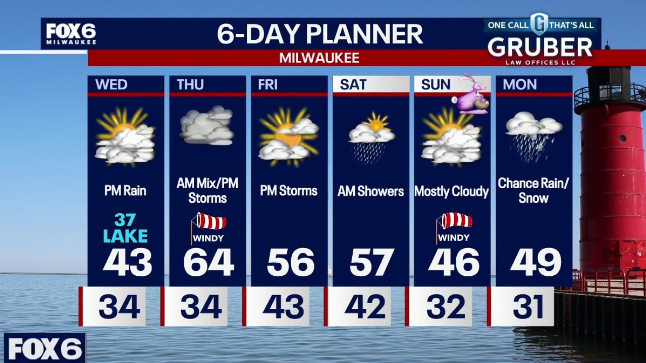
Cooler Wednesday with temperatures in the upper 30s near the lake to low/mid 40s inland. Mostly cloudy during the day and dry. Rain returns Wednesday night with a chance of freezing rain north of I-94 heading into early Thursday.
Cooler Wednesday with temperatures in the upper 30s near the lake to low/mid 40s inland. Mostly cloudy during the day and dry. Rain returns Wednesday night with a chance of freezing rain north of I-94 heading into early Thursday.
Weather webcast with Lisa Michaels
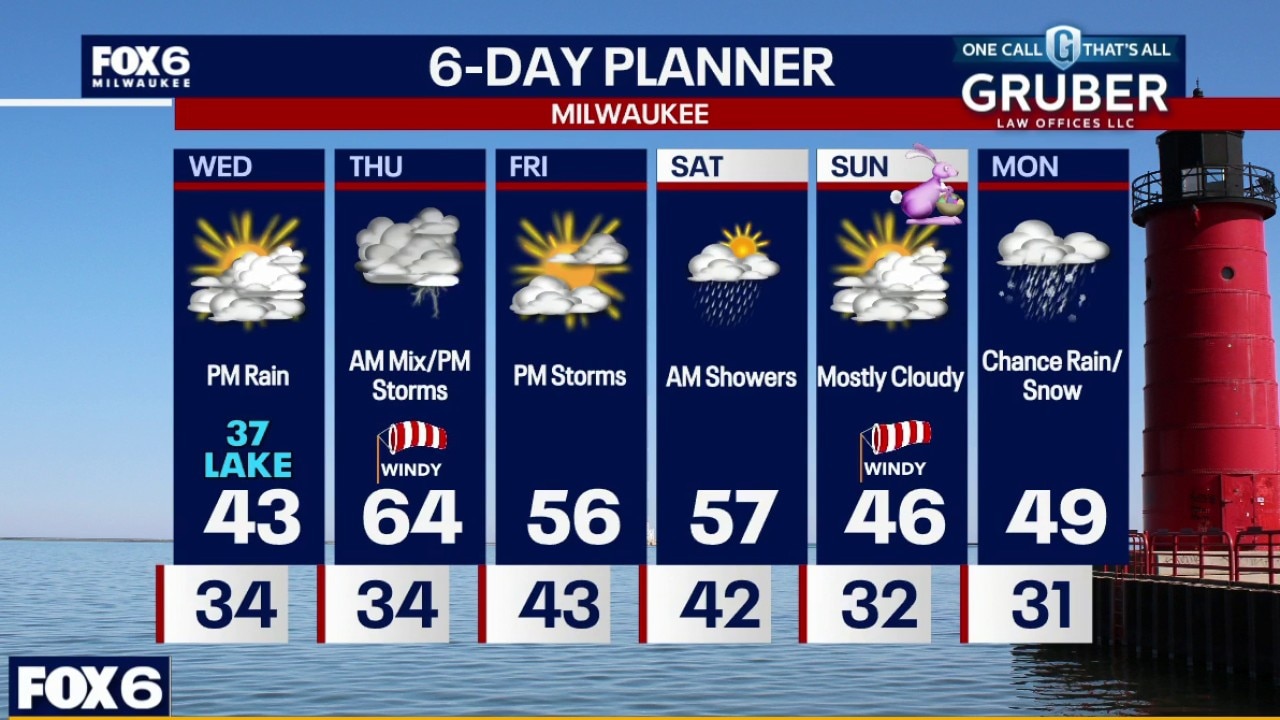
Cooler Wednesday with temperatures in the upper 30s near the lake to low/mid 40s inland. Mostly cloudy during the day and dry. Rain returns Wednesday night with a chance of freezing rain north of I-94 heading into early Thursday.
Cooler Wednesday with temperatures in the upper 30s near the lake to low/mid 40s inland. Mostly cloudy during the day and dry. Rain returns Wednesday night with a chance of freezing rain north of I-94 heading into early Thursday.
Weather Webcast with Holly Baker
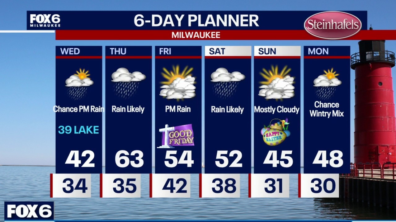
More rain is on the way for the upcoming days with temperatures on a rollercoaster ride.
More rain is on the way for the upcoming days with temperatures on a rollercoaster ride.
Milwaukee Weather: Drying tonight, next round of rain Wednesday PM
Drying out this evening with temperatures dropping into the low 30s overnight. Rain showers return by Wednesday evening, with a chance of freezing rain overnight north of Highway 33.
Drying out this evening with temperatures dropping into the low 30s overnight. Rain showers return by Wednesday evening, with a chance of freezing rain overnight north of Highway 33.

Weather webcast with Stephanie Barichello
We’re locked into a very active spring pattern, with multiple waves of rain and thunderstorms rolling through southern Wisconsin and plenty of moving parts in the forecast.
We’re locked into a very active spring pattern, with multiple waves of rain and thunderstorms rolling through southern Wisconsin and plenty of moving parts in the forecast.

Weather webcast with Rob Haswell
We’re locked into a very active spring pattern, with multiple waves of rain and thunderstorms rolling through southern Wisconsin and plenty of moving parts in the forecast.
We’re locked into a very active spring pattern, with multiple waves of rain and thunderstorms rolling through southern Wisconsin and plenty of moving parts in the forecast.
Milwaukee Weather: Possible severe storms tonight and Tuesday
Thunderstorms are possible overnight in parts of SE WI, especially near the IL state line. Storms will be capable of producing large hail up to ping pong size.
Thunderstorms are possible overnight in parts of SE WI, especially near the IL state line. Storms will be capable of producing large hail up to ping pong size.
Weather Webcast with Stephanie Barichello
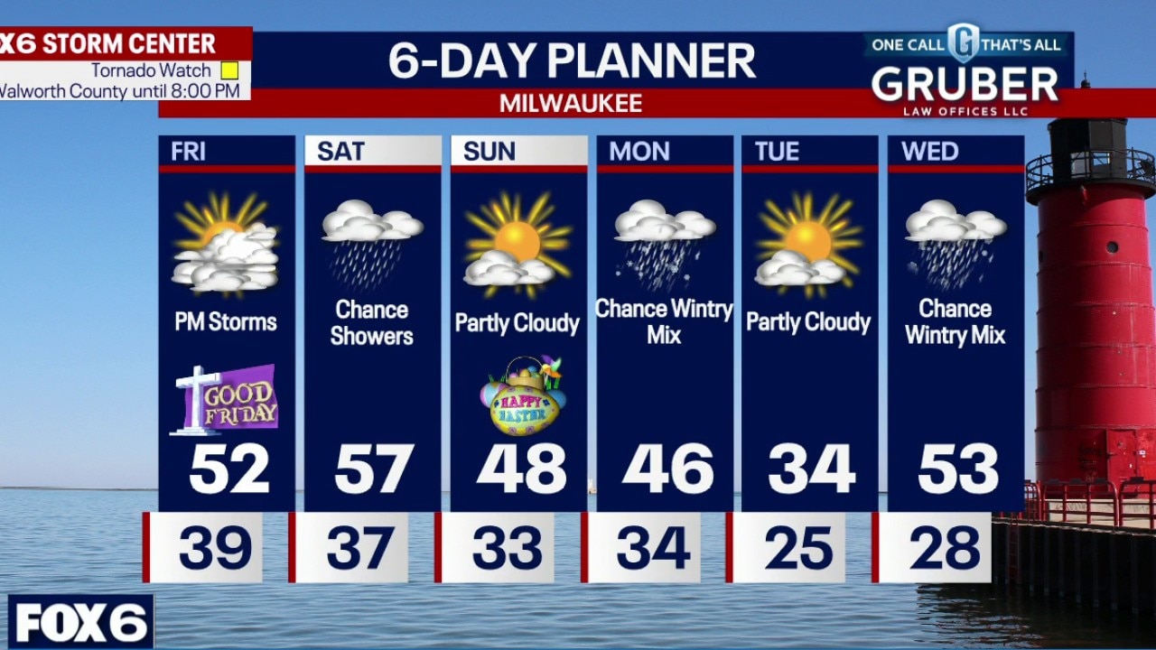
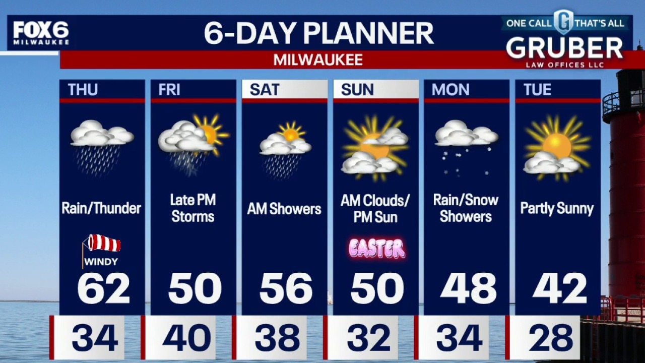
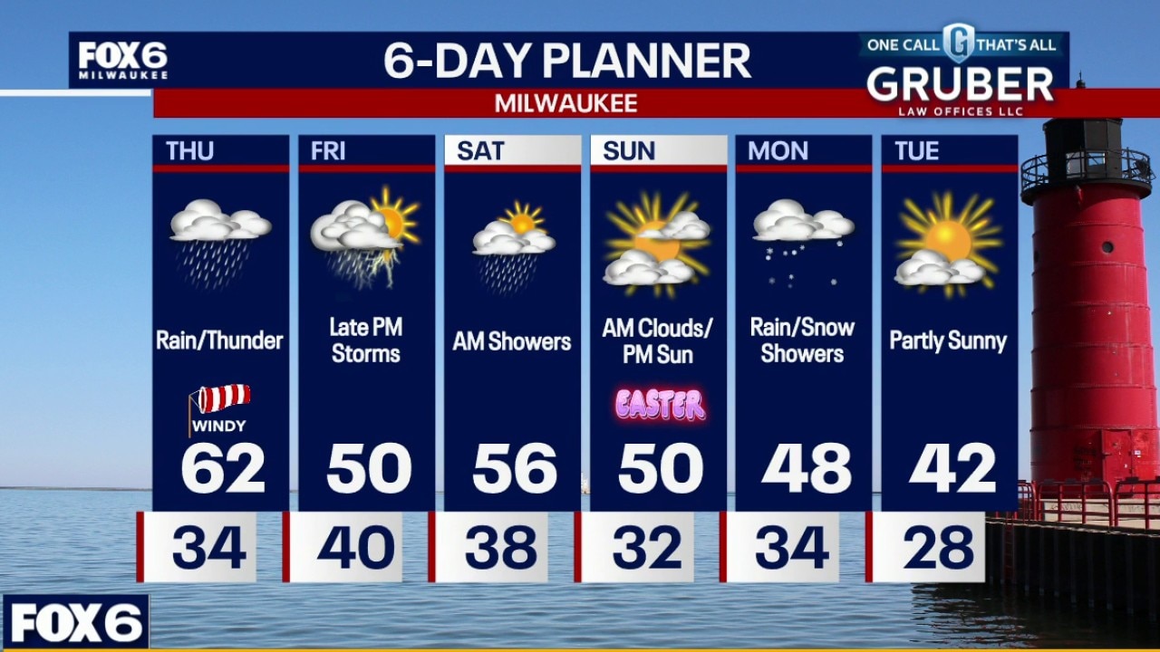
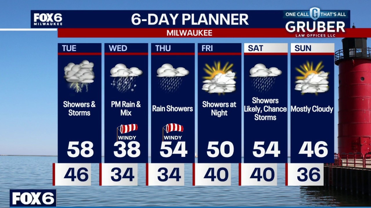
A chance for thunderstorms after 10pm, mainly across southern counties. A strong to severe storm with large hail cannot be ruled out. Another round of storms Tuesday, mainly during the afternoon and evening, with hail and gusty wind possible. Another storm expected Wednesday into Thursday as wintry mix and rain. Saturday will also be soggy before a dry but cool Easter Sunday.
A chance for thunderstorms after 10pm, mainly across southern counties. A strong to severe storm with large hail cannot be ruled out. Another round of storms Tuesday, mainly during the afternoon and evening, with hail and gusty wind possible. Another storm expected Wednesday into Thursday as wintry mix and rain. Saturday will also be soggy before a dry but cool Easter Sunday.