


Weather Webcast with Meteorologist Lisa Michaels
Winter storm warning and winter weather advisory across southeast Wisconsin until 4PM. Wet and heavy snow will continue through Saturday. 5-8" is possible in many locations. Most accumulation on elevated and grassy surfaces.
Winter storm warning and winter weather advisory across southeast Wisconsin until 4PM. Wet and heavy snow will continue through Saturday. 5-8" is possible in many locations. Most accumulation on elevated and grassy surfaces.


Snowfall totals: Wisconsin winter storm March 25, 2023
The National Weather Service is collecting data from the heavy snowfall that impacted southeast Wisconsin on Saturday, March 25, 2023.
The National Weather Service is collecting data from the heavy snowfall that impacted southeast Wisconsin on Saturday, March 25, 2023.

Weather Webcast with Meteorologist Eric Manges
Impactful snow tonight of widespread 4-8" possible with higher totals SE. Winter Storm Warning until 1pm Saturday.
Impactful snow tonight of widespread 4-8" possible with higher totals SE. Winter Storm Warning until 1pm Saturday.
Weather Webcast With Lisa Michaels
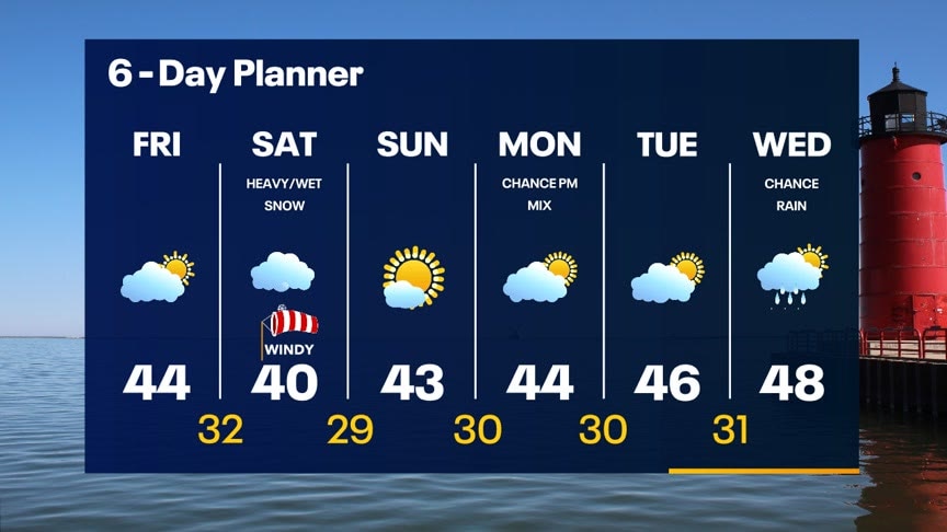
A low pressure will move northeast across Missouri and Illinois today into Saturday. This will bring the chance for heavy/wet snow Saturday morning into the early afternoon. Gusty winds up to 35mph through Saturday will reduce visibility when snow falls. Winter weather advisory begins 4AM-1PM Saturday. 4-8 inches possible for some areas. Sunshine and the low to mid 40s back by Sunday.
A low pressure will move northeast across Missouri and Illinois today into Saturday. This will bring the chance for heavy/wet snow Saturday morning into the early afternoon. Gusty winds up to 35mph through Saturday will reduce visibility when snow falls. Winter weather advisory begins 4AM-1PM Saturday. 4-8 inches possible for some areas. Sunshine and the low to mid 40s back by Sunday.
Weather webcast with Rob Haswell
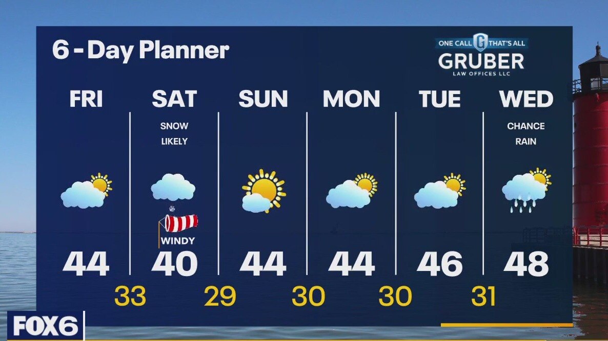
A low developing in Texas today will move across Illinois and into Michigan tonight and tomorrow morning. Ahead of that low today we can expect increasingly cloudy conditions with highs in the low to mid 40s. As the low gets closer overnight, we will see a wintry mix or rain changing to a heavy snow. Steady moderate to heavy snow is likely through early afternoon on Saturday. A Winter Weather Advisory begins at 4am Saturday. 3-6 inches of snow are possible in some areas.
A low developing in Texas today will move across Illinois and into Michigan tonight and tomorrow morning. Ahead of that low today we can expect increasingly cloudy conditions with highs in the low to mid 40s. As the low gets closer overnight, we will see a wintry mix or rain changing to a heavy snow. Steady moderate to heavy snow is likely through early afternoon on Saturday. A Winter Weather Advisory begins at 4am Saturday. 3-6 inches of snow are possible in some areas.

Northern lights in southeast Wisconsin Thursday night
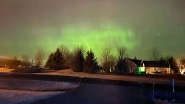
FOX6 viewers shared photos of the northern lights, visible in southeast Wisconsin Thursday night.
FOX6 viewers shared photos of the northern lights, visible in southeast Wisconsin Thursday night.

Northern lights seen in New Berlin Thursday night
A FOX6 viewer shared a shot of the northern lights as seen in New Berlin Thursday night. With clear skies, the National Weather Service Milwaukee said they could be visible along the horizon.
A FOX6 viewer shared a shot of the northern lights as seen in New Berlin Thursday night. With clear skies, the National Weather Service Milwaukee said they could be visible along the horizon.
Weather Webcast with Tom Wachs
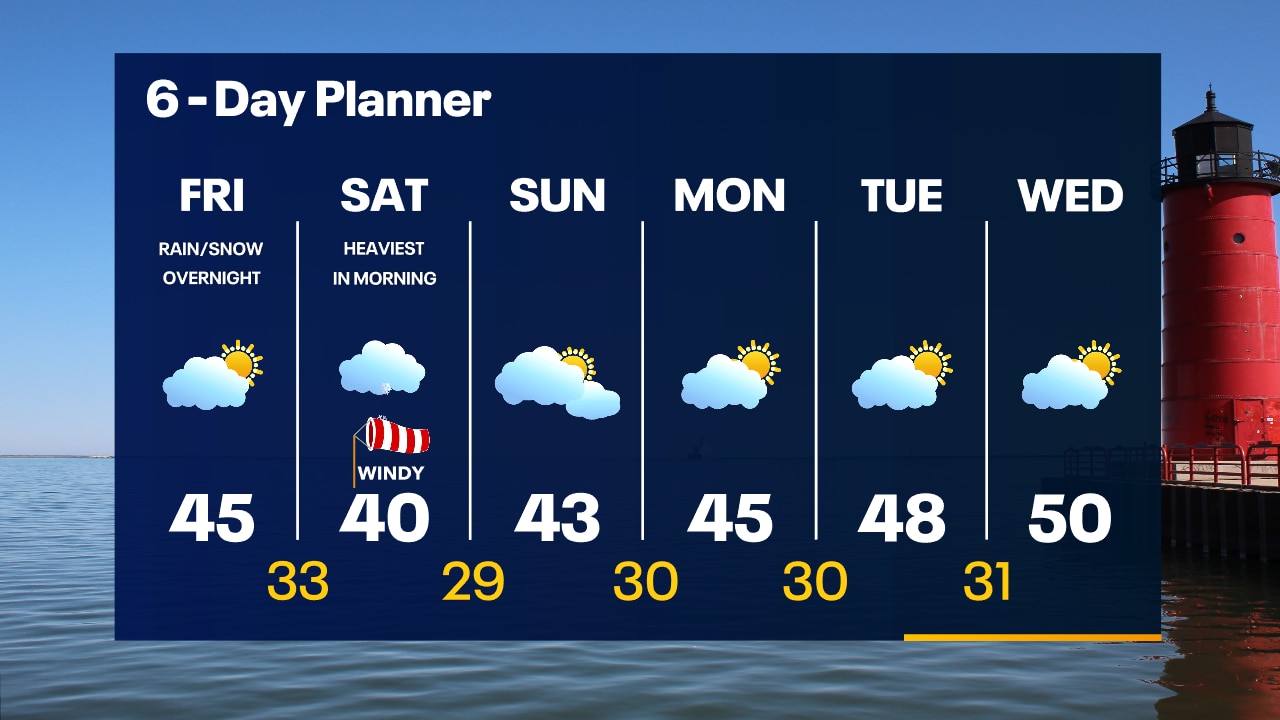
Mostly clear overnight with temperatures dropping into the 20s. Partly sunny on Friday with highs in the mid-40s. Snow moves in early Saturday morning with several inches likely.
Mostly clear overnight with temperatures dropping into the 20s. Partly sunny on Friday with highs in the mid-40s. Snow moves in early Saturday morning with several inches likely.
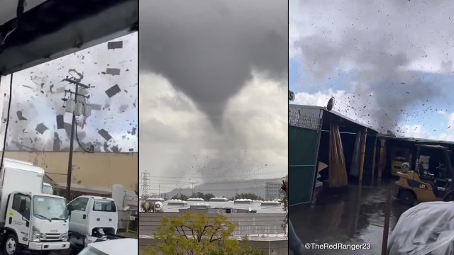

Tornado rips through Montebello; strongest tornado to hit Los Angeles-area in 40 years
The tornado was the strongest to hit the LA Metro area in 40 years.
The tornado was the strongest to hit the LA Metro area in 40 years.

Weather Webcast with Tom Wachs
Quiet tonight and again on Friday. Accumulating snow moves in overnight Friday night into Saturday. The heaviest will be Saturday morning.
Quiet tonight and again on Friday. Accumulating snow moves in overnight Friday night into Saturday. The heaviest will be Saturday morning.
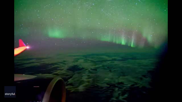

Watch: Lucky passenger captures stunning time-lapse video of northern lights from plane window
A passenger on a flight from Alaska to Washington was able to capture a stunning time-lapse video of the northern lights while the airplane zoomed across the night sky.
A passenger on a flight from Alaska to Washington was able to capture a stunning time-lapse video of the northern lights while the airplane zoomed across the night sky.
Weather Webcast with Meteorologist Stephanie Barichello
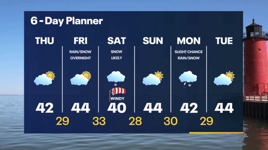
Decreasing clouds this afternoon then more sunshine on Friday. Snow is back in the forecast Saturday, and it looks likely that it'll accumulate. Better by Sunday then another round of wintry mix Monday.
Decreasing clouds this afternoon then more sunshine on Friday. Snow is back in the forecast Saturday, and it looks likely that it'll accumulate. Better by Sunday then another round of wintry mix Monday.

Weather webcast with Rob Haswell
A brief area of rain/snow and wintry mix passes through this morning. A light accumulation is possible for areas north and west of the city. This afternoon some sun will break out as we calm down. Highs today will be in the low 40s. Most of our day on Friday will be partly sunny and calm but overnight Friday into Saturday a stronger low arrives. Accumulating snow is expected Friday night and Saturday morning with a few inches possible in some areas. Sunday we will start melting that snow with some sun and mid 40s.
A brief area of rain/snow and wintry mix passes through this morning. A light accumulation is possible for areas north and west of the city. This afternoon some sun will break out as we calm down. Highs today will be in the low 40s. Most of our day on Friday will be partly sunny and calm but overnight Friday into Saturday a stronger low arrives. Accumulating snow is expected Friday night and Saturday morning with a few inches possible in some areas. Sunday we will start melting that snow with some sun and mid 40s.

Weather Webcast with Tom Wachs
Rain/snow moving through overnight. It will taper off by 9am. Heaviest between 3-6am. Slushy accumulation possible in a few areas. Check roads before heading out in the morning.
Rain/snow moving through overnight. It will taper off by 9am. Heaviest between 3-6am. Slushy accumulation possible in a few areas. Check roads before heading out in the morning.
Weather Webcast with Tom Wachs
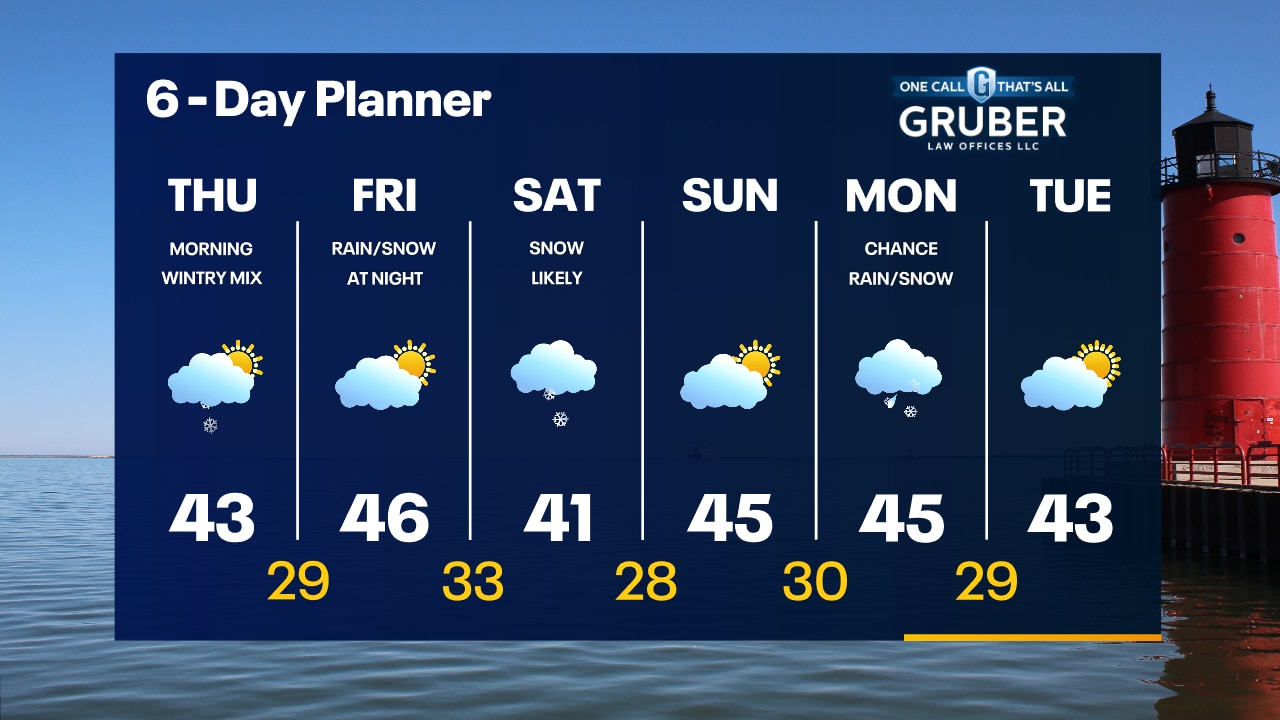
Rain/snow showers move in overnight into Thursday morning. A few slushy spots are possible. The precipitation will end by midday. Dry Thursday afternoon with highs in the 40s.
Rain/snow showers move in overnight into Thursday morning. A few slushy spots are possible. The precipitation will end by midday. Dry Thursday afternoon with highs in the 40s.
Weather Webcast with Meteorologist Stephanie Barichello
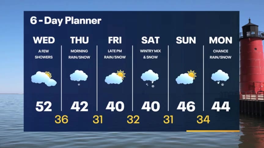
Cloudy but still mild today, then rain and some snow moves through tonight and tomorrow morning. Another round of wintry mix and snow possible Saturday, potentially accumulating. Expect temperatures to stay cooler in the 40s.
Cloudy but still mild today, then rain and some snow moves through tonight and tomorrow morning. Another round of wintry mix and snow possible Saturday, potentially accumulating. Expect temperatures to stay cooler in the 40s.


America's first-ever tornado forecast issued 75 years ago at Oklahoma's Tinker Air Force Base
An unusual pair of tornadoes that struck an Oklahoma Air Force base in March 1948 paved the way for severe weather forecasting as we know it today.
An unusual pair of tornadoes that struck an Oklahoma Air Force base in March 1948 paved the way for severe weather forecasting as we know it today.
Weather webcast with Rob Haswell
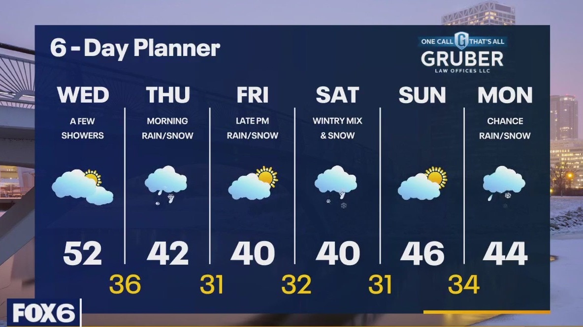
With a warm front to our north and an approaching cold front, we warm into the low 50s today with a chance for a few showers. Showers are possible again tonight but as the cold front passes and colder air arrives, there is a chance for a wintry mix or light snow on Thursday morning. We can expect a break from the precipitation later Thursday into most of the day Friday but by Friday night another system arrives with rain and snow likely and another chance for a wintry mix. We stay active on Saturday but should calm and clear for Sunday.
With a warm front to our north and an approaching cold front, we warm into the low 50s today with a chance for a few showers. Showers are possible again tonight but as the cold front passes and colder air arrives, there is a chance for a wintry mix or light snow on Thursday morning. We can expect a break from the precipitation later Thursday into most of the day Friday but by Friday night another system arrives with rain and snow likely and another chance for a wintry mix. We stay active on Saturday but should calm and clear for Sunday.
Weather Webcast with Tom Wachs
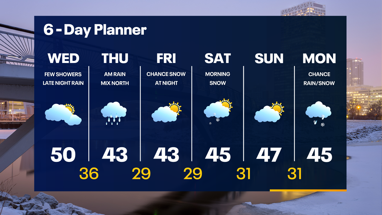
A few spotty light rain showers possible overnight and into the day Wednesday. Morning temperatures in the 30s before warming to around 50 by afternoon. A steady rain is likely overnight Wednesday night.
A few spotty light rain showers possible overnight and into the day Wednesday. Morning temperatures in the 30s before warming to around 50 by afternoon. A steady rain is likely overnight Wednesday night.
Weather Webcast with Tom Wachs
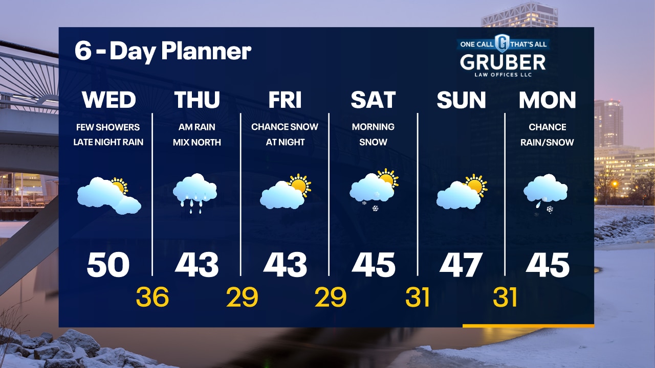
Increasing clouds tonight with temperatures dropping into the 30s overnight. Spotty light rain showers overnight into Wednesday with highs around 50. Steady rain moves in late Wednesday night.
Increasing clouds tonight with temperatures dropping into the 30s overnight. Spotty light rain showers overnight into Wednesday with highs around 50. Steady rain moves in late Wednesday night.