


Tropical Storm Debby: Person killed in likely tornado in North Carolina
Rescue teams found a body in a home destroyed by a tornado in North Carolina that was produced by Tropical Storm Debby.
Rescue teams found a body in a home destroyed by a tornado in North Carolina that was produced by Tropical Storm Debby.
Weather Webcast with Chief Meteorologist Tom Wachs
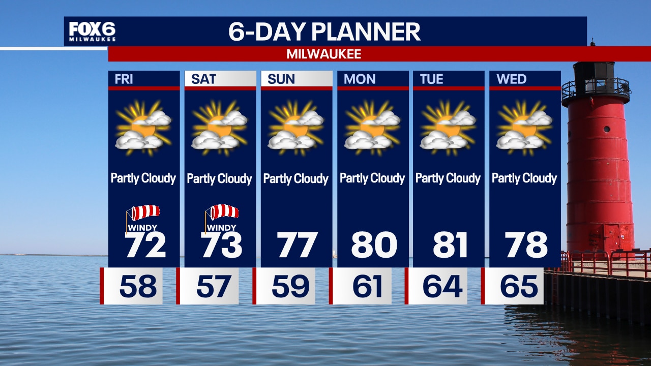
Partly cloudy and breezy tonight with temperatures dropping into the 60s this evening. Humidity levels will drop overnight allowing temperatures to fall into the 50s. Partly sunny, windy and cooler on Friday with highs in the low 70s.
Partly cloudy and breezy tonight with temperatures dropping into the 60s this evening. Humidity levels will drop overnight allowing temperatures to fall into the 50s. Partly sunny, windy and cooler on Friday with highs in the low 70s.

How waterspouts form
FOX6's Meteorologist Rob Haswell explains how waterspouts are formed.
FOX6's Meteorologist Rob Haswell explains how waterspouts are formed.


Mapped: Who’s seen the greatest rainfall from Debby
At least five deaths were attributed to Hurricane Debby as the cyclone moved through the Southeast. Lake City, Florida saw the most rainfall in the Sunshine state with nearly 20" of precipitation.
At least five deaths were attributed to Hurricane Debby as the cyclone moved through the Southeast. Lake City, Florida saw the most rainfall in the Sunshine state with nearly 20" of precipitation.
Weather webcast with Rob Haswell
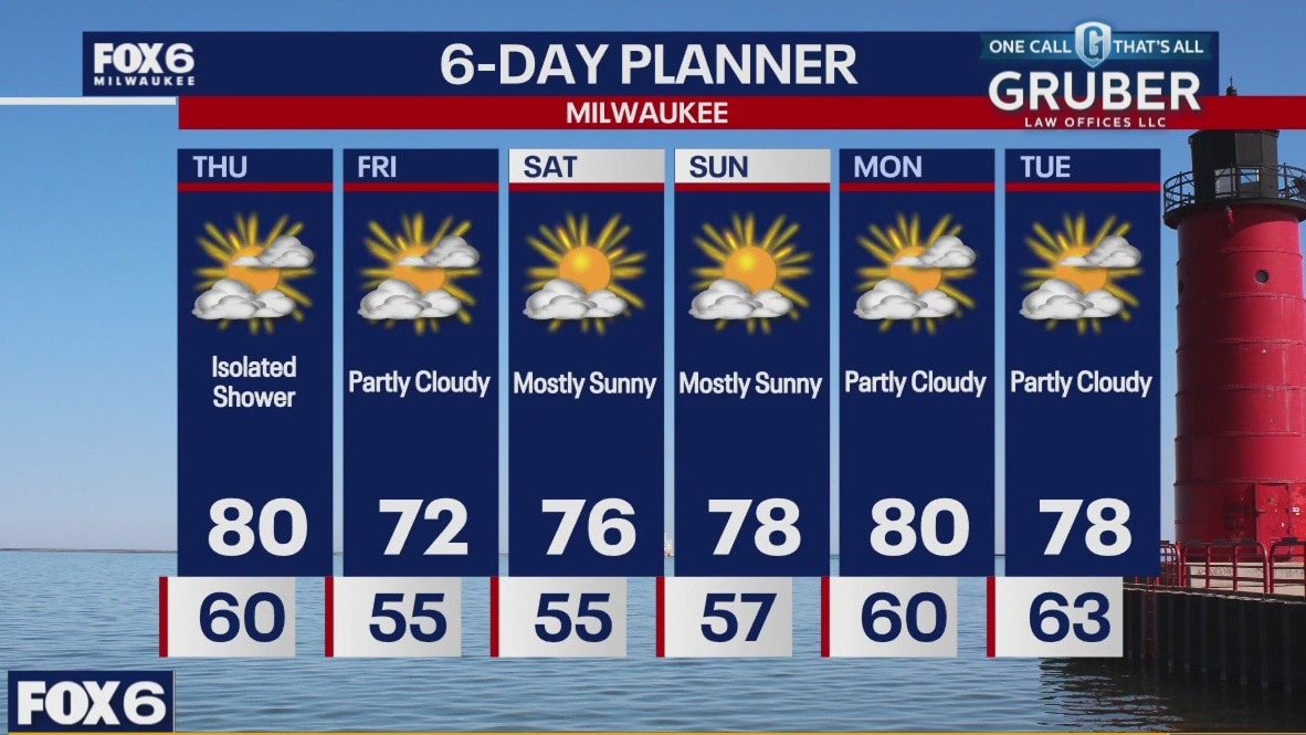
A cold front passes through Wisconsin today. Ahead of that front we warm into the upper 70s to near 80 and cool behind it to the low 70s tomorrow. With the frontal passage comes the chance for a few isolated showers but most areas will stay dry. We remain dry for the rest of the week and into early next week. Highs will remain just lightly below average and overnights will be refreshingly cool.
A cold front passes through Wisconsin today. Ahead of that front we warm into the upper 70s to near 80 and cool behind it to the low 70s tomorrow. With the frontal passage comes the chance for a few isolated showers but most areas will stay dry. We remain dry for the rest of the week and into early next week. Highs will remain just lightly below average and overnights will be refreshingly cool.
Weather Webcast with Chief Meteorologist Tom Wachs
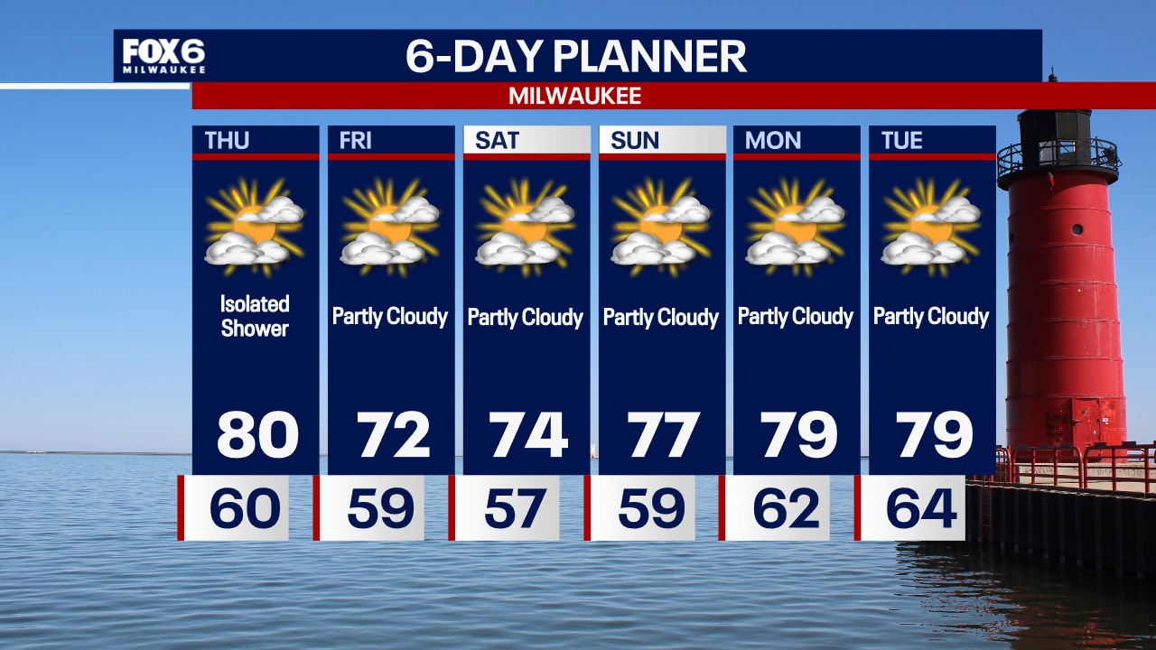
Quiet overnight with temperatures in the 50s to around 60 by sunrise. Partly to mostly cloudy on Thursday with an isolated afternoon rain shower possible. Highs around 80.
Quiet overnight with temperatures in the 50s to around 60 by sunrise. Partly to mostly cloudy on Thursday with an isolated afternoon rain shower possible. Highs around 80.


Tropical Storm Debby moves up East Coast as flood threat continues for Carolinas
Tropical Storm Debby is expected to make a second landfall in South Carolina sometime late Wednesday night, bringing intense winds along the South Carolina coast and parts of North Carolina.
Tropical Storm Debby is expected to make a second landfall in South Carolina sometime late Wednesday night, bringing intense winds along the South Carolina coast and parts of North Carolina.
Weather Webcast with Chief Meteorologist Tom Wachs
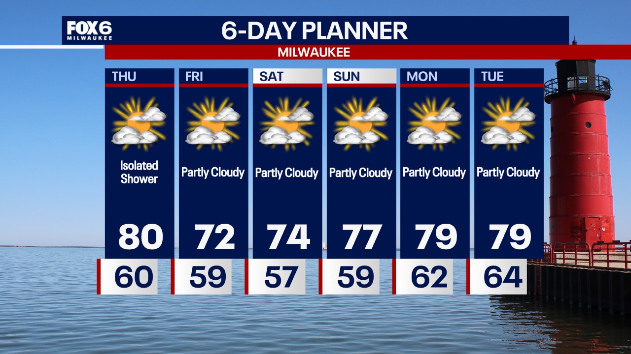
Becoming partly cloudy tonight. Temperatures dropping through the 60s. Partly to mostly cloudy on Thursday with a slim chance for a shower and a high around 80.
Becoming partly cloudy tonight. Temperatures dropping through the 60s. Partly to mostly cloudy on Thursday with a slim chance for a shower and a high around 80.

Weather webcast with Lisa Michaels
Mostly sunny and cooler on Wednesday with highs in the mid 70s near the lake to upper 70s inland. An approaching cold front on Thursday will bring in a few more clouds with temps reaching the low 80s. A slight chance for a shower in the afternoon. Below average temps and dry conditions for the rest of the week into the weekend.
Mostly sunny and cooler on Wednesday with highs in the mid 70s near the lake to upper 70s inland. An approaching cold front on Thursday will bring in a few more clouds with temps reaching the low 80s. A slight chance for a shower in the afternoon. Below average temps and dry conditions for the rest of the week into the weekend.


Here's how extreme heat is impacting electric bills
Last year Earth was 2.66 degrees warmer than it was before pre-industrial times. It may sound insignificant, but it can be harmful to human health.
Last year Earth was 2.66 degrees warmer than it was before pre-industrial times. It may sound insignificant, but it can be harmful to human health.
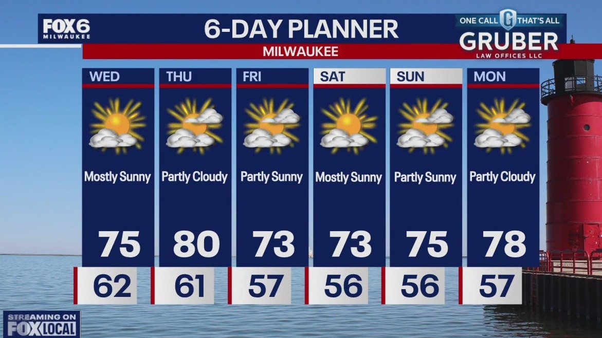
Weather webcast with Lisa Michaels
Clouds will continue to decrease tonight. Temps falling in the to upper 50s to low 60s by Wednesday morning. Mostly sunny and cooler on Wednesday with highs in the mid 70s near the lake to upper 70s inland. An approaching cold front on Thursday will bring in a few more clouds with temps reaching the low 80s. A slight chance for a shower in the afternoon. Below average temps and dry conditions for the rest of the week into the weekend.
Clouds will continue to decrease tonight. Temps falling in the to upper 50s to low 60s by Wednesday morning. Mostly sunny and cooler on Wednesday with highs in the mid 70s near the lake to upper 70s inland. An approaching cold front on Thursday will bring in a few more clouds with temps reaching the low 80s. A slight chance for a shower in the afternoon. Below average temps and dry conditions for the rest of the week into the weekend.
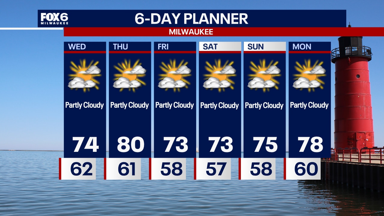
Weather Webcast with Chief Meteorologist Tom Wachs
Clearing skies overnight and comfortable. Lows in the mid-50s inland, low 60s near the lake. Partly sunny with lower humidity levels on Wednesday. Highs in the low-to-mid 70s.
Clearing skies overnight and comfortable. Lows in the mid-50s inland, low 60s near the lake. Partly sunny with lower humidity levels on Wednesday. Highs in the low-to-mid 70s.


Debby douses Southeast with rain as it moves along Atlantic coast
The latest forecast predicts Debby could restrengthen over the Atlantic Ocean and then move inland again near Charleston, South Carolina, by Thursday.
The latest forecast predicts Debby could restrengthen over the Atlantic Ocean and then move inland again near Charleston, South Carolina, by Thursday.
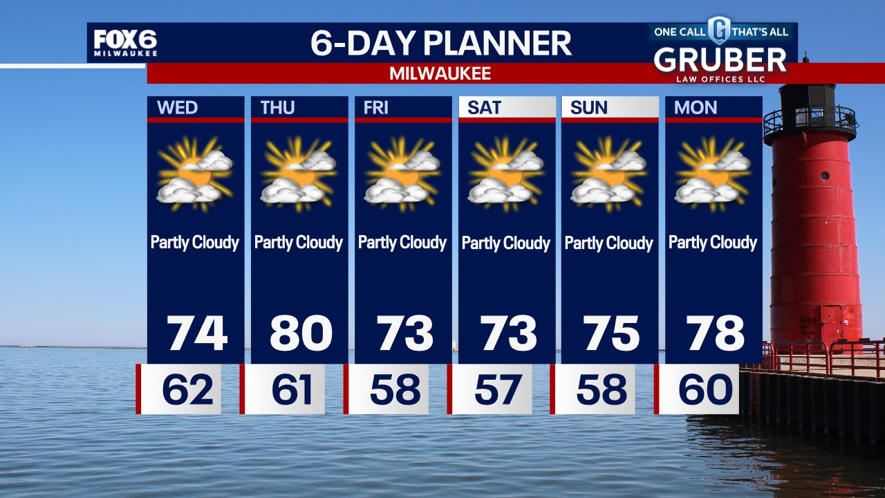
Weather Webcast with Chief Meteorologist Tom Wachs
Clearing skies and dropping humidity levels tonight. Temperatures will drop through the 60s this evening and into the 50s away from the lake overnight. Partly sunny on Wednesday with a high in the low-to-mid 70s.
Clearing skies and dropping humidity levels tonight. Temperatures will drop through the 60s this evening and into the 50s away from the lake overnight. Partly sunny on Wednesday with a high in the low-to-mid 70s.
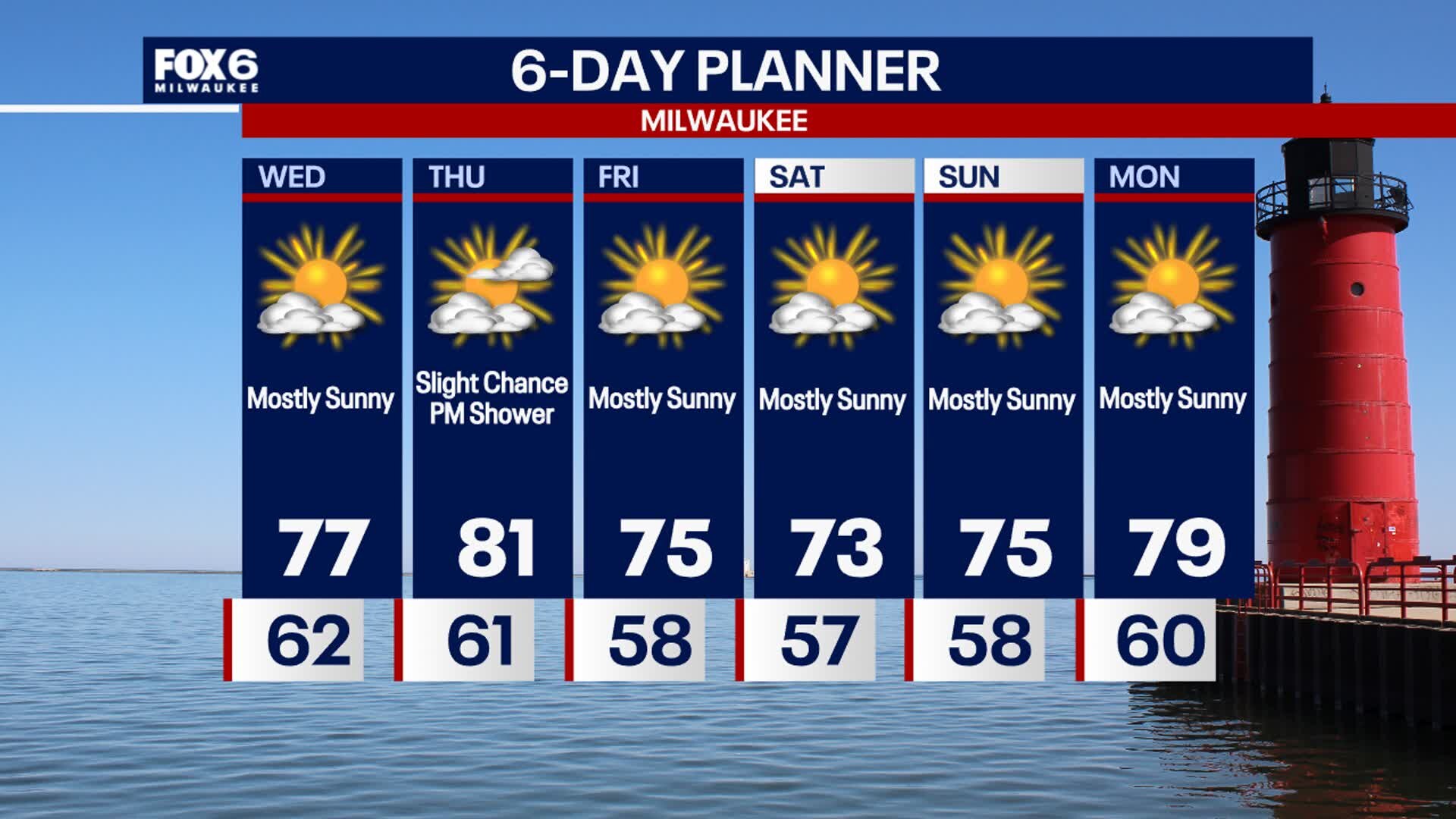
Weather webcast with Lisa Michaels
Clearing skies tonight as high pressure moves in. Temperatures dropping through the 60s this evening and settling in the 50s inland overnight, low 60s near the lake. Partly sunny on Wednesday with highs in the mid-70s and comfortable dew points in the 50s. Warming up on Thursday with a touch of humidity. High around 80 with dew points in the low 60s. A cold front will move through on Thursday. Cooler and less humid Friday into the weekend. Highs in the 70s with dew points in the 50s. No major storm systems in sight.
Clearing skies tonight as high pressure moves in. Temperatures dropping through the 60s this evening and settling in the 50s inland overnight, low 60s near the lake. Partly sunny on Wednesday with highs in the mid-70s and comfortable dew points in the 50s. Warming up on Thursday with a touch of humidity. High around 80 with dew points in the low 60s. A cold front will move through on Thursday. Cooler and less humid Friday into the weekend. Highs in the 70s with dew points in the 50s. No major storm systems in sight.
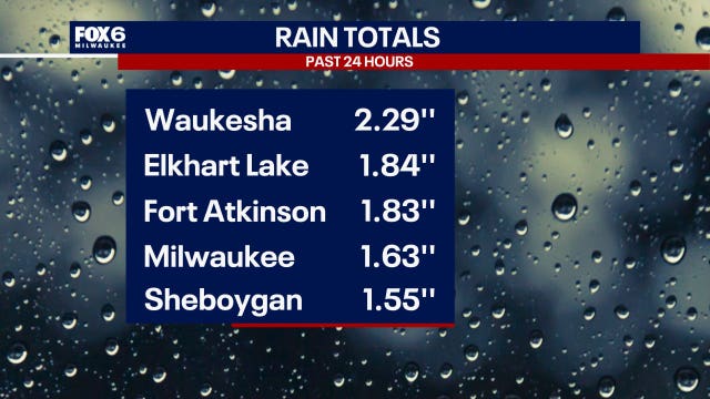

Southeast WI rainfall totals; storms on Tuesday, Aug. 6
The FOX6 Weather Experts and the National Weather Service have been collecting data on rainfall totals associated with the storms that pushed through southeast Wisconsin on Tuesday, Aug. 6.
The FOX6 Weather Experts and the National Weather Service have been collecting data on rainfall totals associated with the storms that pushed through southeast Wisconsin on Tuesday, Aug. 6.

Weather webcast with Rob Haswell
Rain and thunderstorms winding down early this morning and clearing to partly sunny conditions later today. Much cooler today with highs in the upper 60s and low 70s. A few dry days ahead with a stretch of cooler than average temperatures. Highs will be in the upper 70s to near 80 from Wednesday through Sunday. Our next significant chance for rain might not come until late next week.
Rain and thunderstorms winding down early this morning and clearing to partly sunny conditions later today. Much cooler today with highs in the upper 60s and low 70s. A few dry days ahead with a stretch of cooler than average temperatures. Highs will be in the upper 70s to near 80 from Wednesday through Sunday. Our next significant chance for rain might not come until late next week.

Weather webcast with Lisa Michaels
Cloudy tonight with widespread heavy rain and storms moving in late. Activity will continue into early Tuesday morning. Isolated strong to severe storms possible with gusty winds and hail. The main threat will be heavy rain that can lead to flooding. Rain/storms clear out on Tuesday with cool temps in the upper 60s. Looking dry the rest of the week with highs in the 70s. Cooler and more comfortable!
Cloudy tonight with widespread heavy rain and storms moving in late. Activity will continue into early Tuesday morning. Isolated strong to severe storms possible with gusty winds and hail. The main threat will be heavy rain that can lead to flooding. Rain/storms clear out on Tuesday with cool temps in the upper 60s. Looking dry the rest of the week with highs in the 70s. Cooler and more comfortable!


Wisconsin severe weather: Flood watch canceled, thousands without power
The flood watch has been canceled although spotty showers and storms will continue on Tuesday morning, Aug. 6.
The flood watch has been canceled although spotty showers and storms will continue on Tuesday morning, Aug. 6.


Watch: Waterspout comes ashore in downtown Buffalo, causing tornado damage
Video from the National Weather Service Buffalo office shows the vortex spinning in Lake Erie and then coming onshore in LaSalle Park. According to Erie County, the waterspout continued onto Niagara Street where it ripped off the roof of a building.
Video from the National Weather Service Buffalo office shows the vortex spinning in Lake Erie and then coming onshore in LaSalle Park. According to Erie County, the waterspout continued onto Niagara Street where it ripped off the roof of a building.