

Weather webcast with Rob Haswell
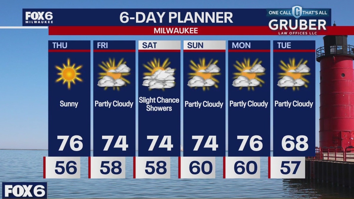
Another sunny and warm day today with highs in the mid to upper 70s. Hurricane Helene will make landfall along Florida's "Big Bend" region tonight and then move north as it weakens. What is left of that system will give us a few clouds later in the day on Friday and a slight chance of showers as well as windy conditions on Saturday. We should dry up later Sunday into Monday. Cooler air arrives next week.
Another sunny and warm day today with highs in the mid to upper 70s. Hurricane Helene will make landfall along Florida's "Big Bend" region tonight and then move north as it weakens. What is left of that system will give us a few clouds later in the day on Friday and a slight chance of showers as well as windy conditions on Saturday. We should dry up later Sunday into Monday. Cooler air arrives next week.
Weather Webcast with Chief Meteorologist Tom Wachs
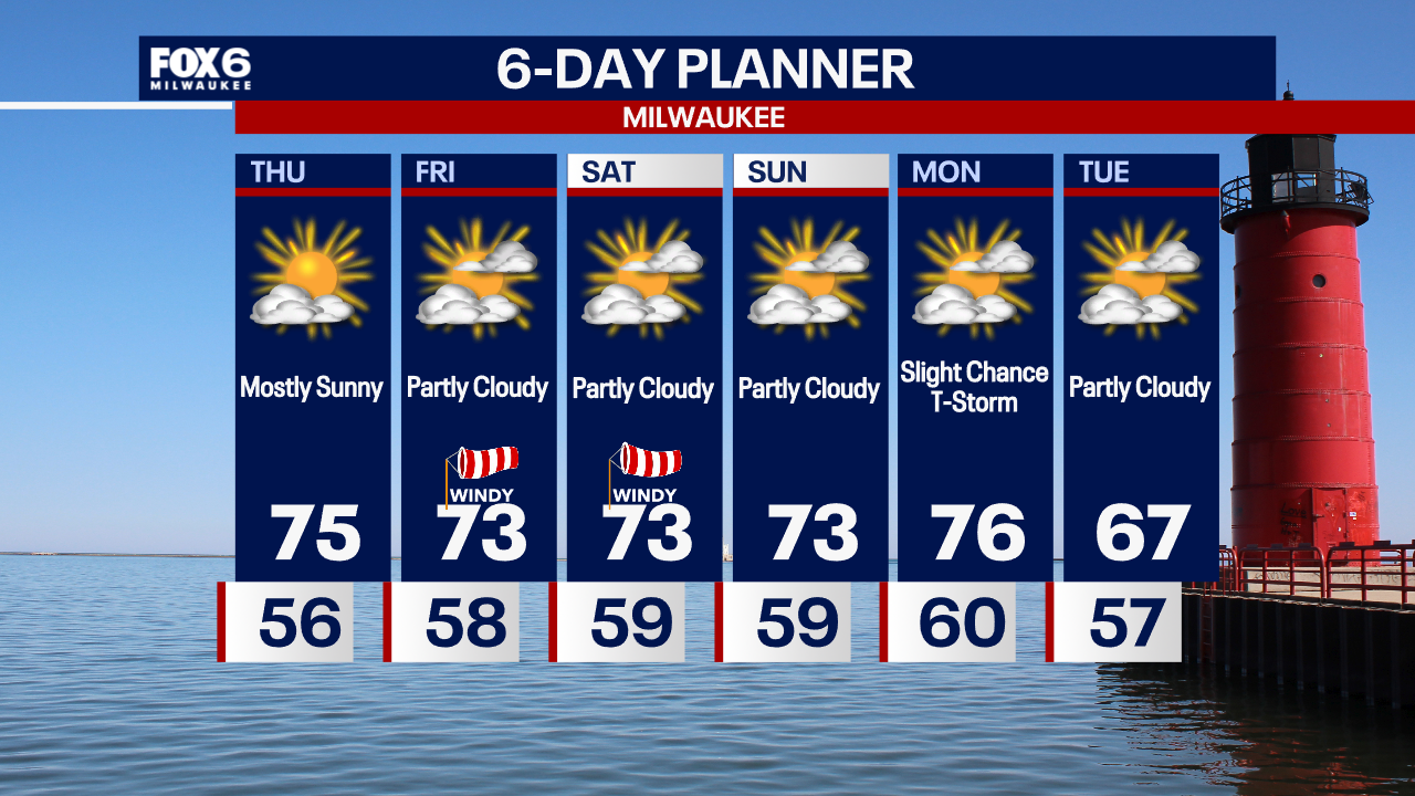
Mostly clear overnight with temperatures in the 50s. Mostly sunny on Thursday with highs in the 70s.
Mostly clear overnight with temperatures in the 50s. Mostly sunny on Thursday with highs in the 70s.
Weather Webcast with Chief Meteorologist Tom Wachs
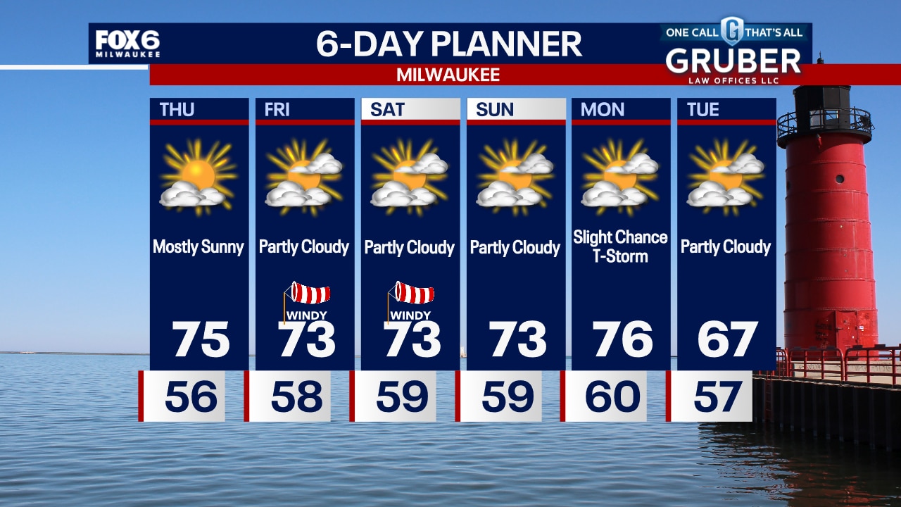
Mostly clear tonight with temperatures dropping through the 60s. More sun on the way Thursday with highs in the mid-70s.
Mostly clear tonight with temperatures dropping through the 60s. More sun on the way Thursday with highs in the mid-70s.

Where does Helene go after hitting Florida? Southeast, mid-Atlantic could see 'catastrophic' flooding
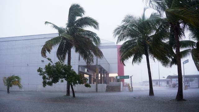
The large storm will bring widespread heavy rain, damaging wind and possible tornadoes to cities in the Southeast, including Atlanta and Asheville, North Carolina.
The large storm will bring widespread heavy rain, damaging wind and possible tornadoes to cities in the Southeast, including Atlanta and Asheville, North Carolina.
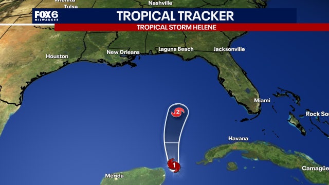

Hurricane Helene and the Fujiwhara Effect; will it impact Wisconsin?
Hurricane season continues with "rare phenomenon".
Hurricane season continues with "rare phenomenon".
Weather Webcast with Stephanie Barichello
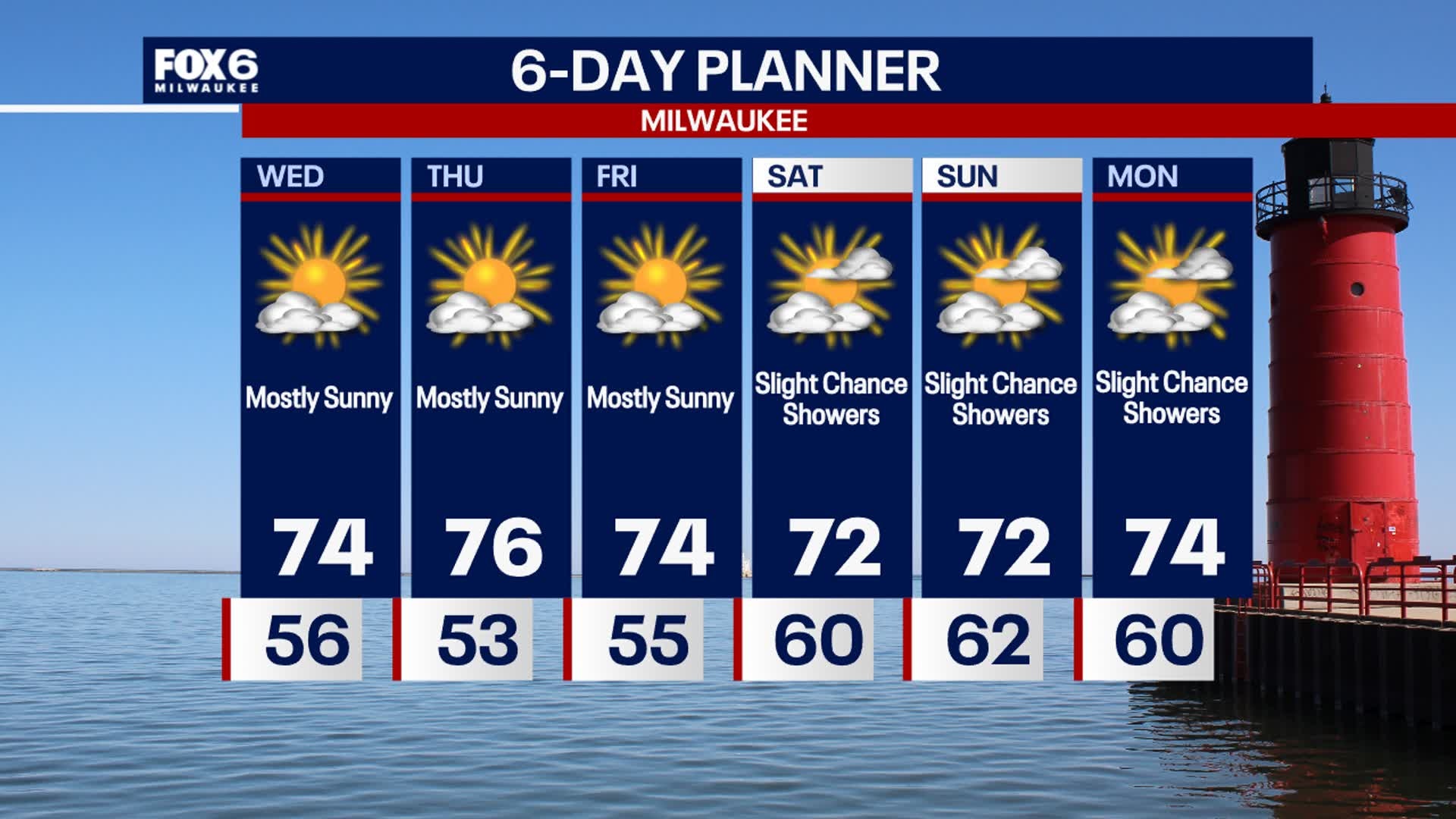
Sunshine sticks around the rest of the week! Daytime highs will be pleasant in the 70s, but nighttime lows will be cool in the 40s and 50s. Slight chance for rain over the weekend, as the remnants of Helene may stay south of WI.
Sunshine sticks around the rest of the week! Daytime highs will be pleasant in the 70s, but nighttime lows will be cool in the 40s and 50s. Slight chance for rain over the weekend, as the remnants of Helene may stay south of WI.

Live updates: Tropical Storm Helene nears hurricane strength in Caribbean on trek to Florida
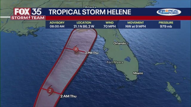
Tropical Storm Helene is nearing hurricane strength just offshore of the northeastern coast of the Yucatan Peninsula toward the Gulf of Mexico, according to the National Hurricane Center (NHC). It's expected to become a major hurricane (Category 3 or higher) before making landfall in Florida's Big Bend region on Thursday.
Tropical Storm Helene is nearing hurricane strength just offshore of the northeastern coast of the Yucatan Peninsula toward the Gulf of Mexico, according to the National Hurricane Center (NHC). It's expected to become a major hurricane (Category 3 or higher) before making landfall in Florida's Big Bend region on Thursday.
Weather webcast with Rob Haswell
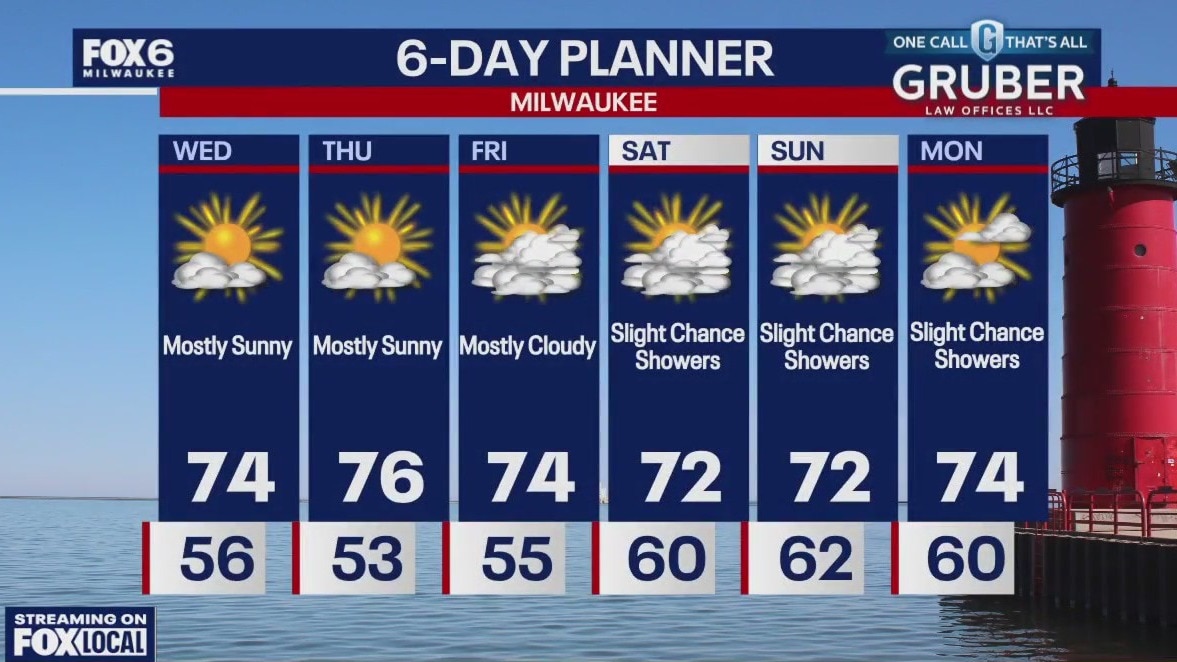
Yesterday's low is pushing farther to the east and an area of high pressure building across the upper Midwest to bring sunshine and warmer temperatures. We will be dry to day with highs in the low to mid 70s and warm to the upper 70s Thursday. There is still a chance for showers on the weekend but we are trending drier as the remnants of Helene may not reach us in as significant a way as was originally forecast.
Yesterday's low is pushing farther to the east and an area of high pressure building across the upper Midwest to bring sunshine and warmer temperatures. We will be dry to day with highs in the low to mid 70s and warm to the upper 70s Thursday. There is still a chance for showers on the weekend but we are trending drier as the remnants of Helene may not reach us in as significant a way as was originally forecast.
Weather Webcast with Chief Meteorologist Tom Wachs
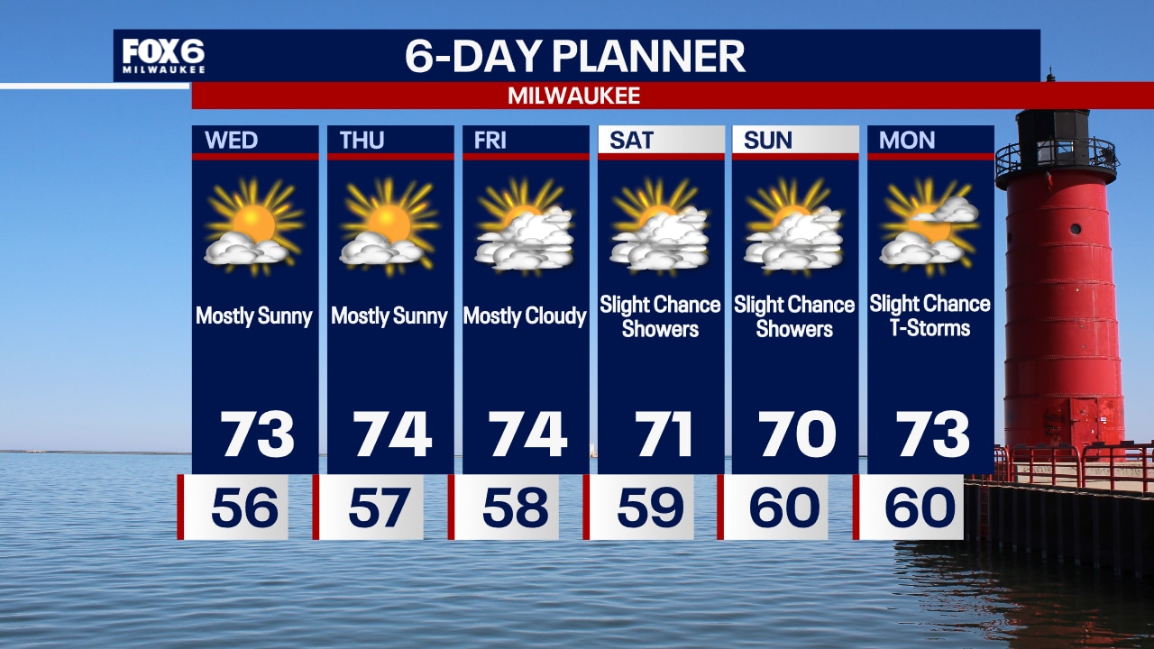
Drizzle ending overnight with patchy fog and temperatures in the 50s. Mostly sunny on Wednesday and Thursday with highs in the low-to-mid 70s.
Drizzle ending overnight with patchy fog and temperatures in the 50s. Mostly sunny on Wednesday and Thursday with highs in the low-to-mid 70s.
Weather Webcast with Chief Meteorologist Tom Wachs
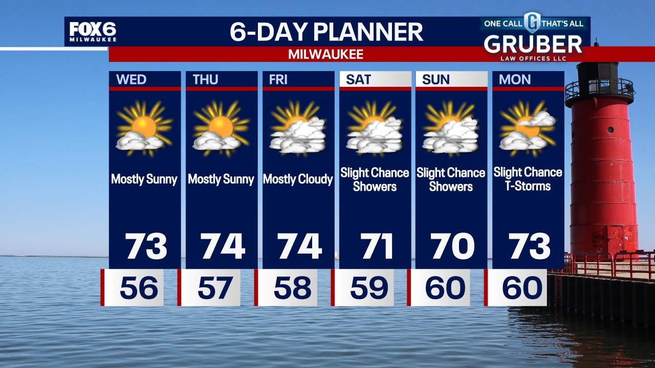
Rain will taper off late this evening with patchy fog overnight. Temperatures dropping into the 50s. Mostly sunny on Wednesday with highs in the low-to-mid 70s.
Rain will taper off late this evening with patchy fog overnight. Temperatures dropping into the 50s. Mostly sunny on Wednesday with highs in the low-to-mid 70s.
Weather Webcast with Stephanie Barichello
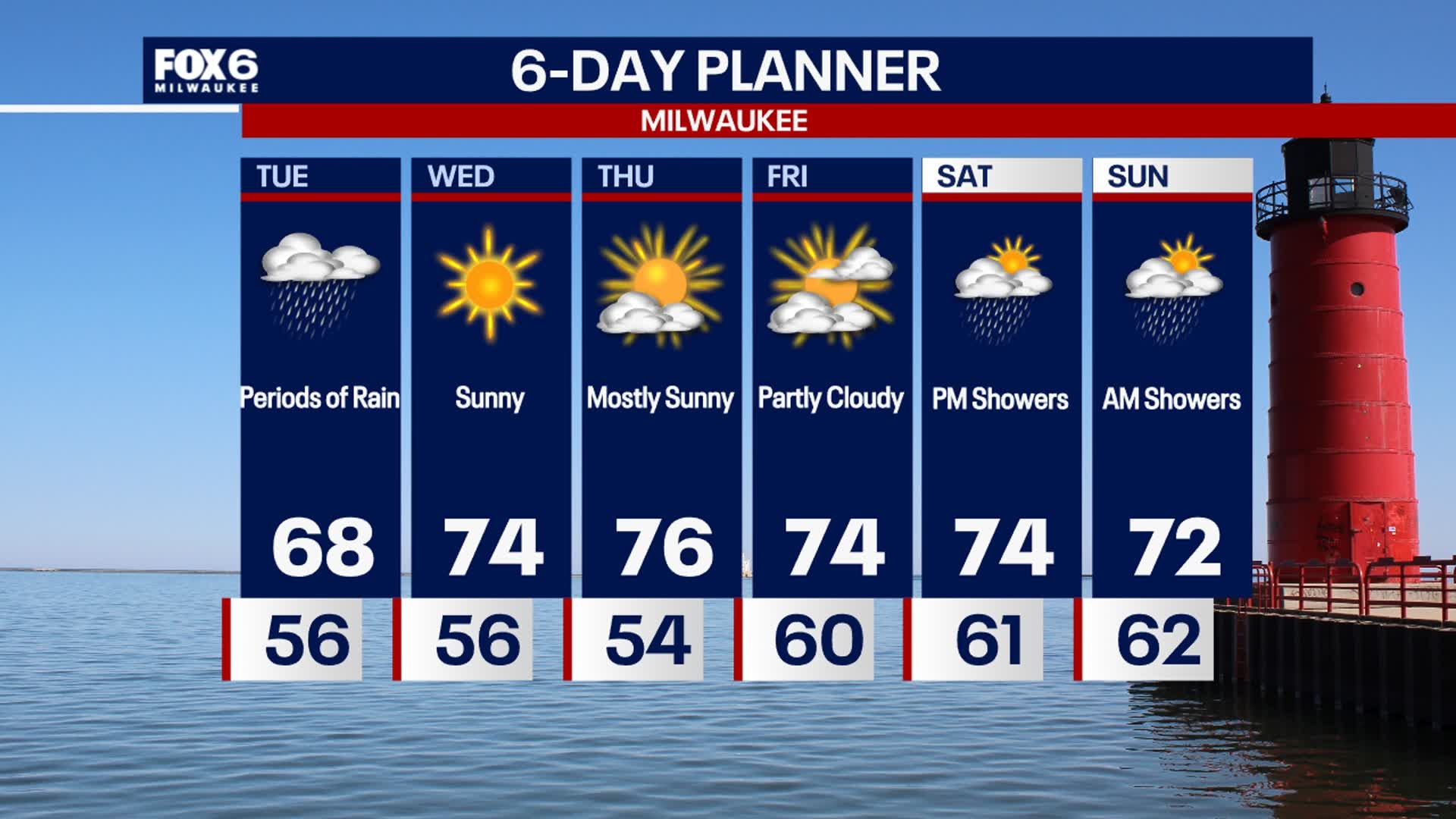
Scattered showers continue this afternoon, keeping temperatures cool in the mid to upper 60s. Drying out overnight then sunshine and 70s expected the rest of the week. There is another chance for rain over the weekend, especially late Saturday into Sunday, only if the remnants of a tropical storm reach us.
Scattered showers continue this afternoon, keeping temperatures cool in the mid to upper 60s. Drying out overnight then sunshine and 70s expected the rest of the week. There is another chance for rain over the weekend, especially late Saturday into Sunday, only if the remnants of a tropical storm reach us.

Southeast Wisconsin rain Tuesday; waterspouts possible
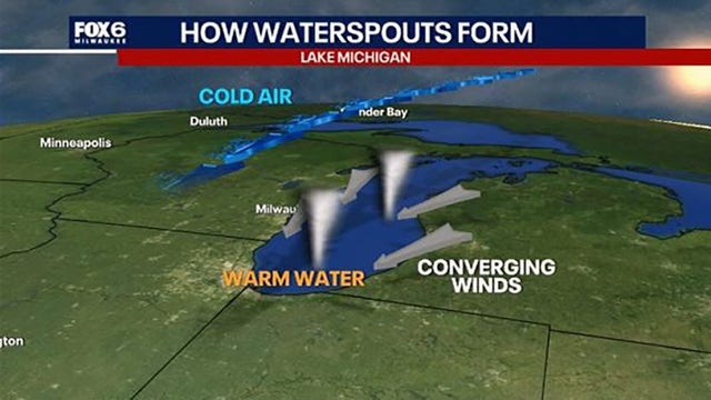
A low pressure system on Tuesday brings a chance for thunderstorms and waterspouts over the southern part of Lake Michigan.
A low pressure system on Tuesday brings a chance for thunderstorms and waterspouts over the southern part of Lake Michigan.
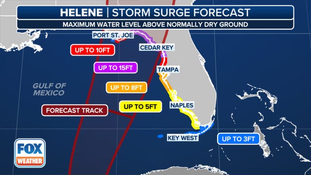

Mapped: Where Florida’s Gulf Coast is susceptible to Helene storm surge
Given Florida’s distinctive coastline, its topography makes it particularly vulnerable to storm surge flooding during hurricanes and other significant storm systems.
Given Florida’s distinctive coastline, its topography makes it particularly vulnerable to storm surge flooding during hurricanes and other significant storm systems.
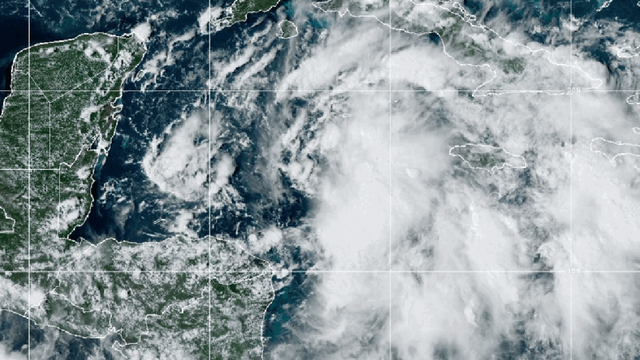

Florida storm live updates: Watches expand as Potential Tropical Cyclone Nine expected to strengthen
Potential Tropical Cyclone Nine formed in the northwestern Caribbean Sea on Monday morning and is forecast to become a hurricane later this week, according to the National Hurricane Center (NHC).
Potential Tropical Cyclone Nine formed in the northwestern Caribbean Sea on Monday morning and is forecast to become a hurricane later this week, according to the National Hurricane Center (NHC).
Weather webcast with Rob Haswell
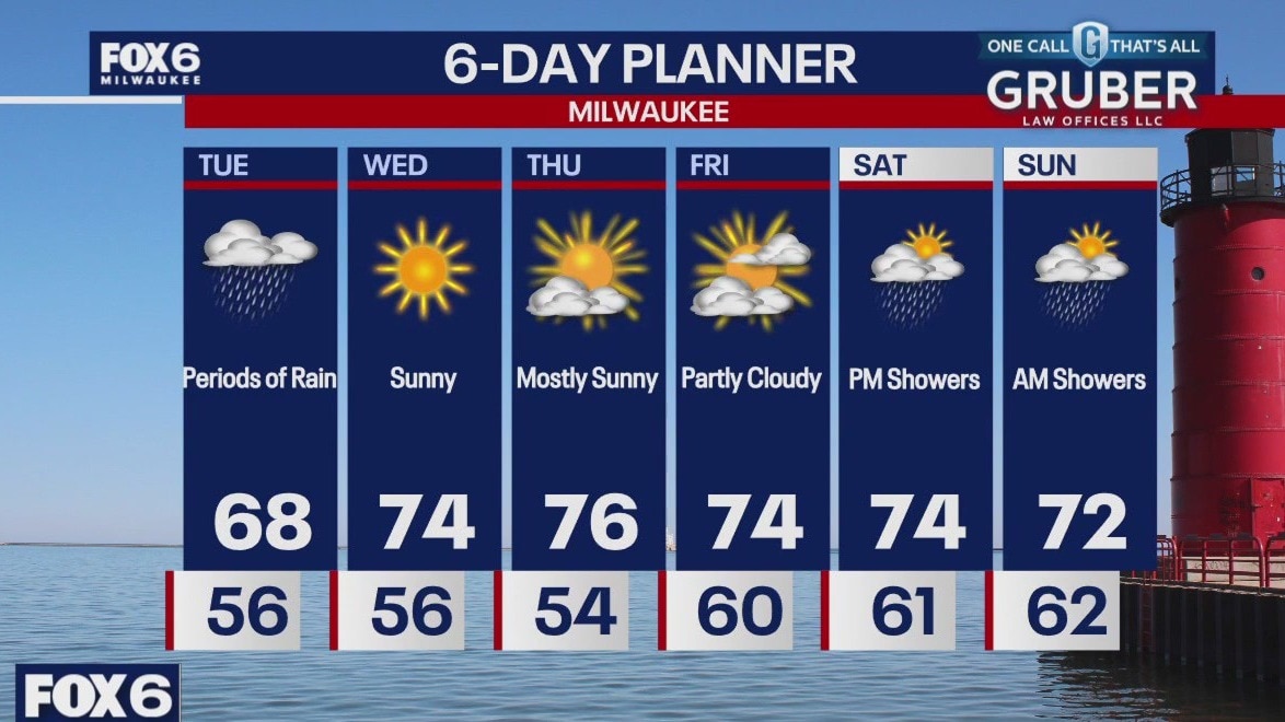
An area of low pressure will move through our region today with Wisconsin on its far northwest corner. Periods of rain are expected with the highest amounts likely in the farther southeast corner of the state. Highs will gain under perform slightly with upper 60s likely but after today we warm into the 70s for a few days. Sun returns tomorrow through Friday but then rain takes over again for the weekend.
An area of low pressure will move through our region today with Wisconsin on its far northwest corner. Periods of rain are expected with the highest amounts likely in the farther southeast corner of the state. Highs will gain under perform slightly with upper 60s likely but after today we warm into the 70s for a few days. Sun returns tomorrow through Friday but then rain takes over again for the weekend.
Weather webcast with Lisa Michaels
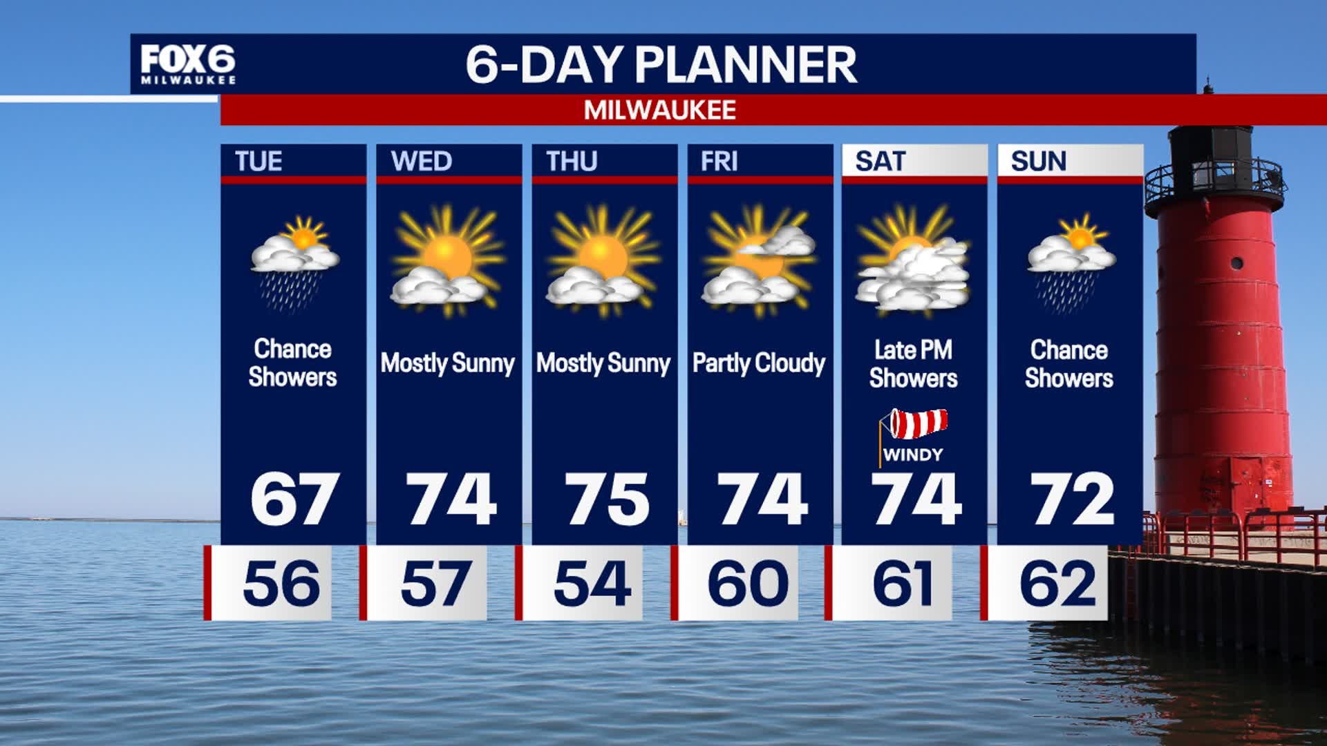
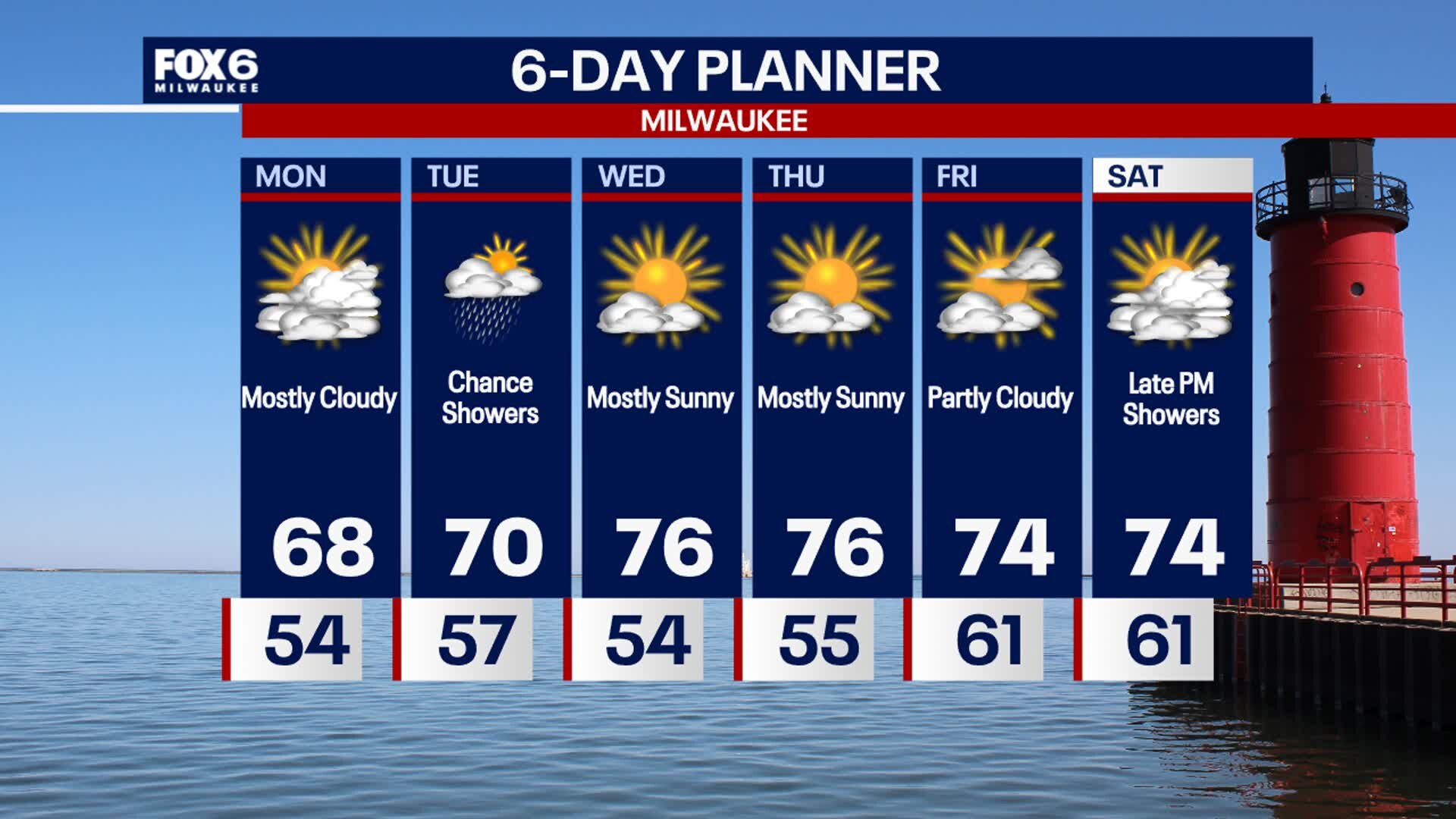
Mostly cloudy this evening with temperatures dropping into the 50s. Possible fog by Tuesday morning. Cool again Tuesday with temps in the upper 60s. Chance for showers, especially south and lakeside, as a system passes mainly east. Dry and slightly warmer Wednesday through Friday. Highs in the low to mid 70s. There is another chance for showers late Saturday into Sunday, thanks to potential remnants of a tropical storm. Stay tuned on the latest storm track.
Mostly cloudy this evening with temperatures dropping into the 50s. Possible fog by Tuesday morning. Cool again Tuesday with temps in the upper 60s. Chance for showers, especially south and lakeside, as a system passes mainly east. Dry and slightly warmer Wednesday through Friday. Highs in the low to mid 70s. There is another chance for showers late Saturday into Sunday, thanks to potential remnants of a tropical storm. Stay tuned on the latest storm track.
Weather Webcast with Stephanie Barichello
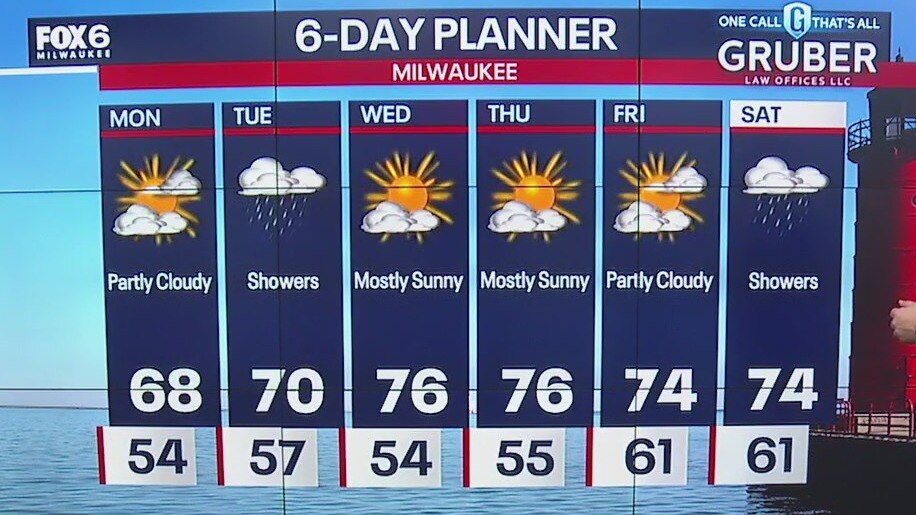
Increasing clouds this afternoon with a chance for showers returning on Tuesday, especially lakeside and south. It won't be a washout like Sunday was but keep an umbrella with you throughout the day. Sunshine returns Wednesday and lasts the rest of the week. Could see a few more showers this weekend.
Increasing clouds this afternoon with a chance for showers returning on Tuesday, especially lakeside and south. It won't be a washout like Sunday was but keep an umbrella with you throughout the day. Sunshine returns Wednesday and lasts the rest of the week. Could see a few more showers this weekend.
Weather webcast with Rob Haswell
Drying up for a few hours today as high pressure builds over the area. Highs will be in the upper 60s with a breezy NE wind. That wind will also contribute to a Beach Hazards Statement today.
Drying up for a few hours today as high pressure builds over the area. Highs will be in the upper 60s with a breezy NE wind. That wind will also contribute to a Beach Hazards Statement today.

Weather Webcast with Holly Baker
SE Wisconsin received a lot of rain to start off the first day of fall. More rain and a change in temperatures are on the way.
SE Wisconsin received a lot of rain to start off the first day of fall. More rain and a change in temperatures are on the way.

Weather webcast with Lisa Michaels
First day of Fall is today! Rain and embedded storms early Sunday with lingering rain through the afternoon. Highs earlier in the day reaching the upper 60s to low 70s.
First day of Fall is today! Rain and embedded storms early Sunday with lingering rain through the afternoon. Highs earlier in the day reaching the upper 60s to low 70s.