


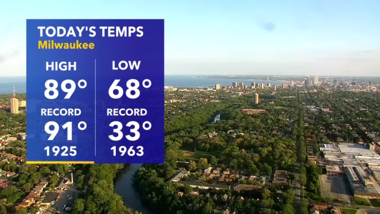
'Pneumonia Front' Sunday
A strong backdoor cold front is in the forecast Sunday! Expect a 20 degree drop in temps!
A strong backdoor cold front is in the forecast Sunday! Expect a 20 degree drop in temps!
Weather Webcast with A.J. Waterman
Hottest day of the year so far on Saturday, but a much different story Sunday...
Hottest day of the year so far on Saturday, but a much different story Sunday...
Weather webcast with Eric Manges
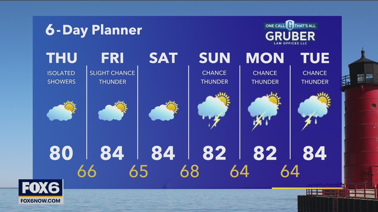
Partly cloudy skies and very warm this afternoon with high temps getting into the mid-80s for most. Big changes Sunday afternoon as high temps quickly fall in the afternoon as cold air rushes in giving us a shot and more scattered showers and storms.
Partly cloudy skies and very warm this afternoon with high temps getting into the mid-80s for most. Big changes Sunday afternoon as high temps quickly fall in the afternoon as cold air rushes in giving us a shot and more scattered showers and storms.

Weather webcast with Rob Haswell
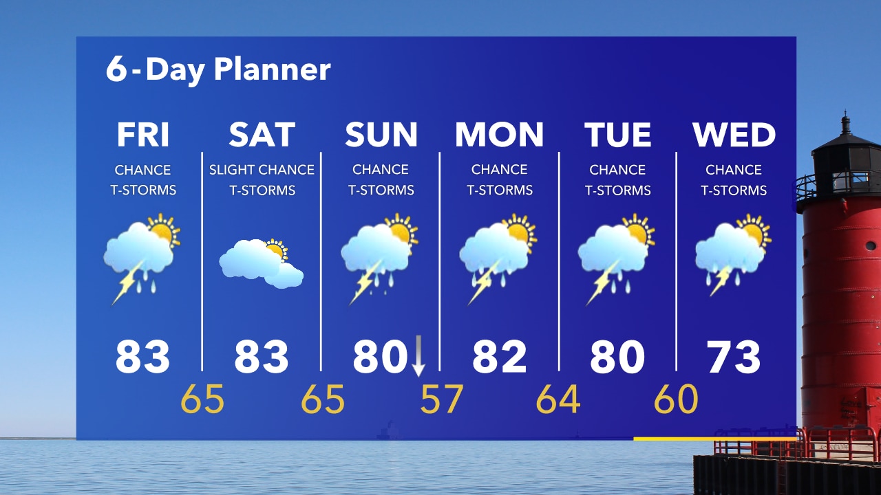
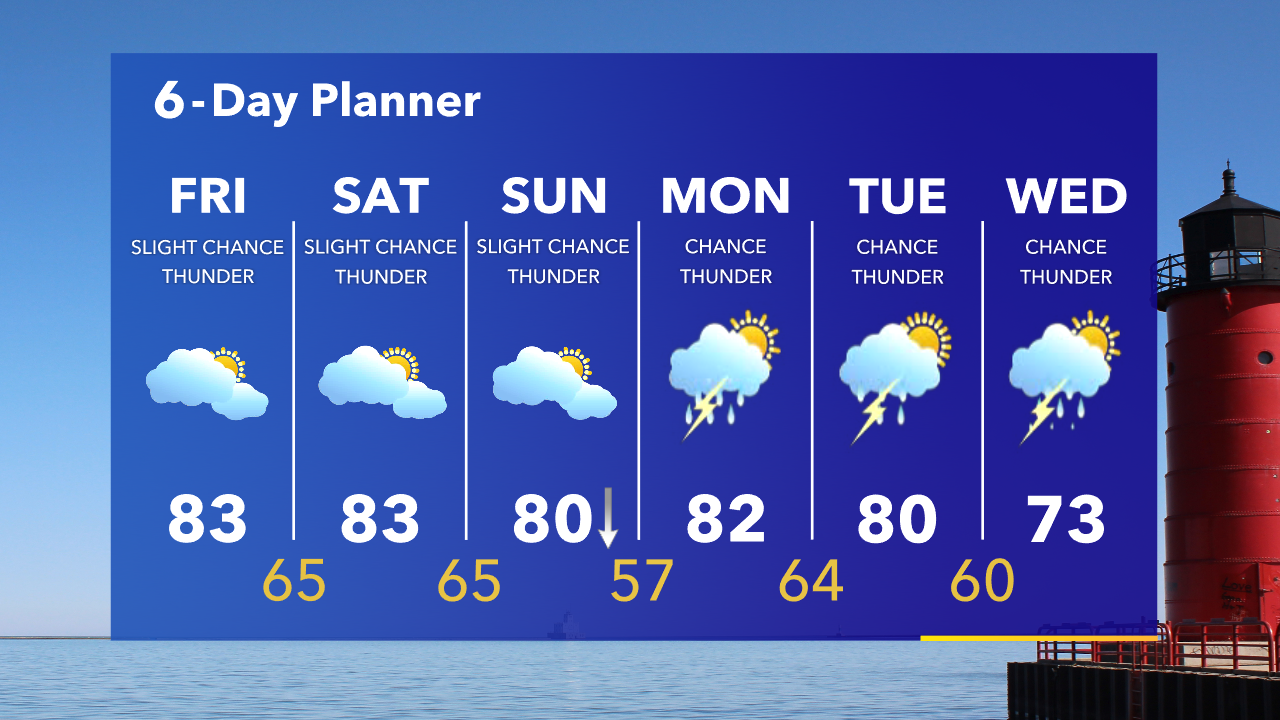
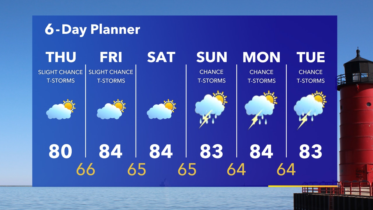
Partly sunny to start our Friday with more clouds and a chance for showers and isolated thunderstorms this afternoon. Hot again today with highs in the low 80s. We warm to the mid 80s tomorrow with just a slight chance for showers or thunderstorms.
Partly sunny to start our Friday with more clouds and a chance for showers and isolated thunderstorms this afternoon. Hot again today with highs in the low 80s. We warm to the mid 80s tomorrow with just a slight chance for showers or thunderstorms.
Weather Webcast with Tom Wachs
Mostly cloudy overnight with temperatures in the 60s. Another warm and breezy day on Friday with highs in the upper 70s to low 80s. A few scattered t-storms are possible later in the day.
Mostly cloudy overnight with temperatures in the 60s. Another warm and breezy day on Friday with highs in the upper 70s to low 80s. A few scattered t-storms are possible later in the day.
Weather Webcast with Tom Wachs
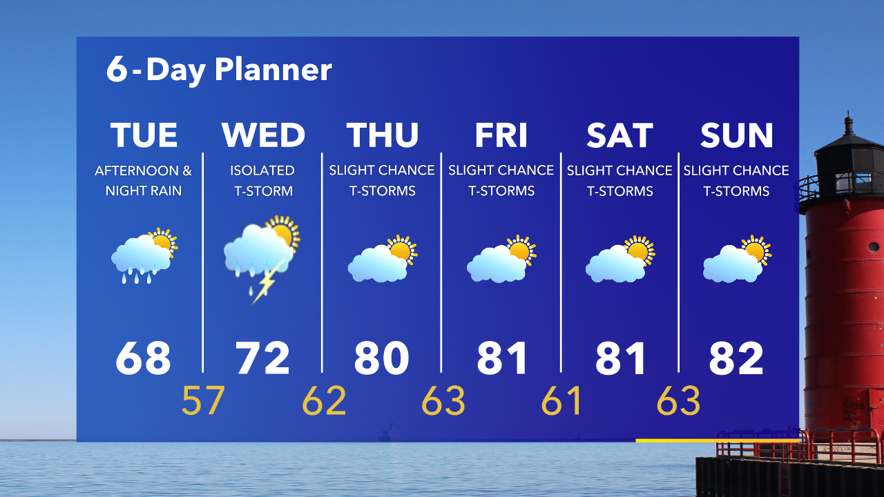
Warm tonight with temperatures gradually falling into the 60s. Mostly cloudy with a slight chance for a t-storm on Friday. Highs in the low 80s. 80s through the weekend with a pneumonia front Sunday afternoon.
Warm tonight with temperatures gradually falling into the 60s. Mostly cloudy with a slight chance for a t-storm on Friday. Highs in the low 80s. 80s through the weekend with a pneumonia front Sunday afternoon.
Weather webcast with Rob Haswell
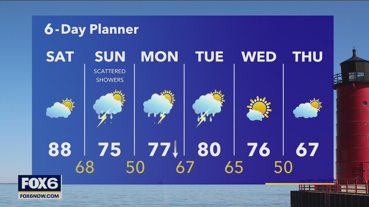
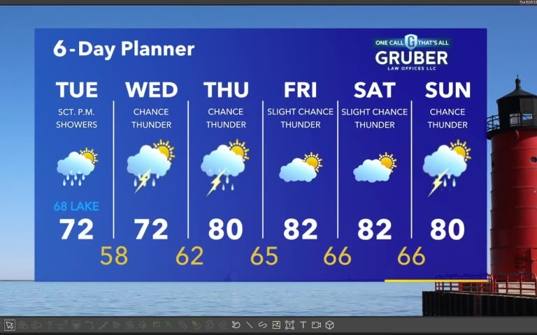
Warming to the low 80s today and getting humid! There is a slight chance for a few showers but mostly dry overall. We stay very warm even overnight and then get into the mid 80s tomorrow with a slight chance for showers and thunderstorms. The weekend will be a split with some sun and lots of heat on Saturday and showers and thunderstorms on Sunday.
Warming to the low 80s today and getting humid! There is a slight chance for a few showers but mostly dry overall. We stay very warm even overnight and then get into the mid 80s tomorrow with a slight chance for showers and thunderstorms. The weekend will be a split with some sun and lots of heat on Saturday and showers and thunderstorms on Sunday.

Weather Webcast with Tom Wachs
Partly cloudy and warm overnight. Temperatures in the low-to-mid 60s by sunrise. Warm on Thursday with a slight chance for a t-storm. Highs in the upper 70s to low 80s.
Partly cloudy and warm overnight. Temperatures in the low-to-mid 60s by sunrise. Warm on Thursday with a slight chance for a t-storm. Highs in the upper 70s to low 80s.
Weather Webcast with Tom Wachs
An isolated shower or t-storm possible this evening otherwise mild. Temperatures in the 60s all night. The heat moves in on Thursday with a high around 80.
An isolated shower or t-storm possible this evening otherwise mild. Temperatures in the 60s all night. The heat moves in on Thursday with a high around 80.

Forecast from Meteorologist Stephanie Barichello
Mostly cloudy this afternoon with some drizzle or an isolated thunderstorm. Temperatures will top out in the 70s. 80s tomorrow and the rest of the week, with a slight chance for a few thunderstorms each day.
Mostly cloudy this afternoon with some drizzle or an isolated thunderstorm. Temperatures will top out in the 70s. 80s tomorrow and the rest of the week, with a slight chance for a few thunderstorms each day.
Weather webcast with Rob Haswell
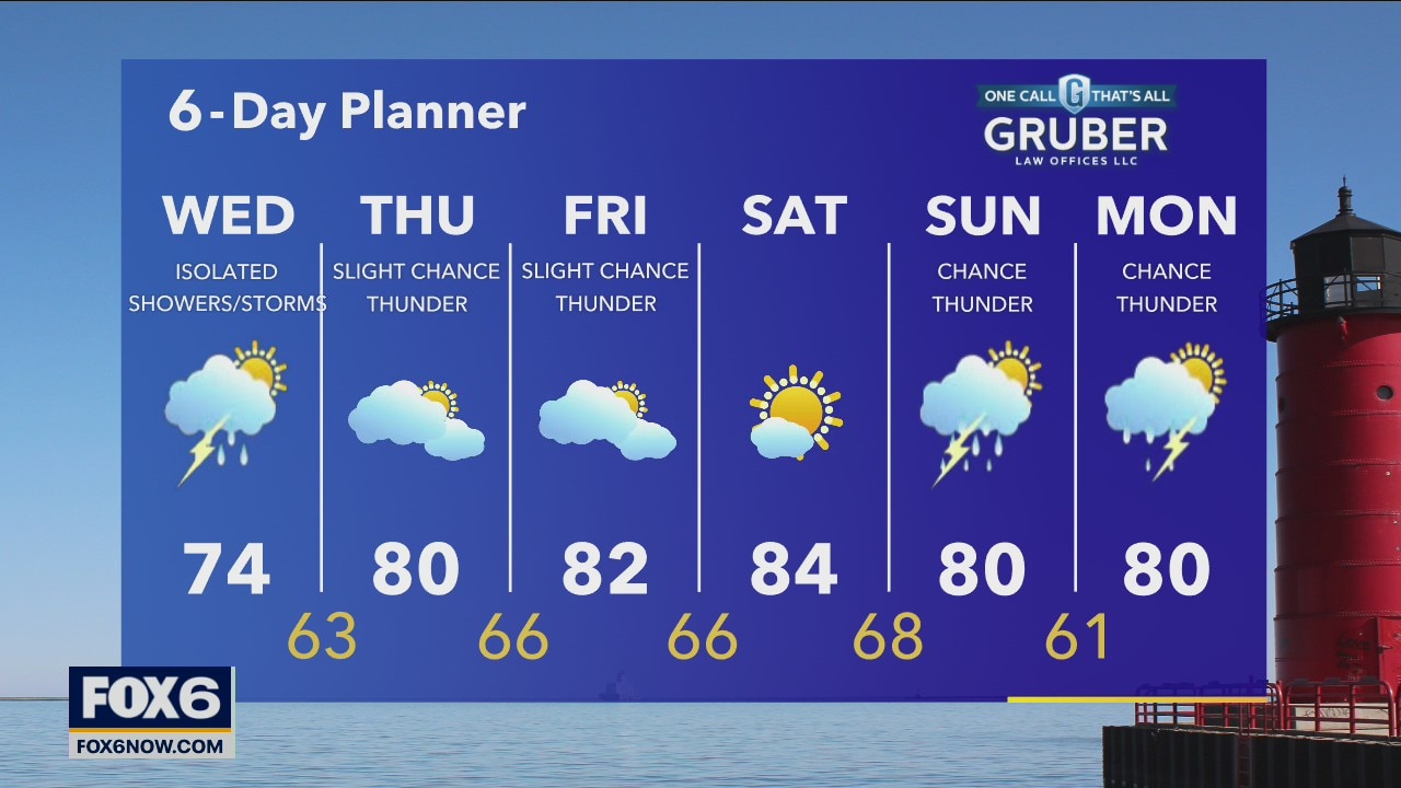
Light rain this morning tapering off to scattered showers this afternoon. Highs will be in the low to mid 70s. A bit warm up starts tomorrow with highs in the low 80s through the remainder of the week and into early next week. We continue to see a few chances for showers and thunderstorms most days but none will be all day rain.
Light rain this morning tapering off to scattered showers this afternoon. Highs will be in the low to mid 70s. A bit warm up starts tomorrow with highs in the low 80s through the remainder of the week and into early next week. We continue to see a few chances for showers and thunderstorms most days but none will be all day rain.
Weather Webcast with Tom Wachs
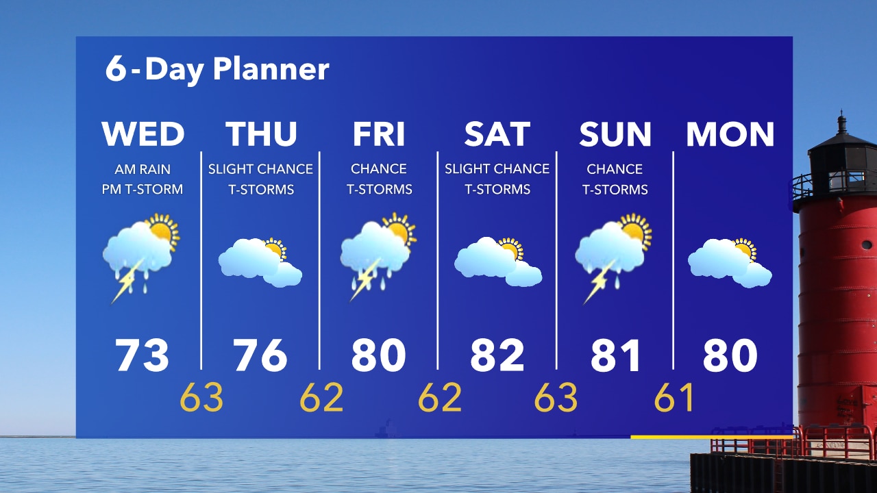
Light rain continues overnight. Temperatures in the upper 50s to low 60s by sunrise. Morning rain on Wednesday followed by a chance for an isolated t-storm Wednesday afternoon. Highs in the low-to-mid 70s.
Light rain continues overnight. Temperatures in the upper 50s to low 60s by sunrise. Morning rain on Wednesday followed by a chance for an isolated t-storm Wednesday afternoon. Highs in the low-to-mid 70s.

Weather Webcast with Tom Wachs
A rainy night is in the forecast. Temperatures in the 60s tonight. Morning rain on Wednesday with a chance for an isolated afternoon t-storm. Highs in the middle 70s. Warming into the 80s late in the week.
A rainy night is in the forecast. Temperatures in the 60s tonight. Morning rain on Wednesday with a chance for an isolated afternoon t-storm. Highs in the middle 70s. Warming into the 80s late in the week.
Forecast from Meteorologist Stephanie Barichello
Scattered showers possible this afternoon and evening with temperatures in the 60s and 70s. A chance for thunderstorms lingers into the weekend.
Scattered showers possible this afternoon and evening with temperatures in the 60s and 70s. A chance for thunderstorms lingers into the weekend.

Weather webcast with Rob Haswell
We continue to warm up over the next few days with several rounds of rain and a few chances for thunderstorms.
We continue to warm up over the next few days with several rounds of rain and a few chances for thunderstorms.

Weather Webcast with Tom Wachs
Increasing clouds overnight with temperatures in the 50s. Mostly cloudy on Tuesday with steady rain holding off until after 3pm.
Increasing clouds overnight with temperatures in the 50s. Mostly cloudy on Tuesday with steady rain holding off until after 3pm.
Weather Webcast with Tom Wachs
Mostly clear to partly cloudy tonight. Temperatures will drop into the 50s overnight. Rain moves in Tuesday afternoon/evening with highs in the upper 60s. 80s return late in the week.
Mostly clear to partly cloudy tonight. Temperatures will drop into the 50s overnight. Rain moves in Tuesday afternoon/evening with highs in the upper 60s. 80s return late in the week.
Forecast from Meteorologist Stephanie Barichello
A gorgeous afternoon ahead with sunshine and temperatures in the 60s and 70s. Scattered showers are possible Tuesday and Wednesday then really warming up the rest of the week.
A gorgeous afternoon ahead with sunshine and temperatures in the 60s and 70s. Scattered showers are possible Tuesday and Wednesday then really warming up the rest of the week.
Weather webcast with Rob Haswell
A low passing to the south will give us some clouds today but we should stay dry. We will warm a bit into the upper 60s near the low and low to mid 70s inland. Showers and thunderstorms move our way Tuesday and a chance for showers and thunderstorms persists off and on throughout the week.
A low passing to the south will give us some clouds today but we should stay dry. We will warm a bit into the upper 60s near the low and low to mid 70s inland. Showers and thunderstorms move our way Tuesday and a chance for showers and thunderstorms persists off and on throughout the week.
Weather Webcast with Tom Wachs
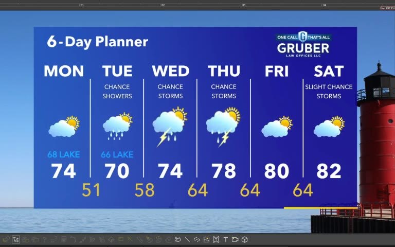
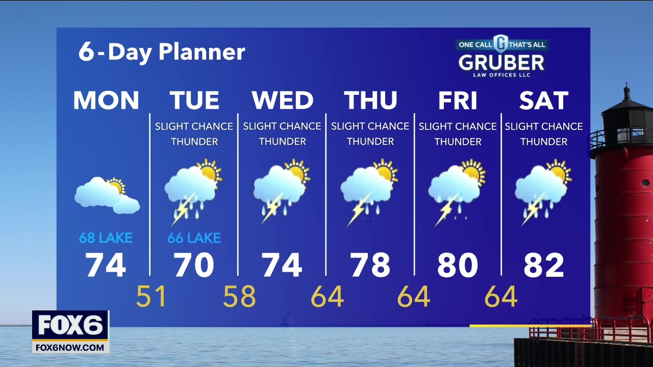
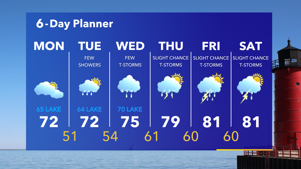
Mostly cloudy on Monday with highs in the 60s near the lake, 70s inland. A big warm up is on the way late in the week with highs in the 80s.
Mostly cloudy on Monday with highs in the 60s near the lake, 70s inland. A big warm up is on the way late in the week with highs in the 80s.