

Forecast from Meteorologist Stephanie Barichello
Another hot and humid day, especially inland, where temperatures will be in the upper 80s and low 90s. Even hotter Friday then at least less humid by the second half of the weekend.
Another hot and humid day, especially inland, where temperatures will be in the upper 80s and low 90s. Even hotter Friday then at least less humid by the second half of the weekend.
Weather webcast with Rob Haswell
Another hot and humid day with highs in the upper 80s to near 90 inland. A southeast wind will keep things cooler near the lake. Dewpoints will once again be in the mid to upper 60s for a very muggy day.
Another hot and humid day with highs in the upper 80s to near 90 inland. A southeast wind will keep things cooler near the lake. Dewpoints will once again be in the mid to upper 60s for a very muggy day.
Weather Webcast with Tom Wachs
Areas of fog return overnight with temperatures in the 60s. Partly sunny on Thursday with temperatures in the upper 70s along the lake, upper 80s to around 90 inland.
Areas of fog return overnight with temperatures in the 60s. Partly sunny on Thursday with temperatures in the upper 70s along the lake, upper 80s to around 90 inland.

Weather Webcast with Tom Wachs
Mostly clear and muggy tonight. Patchy fog developing. Temperatures falling into the 60s. Partly sunny on Thursday with highs in the upper 80s inland, near 80 along the lake.
Mostly clear and muggy tonight. Patchy fog developing. Temperatures falling into the 60s. Partly sunny on Thursday with highs in the upper 80s inland, near 80 along the lake.
Forecast from Meteorologist Stephanie Barichello
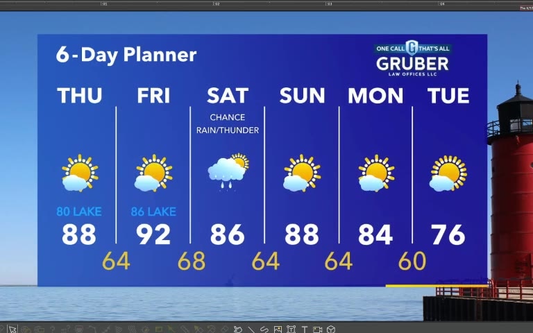
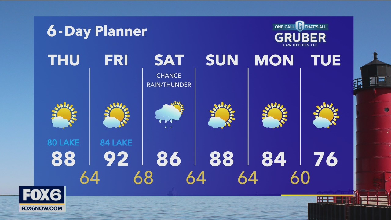
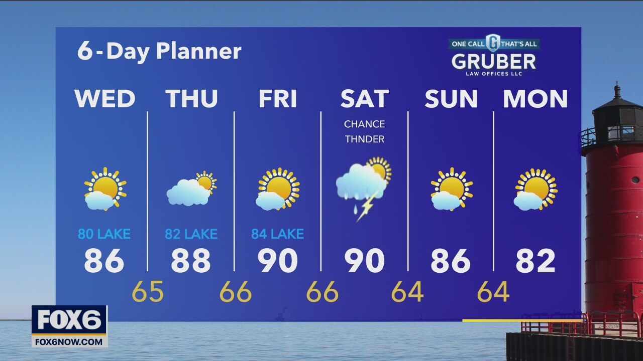
Sunny, warm and humid again today -- coolest temperatures lakeside with a northeast wind. Could see some fog overnight otherwise similar conditions Thursday. Next chance for rain will be Friday night into Saturday.
Sunny, warm and humid again today -- coolest temperatures lakeside with a northeast wind. Could see some fog overnight otherwise similar conditions Thursday. Next chance for rain will be Friday night into Saturday.
Weather webcast with Rob Haswell
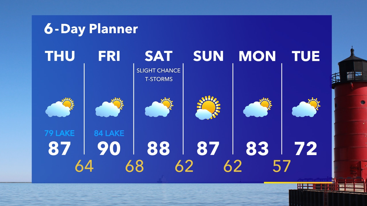
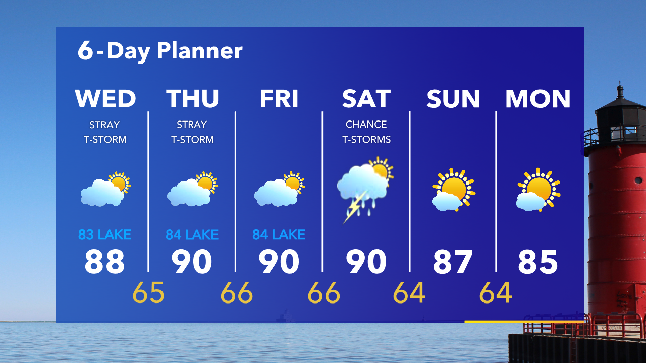
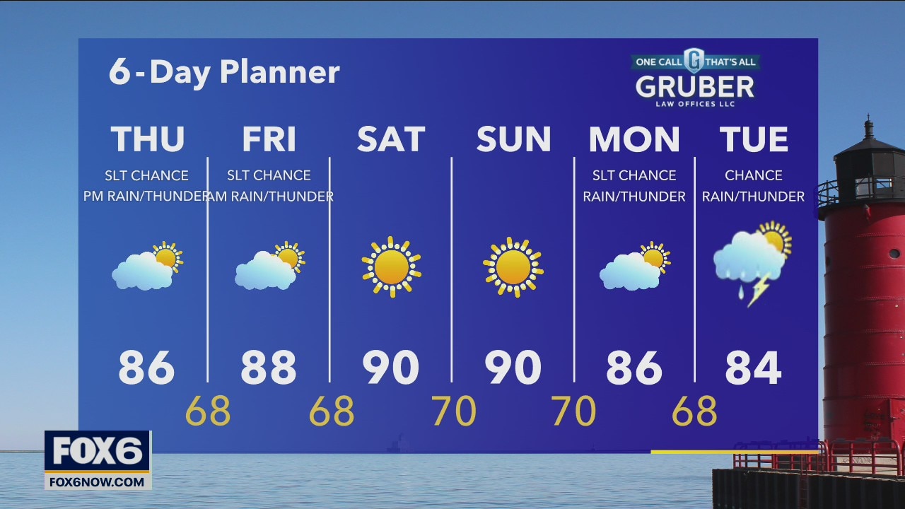
Another hot and humid day today with highs in the mid to upper 80s and dewpoints in the mid to upper 60s. We stay hot tomorrow and Friday with a slight reduction in humidity but still muggy at times. We should stay mostly dry for the next few days although a stray shower or storm cannot be ruled out today or tomorrow.
Another hot and humid day today with highs in the mid to upper 80s and dewpoints in the mid to upper 60s. We stay hot tomorrow and Friday with a slight reduction in humidity but still muggy at times. We should stay mostly dry for the next few days although a stray shower or storm cannot be ruled out today or tomorrow.
Weather Webcast with Tom Wachs
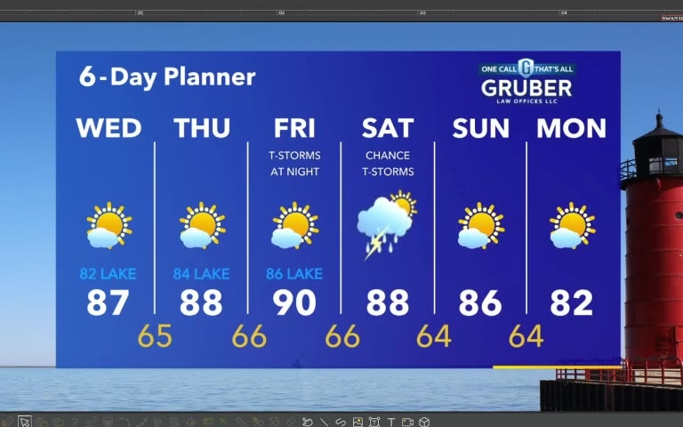
Muggy overnight with temperatures falling into the 60s by sunrise. Another warm and humid day on Wednesday with a very slight chance for a t-storm. Highs in the upper 80s inland, upper 70s to low 80s right along the lake.
Muggy overnight with temperatures falling into the 60s by sunrise. Another warm and humid day on Wednesday with a very slight chance for a t-storm. Highs in the upper 80s inland, upper 70s to low 80s right along the lake.

Weather Webcast with Tom Wachs
Partly cloudy and muggy tonight with temperatures falling into the 60s. Partly sunny, warm and humid on Wednesday. Only a slim chance for a t-storm. Highs in the upper 80s in most area, low 80s closer to the lake.
Partly cloudy and muggy tonight with temperatures falling into the 60s. Partly sunny, warm and humid on Wednesday. Only a slim chance for a t-storm. Highs in the upper 80s in most area, low 80s closer to the lake.
Forecast from Meteorologist Stephanie Barichello
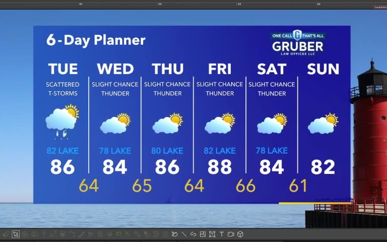
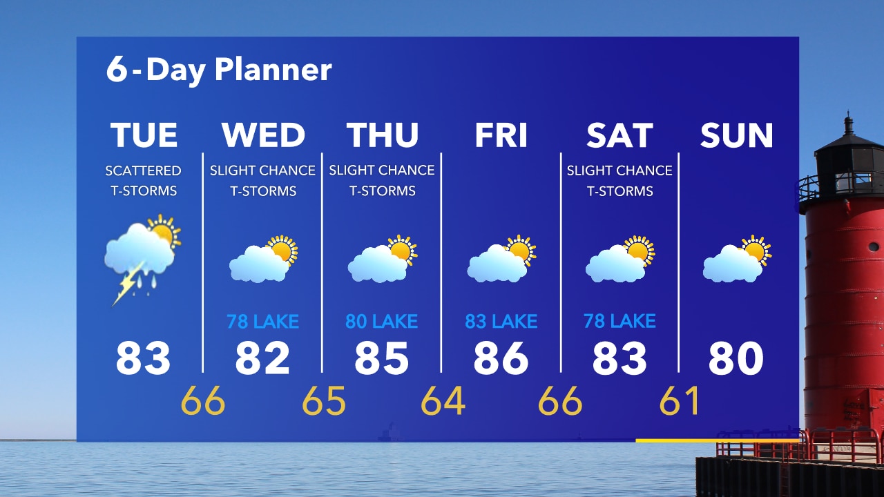
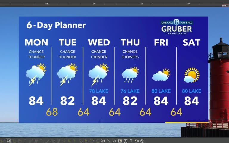
Scattered thunderstorms today, mainly inland. Warm and muggy conditions last the rest of the week.
Scattered thunderstorms today, mainly inland. Warm and muggy conditions last the rest of the week.

Weather Webcast with Tom Wachs
There is a slight chance for a rain shower overnight. Temperatures around 70 by sunrise. Scattered t-storms on Tuesday with a humid high in the lower 80s.
There is a slight chance for a rain shower overnight. Temperatures around 70 by sunrise. Scattered t-storms on Tuesday with a humid high in the lower 80s.
Weather Webcast with Tom Wachs
An isolated shower or t-storm is possible tonight. But the big story is the humidity. It will stay humid over the next few days. Overnight lows around 70 on Tuesday morning. Scattered t-storms morning into early afternoon.
An isolated shower or t-storm is possible tonight. But the big story is the humidity. It will stay humid over the next few days. Overnight lows around 70 on Tuesday morning. Scattered t-storms morning into early afternoon.
Forecast from Meteorologist Stephanie Barichello
Scattered showers and thunderstorms possible this afternoon, plus very humid. Similar conditions the rest of the week.
Scattered showers and thunderstorms possible this afternoon, plus very humid. Similar conditions the rest of the week.

Weather Webcast with Eric Manges
Another hot and sunny day ahead with high temps getting into the low 90s. Partly cloudy skies by Monday and a chance for scattered showers and isolated PM storms.
Another hot and sunny day ahead with high temps getting into the low 90s. Partly cloudy skies by Monday and a chance for scattered showers and isolated PM storms.
Weather Webcast with A.J. Waterman
Heat continues on Sunday, but rain chances are on the rise over the next 3 days...
Heat continues on Sunday, but rain chances are on the rise over the next 3 days...
Weather Webcast with A.J. Waterman
Another hot one on Sunday, but rain chances are increasing over the next few days...
Another hot one on Sunday, but rain chances are increasing over the next few days...
Weather Webcast with Eric Manges
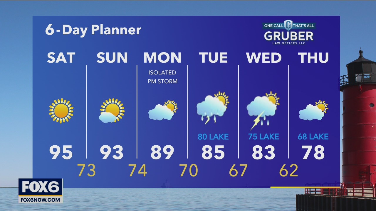
We've got a chance to set record highs this weekend with the potential to reach the mid-90s this afternoon and get close again on Sunday. Monday and Tuesday we slowly get back into the 80s with a chance for isolated storms.
We've got a chance to set record highs this weekend with the potential to reach the mid-90s this afternoon and get close again on Sunday. Monday and Tuesday we slowly get back into the 80s with a chance for isolated storms.

Weather Webcast with A.J. Waterman
Near-record heat continues into the weekend, but storms look to cool things down next week...
Near-record heat continues into the weekend, but storms look to cool things down next week...
Weather Webcast with Stephanie Barichello
A few showers tonight then heating back up Friday into the weekend.
A few showers tonight then heating back up Friday into the weekend.
Weather Webcast with Stephanie Barichello
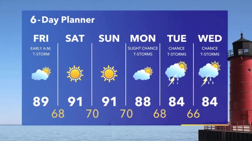
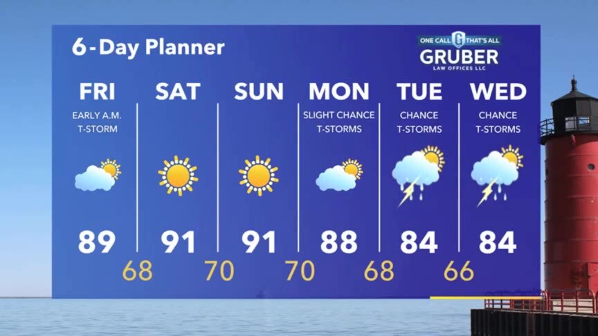
Chance for a few t-storms tonight and early Friday then sunny and hot over the weekend.
Chance for a few t-storms tonight and early Friday then sunny and hot over the weekend.
Weather webcast with Rob Haswell
Another day with ample sunshine and lots of heat as we warm into them mid 80s in most areas. Dewpoints will stay low today but will climb slightly in the days ahead. There may be enough moisture for a few showers or thunderstorms later today, tonight and early Friday morning.
Another day with ample sunshine and lots of heat as we warm into them mid 80s in most areas. Dewpoints will stay low today but will climb slightly in the days ahead. There may be enough moisture for a few showers or thunderstorms later today, tonight and early Friday morning.