

Weather webcast with Rob Haswell
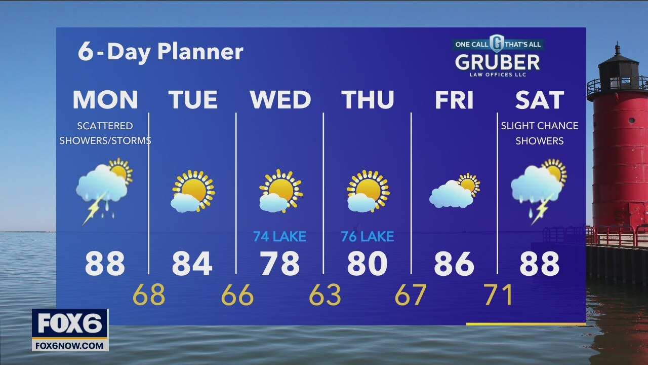
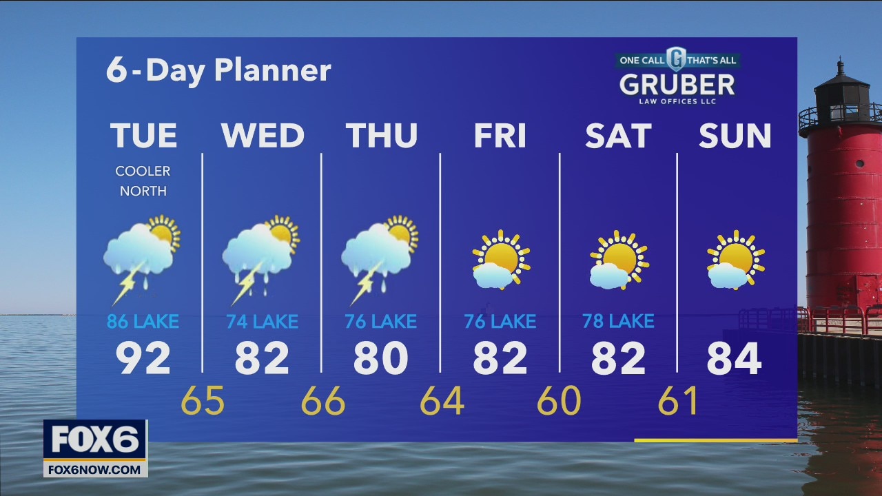
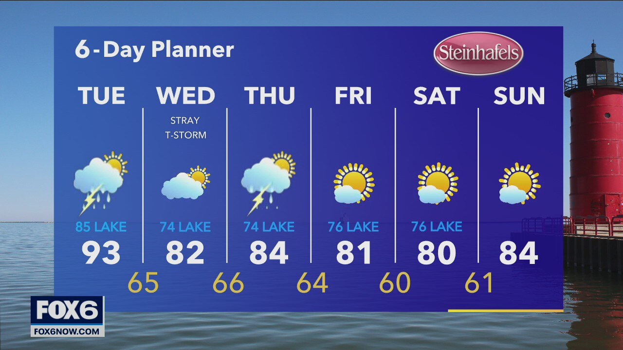
Ahead of a cold front most of the day today we warm into the upper 80s. As the front moves through we can expect scattered showers and thunderstorms. We cool back into the low 80s with far lower dewpoints Tuesday and return to sunshine for most but isolated storms are possible.
Ahead of a cold front most of the day today we warm into the upper 80s. As the front moves through we can expect scattered showers and thunderstorms. We cool back into the low 80s with far lower dewpoints Tuesday and return to sunshine for most but isolated storms are possible.

Weather Webcast with Eric Manges
Most of the day stays fantastic. There's a chance for scattered light rain in the afternoon especially NW. The next widespread rain chance will be throughout Monday PM. Scattered showers and a few storms are possible. Sunshine returns in no time Tuesday with highs staying seasonable.
Most of the day stays fantastic. There's a chance for scattered light rain in the afternoon especially NW. The next widespread rain chance will be throughout Monday PM. Scattered showers and a few storms are possible. Sunshine returns in no time Tuesday with highs staying seasonable.
Weather webcast with Rob Haswell
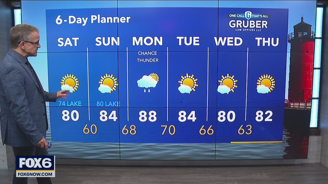
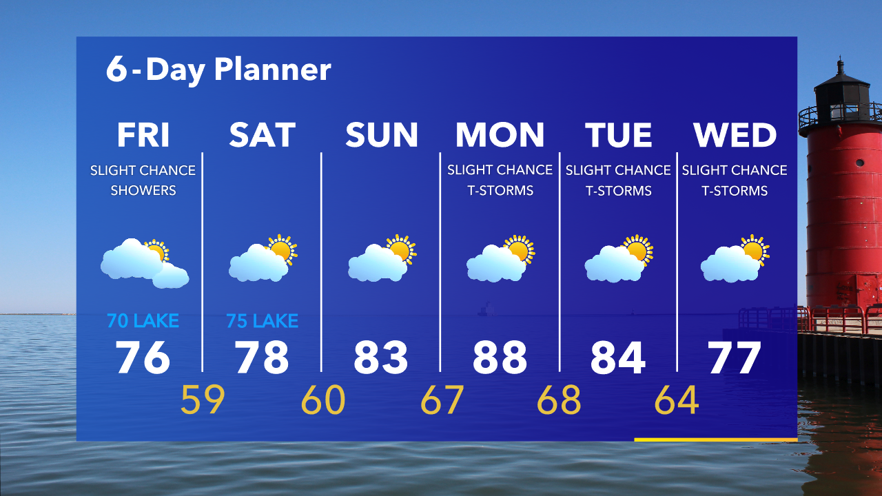
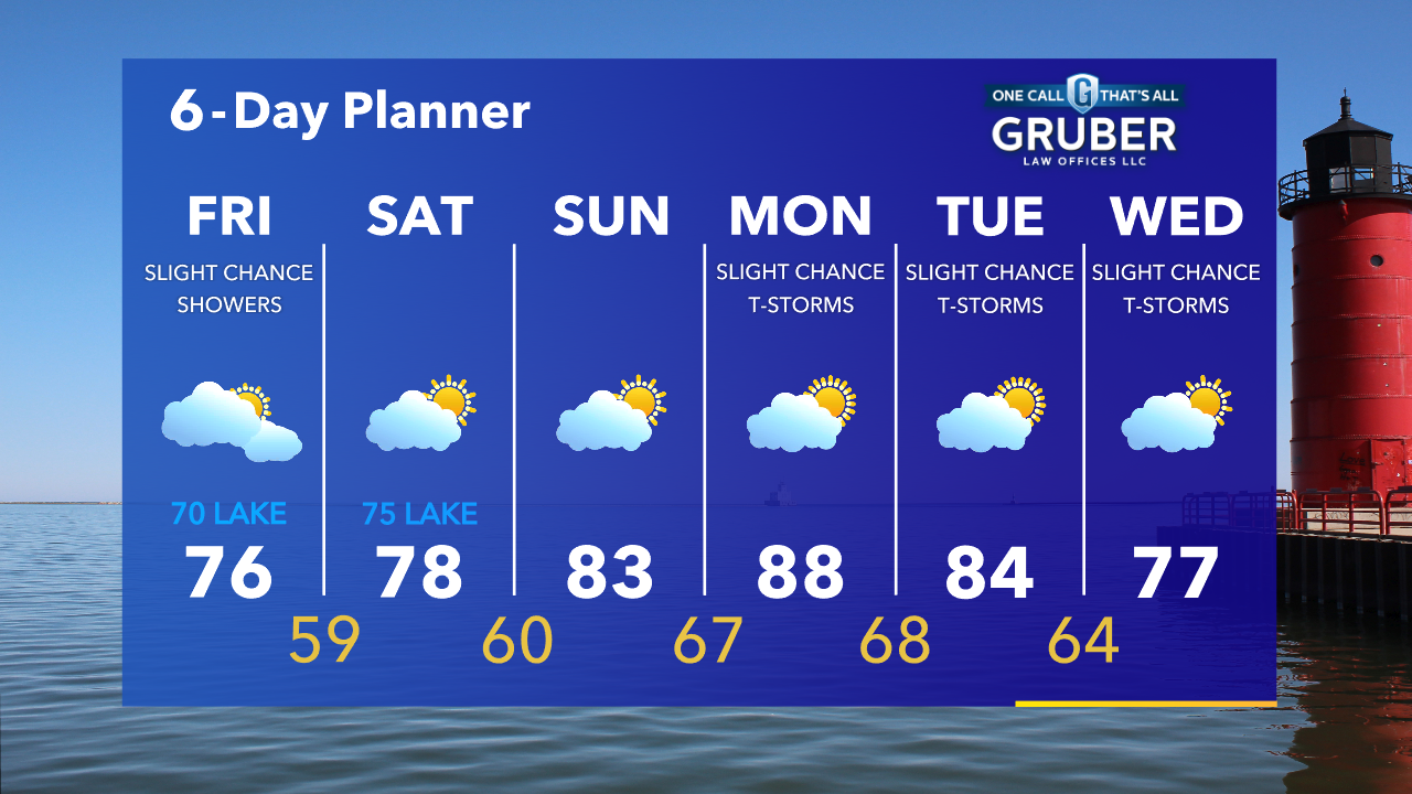
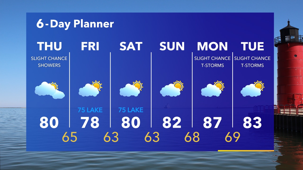
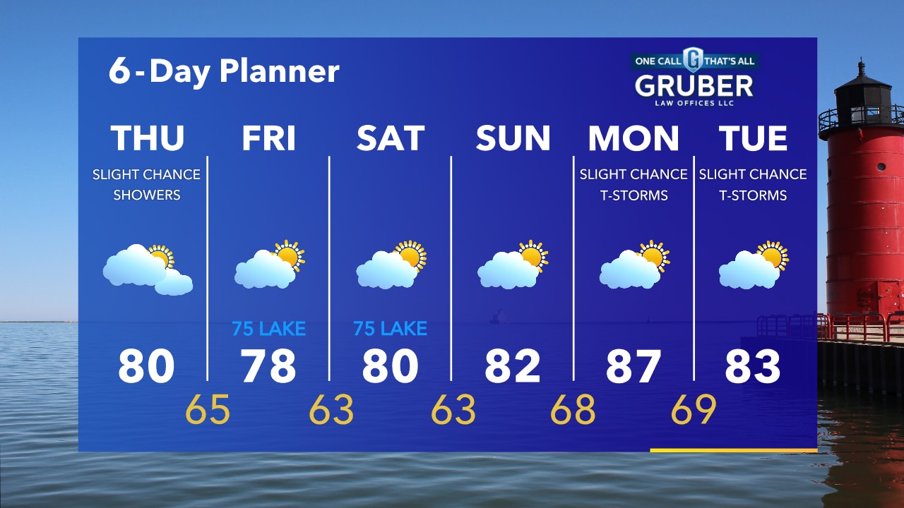
High pressure keeps us clear and dry for a few days with highs today in the seasonal range near 80 inland but mid 70s lakeside. A clear and cooler night with lows in the upper 50s and low 60s tonight. We warm up a little Sunday and more so on Monday with highs going from the mid 80s Sunday to the upper 80s Monday.
High pressure keeps us clear and dry for a few days with highs today in the seasonal range near 80 inland but mid 70s lakeside. A clear and cooler night with lows in the upper 50s and low 60s tonight. We warm up a little Sunday and more so on Monday with highs going from the mid 80s Sunday to the upper 80s Monday.
Weather Webcast with Eric Manges
A few showers and possibly isolated thunderstorms as a cold front passes through our area this afternoon. Highs will be in the mid to upper 70s inland with low 70s lakeside due to a strong NE wind.
A few showers and possibly isolated thunderstorms as a cold front passes through our area this afternoon. Highs will be in the mid to upper 70s inland with low 70s lakeside due to a strong NE wind.
Weather Webcast with Rob Haswell
Some patchy fog this morning then a chance for a few showers and possibly isolated thunderstorms as a cold front passes through our area. Highs will be in the mid to upper 70s inland with low 70s lakeside due to a strong NE wind. That wind will also cause strong waves and dangerous currents.
Some patchy fog this morning then a chance for a few showers and possibly isolated thunderstorms as a cold front passes through our area. Highs will be in the mid to upper 70s inland with low 70s lakeside due to a strong NE wind. That wind will also cause strong waves and dangerous currents.
Weather Webcast with Tom Wachs
Patchy fog overnight especially near the lake. Temperatures in the 60s. Mostly cloudy and breezy on Friday with an isolated rain shower. Highs in the 70s, coolest near the lake.
Patchy fog overnight especially near the lake. Temperatures in the 60s. Mostly cloudy and breezy on Friday with an isolated rain shower. Highs in the 70s, coolest near the lake.
Weather Webcast with Tom Wachs
Fog near the lake tonight, otherwise partly to mostly cloudy. Temperatures falling into the 60s. Slight chance for a rain shower Friday, mostly cloudy and breezy. Highs in the 70s.
Fog near the lake tonight, otherwise partly to mostly cloudy. Temperatures falling into the 60s. Slight chance for a rain shower Friday, mostly cloudy and breezy. Highs in the 70s.
Weather Webcast with Meteorologist Stephanie Barichello
Partly to mostly cloudy today with highs in the 80s, cooler lakeside. A few t-storms possible tonight and early Friday then quiet, cooler over the weekend.
Partly to mostly cloudy today with highs in the 80s, cooler lakeside. A few t-storms possible tonight and early Friday then quiet, cooler over the weekend.
Weather webcast with Rob Haswell
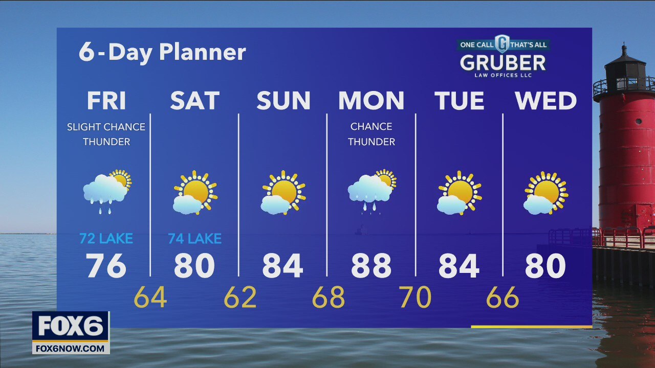
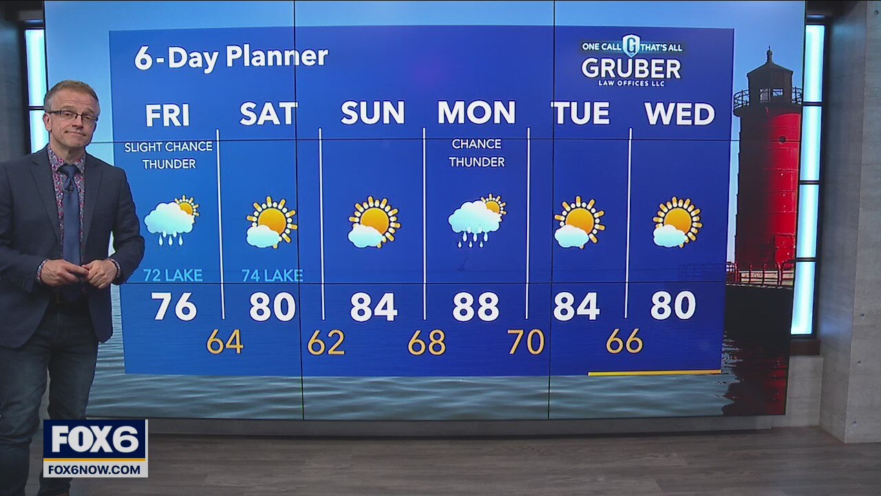
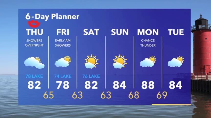
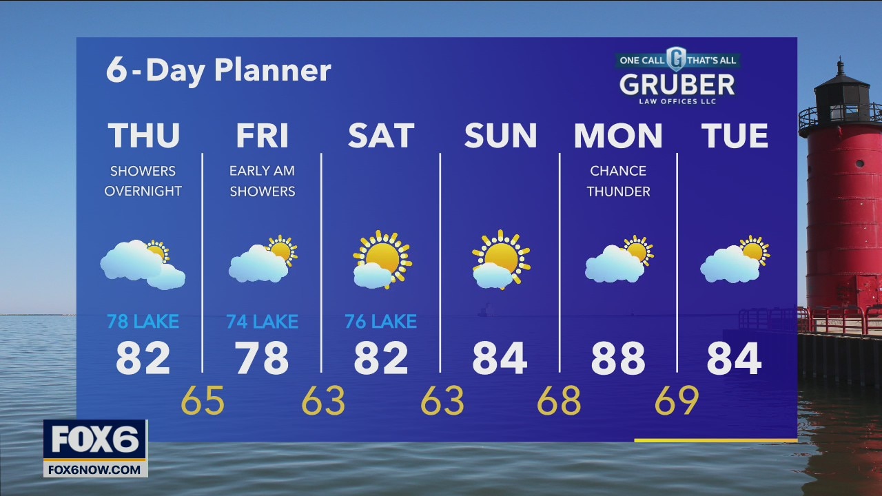
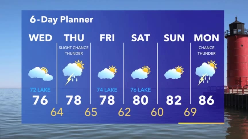
A low passes to our south today and tonight but we should stay mostly dry with just a slight chance for showers overnight and Friday morning. Temperatures warm from yesterday with highs returning to the low 80s and upper 70s lakeside. A bit cooler Friday as we dip back into the 70s before a push of warmer air this weekend. Weekend conditions will be mostly sunny and stay dry.
A low passes to our south today and tonight but we should stay mostly dry with just a slight chance for showers overnight and Friday morning. Temperatures warm from yesterday with highs returning to the low 80s and upper 70s lakeside. A bit cooler Friday as we dip back into the 70s before a push of warmer air this weekend. Weekend conditions will be mostly sunny and stay dry.
Weather Webcast with Tom Wachs
Partly cloudy skies overnight with temperatures in the 60s. Increasing clouds on Thursday with a high around 80. Slight chance for an afternoon rain shower.
Partly cloudy skies overnight with temperatures in the 60s. Increasing clouds on Thursday with a high around 80. Slight chance for an afternoon rain shower.
Weather Webcast with Tom Wachs
Dry tonight under partly cloudy skies. Temperatures falling into the 60s. Only a slight chance for a rain shower Thursday afternoon, otherwise increasing clouds with a high around 80.
Dry tonight under partly cloudy skies. Temperatures falling into the 60s. Only a slight chance for a rain shower Thursday afternoon, otherwise increasing clouds with a high around 80.
Weather Webcast with Meteorologist Stephanie Barichello
Drying out today then another chance for a few t-storms Thursday. Pleasant and sunny over the weekend!
Drying out today then another chance for a few t-storms Thursday. Pleasant and sunny over the weekend!
Weather webcast with Rob Haswell
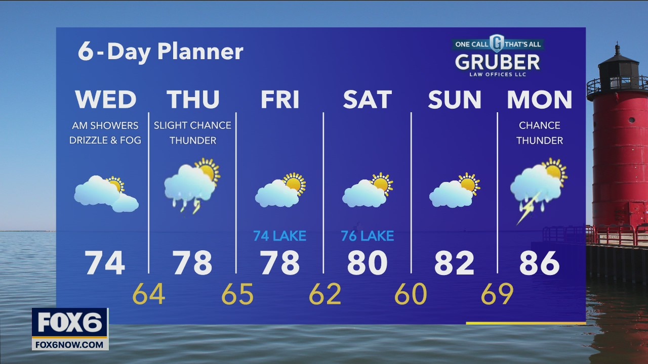
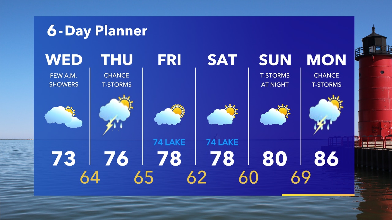
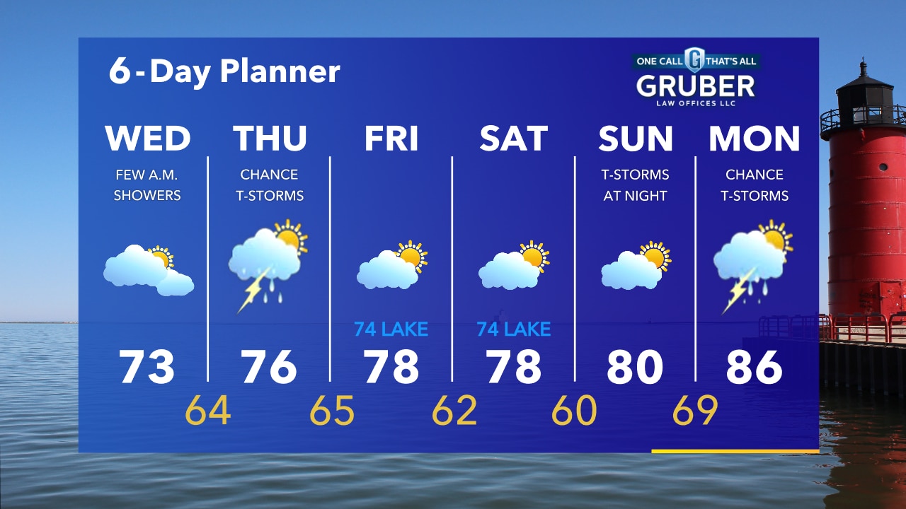
A wet start with some light showers, drizzle and patchy fog then slowly drying up a bit today. Much cooler today with highs in the low to mid 70s. Rain and a slight chance for thunderstorms returns tomorrow but we should dry up by Friday and stay dry through the weekend.
A wet start with some light showers, drizzle and patchy fog then slowly drying up a bit today. Much cooler today with highs in the low to mid 70s. Rain and a slight chance for thunderstorms returns tomorrow but we should dry up by Friday and stay dry through the weekend.
Weather Webcast with Tom Wachs
Showers and t-storms ending overnight. Some fog possible near the lake Wednesday morning as well. Temperatures in the 60s. Humid and cooler on Wednesday with highs in the low 70s, 60s along the lakeshore.
Showers and t-storms ending overnight. Some fog possible near the lake Wednesday morning as well. Temperatures in the 60s. Humid and cooler on Wednesday with highs in the low 70s, 60s along the lakeshore.

Weather Webcast with Tom Wachs
Flash flooding remains a concern in Milwaukee & Waukesha. As storms move out water will gradually recede. Additional storms are possible overnight.
Flash flooding remains a concern in Milwaukee & Waukesha. As storms move out water will gradually recede. Additional storms are possible overnight.
Weather Webcast with Tom Wachs
Strong t-storms are possible tonight mainly southwest of Milwaukee. It will stay humid. Temperatures in the 70s this evening. Fog and light rain possible overnight into Wednesday morning. More humidity on Wednesday with highs in the 70s.
Strong t-storms are possible tonight mainly southwest of Milwaukee. It will stay humid. Temperatures in the 70s this evening. Fog and light rain possible overnight into Wednesday morning. More humidity on Wednesday with highs in the 70s.
Weather Webcast with Stephanie Barichello
Very humid today with temperatures in the 80s and 90s. Where it's in the 90s, expect heat indices in the 100s. There is a chance for thunderstorms again this afternoon and evening, mainly from Jefferson to Milwaukee Co. and southward.
Very humid today with temperatures in the 80s and 90s. Where it's in the 90s, expect heat indices in the 100s. There is a chance for thunderstorms again this afternoon and evening, mainly from Jefferson to Milwaukee Co. and southward.

Weather webcast with Rob Haswell
Another active day today with rain and thunderstorms returning to the area this afternoon. Strong to severe storms are possible again today. Temperatures will vary across the area with highs well into the 90s west and southwest of Milwaukee where there is a Heat Advisory and in the 80s for areas east and north of the metro.
Another active day today with rain and thunderstorms returning to the area this afternoon. Strong to severe storms are possible again today. Temperatures will vary across the area with highs well into the 90s west and southwest of Milwaukee where there is a Heat Advisory and in the 80s for areas east and north of the metro.
Weather Webcast with A.J. Waterman
Scattered storms moving through the area, with strong winds and small to medium-size hail possible.
Scattered storms moving through the area, with strong winds and small to medium-size hail possible.
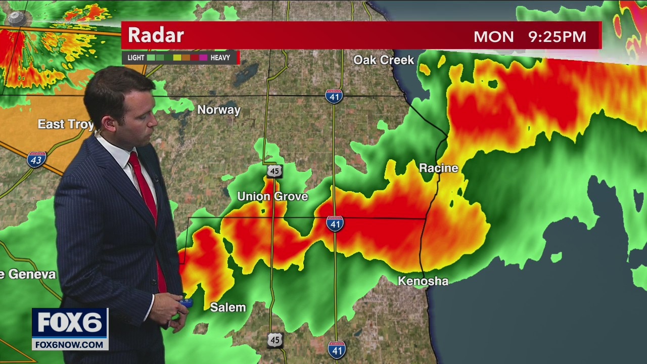
Weather Webcast with A.J. Waterman
Tracking strong to severe storms across SE Wisconsin...
Tracking strong to severe storms across SE Wisconsin...