

Weather Webcast with Eric Manges
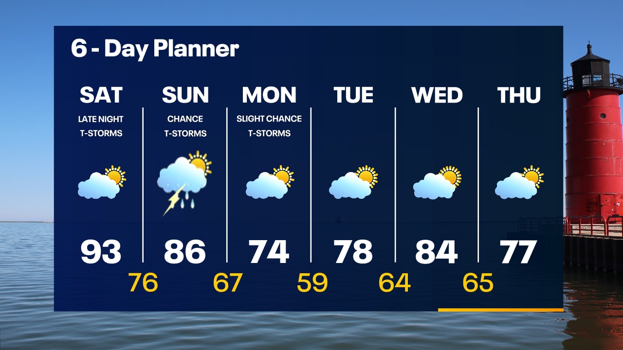
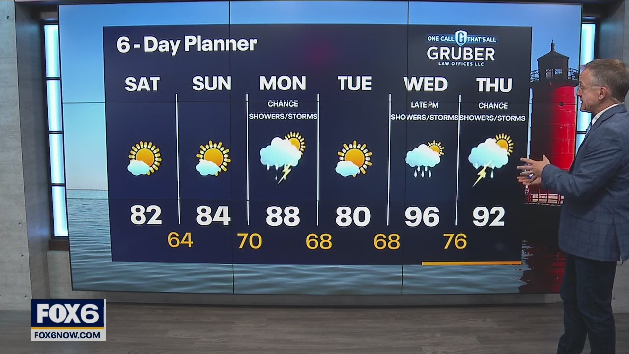
Partly cloudy and very humid today. Heat index values approach the upper 90s this afternoon, stay cool. Scattered showers and storms move in overnight and continue Sunday into Monday morning. Heavy rain main concern.
Partly cloudy and very humid today. Heat index values approach the upper 90s this afternoon, stay cool. Scattered showers and storms move in overnight and continue Sunday into Monday morning. Heavy rain main concern.
Weather Webcast with Tom Wachs
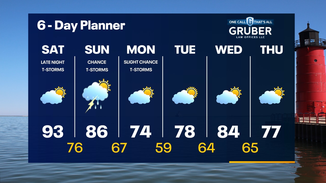
Humid overnight with temperatures in the 70s. Hot and humid on Saturday with highs in the low 90s and a heat index around 102. T-Storms move in late Saturday night.
Humid overnight with temperatures in the 70s. Hot and humid on Saturday with highs in the low 90s and a heat index around 102. T-Storms move in late Saturday night.
Weather Webcast with Tom Wachs
Humid tonight with temperatures dropping into the 70s. Partly sunny, hot and humid on Saturday with highs in the 90s and a heat index around 102.
Humid tonight with temperatures dropping into the 70s. Partly sunny, hot and humid on Saturday with highs in the 90s and a heat index around 102.
Weather webcast with Rob Haswell
High pressure retreats to the east today but keeps us sunny and calm today with comfortable highs in the mid 80s. We will be closer to 80 near the lake with a breeze off the water all day. A low moves in this weekend. Ahead of that low most of Saturday we warm into the upper 80s and low 90s with very high dewpoints. As the system moves through we can expect rain and thunderstorms into Sunday.
High pressure retreats to the east today but keeps us sunny and calm today with comfortable highs in the mid 80s. We will be closer to 80 near the lake with a breeze off the water all day. A low moves in this weekend. Ahead of that low most of Saturday we warm into the upper 80s and low 90s with very high dewpoints. As the system moves through we can expect rain and thunderstorms into Sunday.

Weather Webcast with Tom Wachs
Clear and comfortable overnight with temperatures in the 50s to low 60s by sunrise. Mostly sunny with highs in the mid-to-upper 80s inland on Friday, upper 70s along the lake.
Clear and comfortable overnight with temperatures in the 50s to low 60s by sunrise. Mostly sunny with highs in the mid-to-upper 80s inland on Friday, upper 70s along the lake.
Weather Webcast with Tom Wachs
Beautiful this evening with temperatures falling into the 60s under clear skies. A few upper 50s possible away from the lake overnight. More sun on Friday with highs in the 80s inland, 70s near the lake.
Beautiful this evening with temperatures falling into the 60s under clear skies. A few upper 50s possible away from the lake overnight. More sun on Friday with highs in the 80s inland, 70s near the lake.


Weather webcast with Eric Manges
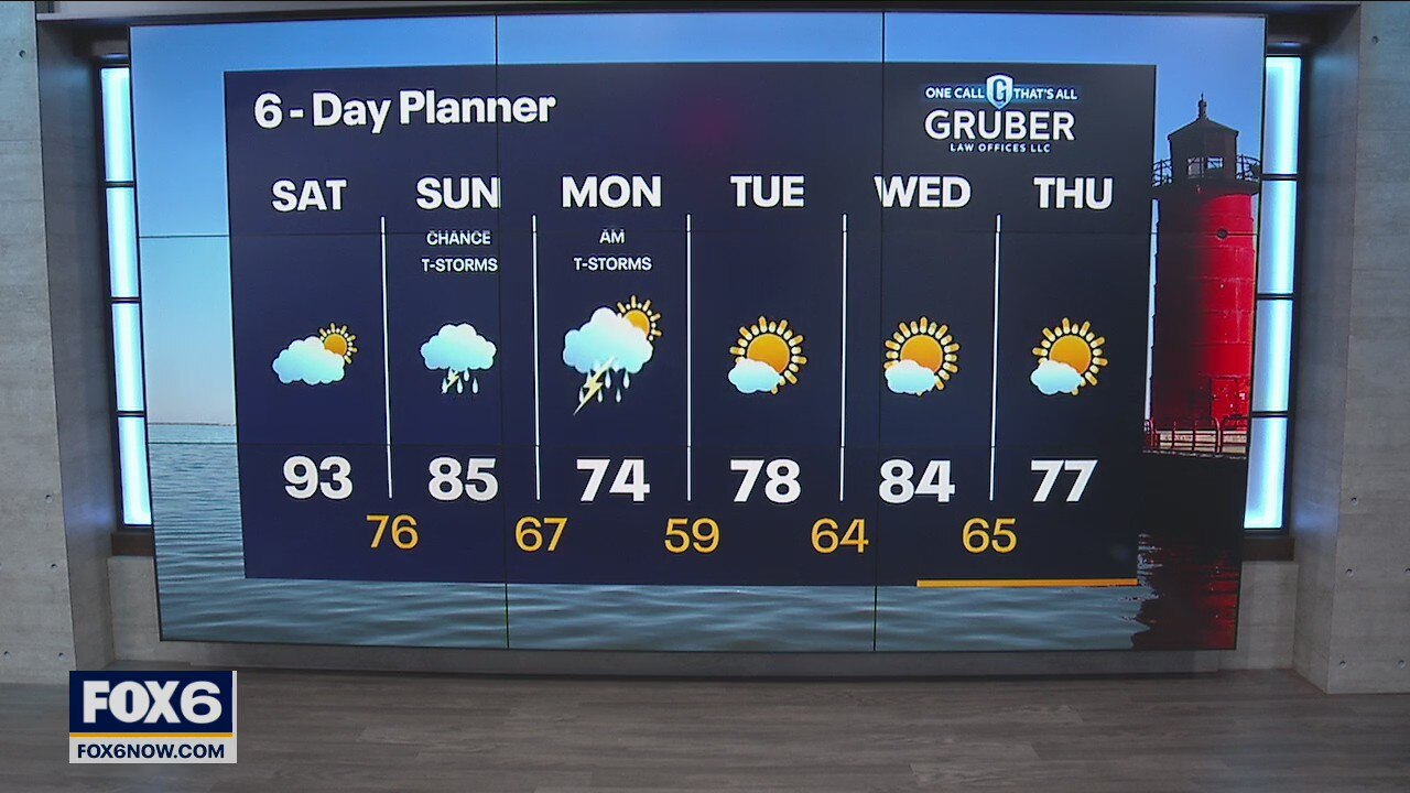
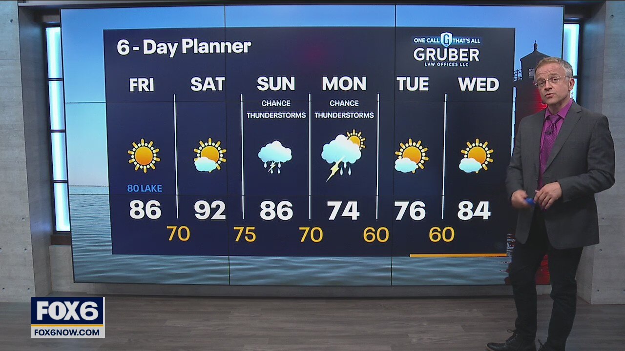
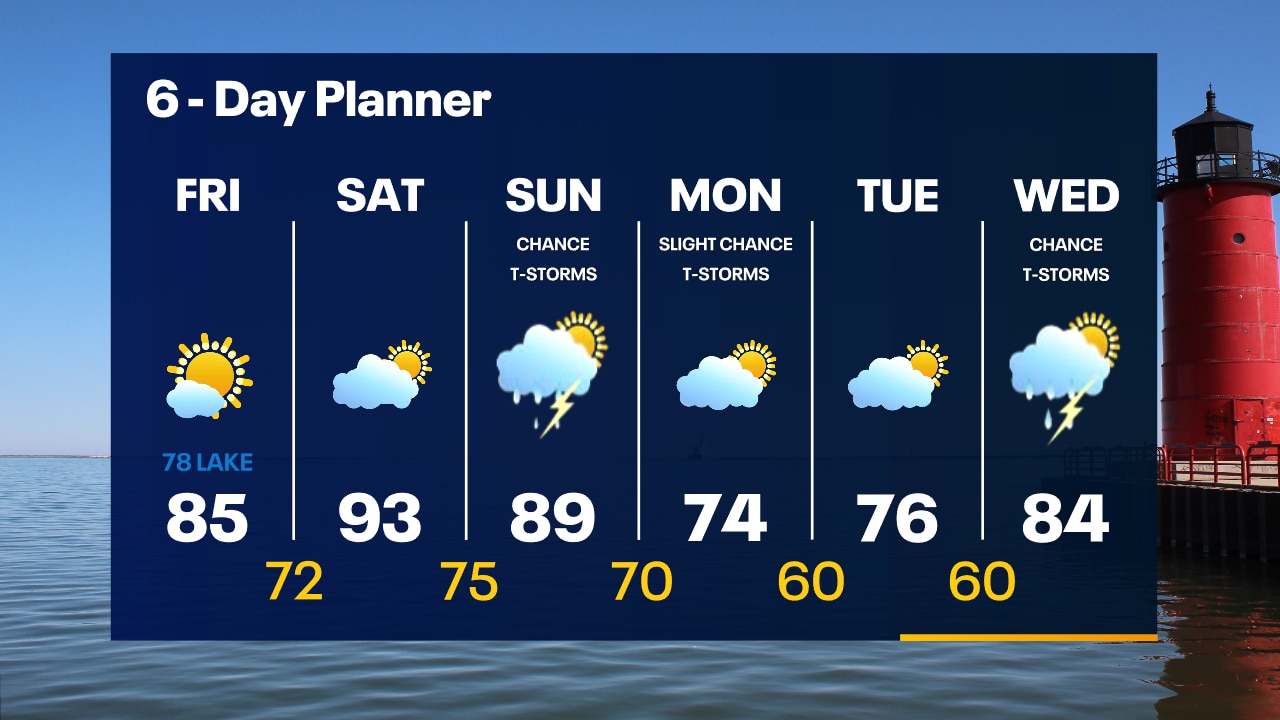
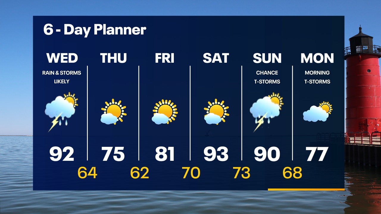
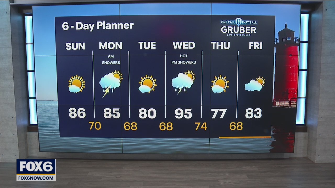
Mostly sunny and beautiful as we stay comfortable for the first day of the State Fair. Skies stay sunny into the start of the weekend with Saturday temps returning into the 90s. Our next chance of rain starts Sunday and continues through Monday morning.
Mostly sunny and beautiful as we stay comfortable for the first day of the State Fair. Skies stay sunny into the start of the weekend with Saturday temps returning into the 90s. Our next chance of rain starts Sunday and continues through Monday morning.
Weather Webcast with Tom Wachs
Mostly clear overnight with humidity levels slowly dropping. Temperatures in the 60s by morning. Abundant sunshine on Thursday with highs in the 70s.
Mostly clear overnight with humidity levels slowly dropping. Temperatures in the 60s by morning. Abundant sunshine on Thursday with highs in the 70s.
Weather Webcast with Tom Wachs
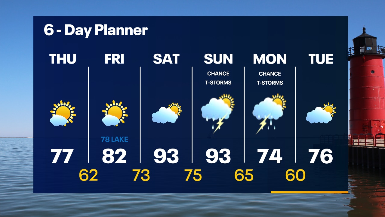
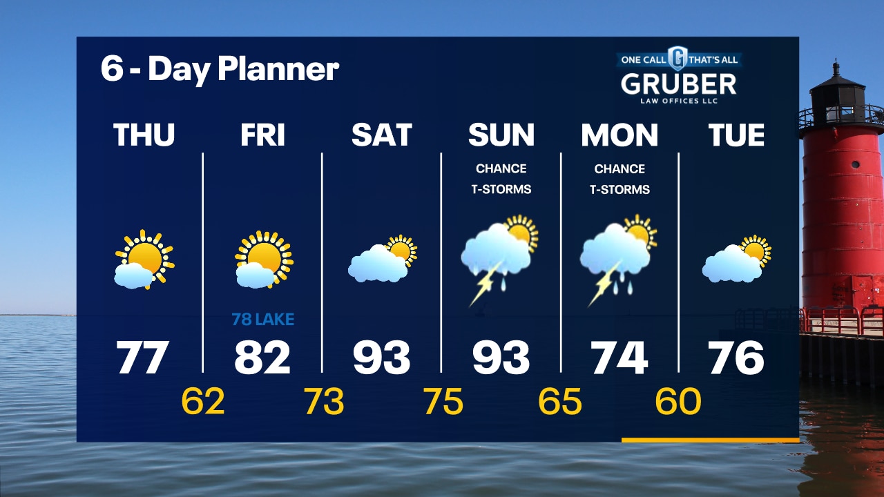
Slight chance for a t-storm this evening otherwise skies clearing out. Temperatures in the 70s. Sunny and beautiful for the opening of State Fair on Thursday with highs in the 70s.
Slight chance for a t-storm this evening otherwise skies clearing out. Temperatures in the 70s. Sunny and beautiful for the opening of State Fair on Thursday with highs in the 70s.
Weather webcast with Rob Haswell
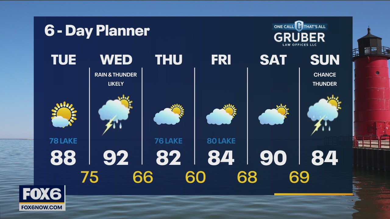
A warm front moving through today brings more heat and humidity and a chance for rain and thunderstorms. Highs will reach the low 90s with dewpoints in the 70s but fall behind the cold front arriving later today and tonight. High pressure will calm our area Thursday through Saturday.
A warm front moving through today brings more heat and humidity and a chance for rain and thunderstorms. Highs will reach the low 90s with dewpoints in the 70s but fall behind the cold front arriving later today and tonight. High pressure will calm our area Thursday through Saturday.
Weather Webcast with Tom Wachs
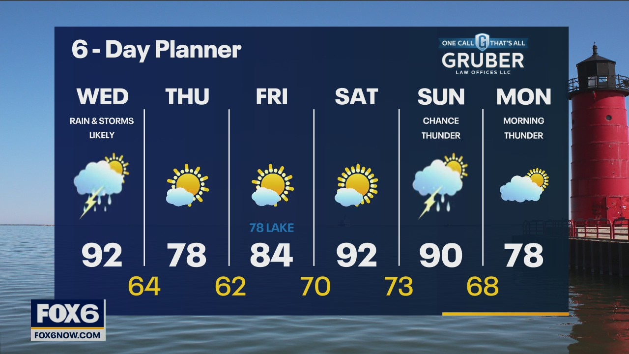
Slight chance for a t-storm toward sunrise otherwise muggy overnight. Temperatures in the 70s. Hot and humid on Wednesday with highs in the low 90s. Thunderstorms move in late in the morning into the afternoon.
Slight chance for a t-storm toward sunrise otherwise muggy overnight. Temperatures in the 70s. Hot and humid on Wednesday with highs in the low 90s. Thunderstorms move in late in the morning into the afternoon.

Weather Webcast with Tom Wachs
Mostly clear and humid tonight with temperatures holding in the 70s. Increasing clouds on Wednesday with a hot midday temperature in the 90s. T-Storms move in by late morning/early afternoon.
Mostly clear and humid tonight with temperatures holding in the 70s. Increasing clouds on Wednesday with a hot midday temperature in the 90s. T-Storms move in by late morning/early afternoon.
Weather webcast with Rob Haswell
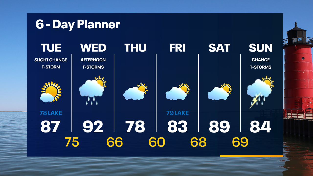
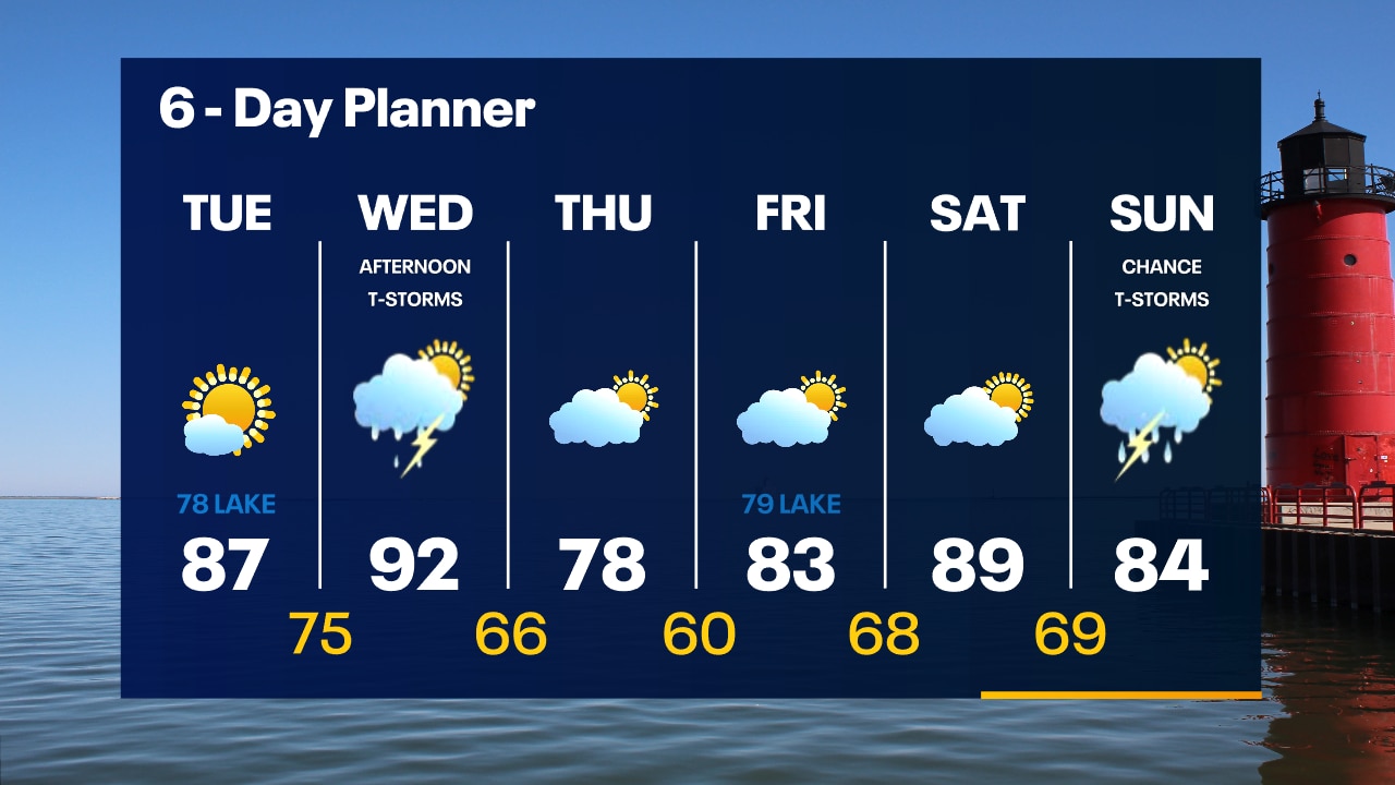
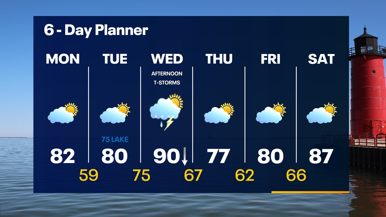
High pressure over our area keeps things calm and dry today with highs in the upper 80s inlance but a breezy SE wind will keep it in the upper 70s and low 80s near the lake. A strong warm front arrives tomorrow pushing highs into the low 90s and dewpoints in the 70s! This comes along with a chance for rain and thunderstorms and a much stronger SW wind.
High pressure over our area keeps things calm and dry today with highs in the upper 80s inlance but a breezy SE wind will keep it in the upper 70s and low 80s near the lake. A strong warm front arrives tomorrow pushing highs into the low 90s and dewpoints in the 70s! This comes along with a chance for rain and thunderstorms and a much stronger SW wind.
Weather Webcast with Tom Wachs
Clear skies overnight with temperatures around 60 by sunrise. Mostly sunny on Tuesday. Highs in the upper 80s inland, upper 70s near the lake. There is a slight chance for an afternoon t-storm.
Clear skies overnight with temperatures around 60 by sunrise. Mostly sunny on Tuesday. Highs in the upper 80s inland, upper 70s near the lake. There is a slight chance for an afternoon t-storm.
Weather Webcast with Tom Wachs
Quiet tonight with mostly clear skies. Temperatures dropping through the 70s this evening and into the 60s overnight. Mostly sunny on Tuesday with highs in the 80s inland, 70s near the lake.
Quiet tonight with mostly clear skies. Temperatures dropping through the 70s this evening and into the 60s overnight. Mostly sunny on Tuesday with highs in the 80s inland, 70s near the lake.
Weather webcast with Rob Haswell
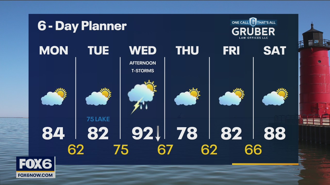
A low moves farther to the east as high pressure builds in from the west with more sunshine for the afternoon. Highs today will be in the low to mid 80s. We cool to the low 60s overnight with just a few clouds. We stay dry with some sun Tuesday then rain and thunderstorms arrive on Wednesday.
A low moves farther to the east as high pressure builds in from the west with more sunshine for the afternoon. Highs today will be in the low to mid 80s. We cool to the low 60s overnight with just a few clouds. We stay dry with some sun Tuesday then rain and thunderstorms arrive on Wednesday.
Weather Webcast with Tom Wachs
A few t-storms are possible overnight with temperatures in the 70s. Partly sunny, breezy and humid on Monday with a high in the low 80s.
A few t-storms are possible overnight with temperatures in the 70s. Partly sunny, breezy and humid on Monday with a high in the low 80s.

Weather Webcast with Tom Wachs
A few t-storms are possible overnight with temperatures in the 70s. Partly sunny, breezy and humid on Monday with highs in the low 80s.
A few t-storms are possible overnight with temperatures in the 70s. Partly sunny, breezy and humid on Monday with highs in the low 80s.
Weather Webcast with Eric Manges
Mostly sunny and nice once again today with highs slightly warmer in the mid-80s. A chance of showers and storms early Monday morning as a weak cold front swings through.
Mostly sunny and nice once again today with highs slightly warmer in the mid-80s. A chance of showers and storms early Monday morning as a weak cold front swings through.
Weather Webcast with Rob Haswell
Seasonable weather over the weekend, heat and storms return next week.
Seasonable weather over the weekend, heat and storms return next week.