

Weather Webcast with Meteorologist Stephanie Barichello
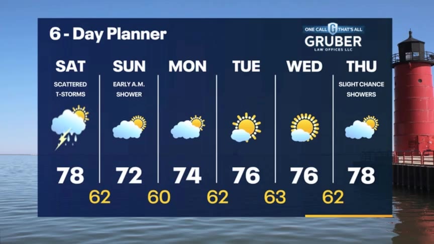
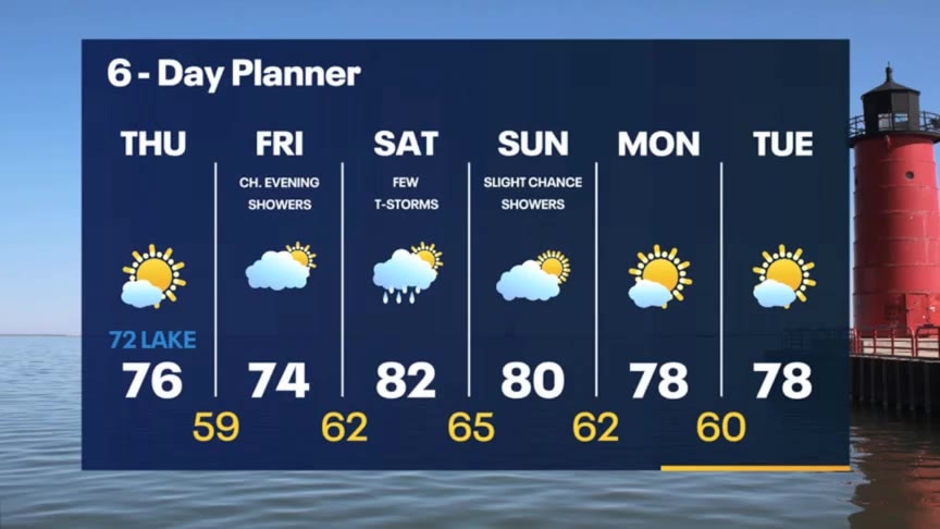
A few sprinkles possible this evening then a better chance for rain and thunder overnight into Saturday morning. Could have a few more scattered showers or storms later Saturday, as well then drying out Sunday.
A few sprinkles possible this evening then a better chance for rain and thunder overnight into Saturday morning. Could have a few more scattered showers or storms later Saturday, as well then drying out Sunday.
Weather webcast with Rob Haswell
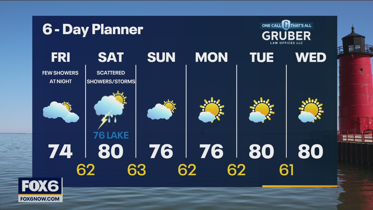
High pressure over our area slowly shifts to the east today as a low moves in bringing more clouds and a slight chance for showers later today and into parts of the weekend. Highs today will be on the cooler side with low to mid 70s likely. We do warm a bit tomorrow as we get to near 80 but we will stay cooler near the lake.
High pressure over our area slowly shifts to the east today as a low moves in bringing more clouds and a slight chance for showers later today and into parts of the weekend. Highs today will be on the cooler side with low to mid 70s likely. We do warm a bit tomorrow as we get to near 80 but we will stay cooler near the lake.
Weather Webcast with Tom Wachs
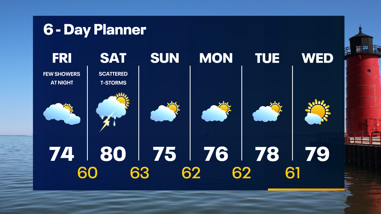
Mostly clear overnight with temperatures falling into the 50s. Increasing clouds on Friday with a high in the middle 70s. A few rain showers are possible Friday night.
Mostly clear overnight with temperatures falling into the 50s. Increasing clouds on Friday with a high in the middle 70s. A few rain showers are possible Friday night.
Weather Webcast with Tom Wachs
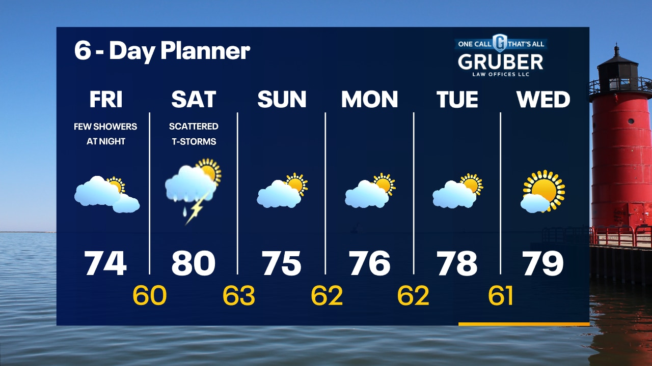
Mostly clear tonight with temperatures falling through the 60s this evening and into the 50s overnight. Increasing clouds on Friday with highs in the 70s. A few rain showers are possible Friday night.
Mostly clear tonight with temperatures falling through the 60s this evening and into the 50s overnight. Increasing clouds on Friday with highs in the 70s. A few rain showers are possible Friday night.
Weather Webcast with Meteorologist Stephanie Barichello
Plenty of sunshine today then a chance for showers Friday evening. Could have a few more passing showers Saturday but it will not be a washout.
Plenty of sunshine today then a chance for showers Friday evening. Could have a few more passing showers Saturday but it will not be a washout.
Weather Webcast with Rob Haswell
High pressure builds in behind yesterday's cold front ushering in cooler and less humid air today. Highs will be in the mid to upper 70s inland today but remain in the lower 70s lakeside with a NE wind throughout the day.
High pressure builds in behind yesterday's cold front ushering in cooler and less humid air today. Highs will be in the mid to upper 70s inland today but remain in the lower 70s lakeside with a NE wind throughout the day.
Weather Webcast with Tom Wachs
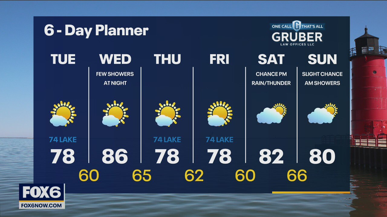
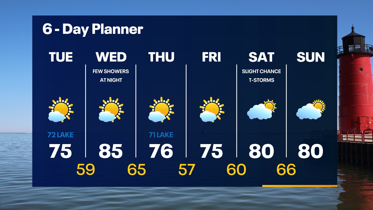
A cold front will move through overnight with a stray t-storm possible. Temperatures will drop into the 60s. Mostly sunny, cooler and less humid on Thursday with highs in the 70s.
A cold front will move through overnight with a stray t-storm possible. Temperatures will drop into the 60s. Mostly sunny, cooler and less humid on Thursday with highs in the 70s.
Weather Webcast with Tom Wachs
A widely scattered shower or t-storm is possible this evening as a cold front moves in from the north. Temperatures dropping into the 70s and eventually the 60s overnight.
A widely scattered shower or t-storm is possible this evening as a cold front moves in from the north. Temperatures dropping into the 70s and eventually the 60s overnight.
Weather Webcast with Meteorologist Stephanie Barichello
A few showers possible tonight then more sunshine to end the week. Slight chances for storms over the weekend.
A few showers possible tonight then more sunshine to end the week. Slight chances for storms over the weekend.
Weather webcast with Rob Haswell
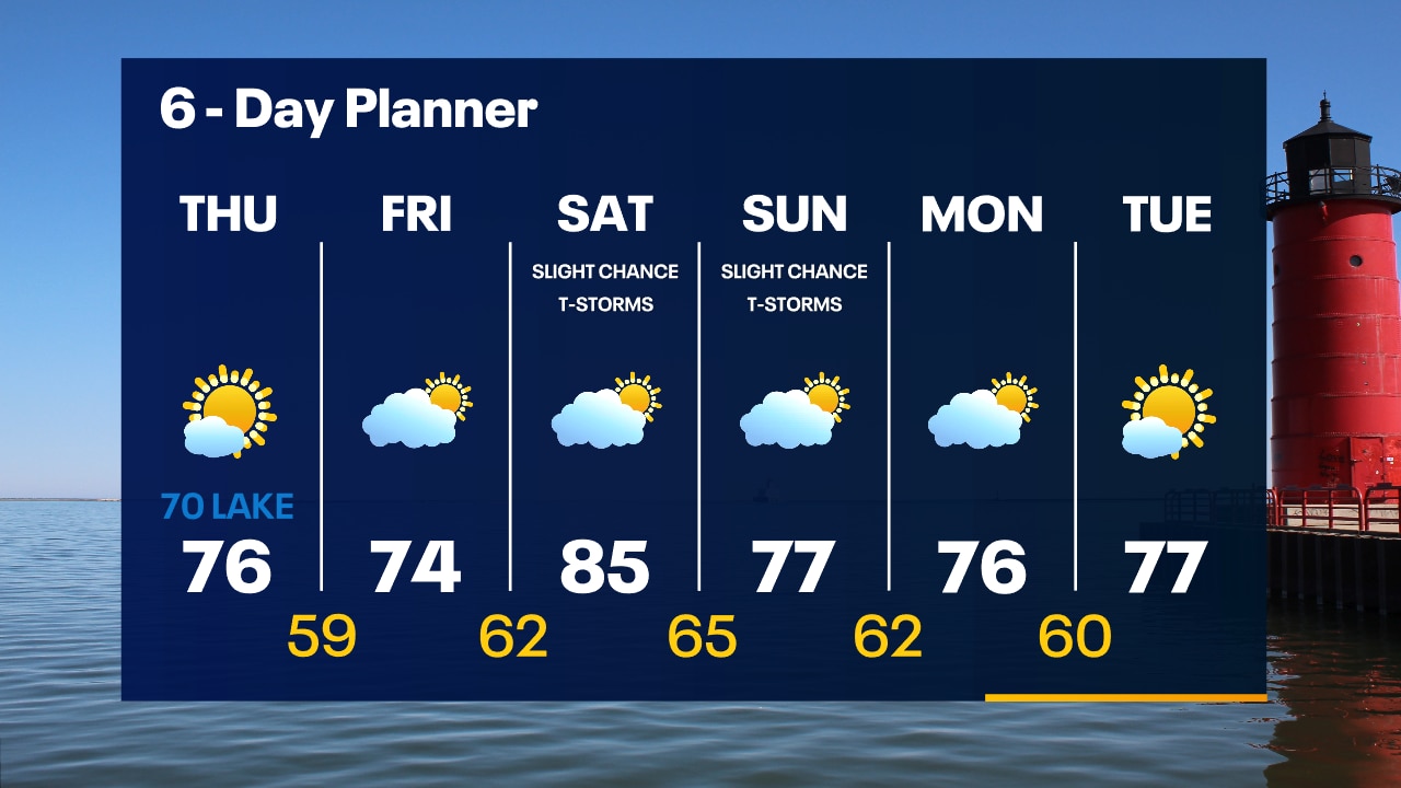
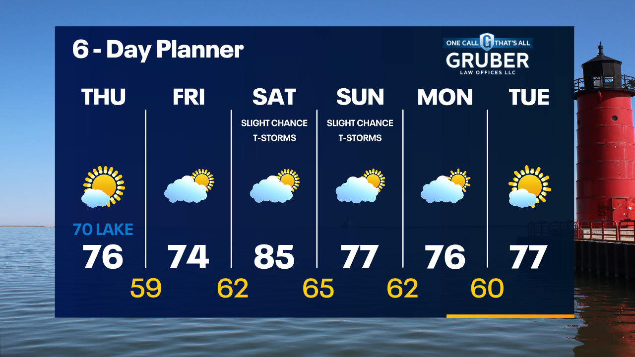
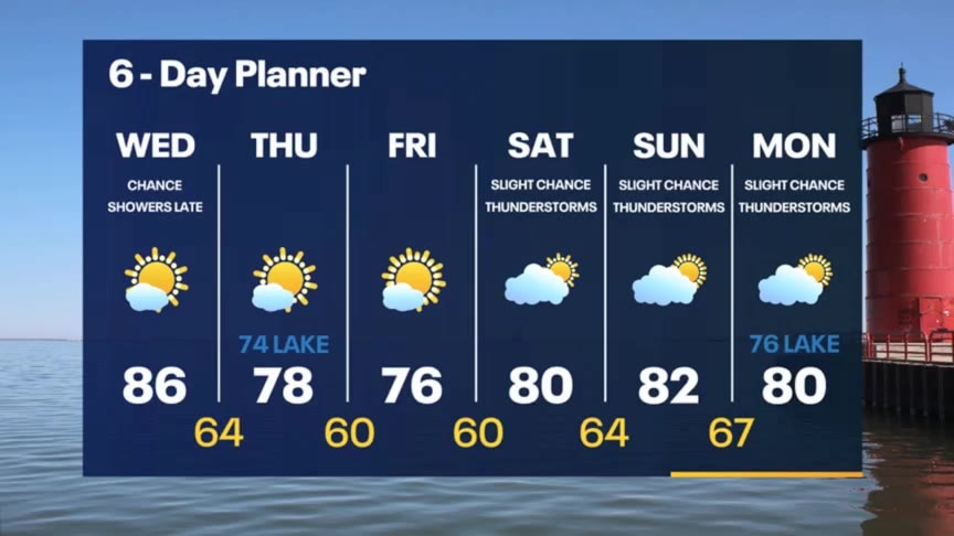
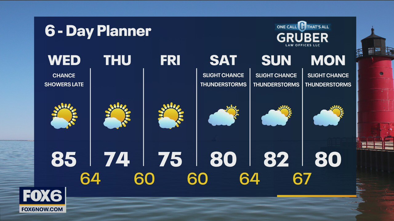
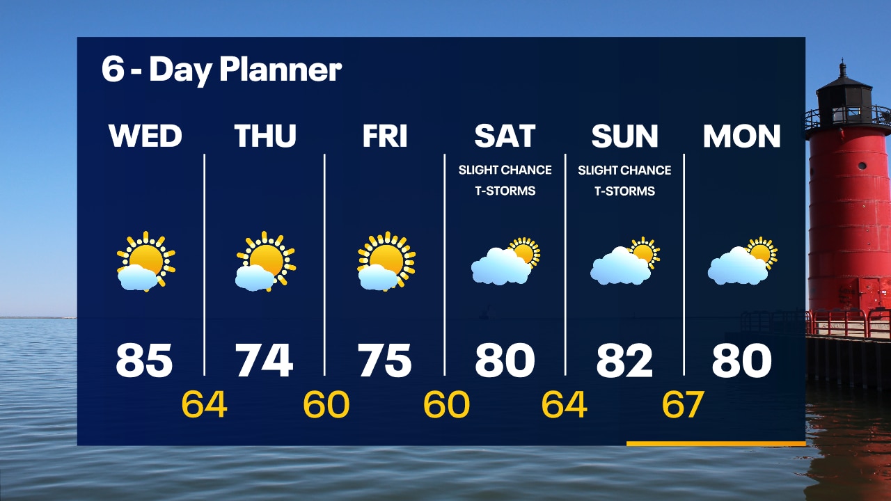
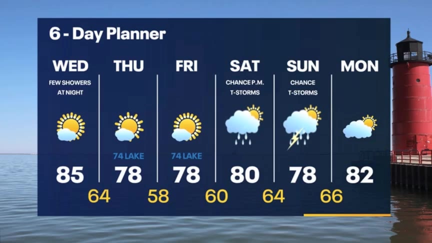
Ahead of a cold front today we warm up with highs in the mid to upper 80s and higher dewpoints for a more humid feel. As the front passes we may see a few showers later this evening and overnight. Highs fall to the 70s behind the passing front. A dry and pleasant day on Friday but a chance for showers returns for the weekend with seasonal highs and slightly higher dewpoints.
Ahead of a cold front today we warm up with highs in the mid to upper 80s and higher dewpoints for a more humid feel. As the front passes we may see a few showers later this evening and overnight. Highs fall to the 70s behind the passing front. A dry and pleasant day on Friday but a chance for showers returns for the weekend with seasonal highs and slightly higher dewpoints.
Weather Webcast with Tom Wachs
Clear and comfortable overnight with temperatures falling into the 50s by sunrise. More sun on Wednesday with a high in the mid-80s and higher humidity levels.
Clear and comfortable overnight with temperatures falling into the 50s by sunrise. More sun on Wednesday with a high in the mid-80s and higher humidity levels.

Weather Webcast with Tom Wachs
Clear and comfortable tonight with temperatures falling through the 60s and into the 50s overnight. More sun on the way Wednesday with a warmer and more humid high in the 80s.
Clear and comfortable tonight with temperatures falling through the 60s and into the 50s overnight. More sun on the way Wednesday with a warmer and more humid high in the 80s.
Weather Webcast with Meteorologist Stephanie Barichello
Clear an cool tonight then heating up briefly Wednesday. Other than a few evening showers Wednesday the rest of the week looks great! Few storms possible over the weekend.
Clear an cool tonight then heating up briefly Wednesday. Other than a few evening showers Wednesday the rest of the week looks great! Few storms possible over the weekend.
Weather webcast with Rob Haswell
A bit of fog this morning that could be dense in a few areas. High pressure keeps us clear and calm for a few days. Highs will reach the mid to upper 70s inland but will be several degrees cooler near the lake. Sunny and a bit warmer tomorrow as winds shift to the West. A weak cold front might trigger a few showers overnight into early Thursday morning and will drop temperatures slightly.
A bit of fog this morning that could be dense in a few areas. High pressure keeps us clear and calm for a few days. Highs will reach the mid to upper 70s inland but will be several degrees cooler near the lake. Sunny and a bit warmer tomorrow as winds shift to the West. A weak cold front might trigger a few showers overnight into early Thursday morning and will drop temperatures slightly.

Weather Webcast with Tom Wachs
Clear skies overnight with patchy fog possible. Temperatures dropping into the 50s. Mostly sunny on Tuesday with highs in the 70s.
Clear skies overnight with patchy fog possible. Temperatures dropping into the 50s. Mostly sunny on Tuesday with highs in the 70s.
Weather Webcast with Tom Wachs
Clearing skies tonight with dropping humidity levels. Temperatures will drop into the 50s overnight. Abundant sunshine on Tuesday with highs in the low-to-mid 70s.
Clearing skies tonight with dropping humidity levels. Temperatures will drop into the 50s overnight. Abundant sunshine on Tuesday with highs in the low-to-mid 70s.
Weather webcast with Rob Haswell
Flood Watch for all of SE WI until 1 p.m. today. Morning rain and thunderstorms with the potential of heavy rain at times as a low and it's associated cold front pass through our area. Dense fog is possible in some areas this morning as well.
Flood Watch for all of SE WI until 1 p.m. today. Morning rain and thunderstorms with the potential of heavy rain at times as a low and it's associated cold front pass through our area. Dense fog is possible in some areas this morning as well.
Weather Webcast with Tom Wachs
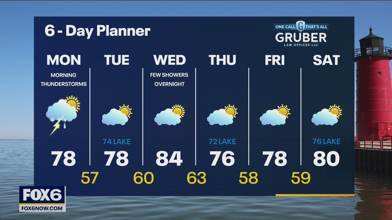
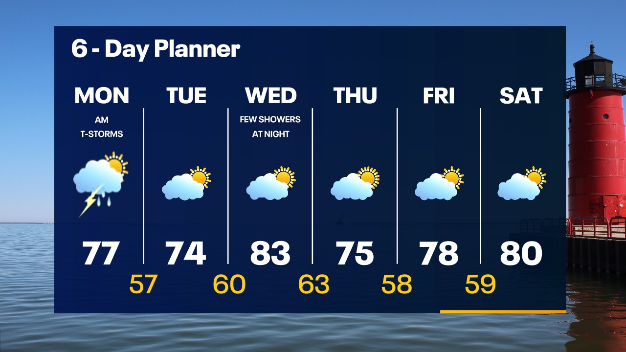
Another batch of showers and t-storms will move through SE Wisconsin overnight, ending around 9am. Mostly cloudy on Monday with highs in the 70s, dropping late in the day.
Another batch of showers and t-storms will move through SE Wisconsin overnight, ending around 9am. Mostly cloudy on Monday with highs in the 70s, dropping late in the day.

Weather Webcast with Tom Wachs
Scattered showers possible this evening with more concentrated rain moving in from the west overnight. Heavy rain is possible. The rain will taper off after 8am. Drying out by afternoon with highs in the 70s.
Scattered showers possible this evening with more concentrated rain moving in from the west overnight. Heavy rain is possible. The rain will taper off after 8am. Drying out by afternoon with highs in the 70s.
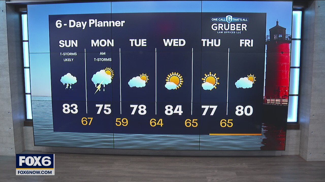
Weather Webcast with Eric Manges
Off and on scattered showers and storms are possible throughout the day. Flood concerns continue through tomorrow morning. Periods of heavy rain will be possible which is the main concern. Skies slowly clear out Monday afternoon and we return to less muggy conditions.
Off and on scattered showers and storms are possible throughout the day. Flood concerns continue through tomorrow morning. Periods of heavy rain will be possible which is the main concern. Skies slowly clear out Monday afternoon and we return to less muggy conditions.