

Weather Webcast with Chief Meteorologist Rob Haswell
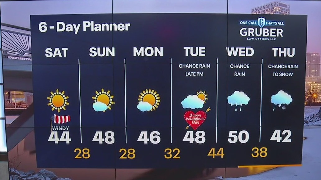
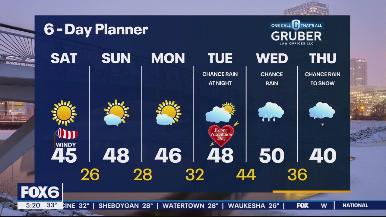
A broad area of high pressure dominates our weekend forecast keeping us sunny and helping to warm us well above average. Highs today will reach the low to mid 40s and push to the upper 40s by Sunday.
A broad area of high pressure dominates our weekend forecast keeping us sunny and helping to warm us well above average. Highs today will reach the low to mid 40s and push to the upper 40s by Sunday.
Weather Webcast with Meteorologist Eric Manges
FOX6 News at 5 offers the day's news, weather, and sports in southeast Wisconsin, the nation, and the world.
FOX6 News at 5 offers the day's news, weather, and sports in southeast Wisconsin, the nation, and the world.
Weather Webcast with Meteorologist Stephanie Barichello
Plenty of sunshine and warmth ahead, starting this weekend. Next chance for rain arrives Tuesday night and Wednesday.
Plenty of sunshine and warmth ahead, starting this weekend. Next chance for rain arrives Tuesday night and Wednesday.
Weather webcast with Rob Haswell
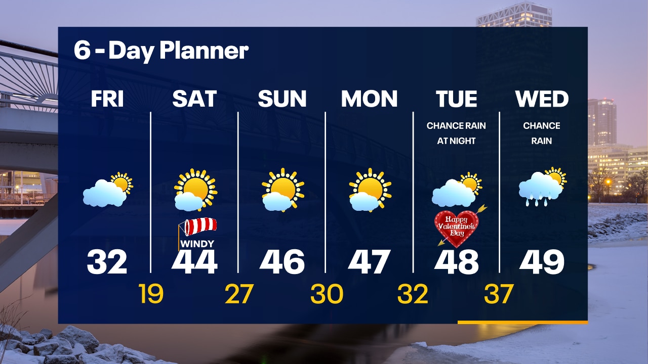
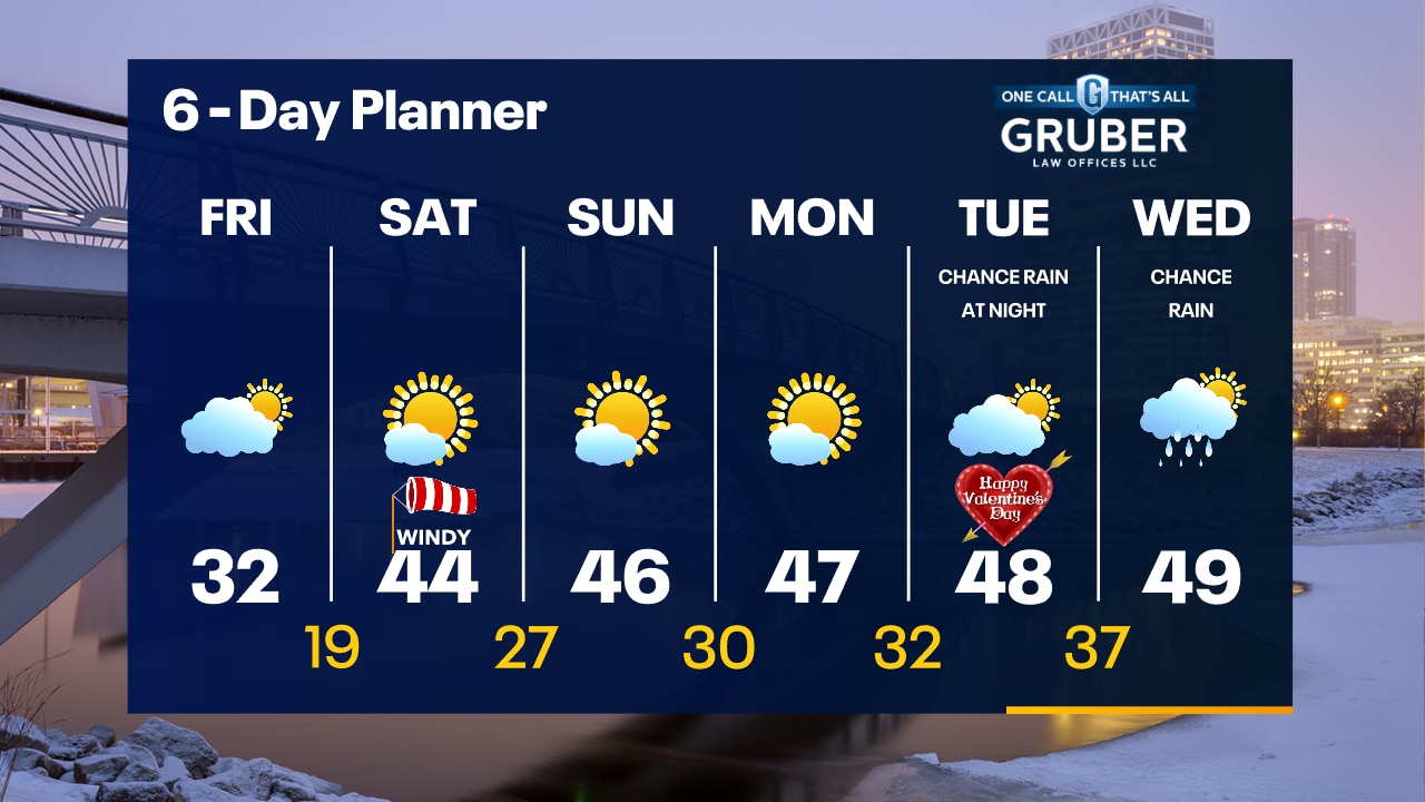
A large area of high pressure is building into our region today to clear us up and bring ample sunshine after a few morning clouds. As the center of the high pushes east, we get on the warmer side and temperatures go from the 30s today well into the 40s for the weekend. We stay sunny and dry through Saturday, Sunday and Monday but should see rain return Tuesday night into Wednesday. We warm even further on Wednesday with highs nearing 50 degrees!
A large area of high pressure is building into our region today to clear us up and bring ample sunshine after a few morning clouds. As the center of the high pushes east, we get on the warmer side and temperatures go from the 30s today well into the 40s for the weekend. We stay sunny and dry through Saturday, Sunday and Monday but should see rain return Tuesday night into Wednesday. We warm even further on Wednesday with highs nearing 50 degrees!
Weather Webcast with Tom Wachs
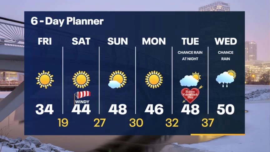
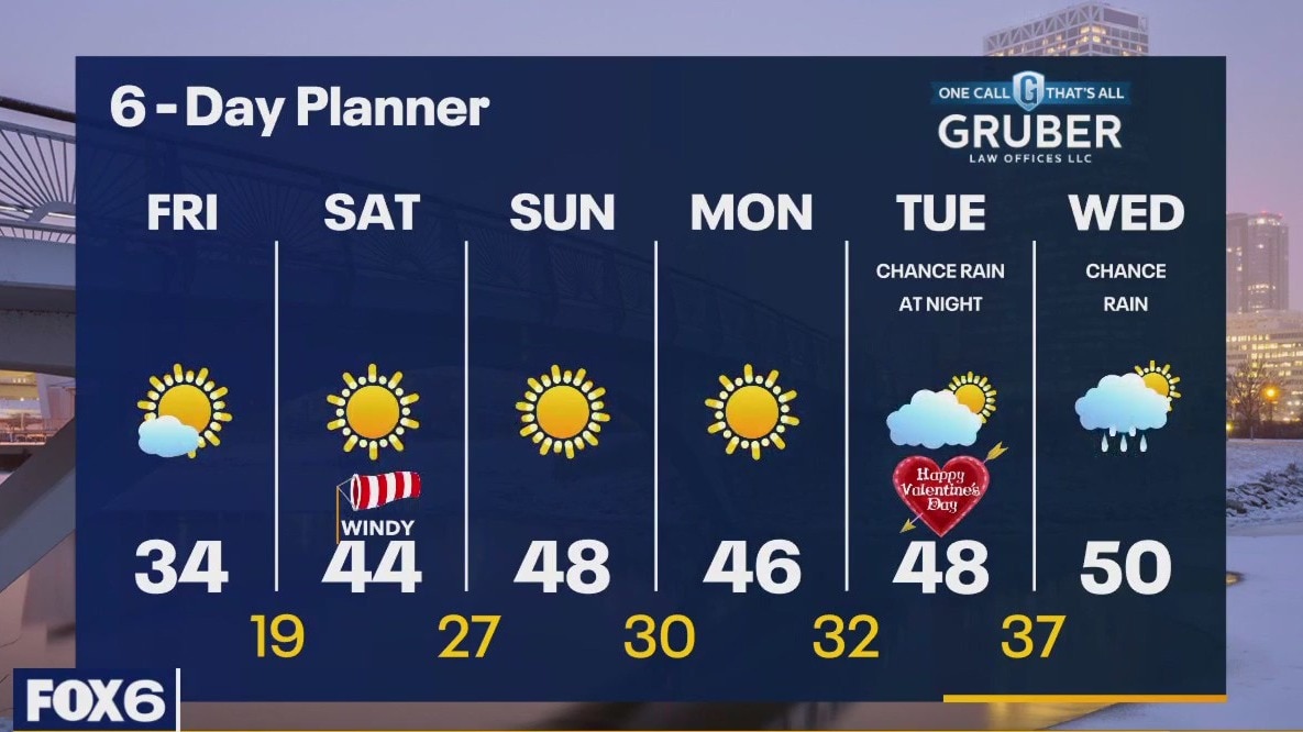
Cloudy and breezy overnight. Patchy icy spots possible as temperatures drop below freezing. Clearing skies on Friday, breezy with highs in the low 30s.
Cloudy and breezy overnight. Patchy icy spots possible as temperatures drop below freezing. Clearing skies on Friday, breezy with highs in the low 30s.
Weather Webcast with Tom Wachs
Rain/snow coming to an end this evening. Watch out for icy spots on roads late tonight. Temperatures dropping into the 20s overnight. Sun returns on Friday with highs in the low 30s.
Rain/snow coming to an end this evening. Watch out for icy spots on roads late tonight. Temperatures dropping into the 20s overnight. Sun returns on Friday with highs in the low 30s.
Weather Webcast with Meteorologist Stephanie Barichello
Heavy snow, rain and sleet continue this afternoon with several inches expected north and northwest of Milwaukee. Drying out tonight with sunshine returning later Friday into the weekend. Warming back into the 40s by Saturday.
Heavy snow, rain and sleet continue this afternoon with several inches expected north and northwest of Milwaukee. Drying out tonight with sunshine returning later Friday into the weekend. Warming back into the 40s by Saturday.

Weather webcast with Rob Haswell
A low passes to our south and east today bringing rain and snow to our area. A Winter Weather Advisory begins at 6am today for Washington, Dodge, Sheboygan, Fond du Lac and Jefferson counties. A few inches of slushy, wet snow are expected for areas under the Winter Weather Advisory with lesser amounts farther to the south and east. We clear up and cool down a bit for Friday but warm back to the low 40s this weekend with ample sunshine.
A low passes to our south and east today bringing rain and snow to our area. A Winter Weather Advisory begins at 6am today for Washington, Dodge, Sheboygan, Fond du Lac and Jefferson counties. A few inches of slushy, wet snow are expected for areas under the Winter Weather Advisory with lesser amounts farther to the south and east. We clear up and cool down a bit for Friday but warm back to the low 40s this weekend with ample sunshine.
Weather Webcast with Meteorologist Eric Manges
FOX6 News at 5 offers the day's news, weather, and sports in southeast Wisconsin, the nation, and the world.
FOX6 News at 5 offers the day's news, weather, and sports in southeast Wisconsin, the nation, and the world.
Weather webcast with Rob Haswell
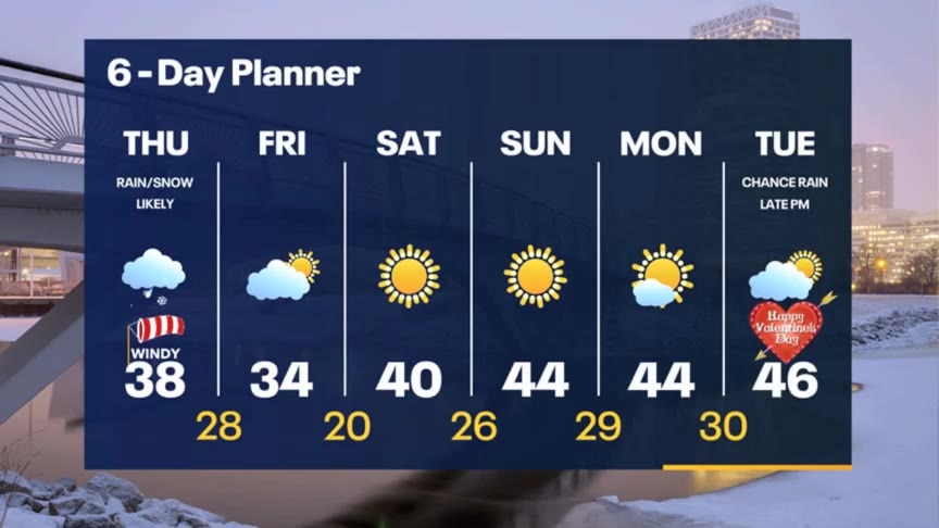
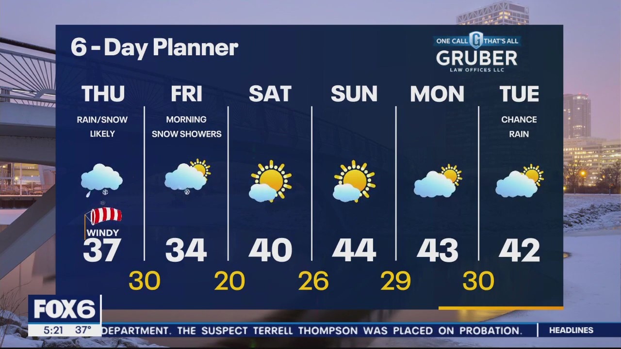
High pressure moves east of our area today with early sunshine making way for more clouds. A strong low arrives overnight with rain, snow and strong wind gusts. Highs will fall from the mid to upper 40s today into the mid to upper 30s tomorrow. A Winter Weather Advisory starts at 6am on Thursday. Several inches of snow are possible in Washington, Dodge, Sheboygan, Jefferson and Fond du Lac counties. As that low exits we can expect snow showers on Friday. We clear up and warm up this weekend and early next week.
High pressure moves east of our area today with early sunshine making way for more clouds. A strong low arrives overnight with rain, snow and strong wind gusts. Highs will fall from the mid to upper 40s today into the mid to upper 30s tomorrow. A Winter Weather Advisory starts at 6am on Thursday. Several inches of snow are possible in Washington, Dodge, Sheboygan, Jefferson and Fond du Lac counties. As that low exits we can expect snow showers on Friday. We clear up and warm up this weekend and early next week.
Weather Webcast with Meteorologist Eric Manges
FOX6 News at 9 offers the day's news. weather, and sports in southeast Wisconsin, the nation, and the world.
FOX6 News at 9 offers the day's news. weather, and sports in southeast Wisconsin, the nation, and the world.
Weather Webcast with Meteorologist Eric Manges
Widespread rain and then a little bit of snow Thursday. We could get almost an inch of rain when it's all said and done.
Widespread rain and then a little bit of snow Thursday. We could get almost an inch of rain when it's all said and done.
Weather Webcast with Meteorologist Stephanie Barichello
Clouds slowly decrease later this evening then clear out overnight. Sunny and mild Wednesday then rain returns Wednesday night and changes to snow in spots Thursday. A few inches of slush possible far west and north.
Clouds slowly decrease later this evening then clear out overnight. Sunny and mild Wednesday then rain returns Wednesday night and changes to snow in spots Thursday. A few inches of slush possible far west and north.

Weather webcast with Rob Haswell
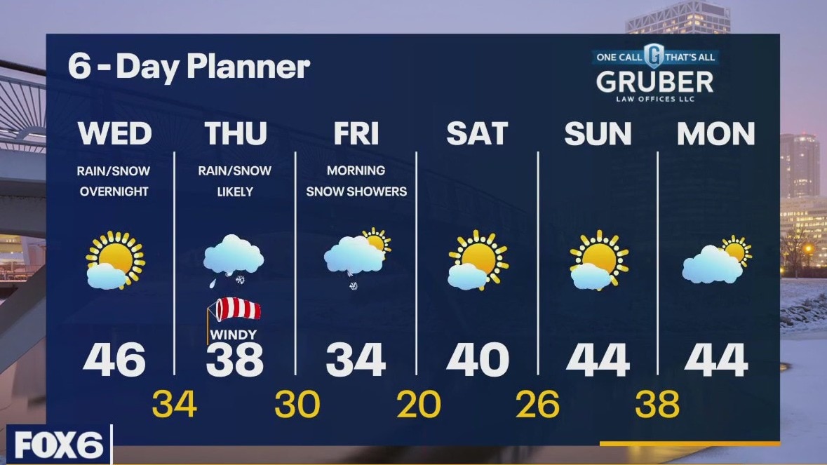
Last night's low moves farther east this morning and high pressure builds across the region to calm and clear things. Highs today have already occurred in the upper 40s, but we will cool to the low 40s this afternoon before falling into the 20s tonight. Wednesday will be pleasant with some sun and a high in the low to mid 40s but by late in the day a low arrives with rain likely. Rain will continue into Thursday and as the low exits, we cool and transition from rain to snow with little to no accumulation in the Milwaukee Metro or south, but a few inches are possible farther north and west.
Last night's low moves farther east this morning and high pressure builds across the region to calm and clear things. Highs today have already occurred in the upper 40s, but we will cool to the low 40s this afternoon before falling into the 20s tonight. Wednesday will be pleasant with some sun and a high in the low to mid 40s but by late in the day a low arrives with rain likely. Rain will continue into Thursday and as the low exits, we cool and transition from rain to snow with little to no accumulation in the Milwaukee Metro or south, but a few inches are possible farther north and west.
Weather Webcast with Meteorologist Stephanie Barichello
Scattered showers tonight then some sunshine returns Tuesday and Wednesday. Rain return Wednesday night then changes to a very wet, slushy snow Thursday.
Scattered showers tonight then some sunshine returns Tuesday and Wednesday. Rain return Wednesday night then changes to a very wet, slushy snow Thursday.
Weather Webcast with Meteorologist Stephanie Barichello
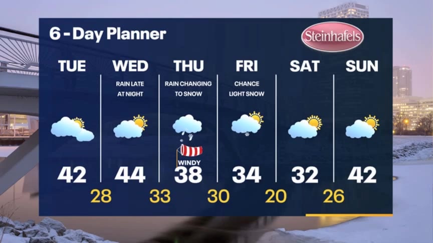
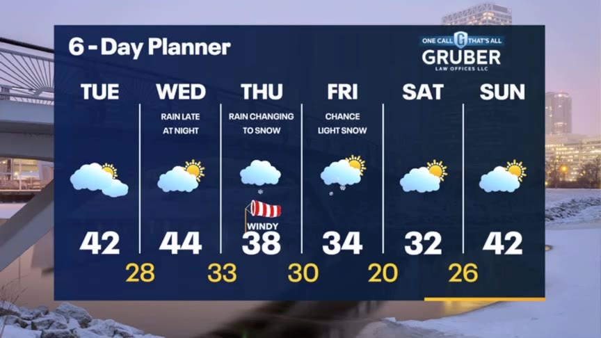
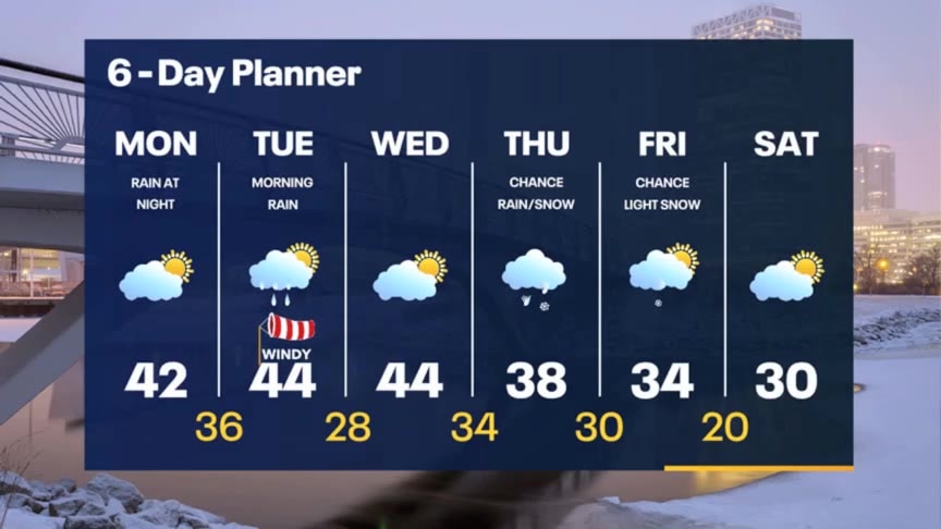
Light rain and windy tonight, then decreasing clouds Tuesday with highs in the 40s. Still mild Wednesday then rain changes to slushy snow Thursday as temperatures drop back into the 30s. Warming back to 40s by Sunday.
Light rain and windy tonight, then decreasing clouds Tuesday with highs in the 40s. Still mild Wednesday then rain changes to slushy snow Thursday as temperatures drop back into the 30s. Warming back to 40s by Sunday.
Weather Webcast With Lisa Michaels
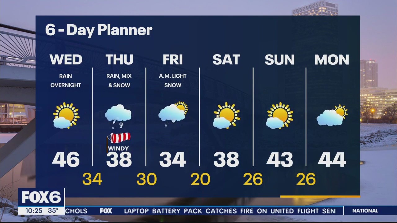
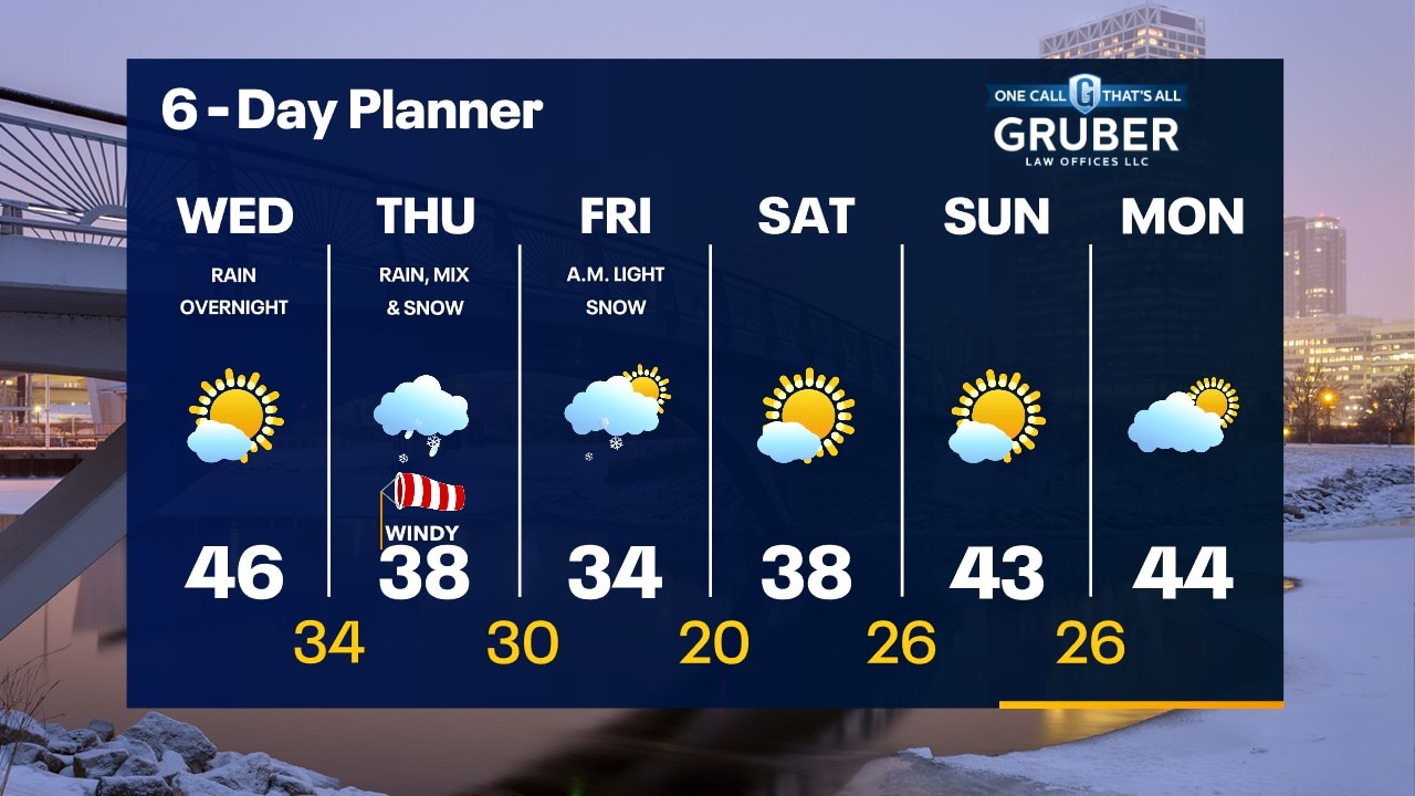
Mostly sunny skies transitioning to partly cloudy by the afternoon. An approaching low will bring rain late evening and overnight into Tuesday morning. Drizzly/Isolated Rain Shower possible early Tuesday, but most of the day will remain dry. Clouds should begin to clear by the afternoon on Tuesday. Mild temperatures during the first half of the week with the chance of reaching the low 40s. The warmth will end by the end of the week as another system moves in. We could see rain on Thursday with the transition into snow by Friday.
Mostly sunny skies transitioning to partly cloudy by the afternoon. An approaching low will bring rain late evening and overnight into Tuesday morning. Drizzly/Isolated Rain Shower possible early Tuesday, but most of the day will remain dry. Clouds should begin to clear by the afternoon on Tuesday. Mild temperatures during the first half of the week with the chance of reaching the low 40s. The warmth will end by the end of the week as another system moves in. We could see rain on Thursday with the transition into snow by Friday.
Weather webcast with Rob Haswell
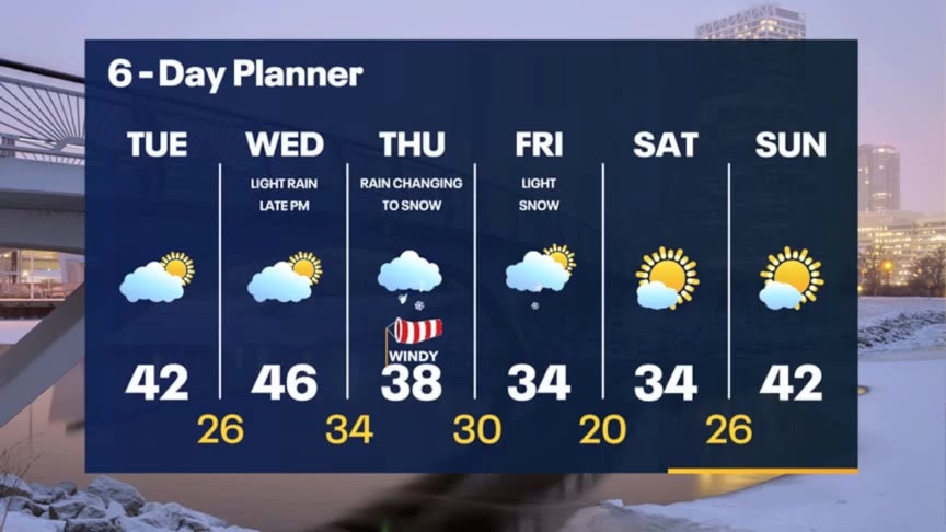
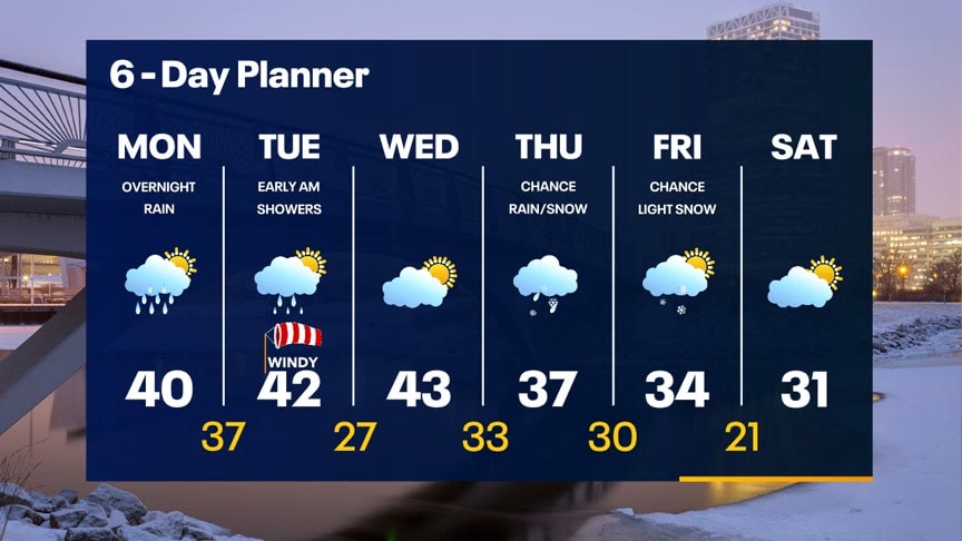
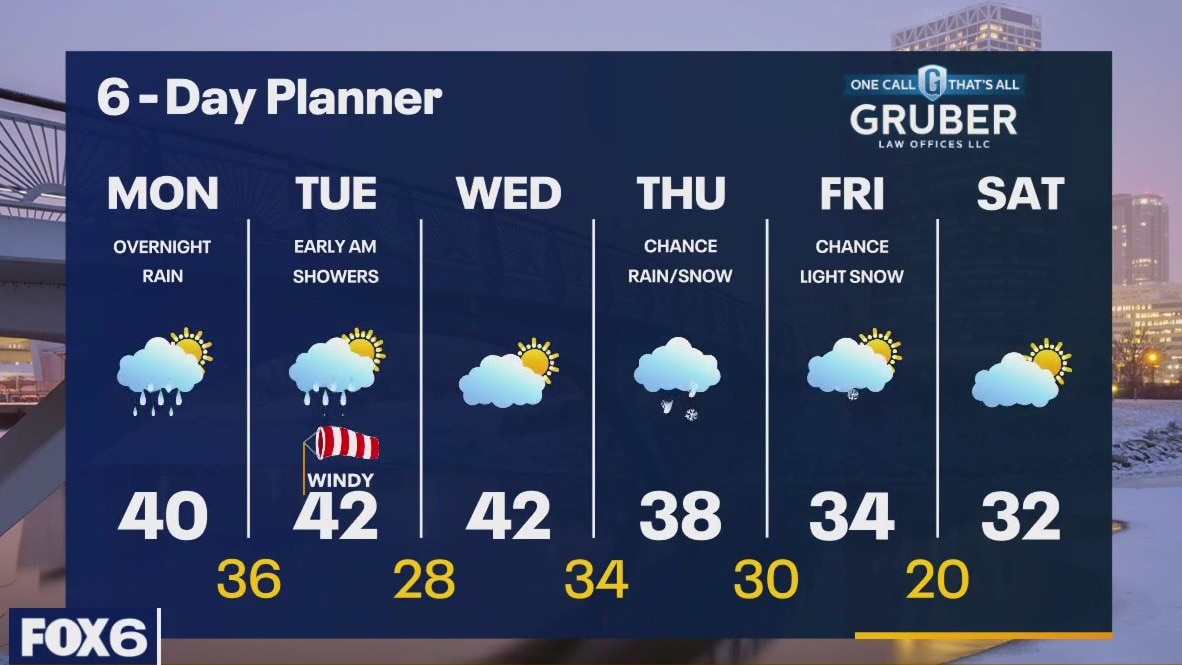
A chilly morning but we should warm to near 40 by the end of the day. An approaching low will bring rain late evening and overnight into Tuesday morning. We dry up for most of the day on Tuesday and into Wednesday but another system arrives on Thursday. Thursday's system is currently tracking in a way that would bring some areas snow with other areas getting rain. We will continue to track this system as it gets closer with particular attention to that rain/snow line.
A chilly morning but we should warm to near 40 by the end of the day. An approaching low will bring rain late evening and overnight into Tuesday morning. We dry up for most of the day on Tuesday and into Wednesday but another system arrives on Thursday. Thursday's system is currently tracking in a way that would bring some areas snow with other areas getting rain. We will continue to track this system as it gets closer with particular attention to that rain/snow line.
Weather Webcast with Meteorologist Stephanie Barichello
Colder tonight with lows in the 20s then we're back to 40s tomorrow. Rain likely Monday night into early Tuesday then cooling later in the week with a chance for rain changing to snow.
Colder tonight with lows in the 20s then we're back to 40s tomorrow. Rain likely Monday night into early Tuesday then cooling later in the week with a chance for rain changing to snow.
Weather Webcast with Meteorologist Lisa Michaels
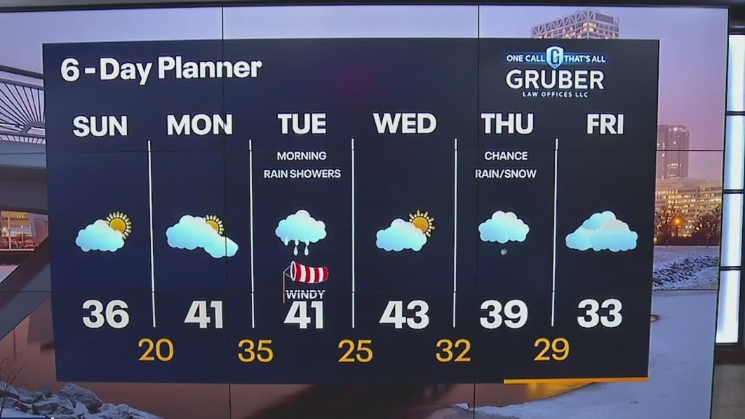
Ending off the weekend with temperatures above freezing and dry. Warmer temperatures will reach the 40s for the first half of next week. A system will bring rain with the small chance of a mix Monday night into early Tuesday. Another system Thursday into Friday could bring rain with snow possible on the backside.
Ending off the weekend with temperatures above freezing and dry. Warmer temperatures will reach the 40s for the first half of next week. A system will bring rain with the small chance of a mix Monday night into early Tuesday. Another system Thursday into Friday could bring rain with snow possible on the backside.