

Weather Webcast with Tom Wachs
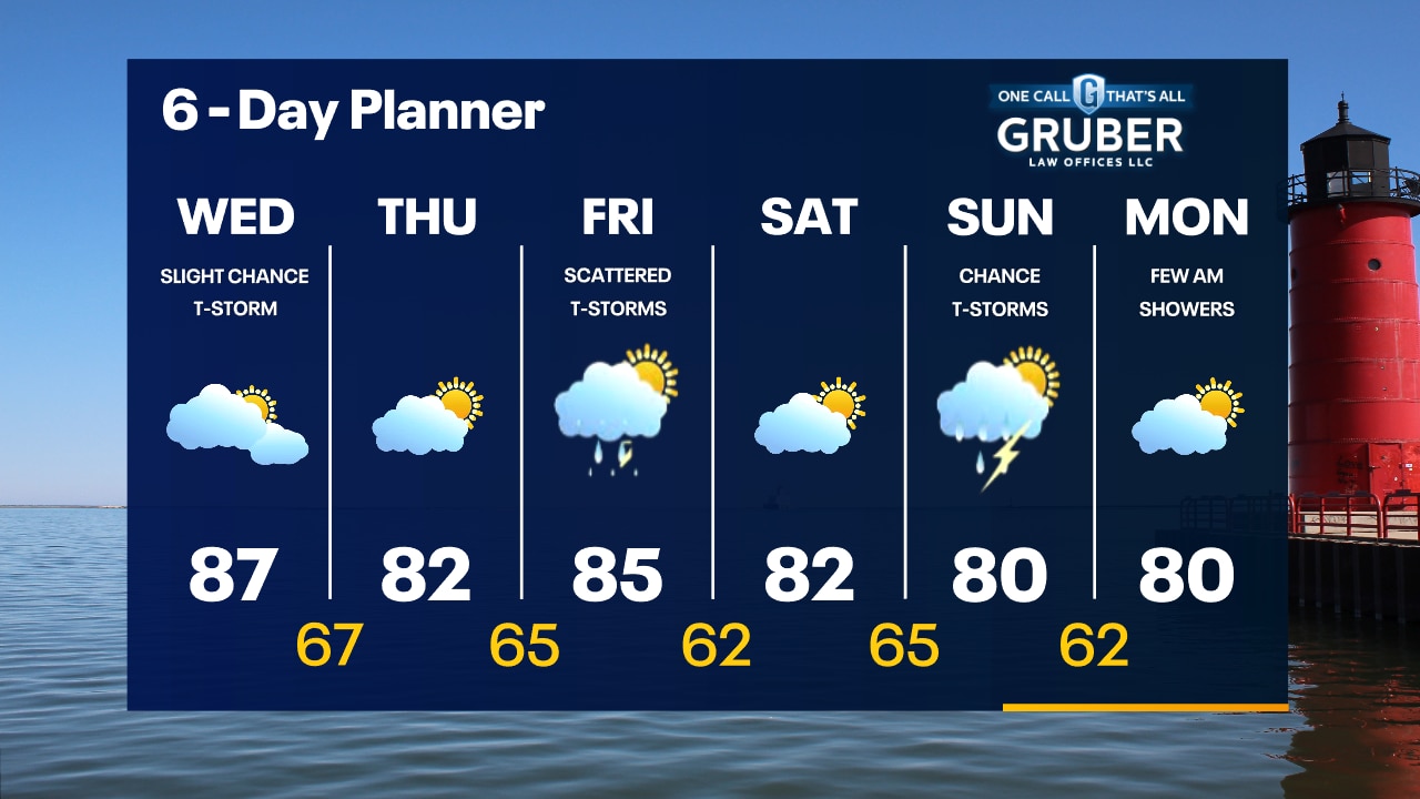
An isolated t-storm is possible through sunset, otherwise temperatures dropping into the 60s overnight. Warm and mostly cloudy on Wednesday. Slight chance for a rain shower or t-storm.
An isolated t-storm is possible through sunset, otherwise temperatures dropping into the 60s overnight. Warm and mostly cloudy on Wednesday. Slight chance for a rain shower or t-storm.

Weather Webcast with Meteorologist Eric Manges
Isolated showers possible into the evening and warming up tomorrow
Isolated showers possible into the evening and warming up tomorrow
Weather webcast with Lisa Michaels
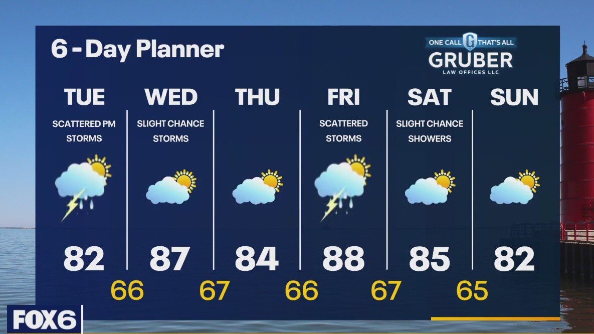
Partly cloudy with morning temps in the upper 50s to mid 60s. Partly sunny and warmer on Tuesday with scattered afternoon t-storms. Highs in the low 80s. A slight chance for a t-storms on Wednesday. Warm and humid with a high in the upper 80s. 80s continue through the end of the week with another chance for scattered t-storms on Friday.
Partly cloudy with morning temps in the upper 50s to mid 60s. Partly sunny and warmer on Tuesday with scattered afternoon t-storms. Highs in the low 80s. A slight chance for a t-storms on Wednesday. Warm and humid with a high in the upper 80s. 80s continue through the end of the week with another chance for scattered t-storms on Friday.
Weather Webcast with Tom Wachs
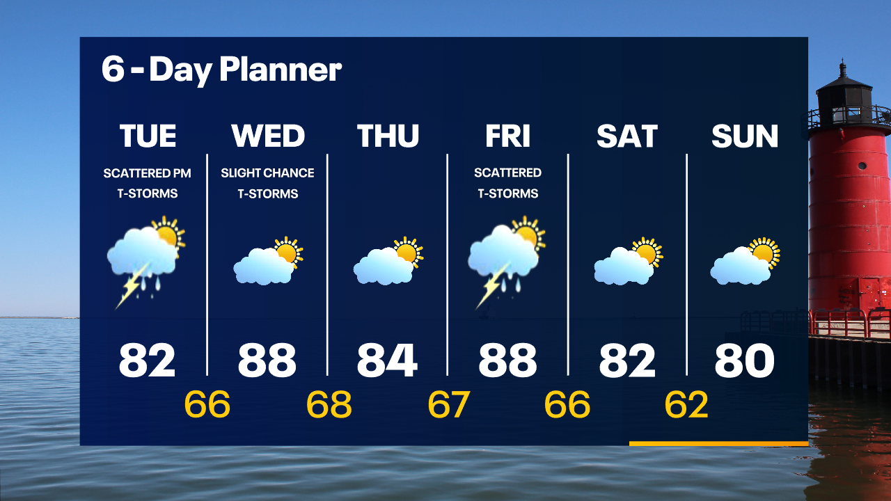
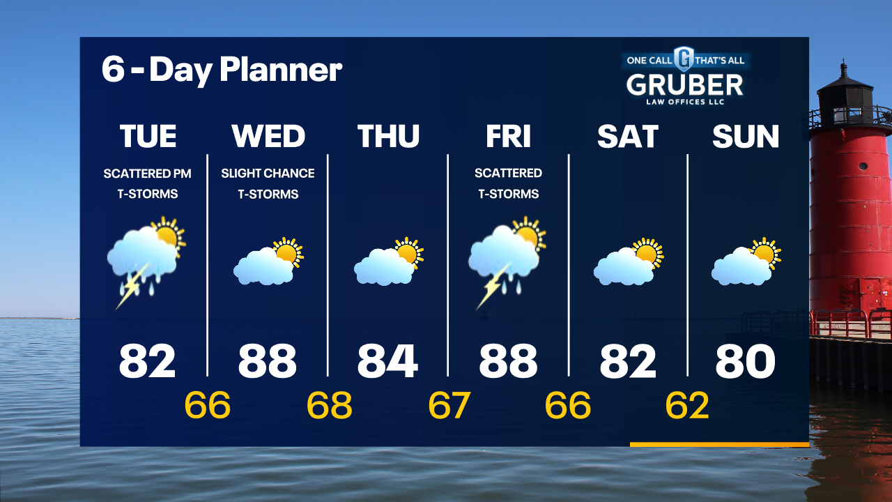
Partly cloudy overnight with temperatures in the 60s. Partly sunny with scattered showers/storms on Tuesday afternoon and evening. Highs in the low 80s.
Partly cloudy overnight with temperatures in the 60s. Partly sunny with scattered showers/storms on Tuesday afternoon and evening. Highs in the low 80s.
Weather Webcast with Tom Wachs
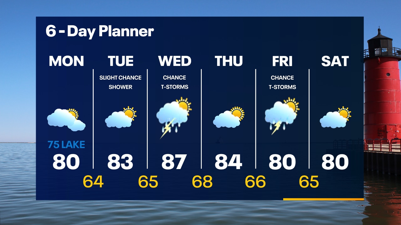
Partly cloudy tonight with temperatures dropping into the 60s. Partly sunny and warmer on Tuesday with scattered afternoon/evening showers and t-storms. Highs in the low 80s.
Partly cloudy tonight with temperatures dropping into the 60s. Partly sunny and warmer on Tuesday with scattered afternoon/evening showers and t-storms. Highs in the low 80s.

Weather webcast with Lisa Michaels
Mostly cloudy skies with cooler temps in the 60s Monday morning. Highs around 80 inland, mid-70s near the lake. Northeasterly winds will keep it cooler near the lake and bring a high swim risk. Partly sunny and warmer on Tuesday with a slight chance for a rain shower. Scattered t-storms are possible on Wednesday with warm and humid conditions. 80s continue through the end of the week with another chance or storms Friday.
Mostly cloudy skies with cooler temps in the 60s Monday morning. Highs around 80 inland, mid-70s near the lake. Northeasterly winds will keep it cooler near the lake and bring a high swim risk. Partly sunny and warmer on Tuesday with a slight chance for a rain shower. Scattered t-storms are possible on Wednesday with warm and humid conditions. 80s continue through the end of the week with another chance or storms Friday.
Weather Webcast with Tom Wachs
An isolated rain shower and patchy fog possible overnight with temperatures in the 60s. Mostly cloudy and breezy on Monday with highs between 75-80.
An isolated rain shower and patchy fog possible overnight with temperatures in the 60s. Mostly cloudy and breezy on Monday with highs between 75-80.

Weather Webcast with Tom Wachs
Mostly cloudy tonight. An isolated shower possible along with some patchy fog. Temperatures dropping into the 60s. Mostly cloudy on Monday with highs between 75-80.
Mostly cloudy tonight. An isolated shower possible along with some patchy fog. Temperatures dropping into the 60s. Mostly cloudy on Monday with highs between 75-80.
Weather Webcast with Meteorologist Lisa Michaels
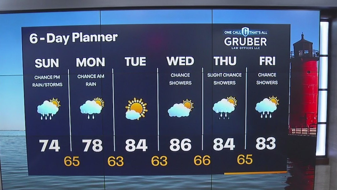
A few showers/storms possible today especially closer to the WI-IL border. Most areas stay dry with highs in the mid 70s. Nice weather returns on Tuesday, but more scattered rain is in theforecast next week.
A few showers/storms possible today especially closer to the WI-IL border. Most areas stay dry with highs in the mid 70s. Nice weather returns on Tuesday, but more scattered rain is in theforecast next week.

Weather Webcast with Meteorologist Eric Manges
Rain chances not as likely Sunday and Monday but the chance is still there
Rain chances not as likely Sunday and Monday but the chance is still there
Weather Webcast with Meteorologist Eric Manges
Rain and storm potential returns Sunday afternoon and continues into Monday
Rain and storm potential returns Sunday afternoon and continues into Monday
Weather Webcast with Meteorologist Lisa Michaels
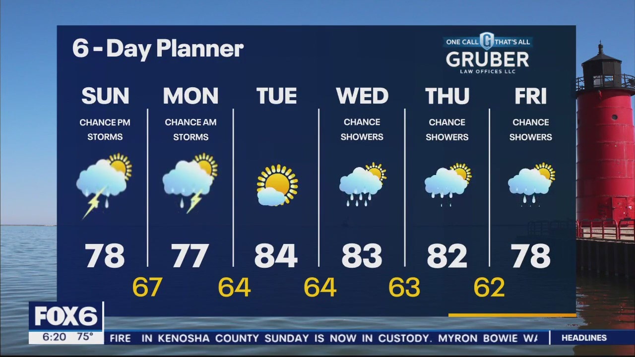
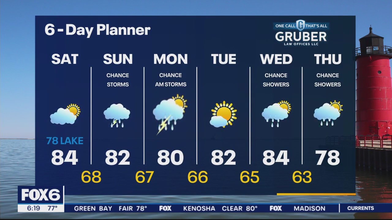
A nice way to start off the weekend Saturday with partly cloudy skies and high temps in the upper 70s lakefront to mid 80s inland. Chances of rain and storms come into play Sunday through Monday.
A nice way to start off the weekend Saturday with partly cloudy skies and high temps in the upper 70s lakefront to mid 80s inland. Chances of rain and storms come into play Sunday through Monday.
Weather Webcast with Meteorologist Eric Manges
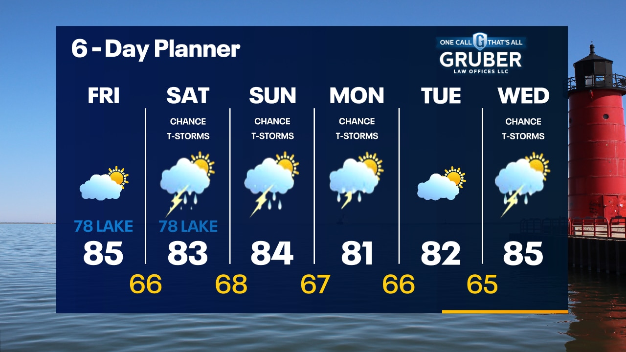
Storm chances this weekend and more activity by mid next week
Storm chances this weekend and more activity by mid next week
Weather webcast with Rob Haswell
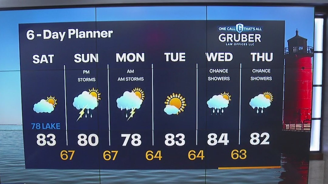
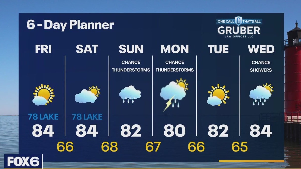
High pressure returns to the area today for a calm day today and into Saturday. Highs return to seasonal averages in the low 80s with lows in the 60s. A low moves our way by Sunday with rain likely and a chance for thunderstorms. We get windy on Monday.
High pressure returns to the area today for a calm day today and into Saturday. Highs return to seasonal averages in the low 80s with lows in the 60s. A low moves our way by Sunday with rain likely and a chance for thunderstorms. We get windy on Monday.

Weather Webcast with Tom Wachs
Showers and t-storms will come to an end overnight. Patchy fog with temperatures in the 60s. Partly sunny on Friday with highs in the 70s near the lake, low-to-mid 80s inland.
Showers and t-storms will come to an end overnight. Patchy fog with temperatures in the 60s. Partly sunny on Friday with highs in the 70s near the lake, low-to-mid 80s inland.
Weather Webcast with Tom Wachs
Scattered t-storms this evening. Temperatures will drop through the 70s and into the 60s overnight. Partly sunny and cooler on Friday. Highs in the 70s near the lake, 80s inland.
Scattered t-storms this evening. Temperatures will drop through the 70s and into the 60s overnight. Partly sunny and cooler on Friday. Highs in the 70s near the lake, 80s inland.
Weather Webcast With Lisa Michaels
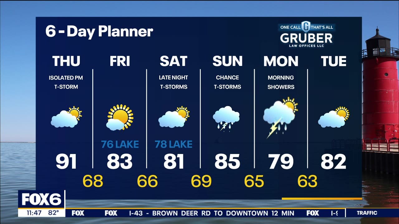
Hot today with highs near 90 and a slight chance for an isolated shower late evening. High humidity will make it feel like the mid 90s this afternoon. More seasonable tomorrow with partly sunny skies to end the work week. Rain chances increase Saturday night. Better rain/storms chances last Sunday through early Monday morning. Possible chance for a few strong storms depending on track of low. Long term we're looking cooler than average heading into mid-August.
Hot today with highs near 90 and a slight chance for an isolated shower late evening. High humidity will make it feel like the mid 90s this afternoon. More seasonable tomorrow with partly sunny skies to end the work week. Rain chances increase Saturday night. Better rain/storms chances last Sunday through early Monday morning. Possible chance for a few strong storms depending on track of low. Long term we're looking cooler than average heading into mid-August.
Weather webcast with Eric Manges
Hot today with highs near 90 and a slight chance for an isolated shower late evening. More seasonable tomorrow with partly sunny skies to end the work week. Saturday night rain chances move in and continue throughout Sunday and finally subside Monday afternoon. Long term we're looking cooler than average heading into mid-August.
Hot today with highs near 90 and a slight chance for an isolated shower late evening. More seasonable tomorrow with partly sunny skies to end the work week. Saturday night rain chances move in and continue throughout Sunday and finally subside Monday afternoon. Long term we're looking cooler than average heading into mid-August.
Weather Webcast with Tom Wachs
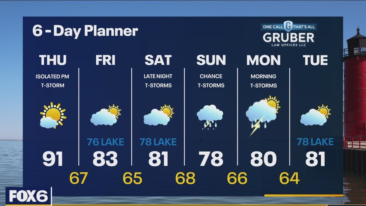
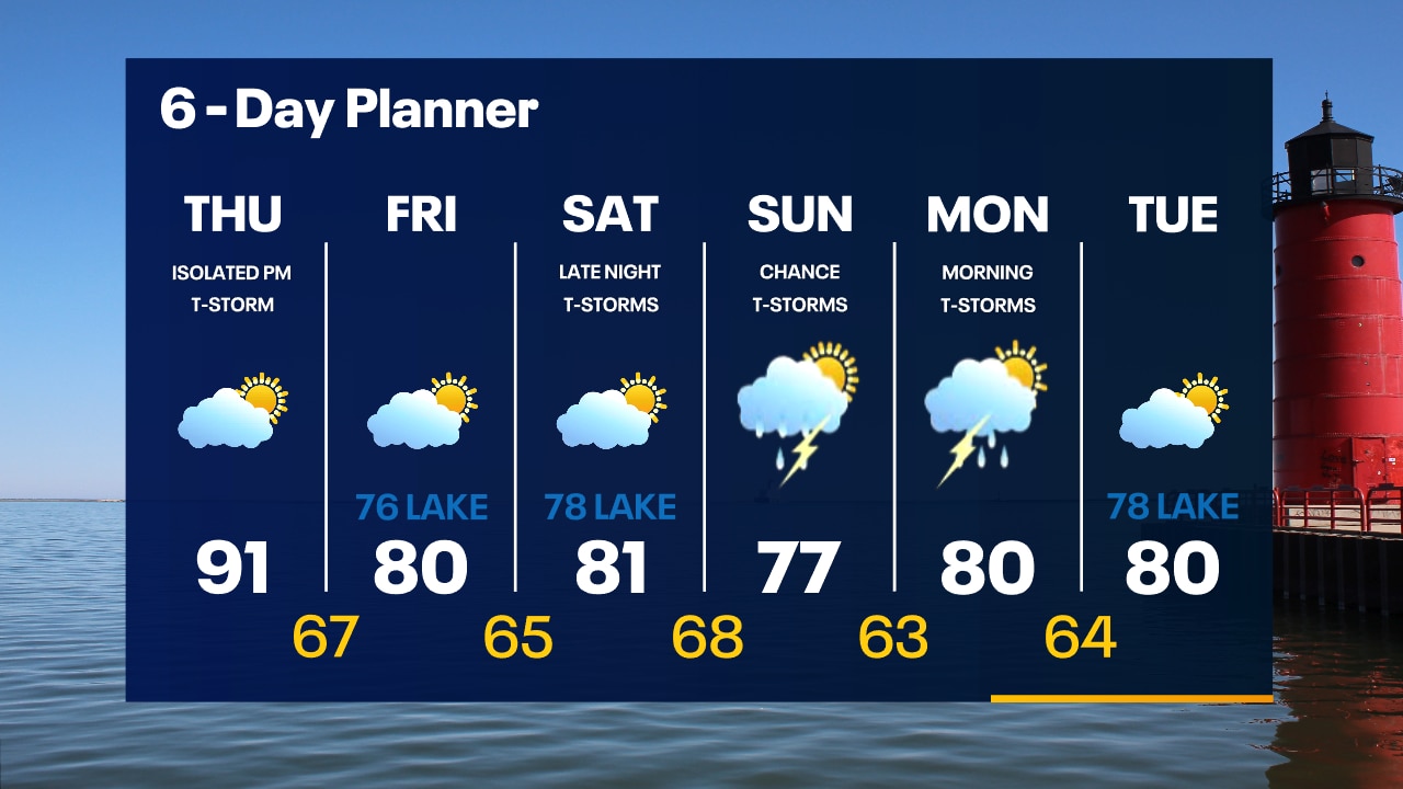
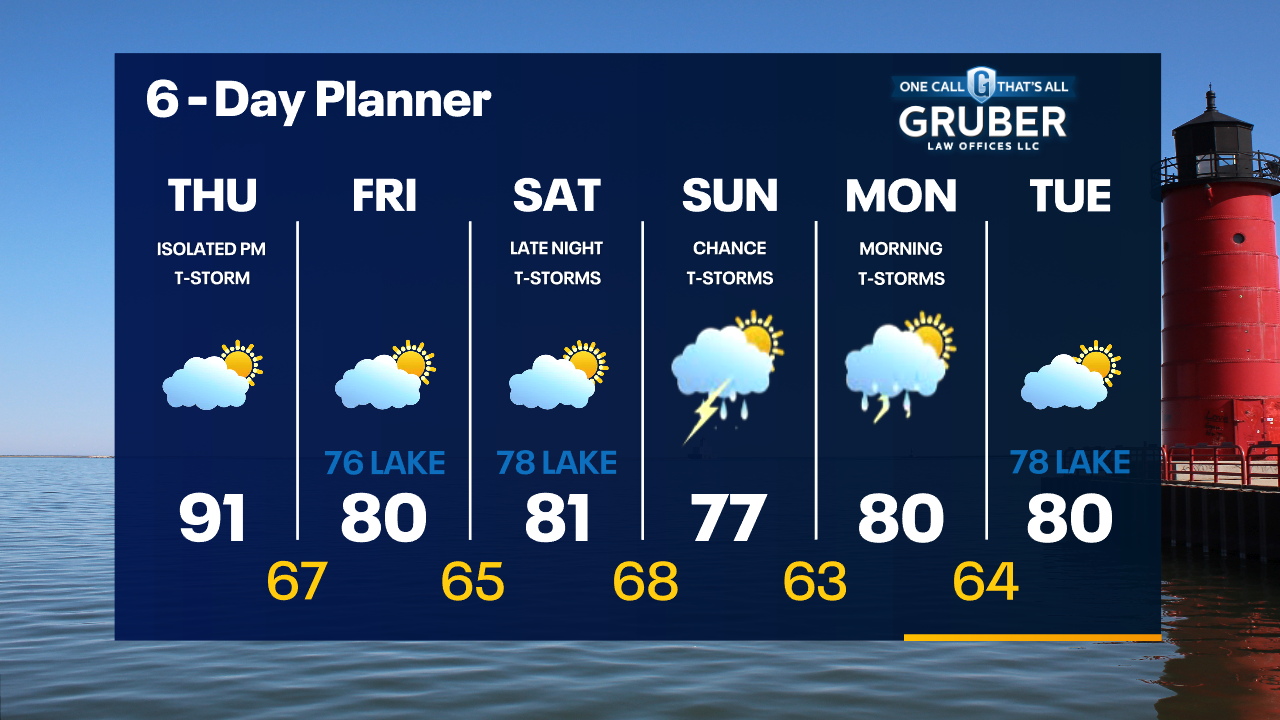
Patchy fog overnight with temperatures in the 60s. Partly sunny, hot and humid on Thursday. Highs in the low 90s with a heat index in the mid-90s. An isolated t-storm is possible on Thursday night.
Patchy fog overnight with temperatures in the 60s. Partly sunny, hot and humid on Thursday. Highs in the low 90s with a heat index in the mid-90s. An isolated t-storm is possible on Thursday night.
Weather Webcast with Tom Wachs
Partly cloudy tonight with temperatures dropping through the 70s and into the 60s. Partly sunny, hot and humid on Thursday with a high in the low 90s and a heat index in the mid-90s.
Partly cloudy tonight with temperatures dropping through the 70s and into the 60s. Partly sunny, hot and humid on Thursday with a high in the low 90s and a heat index in the mid-90s.