


Weather webcast with Rob Haswell
Another dry day today with ample sunshine and just a few more clouds this afternoon. We will warm into the upper 70s inland with low 70s lakeside due to a breeze off of Lake Michigan in the afternoon.
Another dry day today with ample sunshine and just a few more clouds this afternoon. We will warm into the upper 70s inland with low 70s lakeside due to a breeze off of Lake Michigan in the afternoon.

Weather Webcast with Stephanie Barichello
Another sunny day ahead Friday, then a chance for thunderstorms on Saturday. Sunshine is back Sunday, along with 70s, then expect a warm, muggy and stormy start to the week.
Another sunny day ahead Friday, then a chance for thunderstorms on Saturday. Sunshine is back Sunday, along with 70s, then expect a warm, muggy and stormy start to the week.
Weather Webcast with Stephanie Barichello
Another clear and cool night with temperatures dropping into the 40s. Sunny Friday, then rain returns Saturday. One more sunny day Sunday, then warm, humid and stormy through at least Wednesday of next week.
Another clear and cool night with temperatures dropping into the 40s. Sunny Friday, then rain returns Saturday. One more sunny day Sunday, then warm, humid and stormy through at least Wednesday of next week.
Weather webcast with Rob Haswell
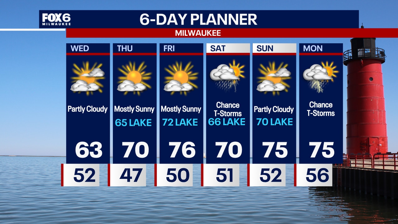
High pressure builds over the area for a few days with dry conditions and ample sunshine today! With a breeze off of Lake Michigan today, it will be in the low 60s lakeside but warm to near 70 inland.
High pressure builds over the area for a few days with dry conditions and ample sunshine today! With a breeze off of Lake Michigan today, it will be in the low 60s lakeside but warm to near 70 inland.
Weather Webcast with Tom Wachs
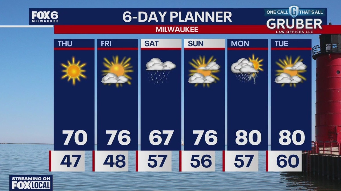
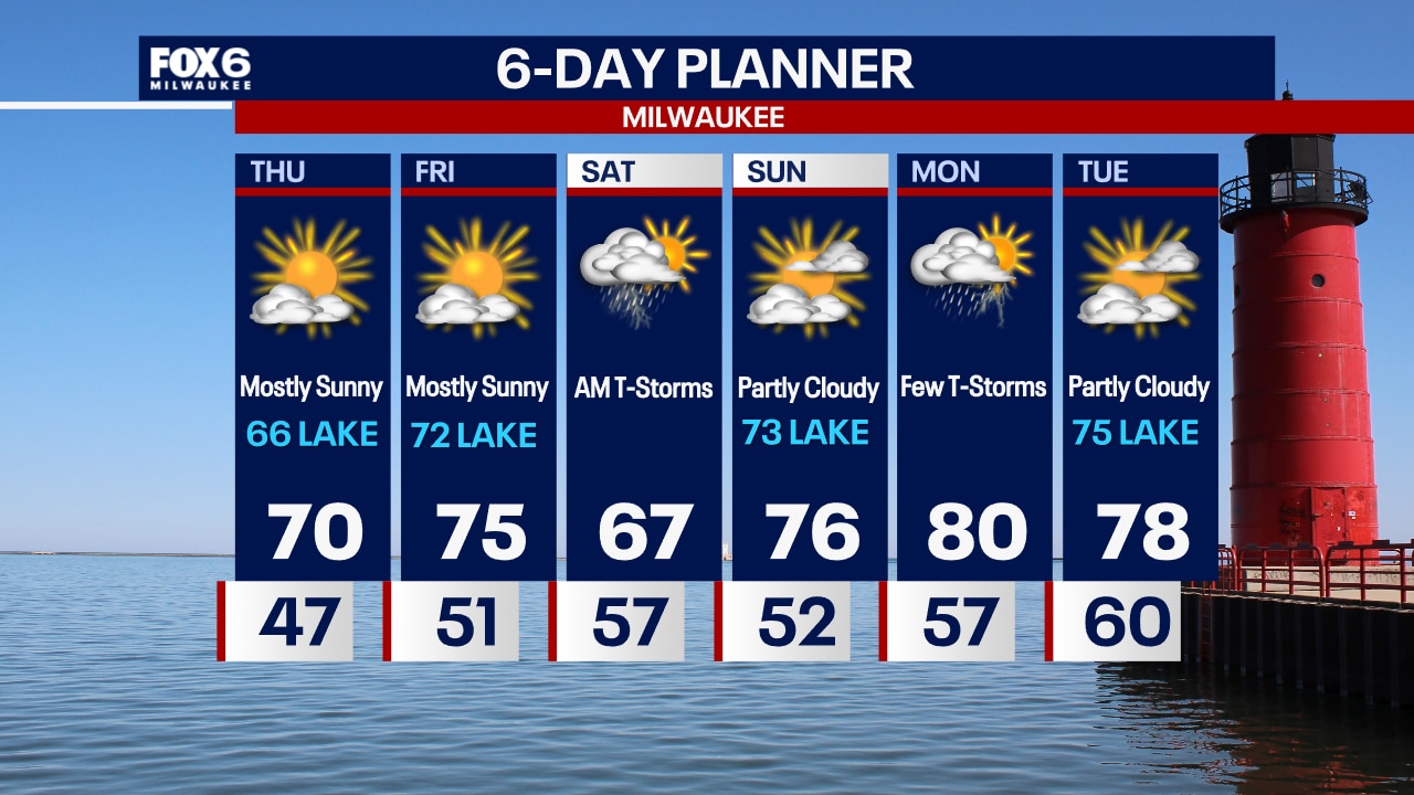
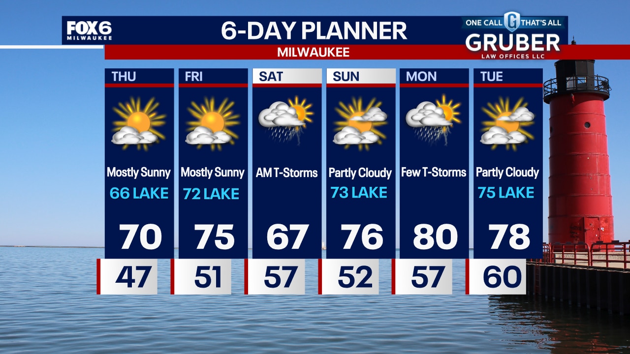
Clear and crisp overnight with temperatures in the 40s. Mostly sunny on Thursday with highs around 70 inland, mid-60s near the lake. More sun on Friday with highs in the 70s.
Clear and crisp overnight with temperatures in the 40s. Mostly sunny on Thursday with highs around 70 inland, mid-60s near the lake. More sun on Friday with highs in the 70s.
Weather Webcast with Chief Meteorologist Tom Wachs
Mostly clear tonight with temperatures falling through the 50s and into the 40s overnight. Mostly sunny on Thursday with highs in the mid-60s near the lake to around 70 inland.
Mostly clear tonight with temperatures falling through the 50s and into the 40s overnight. Mostly sunny on Thursday with highs in the mid-60s near the lake to around 70 inland.

Weather webcast with Lisa Michaels
Clouds clear early on Wednesday with sunshine returning and highs in the low to mid 60s. Upper 50s near the lake.
Clouds clear early on Wednesday with sunshine returning and highs in the low to mid 60s. Upper 50s near the lake.
Weather Webcast with Tom Wachs
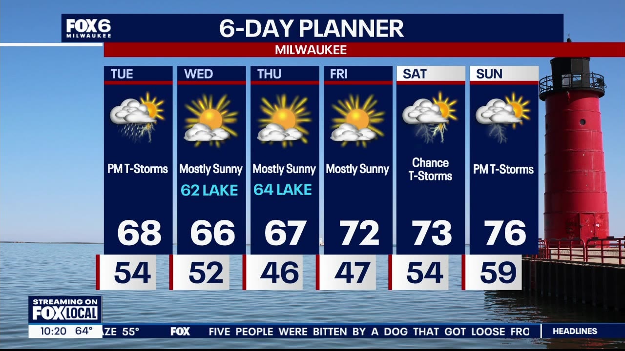
T-Storms will taper off by 7-8pm, but moderate rain continues through 12am. Flooding is possible, please be alert for high water this evening.
T-Storms will taper off by 7-8pm, but moderate rain continues through 12am. Flooding is possible, please be alert for high water this evening.

Weather webcast with Rob Haswell
A brief lull in the showers later this morning but more showers and a chance for thunderstorms later today and into the evening as a cold front passes through from the north. Highs today will reach the upper 60s.
A brief lull in the showers later this morning but more showers and a chance for thunderstorms later today and into the evening as a cold front passes through from the north. Highs today will reach the upper 60s.
Weather webcast with Lisa Michaels
Scattered thunderstorms possible this evening and overnight with temperatures falling into the low to mid 50s. Dry to start Tuesday, then another round of scattered storms in the afternoon and evening. Temperatures will reach into the upper 60s. Sunshine returns Wednesday and continues the rest of the week. It'll be a bit cool, especially lakeside, through Thursday. Storms look possible again heading into the weekend.
Scattered thunderstorms possible this evening and overnight with temperatures falling into the low to mid 50s. Dry to start Tuesday, then another round of scattered storms in the afternoon and evening. Temperatures will reach into the upper 60s. Sunshine returns Wednesday and continues the rest of the week. It'll be a bit cool, especially lakeside, through Thursday. Storms look possible again heading into the weekend.
Weather Webcast with Stephanie Barichello
Scattered thunderstorms return this afternoon and evening. It'll be breezy with highs in the low 70s. We drop into the 50s tonight, then climb back into the 70s Tuesday. Yet another round of afternoon storms expected. Sunshine returns Wednesday and continues the rest of the week.
Scattered thunderstorms return this afternoon and evening. It'll be breezy with highs in the low 70s. We drop into the 50s tonight, then climb back into the 70s Tuesday. Yet another round of afternoon storms expected. Sunshine returns Wednesday and continues the rest of the week.
Weather webcast with Rob Haswell
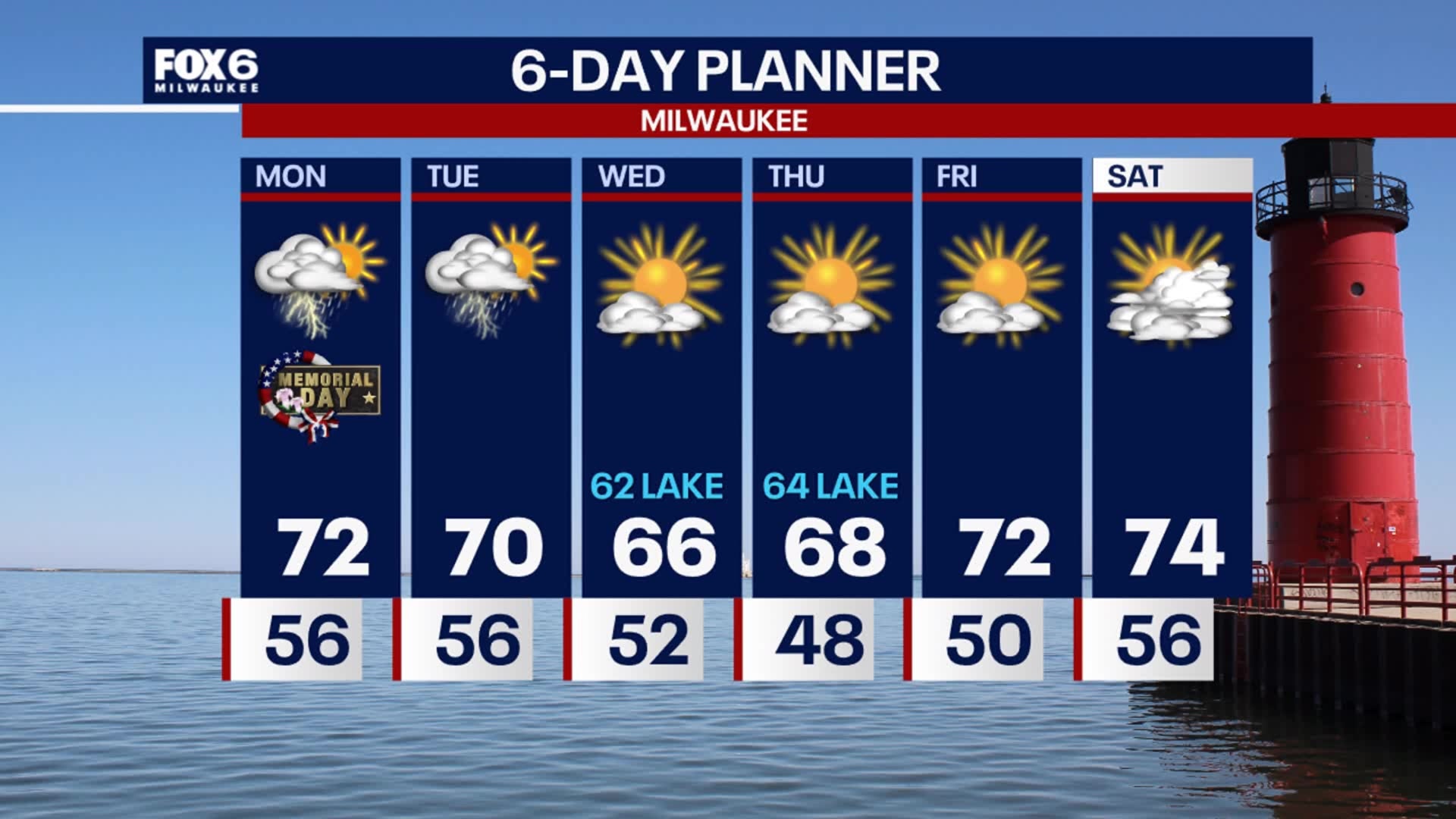
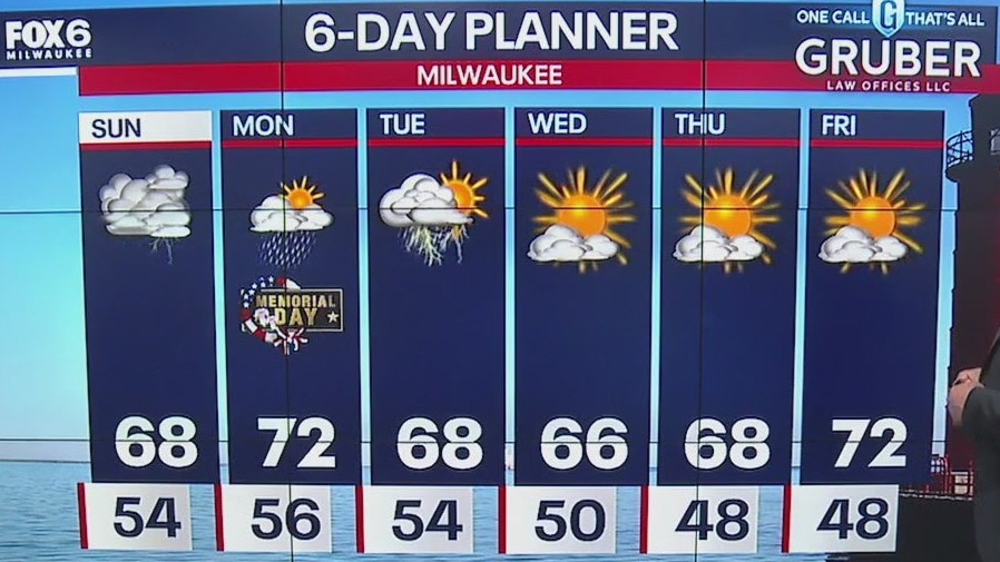
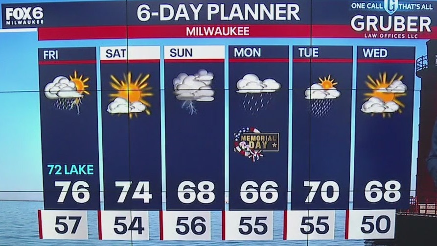
A generally calm start to our Memorial Day. However, isolated showers and thunderstorms are likely later today and into the evening. While strong storms cannot be ruled out, there is very little risk of severe storms today.
A generally calm start to our Memorial Day. However, isolated showers and thunderstorms are likely later today and into the evening. While strong storms cannot be ruled out, there is very little risk of severe storms today.
Weather webcast with Rob Haswell
An area of low pressure passes from western Iowa into northern Michigan over the next 48 hours. As the system moves through our area, we can expect at least two rounds of rain and thunderstorms.
An area of low pressure passes from western Iowa into northern Michigan over the next 48 hours. As the system moves through our area, we can expect at least two rounds of rain and thunderstorms.
Weather Webcast with Stephanie Barichello
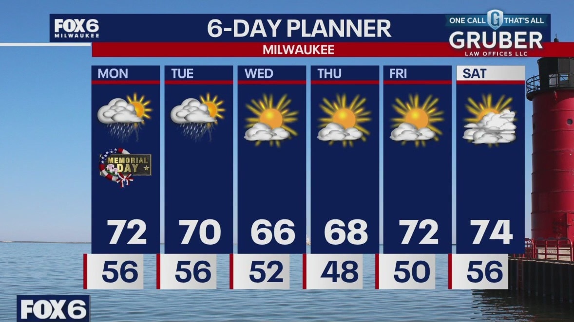
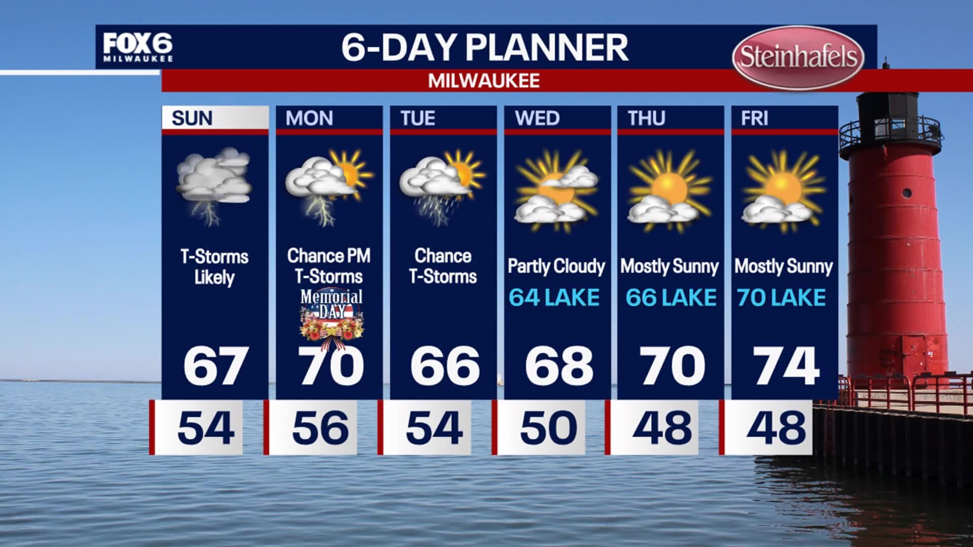
Thunderstorms return Sunday, likely by late morning/midday. Storms are then possible all through the afternoon and evening. More dry time on Memorial Day, then a chance for late afternoon or evening storms again. Temperatures will be warmer, around 70. One final day of storms Tuesday then drying out the rest of the week.
Thunderstorms return Sunday, likely by late morning/midday. Storms are then possible all through the afternoon and evening. More dry time on Memorial Day, then a chance for late afternoon or evening storms again. Temperatures will be warmer, around 70. One final day of storms Tuesday then drying out the rest of the week.

Weather webcast with Lisa Michaels
Beautiful Saturday with mostly sunny skies and highs in the low 70s. Clouds increase tonight another low pressure system that will bring rain and storms on Sunday.
Beautiful Saturday with mostly sunny skies and highs in the low 70s. Clouds increase tonight another low pressure system that will bring rain and storms on Sunday.

Weather Webcast with Stephanie Barichello
Thunderstorms end after 10pm, then sunny on Saturday. Rain returns on Sunday with a few scattered thunderstorms also possible on Memorial Day and Tuesday. Temperatures will mainly be in the 60s and low 70s.
Thunderstorms end after 10pm, then sunny on Saturday. Rain returns on Sunday with a few scattered thunderstorms also possible on Memorial Day and Tuesday. Temperatures will mainly be in the 60s and low 70s.
Weather webcast with Rob Haswell
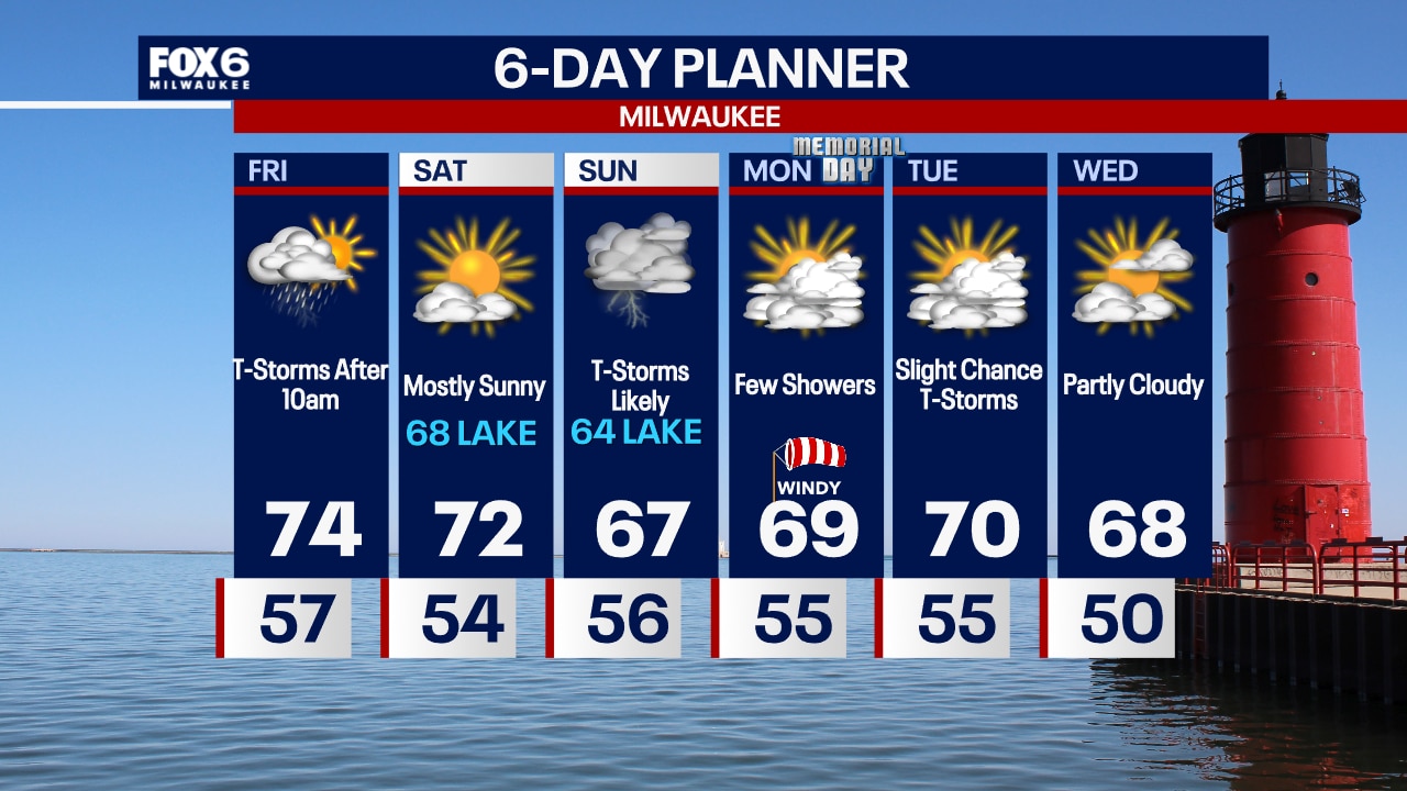
Two rounds of rain and thunderstorms are expected today with the first through the midday and the second in the later afternoon and evening hours. A calmer and clear day on Saturday with highs in the low 70s.
Two rounds of rain and thunderstorms are expected today with the first through the midday and the second in the later afternoon and evening hours. A calmer and clear day on Saturday with highs in the low 70s.
Weather Webcast with Tom Wachs
A few showers north of Milwaukee through sunset, otherwise mostly clear. T-Storms will move in after 10am Friday. Another batch is forecast to develop late in the afternoon into the evening. Some of those storms could be severe.
A few showers north of Milwaukee through sunset, otherwise mostly clear. T-Storms will move in after 10am Friday. Another batch is forecast to develop late in the afternoon into the evening. Some of those storms could be severe.
Weather webcast with Rob Haswell
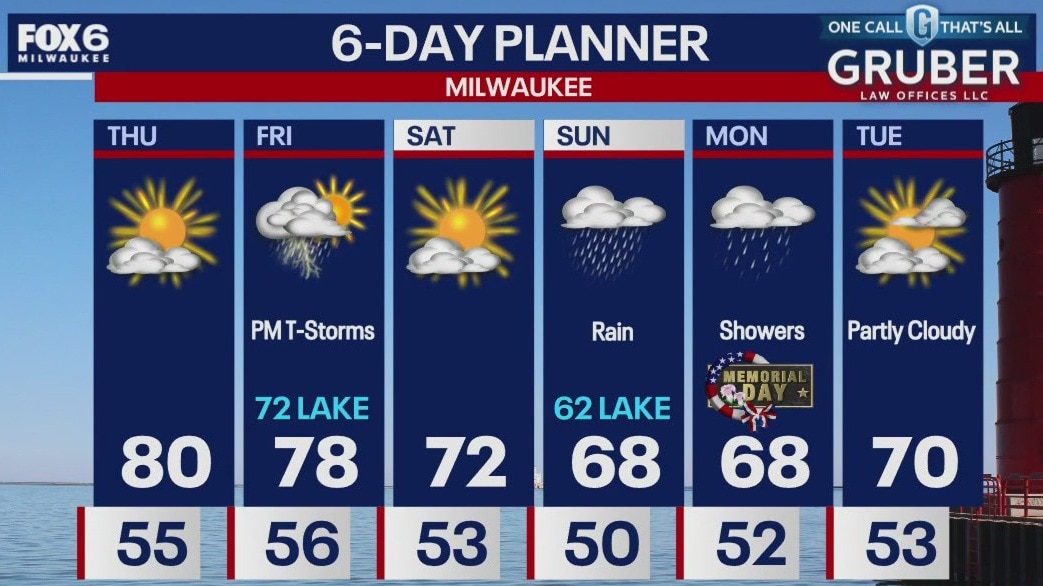
High pressure holds on again today for more sunshine and summer-like temperatures. Highs will be in the upper 70s to low 80s in most areas, and storms return Friday.
High pressure holds on again today for more sunshine and summer-like temperatures. Highs will be in the upper 70s to low 80s in most areas, and storms return Friday.

Weather Webcast with Tom Wachs
Mostly clear overnight with temperatures falling into the 50s. Mostly sunny and warm on Thursday with a high near 80. Thunderstorm chances return on Friday.
Mostly clear overnight with temperatures falling into the 50s. Mostly sunny and warm on Thursday with a high near 80. Thunderstorm chances return on Friday.