


Weather Webcast with Stephanie Barichello
A few more clouds this afternoon then rain returns by late morning Friday. Thunderstorms more likely Friday evening into Saturday morning, a few of which could be strong to severe with gusty wind. Hot and humid Saturday then back to pleasant weather Sunday.
A few more clouds this afternoon then rain returns by late morning Friday. Thunderstorms more likely Friday evening into Saturday morning, a few of which could be strong to severe with gusty wind. Hot and humid Saturday then back to pleasant weather Sunday.
Weather webcast with Rob Haswell
High pressure builds over the area for today with a much cooler and far less humid air mass taking over. High temperatures will fall to the low 70s inland and stay in the upper 60s near Lake Michigan. A low arrives later Friday with more rain and a chance for thunderstorms. There is a Marginal Risk for severe storms Friday. We warm back up a bit on Saturday but cooler air returns Sunday into Monday.
High pressure builds over the area for today with a much cooler and far less humid air mass taking over. High temperatures will fall to the low 70s inland and stay in the upper 60s near Lake Michigan. A low arrives later Friday with more rain and a chance for thunderstorms. There is a Marginal Risk for severe storms Friday. We warm back up a bit on Saturday but cooler air returns Sunday into Monday.

Weather Webcast with Chief Meteorologist Tom Wachs
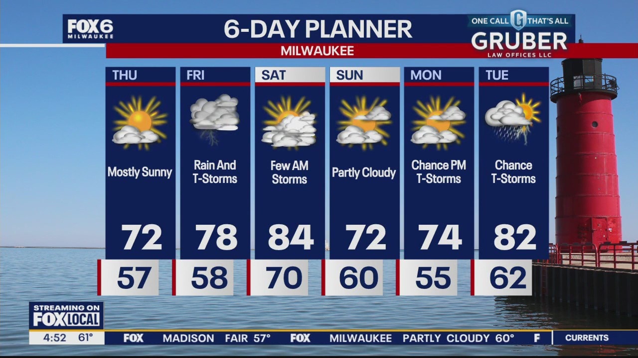
Mostly clear & comfortable overnight. Temperatures dropping into the 50s. Mostly sunny and cooler on Thursday. Highs in the upper 60s on the Summerfest grounds and near the lake, around 70 inland.
Mostly clear & comfortable overnight. Temperatures dropping into the 50s. Mostly sunny and cooler on Thursday. Highs in the upper 60s on the Summerfest grounds and near the lake, around 70 inland.
Weather Webcast with Chief Meteorologist Tom Wachs
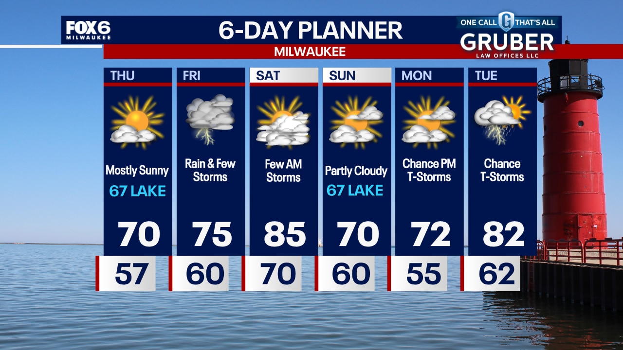
Mostly clear and comfortable tonight. Temperatures dropping through the 60s and settling in the 50s overnight. Mostly sunny on Thursday, much cooler. Highs in the upper 60s to around 70.
Mostly clear and comfortable tonight. Temperatures dropping through the 60s and settling in the 50s overnight. Mostly sunny on Thursday, much cooler. Highs in the upper 60s to around 70.

Weather webcast with Rob Haswell
Temperatures and dew points will lower a bit today from yesterday's maximums. We'll be in the low 80s with dew points in the low 60s and falling. A few showers are possible today but a mostly dry day is expected with some sunshine. We cool further to the low 70s Thursday. Rain returns by Friday and into early Saturday.
Temperatures and dew points will lower a bit today from yesterday's maximums. We'll be in the low 80s with dew points in the low 60s and falling. A few showers are possible today but a mostly dry day is expected with some sunshine. We cool further to the low 70s Thursday. Rain returns by Friday and into early Saturday.

Weather Webcast with Stephanie Barichello
Warm and muggy this evening with storms south of us in northern IL, where a cold front is located. A second front moves through Wednesday morning bringing a few sprinkles, then afternoon sunshine and less humidity. Very pleasant Thursday then rain and humidity return Friday into Saturday morning.
Warm and muggy this evening with storms south of us in northern IL, where a cold front is located. A second front moves through Wednesday morning bringing a few sprinkles, then afternoon sunshine and less humidity. Very pleasant Thursday then rain and humidity return Friday into Saturday morning.
Weather webcast with Rob Haswell
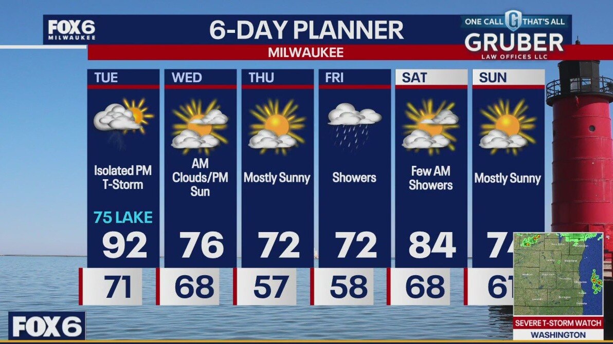
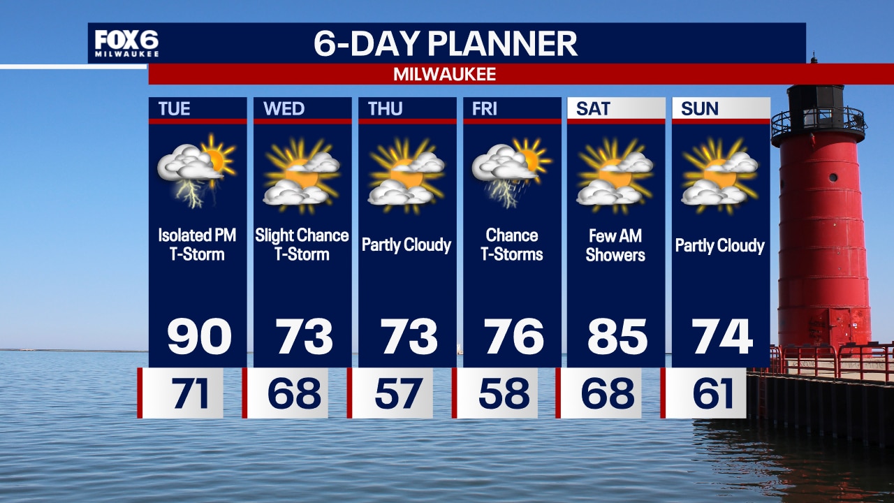
After an early round of strong to severe storms, we calm down but remain hot and humid. Highs will hit the low 90s today with dewpoints in the low 70s. We will cool down and become more comfortable tomorrow and stay dry through Thursday. A chance for rain and thunderstorms returns on Friday but the weekend is looking good.
After an early round of strong to severe storms, we calm down but remain hot and humid. Highs will hit the low 90s today with dewpoints in the low 70s. We will cool down and become more comfortable tomorrow and stay dry through Thursday. A chance for rain and thunderstorms returns on Friday but the weekend is looking good.

Weather Webcast with Chief Meteorologist Tom Wachs
Round 1 of t-storms is moving south into Illinois this evening with a second round possible overnight. A severe line of storms is possible after 2am.
Round 1 of t-storms is moving south into Illinois this evening with a second round possible overnight. A severe line of storms is possible after 2am.
Weather Webcast with Chief Meteorologist Tom Wachs
A squall line of thunderstorms with strong winds is possible overnight...starting after 1am and ending by 6am. Please stay tuned for updates.
A squall line of thunderstorms with strong winds is possible overnight...starting after 1am and ending by 6am. Please stay tuned for updates.

Weather webcast with Stephanie Barichello
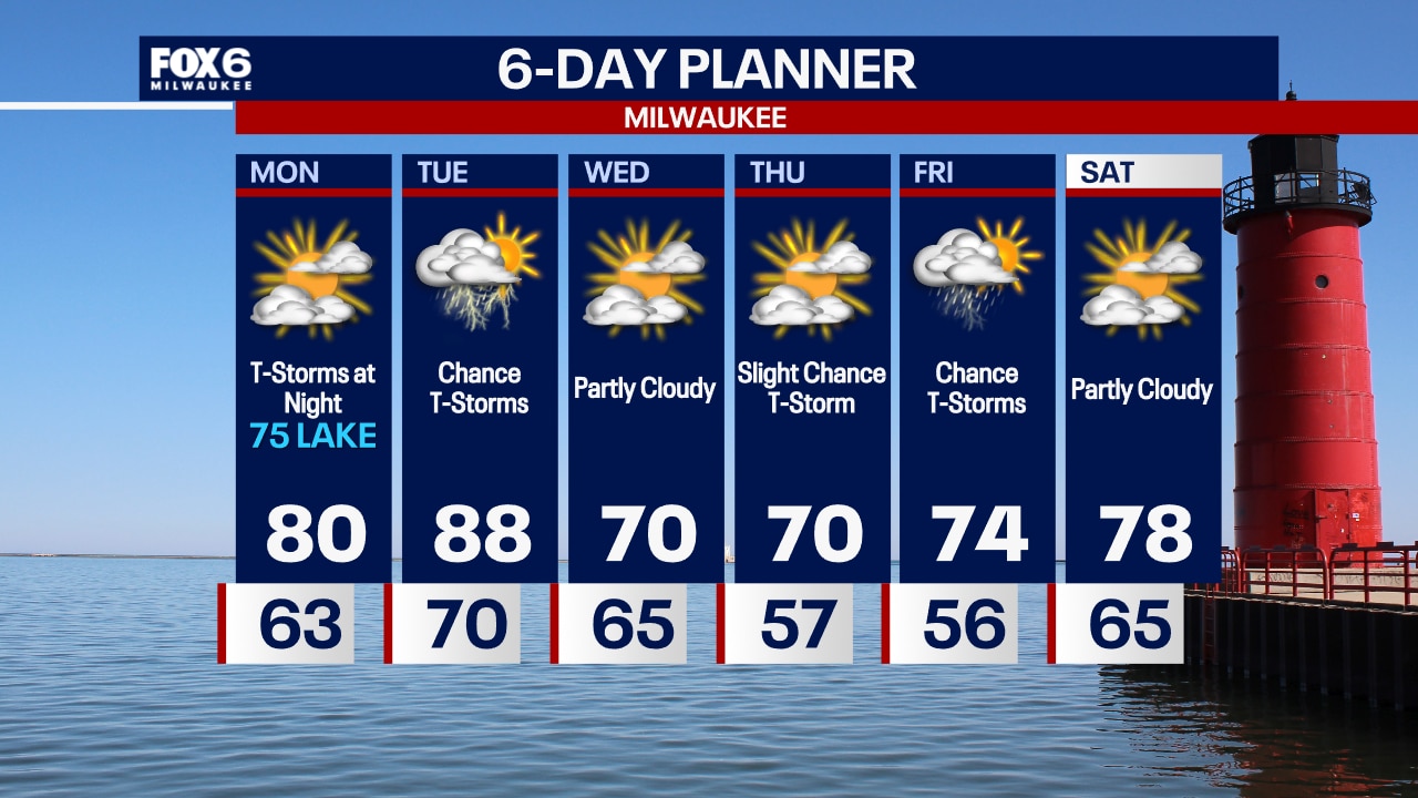
Partly sunny today with temperatures around 80 inland, mid 70s lakeside. Thunderstorms are possible late tonight/early Tuesday morning and could be severe again. Then we could see a few more thunderstorms during the day Tuesday, also possibly severe. It'll be hot and humid with a high around 88. Much cooler and calmer midweek, then storms return Friday into Saturday
Partly sunny today with temperatures around 80 inland, mid 70s lakeside. Thunderstorms are possible late tonight/early Tuesday morning and could be severe again. Then we could see a few more thunderstorms during the day Tuesday, also possibly severe. It'll be hot and humid with a high around 88. Much cooler and calmer midweek, then storms return Friday into Saturday
Weather Webcast with Chief Meteorologist Tom Wachs
An isolated shower overnight otherwise mostly clear. Partly sunny on Monday with a high around 80 inland, mid-70s near the lake. T-Storm chances return Monday night.
An isolated shower overnight otherwise mostly clear. Partly sunny on Monday with a high around 80 inland, mid-70s near the lake. T-Storm chances return Monday night.

Weather Webcast with Chief Meteorologist Tom Wachs
An isolated rain shower is possible this evening with temperatures dropping through the 60s. Partly sunny on Monday with a high around 80 inland, 75 near the lake. T-Storms are possible Monday night.
An isolated rain shower is possible this evening with temperatures dropping through the 60s. Partly sunny on Monday with a high around 80 inland, 75 near the lake. T-Storms are possible Monday night.

Weather webcast with Rob Haswell
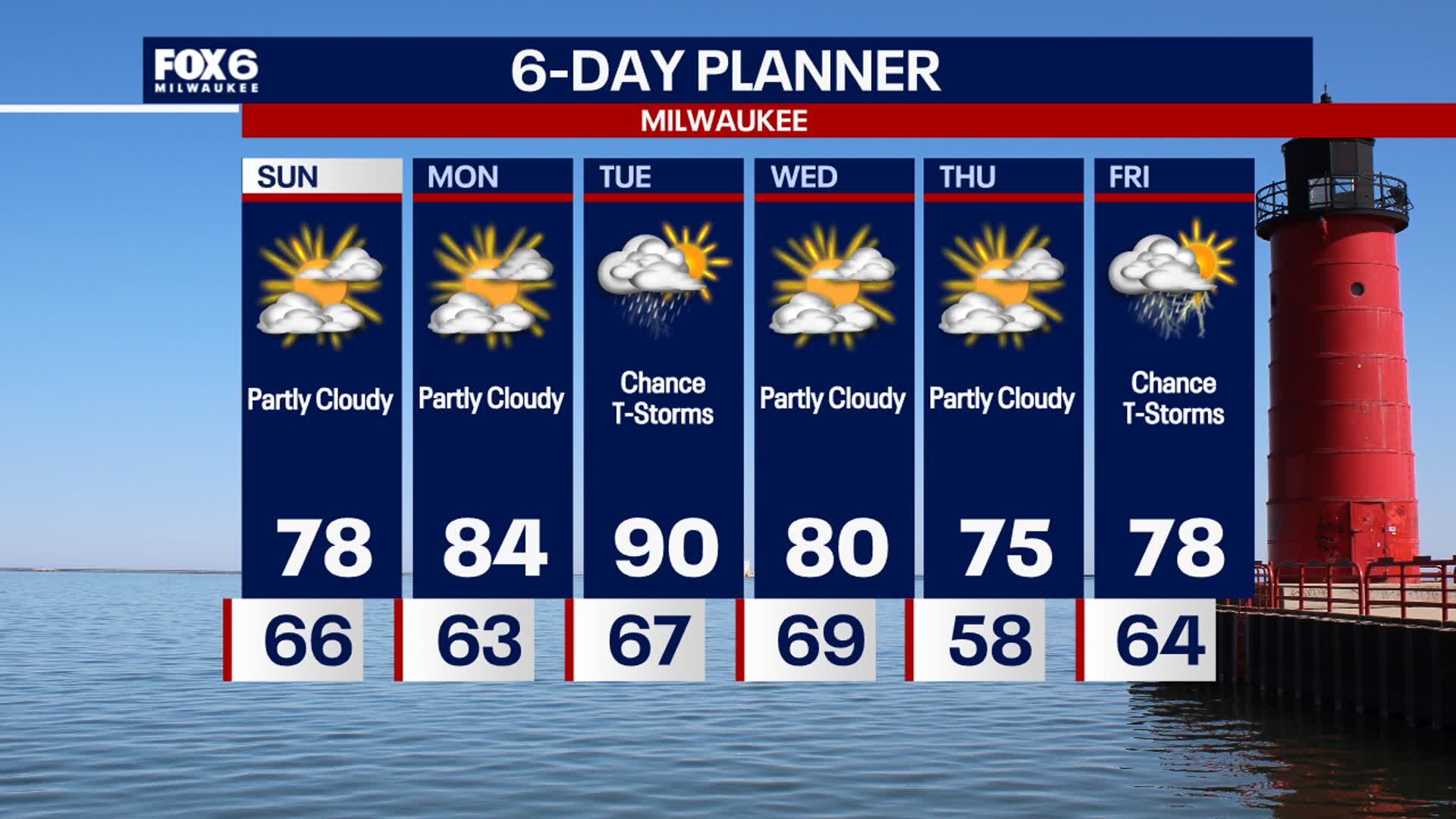
A much calmer day today behind yesterday's cold front. Temperatures will only be slightly cooler but dewpoints have fallen significantly. We should get some sunny break this afternoon and become mostly sunny on Monday however, rain and thunderstorms return on Tuesday. We get hot and humid again by Tuesday with highs reaching 90 once again and dewpoints returning to near 70. Rain and thunderstorms are likely again Tuesday before we dry up for Wednesday and Thursday.
A much calmer day today behind yesterday's cold front. Temperatures will only be slightly cooler but dewpoints have fallen significantly. We should get some sunny break this afternoon and become mostly sunny on Monday however, rain and thunderstorms return on Tuesday. We get hot and humid again by Tuesday with highs reaching 90 once again and dewpoints returning to near 70. Rain and thunderstorms are likely again Tuesday before we dry up for Wednesday and Thursday.
Weather Webcast with Stephanie Barichello
Thunderstorms are likely this evening and may be severe with damaging wind, tornadoes and heavy rainfall. There is a flood watch in effect for most of SE WI. After tonight, we dry out a bit Sunday, although a few sprinkles will still be possible at times. Hot and humid with storms again by Tuesday.
Thunderstorms are likely this evening and may be severe with damaging wind, tornadoes and heavy rainfall. There is a flood watch in effect for most of SE WI. After tonight, we dry out a bit Sunday, although a few sprinkles will still be possible at times. Hot and humid with storms again by Tuesday.

Weather webcast with Rob Haswell
A busy day today with a Flood Watch in place for most of our viewing area. Periods of rain and thunderstorms could lead to flash flooding. Stronger storms are expected later today with severe storms possible. We will warm into the 80s today with cooler conditions to the north and much warmer conditions to the south. We should dry up on Sunday but rain and thunderstorms returns on Tuesday.
A busy day today with a Flood Watch in place for most of our viewing area. Periods of rain and thunderstorms could lead to flash flooding. Stronger storms are expected later today with severe storms possible. We will warm into the 80s today with cooler conditions to the north and much warmer conditions to the south. We should dry up on Sunday but rain and thunderstorms returns on Tuesday.
Weather Webcast with Chief Meteorologist Tom Wachs
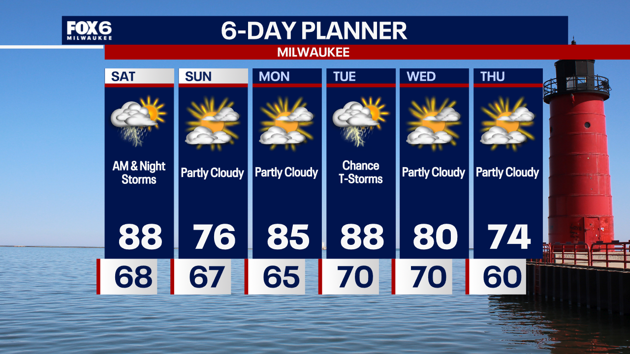
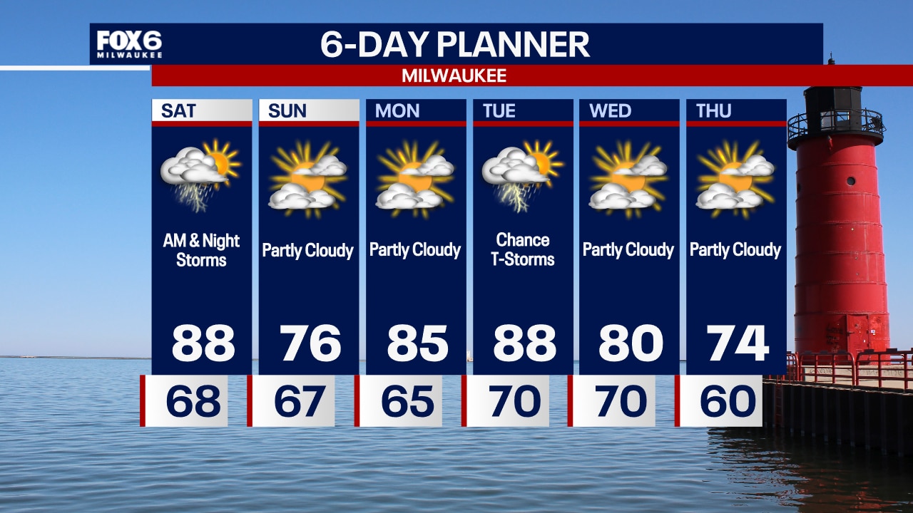
Waves of t-storms and fog overnight with temperatures in the 60s. Off-and-on rain/storms with heavy rain possible Saturday. Highs in the mid-to-upper 80s. A squall line of severe storms is possible Saturday night.
Waves of t-storms and fog overnight with temperatures in the 60s. Off-and-on rain/storms with heavy rain possible Saturday. Highs in the mid-to-upper 80s. A squall line of severe storms is possible Saturday night.
Weather Webcast with Chief Meteorologist Tom Wachs
Fog near the lake tonight with scattered t-storms possible. Temperatures dropping into the 60s. Multiple rounds of storms possible Saturday, especially AM and again at night. Highs in the 80s. Severe storms possible Saturday night.
Fog near the lake tonight with scattered t-storms possible. Temperatures dropping into the 60s. Multiple rounds of storms possible Saturday, especially AM and again at night. Highs in the 80s. Severe storms possible Saturday night.
Weather webcast with Rob Haswell
A warm front pushes back into our area today with some warmer and more humid air. It also brings instability and a chance for strong to severe thunderstorms. A Flood Watch goes into effect this afternoon for Waukesha, Jefferson, Washington, Dodge and Fond du Lac counties as well as areas farther to the west. Heavy rain is possible in many areas and the areas that have seen recent heavier rain are susceptible to flooding and could see flash flooding with any downpours that occur.
A warm front pushes back into our area today with some warmer and more humid air. It also brings instability and a chance for strong to severe thunderstorms. A Flood Watch goes into effect this afternoon for Waukesha, Jefferson, Washington, Dodge and Fond du Lac counties as well as areas farther to the west. Heavy rain is possible in many areas and the areas that have seen recent heavier rain are susceptible to flooding and could see flash flooding with any downpours that occur.
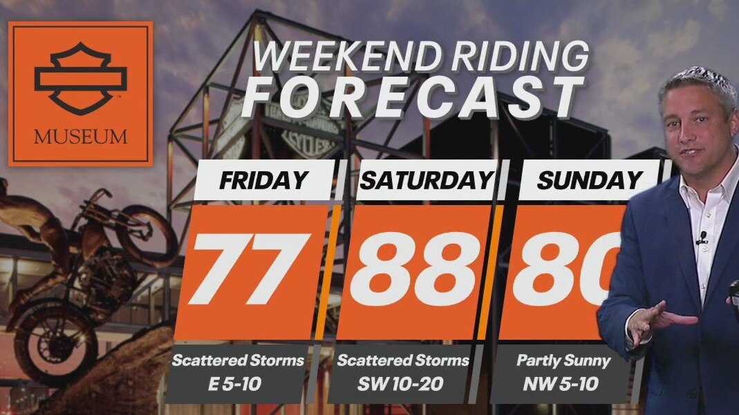
Weekend Riding Forecast for June 21-23
It'll be a mixed bag of weather depending on where you are in the state. FOX6's Tom Wachs has your Weekend Riding Forecast for June 21-23, 2024.
It'll be a mixed bag of weather depending on where you are in the state. FOX6's Tom Wachs has your Weekend Riding Forecast for June 21-23, 2024.

Weather Webcast with Chief Meteorologist Tom Wachs
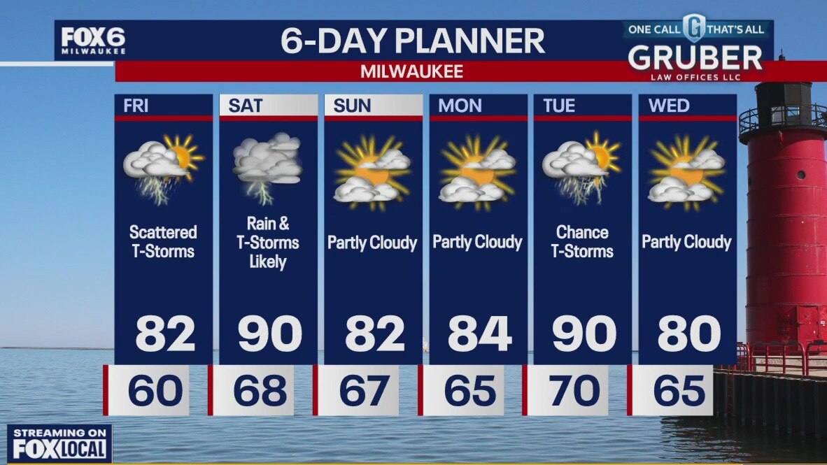
Slight chance for a t-storm overnight with temperatures around 60 by sunrise. Scattered t-storms on Friday, especially afternoon/evening. Highs in the low 70s at Summerfest, low 80s inland.
Slight chance for a t-storm overnight with temperatures around 60 by sunrise. Scattered t-storms on Friday, especially afternoon/evening. Highs in the low 70s at Summerfest, low 80s inland.