

Weather webcast with Rob Haswell
Partly sunny today with just a slight chance for a few isolated showers. Highs will be a little below average - particularly near Lake Michigan. A few clouds overnight leading into a sunny and dry day for Friday.
Partly sunny today with just a slight chance for a few isolated showers. Highs will be a little below average - particularly near Lake Michigan. A few clouds overnight leading into a sunny and dry day for Friday.
Weather Webcast with Chief Meteorologist Tom Wachs
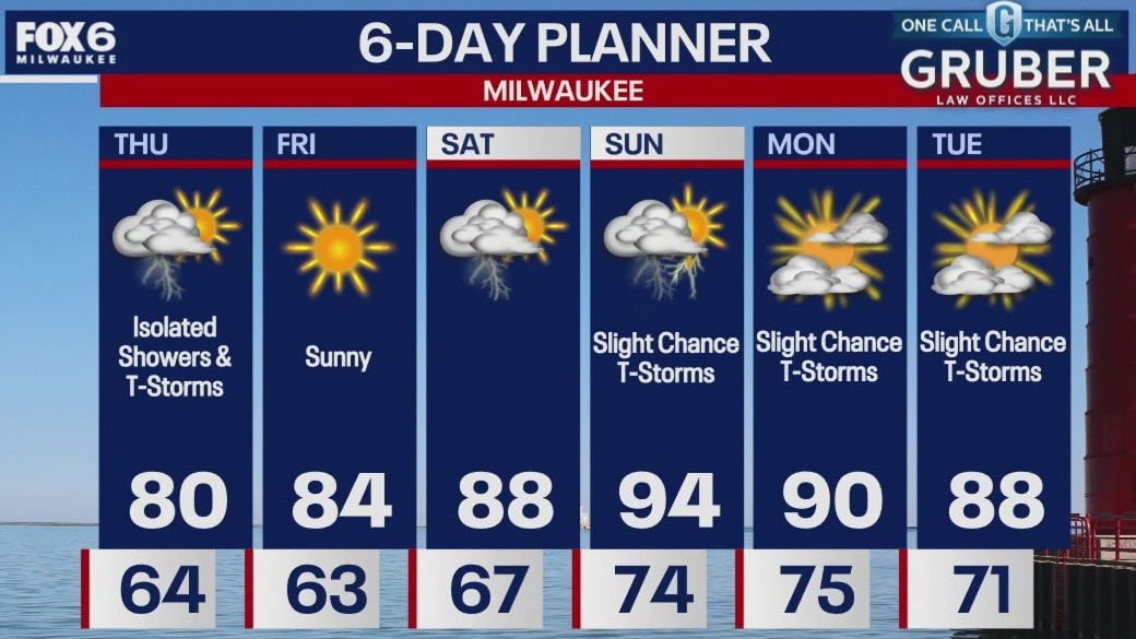
Increasing clouds overnight with a slight chance for a rain shower. Temperatures dropping into the 60s overnight. Partly to mostly cloudy on Thursday with a slight chance for t-storm. Highs in the 70s.
Increasing clouds overnight with a slight chance for a rain shower. Temperatures dropping into the 60s overnight. Partly to mostly cloudy on Thursday with a slight chance for t-storm. Highs in the 70s.
Weather Webcast with Chief Meteorologist Tom Wachs
Partly cloudy with a slight chance for a t-storm tonight. Temperatures dropping into the 60s. Partly sunny with a slight chance for a t-storm on Thursday. Highs in the 70s.
Partly cloudy with a slight chance for a t-storm tonight. Temperatures dropping into the 60s. Partly sunny with a slight chance for a t-storm on Thursday. Highs in the 70s.
Weather webcast with Rob Haswell
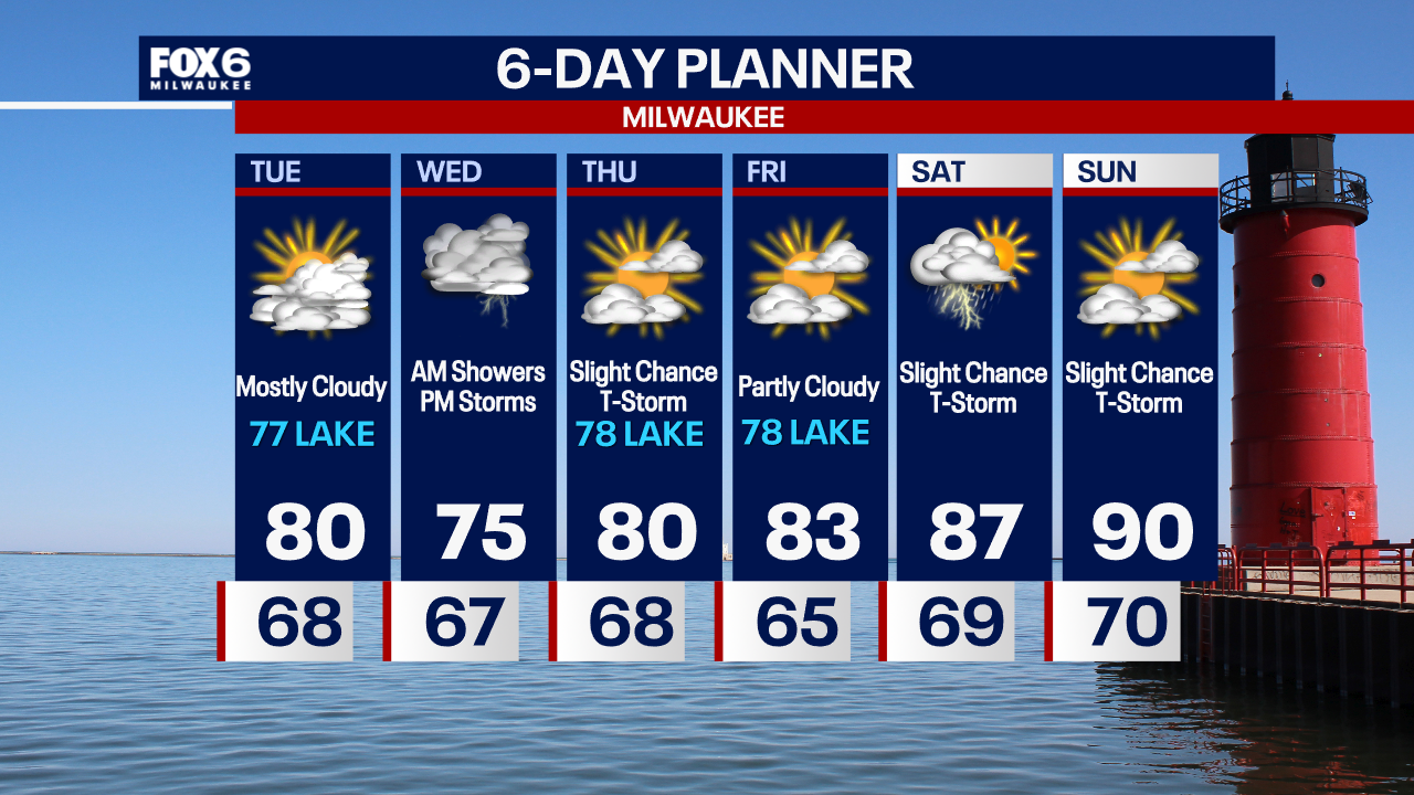
The remnants of Beryl are just brushing our areas this morning and should wind down by noon. Later afternoon we could see some isolated showers and thunderstorms. Highs today will be in the up 70s. We warm slightly tomorrow but the big push of heat arrives by the weekend. We will be in the upper 80s and low 90s from Saturday through at least Monday.
The remnants of Beryl are just brushing our areas this morning and should wind down by noon. Later afternoon we could see some isolated showers and thunderstorms. Highs today will be in the up 70s. We warm slightly tomorrow but the big push of heat arrives by the weekend. We will be in the upper 80s and low 90s from Saturday through at least Monday.

Weather Webcast with Chief Meteorologist Tom Wachs
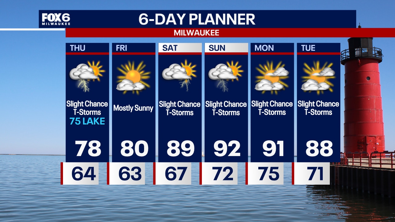
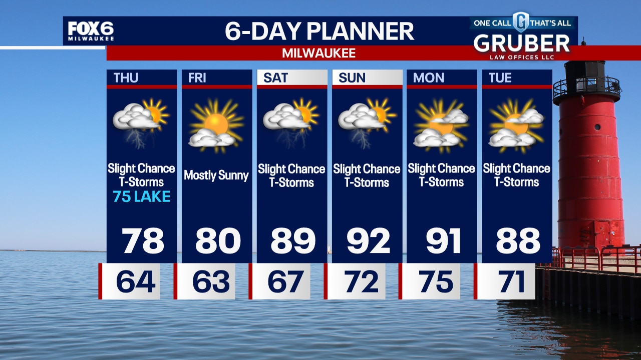
Rain showers will move in from the south tonight. Light rain continues into Wednesday morning. Mainly light rainfall amounts. A stray afternoon t-storm possible on Wednesday with highs in the 70s.
Rain showers will move in from the south tonight. Light rain continues into Wednesday morning. Mainly light rainfall amounts. A stray afternoon t-storm possible on Wednesday with highs in the 70s.
Weather webcast with Rob Haswell
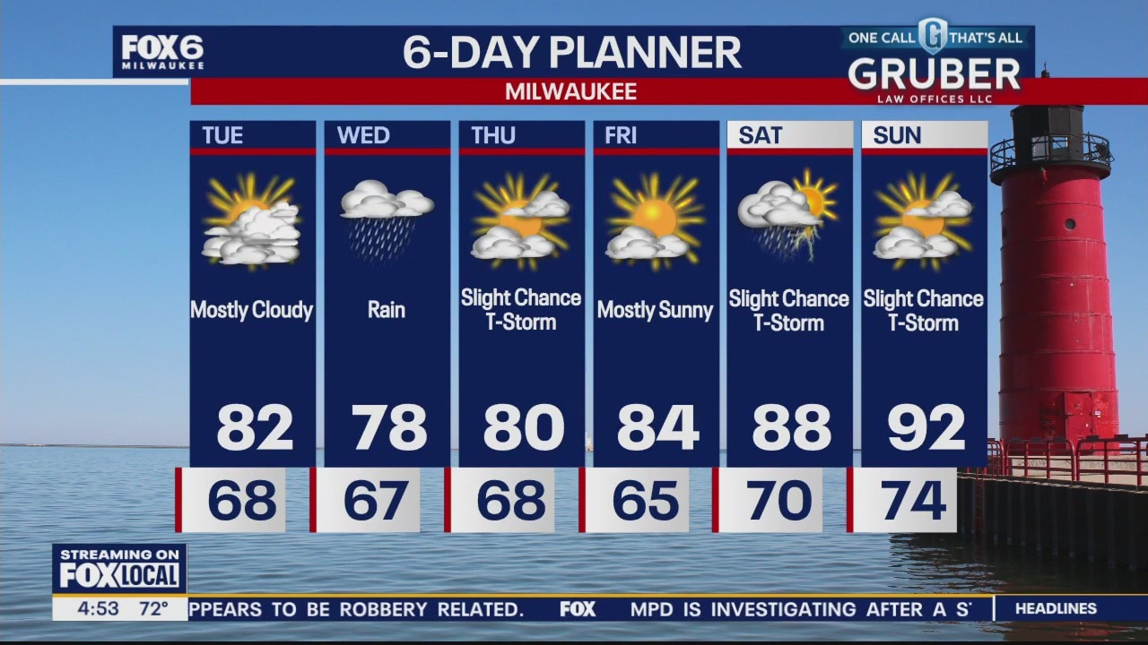
Most of our Tuesday should be dry but we will be watching later today as the remnants of Beryl move farther north and east. Highs will get to the low 80s inland today but a steady east wind will keep things in the 70s near Lake Michigan. Rain is likely tomorrow as the remnants of Beryl pass to the south. We could see a more significant rain in far southeast Wisconsin. We should dry up Thursday with slightly cooler than average temperatures but then a big warm up begins with 90s by the weekend.
Most of our Tuesday should be dry but we will be watching later today as the remnants of Beryl move farther north and east. Highs will get to the low 80s inland today but a steady east wind will keep things in the 70s near Lake Michigan. Rain is likely tomorrow as the remnants of Beryl pass to the south. We could see a more significant rain in far southeast Wisconsin. We should dry up Thursday with slightly cooler than average temperatures but then a big warm up begins with 90s by the weekend.
Weather Webcast with Chief Meteorologist Tom Wachs
Slight chance for a t-storm overnight. Temperatures dropping into the 60s. Increasing clouds ahead of the remnants of Beryl on Tuesday. Highs in the upper 70s to low 80s. Rain moves in Tuesday night.
Slight chance for a t-storm overnight. Temperatures dropping into the 60s. Increasing clouds ahead of the remnants of Beryl on Tuesday. Highs in the upper 70s to low 80s. Rain moves in Tuesday night.
Weather webcast with Rob Haswell
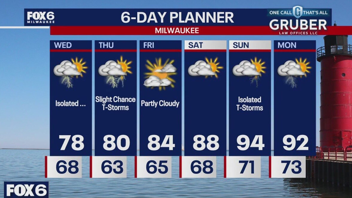
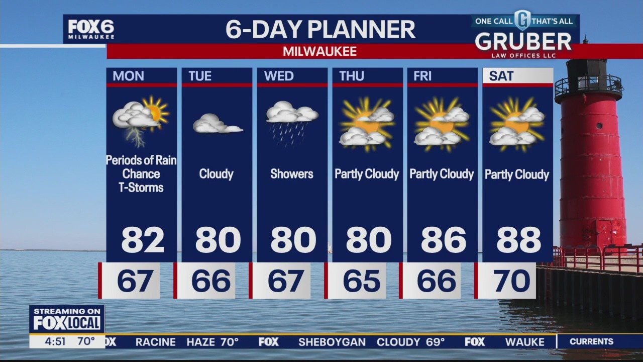
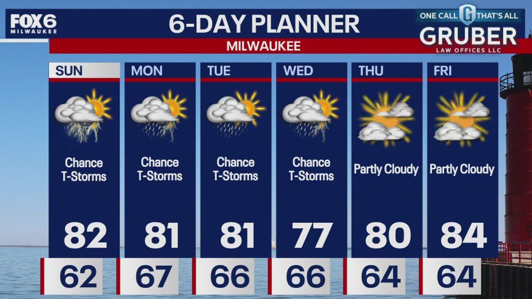
A low moving through the area brings periods of rain and thunderstorms today. Expect seasonal highs in the low 80s with lows in the mid to upper 60s. Tuesday should be a dry day before rain returns Wednesday. Highs will be a bit below the average. A big warm up is expected late week with 90s returning to the area by Sunday.
A low moving through the area brings periods of rain and thunderstorms today. Expect seasonal highs in the low 80s with lows in the mid to upper 60s. Tuesday should be a dry day before rain returns Wednesday. Highs will be a bit below the average. A big warm up is expected late week with 90s returning to the area by Sunday.

Weather Webcast with Chief Meteorologist Tom Wachs
Mostly cloudy with a slight chance for a t-storm overnight. Temperatures dropping into the 60s. Partly to mostly cloudy with a slight chance for a t-storm on Monday. High around 80.
Mostly cloudy with a slight chance for a t-storm overnight. Temperatures dropping into the 60s. Partly to mostly cloudy with a slight chance for a t-storm on Monday. High around 80.
Weather Webcast with Chief Meteorologist Tom Wachs
Scattered t-storms tonight, staying humid with temperatures falling into the 60s. Off-and-on scattered storms on Monday with a humid high in the upper 70s.
Scattered t-storms tonight, staying humid with temperatures falling into the 60s. Off-and-on scattered storms on Monday with a humid high in the upper 70s.
Weather webcast with Lisa Michaels
Slightly warmer and more humid on Sunday with highs in the low 80s. A few showers possible in the morning. A slight chance for a shower/storm in the afternoon. More storms follow late Sunday night into early Monday.
Slightly warmer and more humid on Sunday with highs in the low 80s. A few showers possible in the morning. A slight chance for a shower/storm in the afternoon. More storms follow late Sunday night into early Monday.

Weather Webcast with Stephanie Barichello
Clear and comfortable tonight, then there is a chance for showers Sunday morning through about midday. It'll be warmer and humid. Slight chance for a pop-up storm in the afternoon then another line of storms moves through Sunday night into Monday morning. Slight chance for storms through Wednesday, then some sunshine.
Clear and comfortable tonight, then there is a chance for showers Sunday morning through about midday. It'll be warmer and humid. Slight chance for a pop-up storm in the afternoon then another line of storms moves through Sunday night into Monday morning. Slight chance for storms through Wednesday, then some sunshine.
Weather webcast with Lisa Michaels
Partly Sunny skies with highs in the mid 70s. Cooler near the lake in the afternoon. Back to around 80 Sunday with higher humidity and a chance for storms, especially in the afternoon.
Partly Sunny skies with highs in the mid 70s. Cooler near the lake in the afternoon. Back to around 80 Sunday with higher humidity and a chance for storms, especially in the afternoon.
Weather Webcast with Stephanie Barichello
Partly sunny Saturday with temperatures in the middle 70s, then showers and storms return on Sunday. Another round of some rain Monday with slight chances lingering into Tuesday and Wednesday. Temperatures remain in the 70s and low 80s.
Partly sunny Saturday with temperatures in the middle 70s, then showers and storms return on Sunday. Another round of some rain Monday with slight chances lingering into Tuesday and Wednesday. Temperatures remain in the 70s and low 80s.

Weekend Riding Forecast for July 6-7
FOX6 Meteorologist Stephanie Barichello has your Weekend Riding Forecast for July 6-7, 2024.
FOX6 Meteorologist Stephanie Barichello has your Weekend Riding Forecast for July 6-7, 2024.

Weather Webcast with Stephanie Barichello
A few showers possible this evening then a beautiful Saturday ahead! Showers and storms return at times Sunday into Monday.
A few showers possible this evening then a beautiful Saturday ahead! Showers and storms return at times Sunday into Monday.

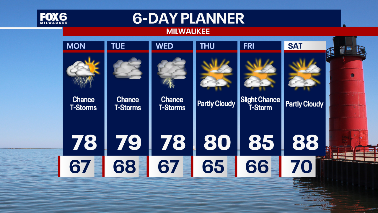
Weather webcast with Rob Haswell
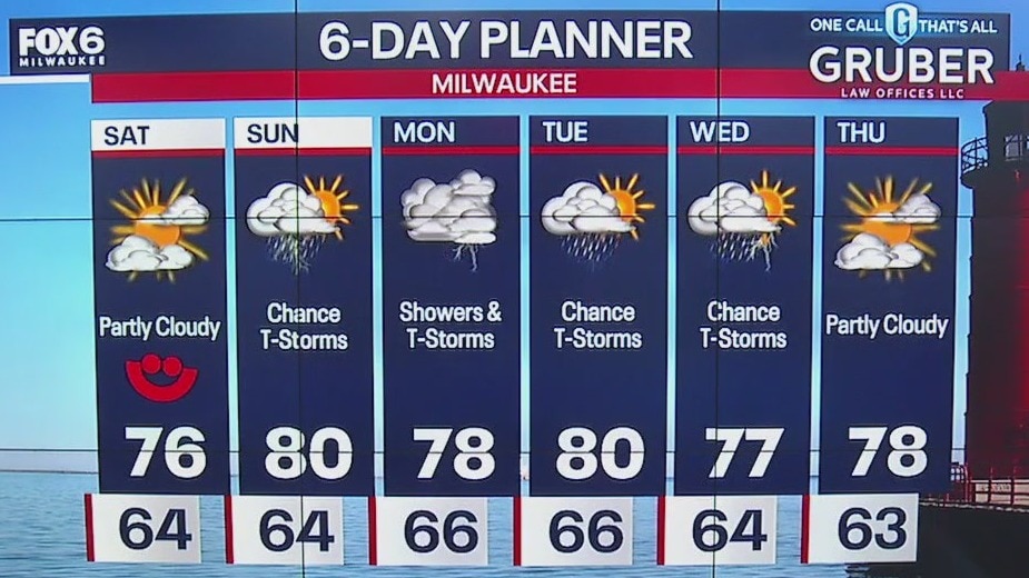
A low moving over our area today will keep us on the wet side with chances for thunderstorms. Temperatures will be below average, likely in the mid to upper 70s. We expect to dry up for Saturday but stay in the 70s. Another low arrives Sunday with more rain but slightly warmer temperatures.
A low moving over our area today will keep us on the wet side with chances for thunderstorms. Temperatures will be below average, likely in the mid to upper 70s. We expect to dry up for Saturday but stay in the 70s. Another low arrives Sunday with more rain but slightly warmer temperatures.

Weather Webcast with Stephanie Barichello
Storms likely tonight, then on and off showers and storms expected throughout the day Friday. Saturday is looking beautiful, then a few more storm chances Sunday into Monday.
Storms likely tonight, then on and off showers and storms expected throughout the day Friday. Saturday is looking beautiful, then a few more storm chances Sunday into Monday.
Weather webcast with Rob Haswell
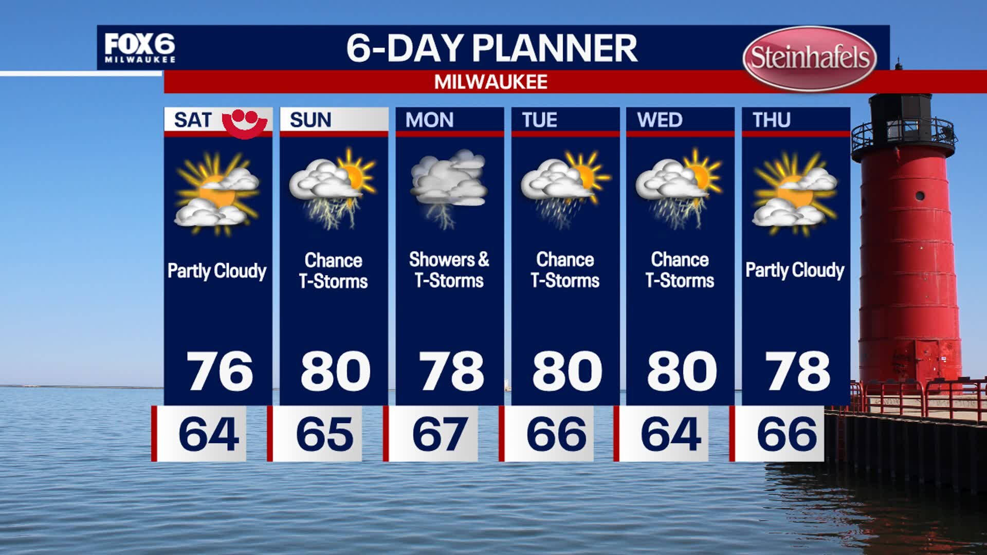
Ahead of a low most of the day, we warm into the low to mid 80s with noticeable but not terribly uncomfortable dew points. Isolated showers and thunderstorms are possible in the later afternoon with a steadier rain arriving overnight. A wet day for Friday with around a third to a half inch of accumulation likely. That will worsen flooding issues along our rivers and streams. We should be dry for Saturday but rain returns Sunday and into early next week.
Ahead of a low most of the day, we warm into the low to mid 80s with noticeable but not terribly uncomfortable dew points. Isolated showers and thunderstorms are possible in the later afternoon with a steadier rain arriving overnight. A wet day for Friday with around a third to a half inch of accumulation likely. That will worsen flooding issues along our rivers and streams. We should be dry for Saturday but rain returns Sunday and into early next week.
Weather Webcast with Chief Meteorologist Tom Wachs
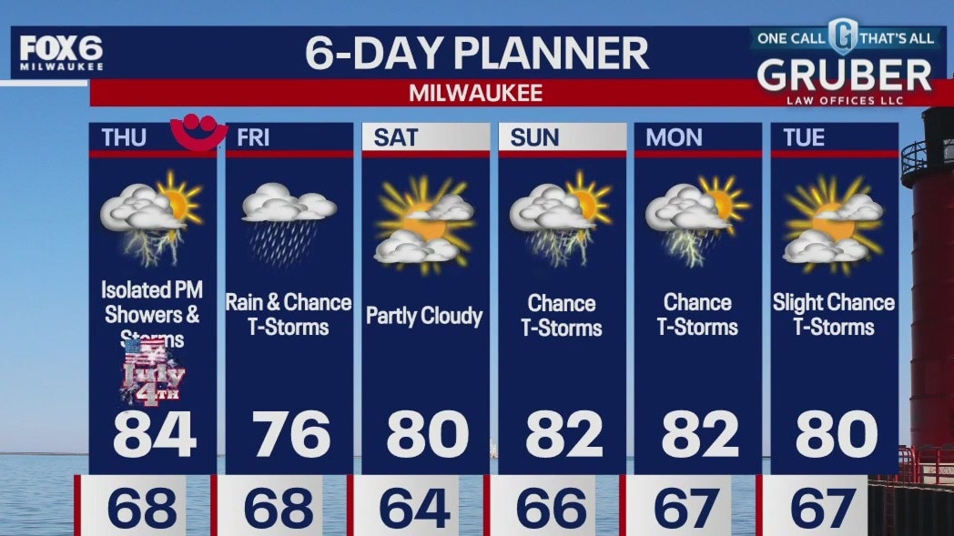
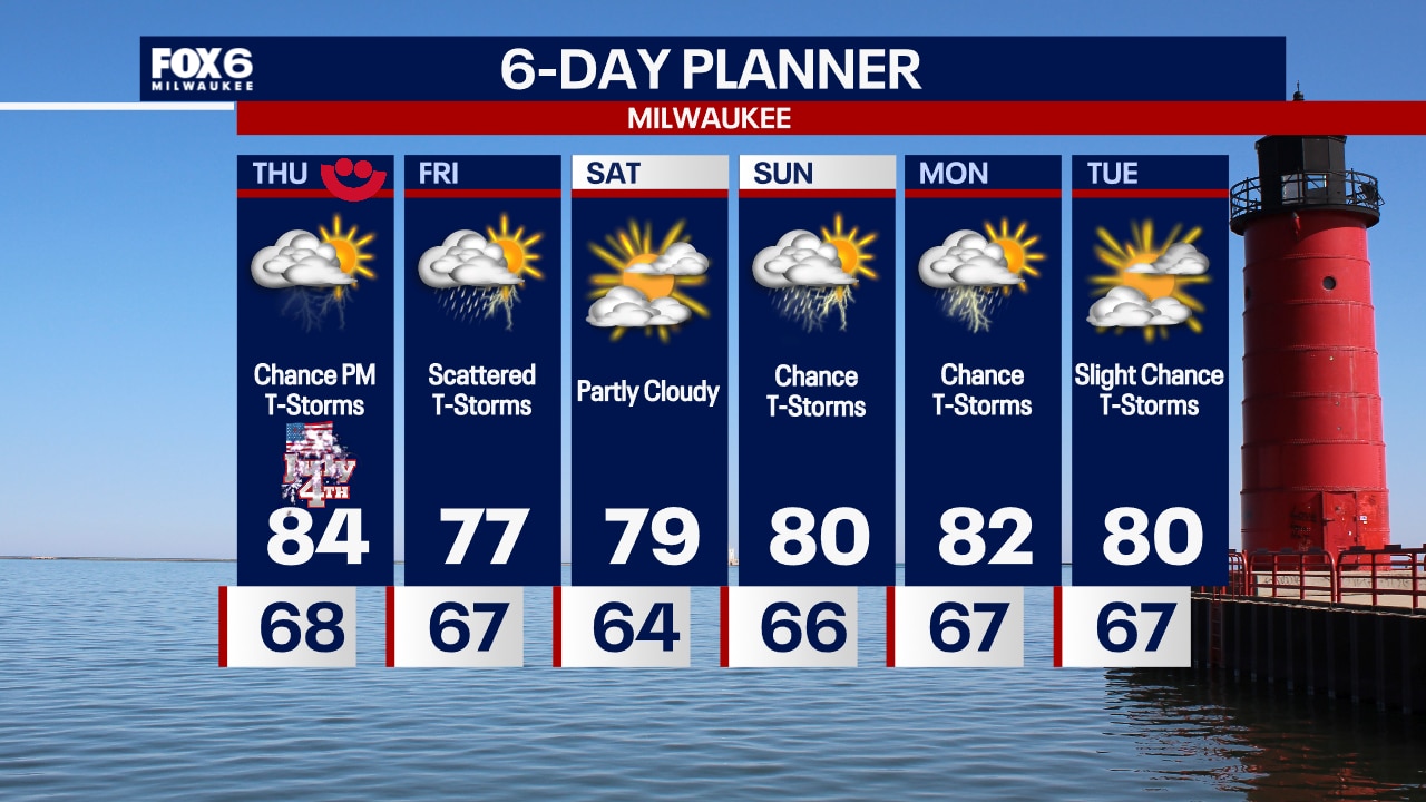
Partly cloudy on the 4th of July. An isolated t-storm is possible during the afternoon and again at night. Highs in the mid-80s inland, cooling into the 70s near the lake during the afternoon.
Partly cloudy on the 4th of July. An isolated t-storm is possible during the afternoon and again at night. Highs in the mid-80s inland, cooling into the 70s near the lake during the afternoon.