

Weather Webcast with Chief Meteorologist Tom Wachs
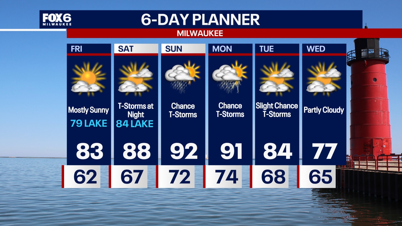
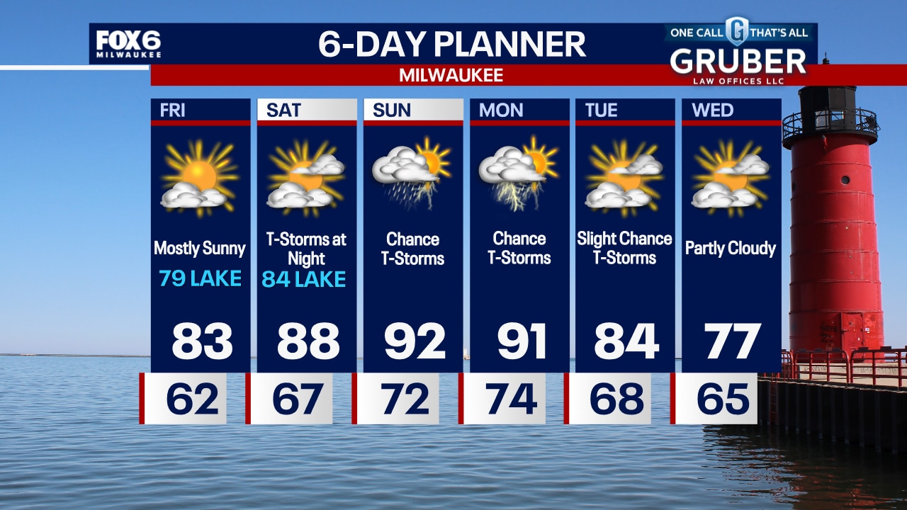
Quiet overnight with temperatures dropping into the 60s. Noticeably less humid on Wednesday with partly sunny skies. Highs in the upper 70s.
Quiet overnight with temperatures dropping into the 60s. Noticeably less humid on Wednesday with partly sunny skies. Highs in the upper 70s.

Weather Webcast with Chief Meteorologist Tom Wachs
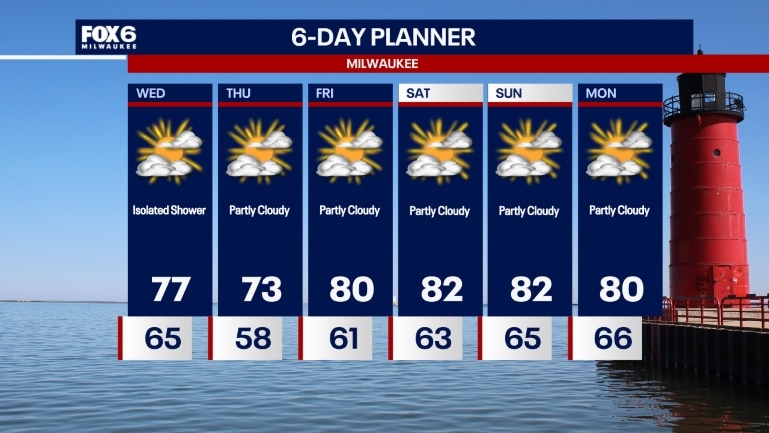
Partly cloudy tonight with humidity levels gradually dropping. Temperatures will drop into the 60s overnight. Partly sunny, breezy and less humid on Wednesday. Highs in the upper 70s. A stray rain shower is possible later in the day.
Partly cloudy tonight with humidity levels gradually dropping. Temperatures will drop into the 60s overnight. Partly sunny, breezy and less humid on Wednesday. Highs in the upper 70s. A stray rain shower is possible later in the day.


Indiana resident killed after tree falls on home amid severe weather identified
A person was killed when a tree fell on their house in Cedar Lake, Indiana, as powerful storms barreled through the Chicagoland area on Monday night.
A person was killed when a tree fell on their house in Cedar Lake, Indiana, as powerful storms barreled through the Chicagoland area on Monday night.

Weather Webcast with Stephanie Barichello
A stray shower is possible this afternoon, otherwise expect a mix of clouds and sun and temperatures in the 70s and 80s. Much lower dewpoints by tomorrow and sunshine lasts into the weekend.
A stray shower is possible this afternoon, otherwise expect a mix of clouds and sun and temperatures in the 70s and 80s. Much lower dewpoints by tomorrow and sunshine lasts into the weekend.
Weather webcast with Rob Haswell
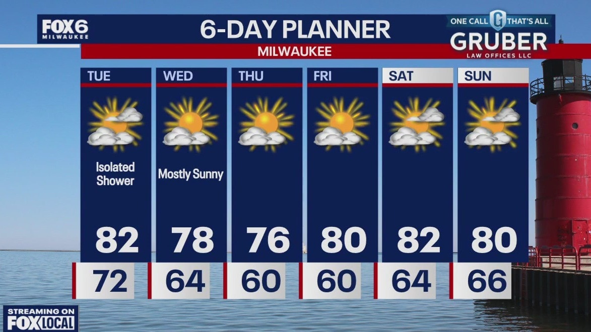
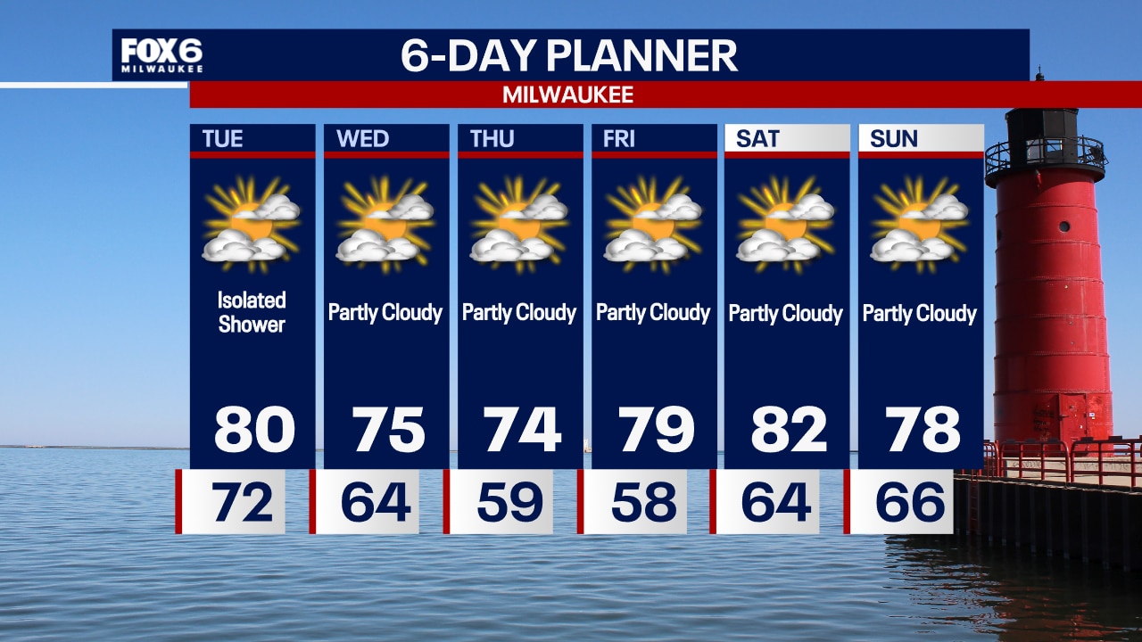
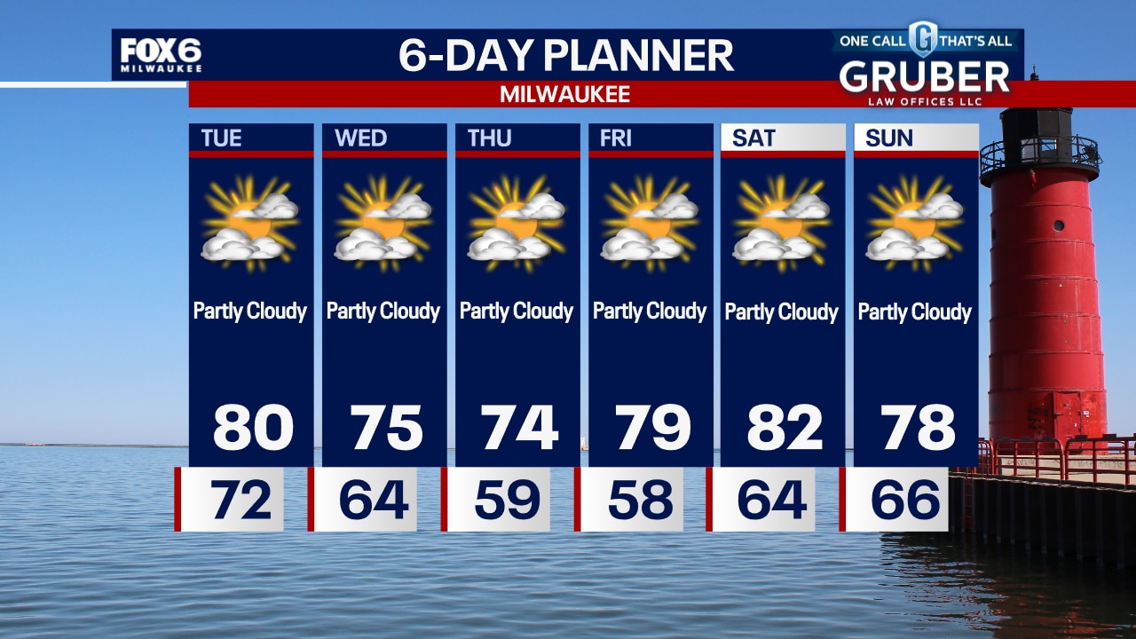
A much cooler and calmer day today but still a bit muggy. Highs will be in the low 80s but dew points will remain in the mid to upper 60s. There is a chance for a few isolated showers but otherwise partly to mostly sunny. We stay dry and cooler Wednesday and Thursday with highs in the 70s. No rain expected through the weekend. Temperatures will return to near seasonal.
A much cooler and calmer day today but still a bit muggy. Highs will be in the low 80s but dew points will remain in the mid to upper 60s. There is a chance for a few isolated showers but otherwise partly to mostly sunny. We stay dry and cooler Wednesday and Thursday with highs in the 70s. No rain expected through the weekend. Temperatures will return to near seasonal.
Weather Webcast with Chief Meteorologist Tom Wachs
Rain ending overnight with temperatures in the 70s. One more humid day on Tuesday with a few isolated rain showers. High around 80.
Rain ending overnight with temperatures in the 70s. One more humid day on Tuesday with a few isolated rain showers. High around 80.
Weather Webcast with Chief Meteorologist Tom Wachs
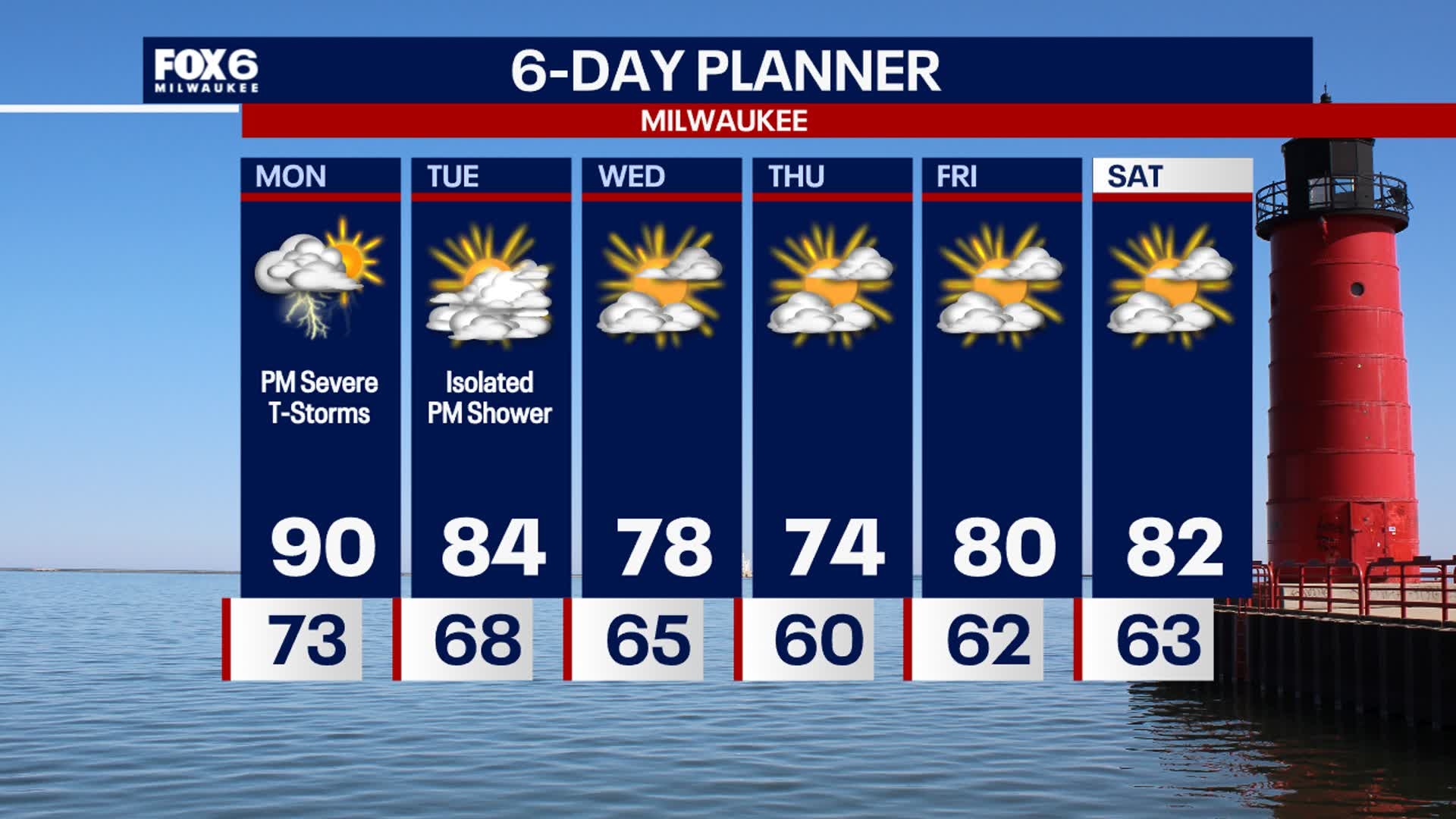
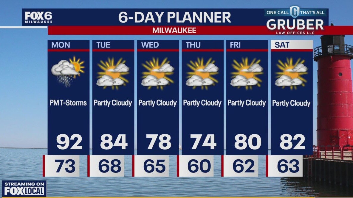
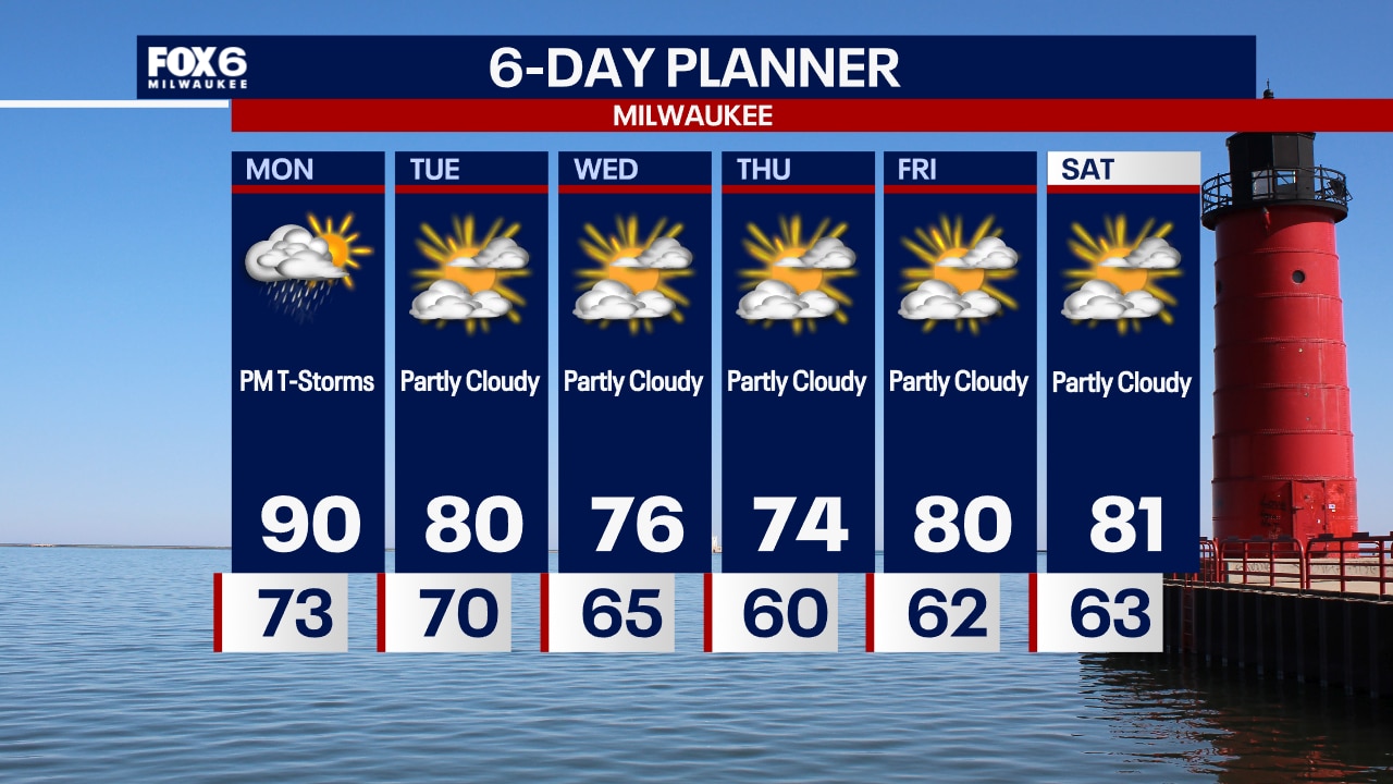
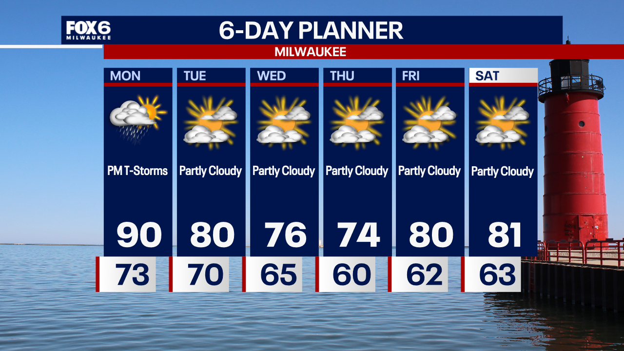
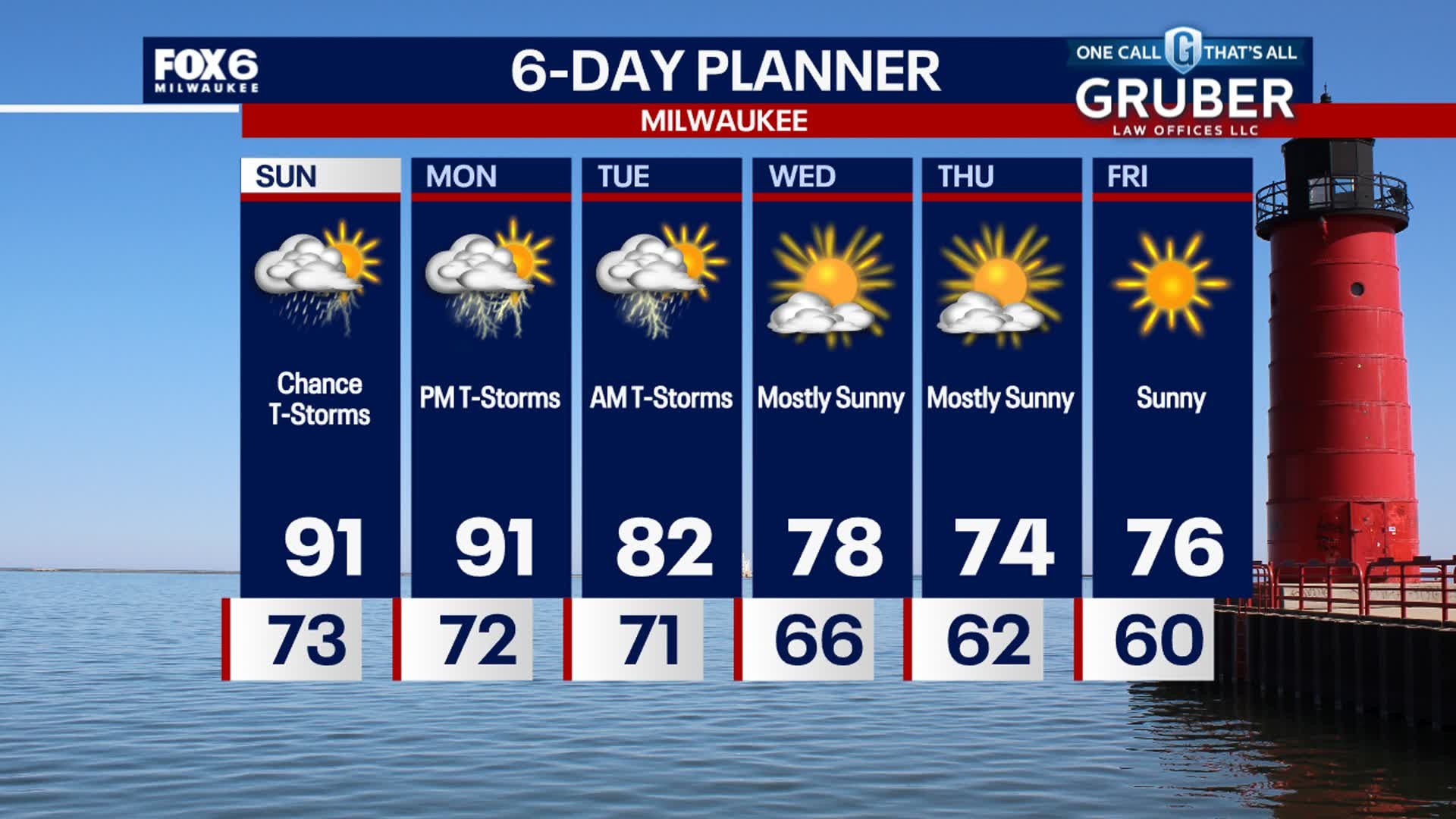
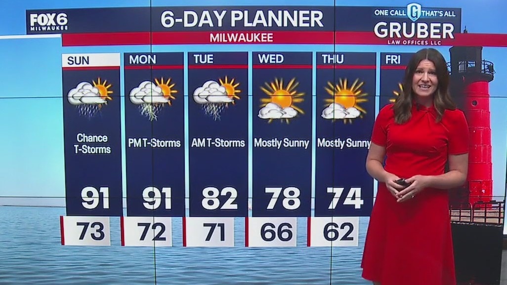
There is a chance for severe t-storms through midnight. It will stay humid with temperatures in the 70s. Partly sunny, cooler but still humid on Tuesday. High around 80.
There is a chance for severe t-storms through midnight. It will stay humid with temperatures in the 70s. Partly sunny, cooler but still humid on Tuesday. High around 80.
Weather Webcast with Stephanie Barichello
Hot and humid today, then a chance for severe weather between 6-10pm. Strong, damaging wind is the primary threat but large hail, tornadoes and flooding will also be possible. Eyeing areas along and south of I94 to the IL state line for the greatest threat.
Hot and humid today, then a chance for severe weather between 6-10pm. Strong, damaging wind is the primary threat but large hail, tornadoes and flooding will also be possible. Eyeing areas along and south of I94 to the IL state line for the greatest threat.
Weather webcast with Rob Haswell
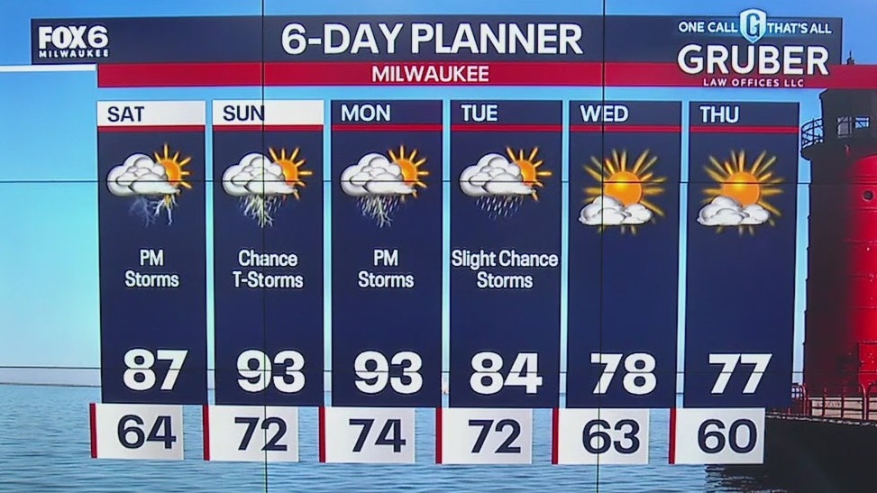
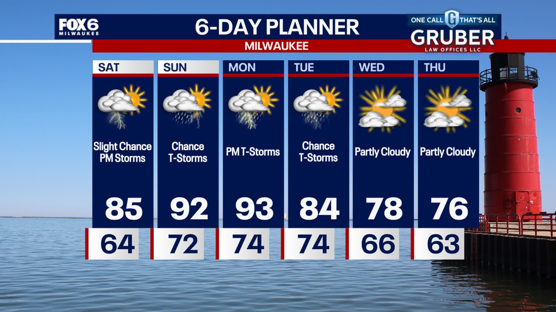
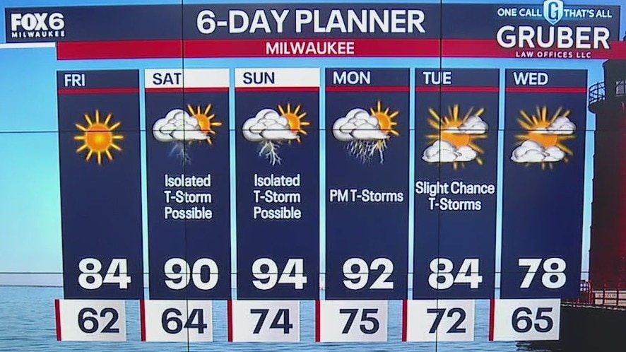
Another hot and humid day with a chance for strong to severe storms later this afternoon and early evening. Highs today will reach the low 90s and feel much hotter with dew points in the low to mid 70s. As a cold front crosses our area later today, it will generate more storms. There is a risk for severe weather later today. Behind the cold front we calm down, cool down and become much less humid for a few days.
Another hot and humid day with a chance for strong to severe storms later this afternoon and early evening. Highs today will reach the low 90s and feel much hotter with dew points in the low to mid 70s. As a cold front crosses our area later today, it will generate more storms. There is a risk for severe weather later today. Behind the cold front we calm down, cool down and become much less humid for a few days.
Weather Webcast with Chief Meteorologist Tom Wachs
Storms moving out overnight with some patchy fog possible. It will stay humid with temperatures in the 70s. Partly sunny, hot and humid on Monday. High around 90. T-Storms are possible at night.
Storms moving out overnight with some patchy fog possible. It will stay humid with temperatures in the 70s. Partly sunny, hot and humid on Monday. High around 90. T-Storms are possible at night.
Weather Webcast with Chief Meteorologist Tom Wachs
Strong to severe t-storms possible through 12am. Wind/hail/heavy rain possible. Staying humid all night. Hot and humid Monday with another chance for strong storms after 4pm.
Strong to severe t-storms possible through 12am. Wind/hail/heavy rain possible. Staying humid all night. Hot and humid Monday with another chance for strong storms after 4pm.
Weather Webcast with Stephanie Barichello
Hot and humid today with temperatures in the 90s and dewpoints in the 70s. Storms are possible again this evening, possibly severe, then expect more heat and humidity on Monday. Scattered severe storms also possible Monday then we dry out later Tuesday. Cooler and sunny the rest of the week.
Hot and humid today with temperatures in the 90s and dewpoints in the 70s. Storms are possible again this evening, possibly severe, then expect more heat and humidity on Monday. Scattered severe storms also possible Monday then we dry out later Tuesday. Cooler and sunny the rest of the week.
Weather webcast with Stephanie Barichello
After a morning batch of storms, expect hot and very humid conditions the rest of the day. Temperatures reach into the low 90s today with heat indices in the triple digits at times.
After a morning batch of storms, expect hot and very humid conditions the rest of the day. Temperatures reach into the low 90s today with heat indices in the triple digits at times.
Weather webcast with Lisa Michaels
Warm and humid Saturday with highs in the mid to upper 80s. Slight chance of storms this afternoon with higher chances late Saturday night. Strong to severe likely. Even warmer temps on Sunday and Monday with highs in the low 90s.
Warm and humid Saturday with highs in the mid to upper 80s. Slight chance of storms this afternoon with higher chances late Saturday night. Strong to severe likely. Even warmer temps on Sunday and Monday with highs in the low 90s.
Weather Webcast with Stephanie Barichello
A pleasant Friday night ahead then we're heating up this weekend -- especially Sunday into Monday! Both days could have heat indices or "feel like" temperatures in the 100s. Storms are also possible Saturday to about Tuesday, but there will still be plenty of dry time.
A pleasant Friday night ahead then we're heating up this weekend -- especially Sunday into Monday! Both days could have heat indices or "feel like" temperatures in the 100s. Storms are also possible Saturday to about Tuesday, but there will still be plenty of dry time.
Weather webcast with Rob Haswell
High pressure finally takes over our forecast for a sunny and dry day today. Highs will warm into the low 80s although it will be a few degrees cooler near Lake Michigan with a southeast wind all day.
High pressure finally takes over our forecast for a sunny and dry day today. Highs will warm into the low 80s although it will be a few degrees cooler near Lake Michigan with a southeast wind all day.
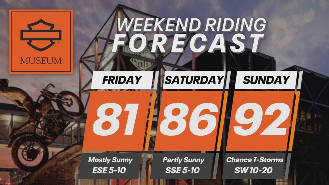
Weekend Riding Forecast for July 12-14
FOX6's Chief Meteorologist Tom Wachs has your Weekend Riding Forecast for July 12-14, 2024.
FOX6's Chief Meteorologist Tom Wachs has your Weekend Riding Forecast for July 12-14, 2024.

Weather webcast with Rob Haswell
High pressure finally takes over our forecast for a sunny and dry day today. Highs will warm into the low 80s although it will be a few degrees cooler near Lake Michigan with a southeast wind all day.
High pressure finally takes over our forecast for a sunny and dry day today. Highs will warm into the low 80s although it will be a few degrees cooler near Lake Michigan with a southeast wind all day.
Weather Webcast with Chief Meteorologist Tom Wachs
Mostly clear overnight with fog possible along the lakeshore. Temperatures in the 60s. Mostly sunny on Friday with highs in the upper 70s near the lake, low-to-mid 80s inland.
Mostly clear overnight with fog possible along the lakeshore. Temperatures in the 60s. Mostly sunny on Friday with highs in the upper 70s near the lake, low-to-mid 80s inland.
Weather Webcast with Chief Meteorologist Tom Wachs
Mostly clear tonight with fog possible along the lake. Temperatures dropping into the 60s. Mostly sunny on Friday with highs in the upper 70s near the lake, low-to-mid 80s inland.
Mostly clear tonight with fog possible along the lake. Temperatures dropping into the 60s. Mostly sunny on Friday with highs in the upper 70s near the lake, low-to-mid 80s inland.